Lugares de interés (POIs) del Mapa
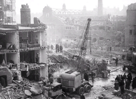
0: New Cross Road

November 25, 1944, 168 dead.
Más sobre New Cross Road
1: Hughes Mansions, Vallance Road
Más sobre Hughes Mansions, Vallance Road
3: Mackenzie Road
From reader Andy B: "My father's brothers had gone to bed when that V2 hit. Windows were blown in and a large shard of glass embedded itself in the settee. My father was leaning forward playing with a dinky toy and reckons that if he had been sitting back in the settee the glass would have injured him severely if not fatally."
Más sobre Mackenzie Road
5: Axminster Road
Information based on reader report from Patricia Parisi: "I was buried under rubble in bed with my sister and remember being collected by ambulance and taken to a school rest centre.I seem to remember being told that there were many deaths (about 48)...I have been back to see the site of our old house No.6 Axminster Rd. and there are now flats there called Bennett Court."
Más sobre Axminster Road
7: Henry Road, Chelmsford
http://www.thisistotalessex.co.uk/witham/CHELMSFORD-Hoffman-s-hero-relives-terrifying-night-German-rocket-hit-factoryarticle-772981-details/article.html
Más sobre Henry Road, Chelmsford
9: Hazelhurst Road
Reader comment: "71 Hazelhurst Rd was the Location of the Hit it was on Sunday 19 November 1944 at around 800-830 am
Not the date you have
There was more then 35 killed more like 300 as two or three shelters where never found each had about 100 in them. How do I know I lived near there and my house took some of the blast and my late wife was in it the house that took the hit that is why she lived he G-Mother was killed and the rest of her family sufferd for the rest off there life. The road never rebuilt as it was"
Más sobre Hazelhurst Road
10: Borough High Street
Más sobre Borough High Street
12: Barnby Street
March 1, 1945, 30 Dead
http://www.bbc.co.uk/ww2peopleswar/stories/86/a3332486.shtml
Más sobre Barnby Street
13: Shooters Hill Road
Casualties, 22 to Brook/St Alfege Hospitals. Building completely destroyed. Many casualties were on 89 bus passing at time of explosion.
Más sobre Shooters Hill Road
15: Crownfield Road
February 17, 1945, 25 Dead
http://www.bbc.co.uk/ww2peopleswar/stories/27/a4132027.shtml
Más sobre Crownfield Road
16: Finland Road
Más sobre Finland Road
18: Albert Road
March 16, 1945, 23 Dead http://www.flickr.com/photos/7291934@N08/3086949199/
Más sobre Albert Road
19: Gordon Hill, Enfield
"Enfield , Gordon Hill on this day 25th January 1945 , a V2 landed between gardens at top of Gordon and Lavender Hills, approx 7.30 am in the Morning , RIP Elizabeth Hayes (Great Aunt) plus twenty others . Crater can still be seen on Google earth as dark shape in back Gardens of rebuilt houses One survivor, rescured from the back of the house (no 111) lived onto to be a hundred spending the rest of his live at Worthing in Sussex."
Más sobre Gordon Hill, Enfield
20: Southborough Lane
Conflicting report on BBC suggests over 100 dead, while 'Doodlebugs and Rockets' claims 24
.
http://www.bbc.co.uk/ww2peopleswar/stories/74/a6027374.shtml
Más sobre Southborough Lane
22: Plaistow Road
January 4, 1945, 20 Dead
http://www.raynham.org/content/view/54/55/
Más sobre Plaistow Road
23: Sunfields Place
http://www.sunfieldschurch.org.uk/historyofsunfields.html
Más sobre Sunfields Place
24: Duke Street
Más sobre Duke Street
26: Bawn's Factory, Blackhorse Lane
Más sobre Bawn's Factory, Blackhorse Lane
27: Great Dover Street
Más sobre Great Dover Street
 January 27, 1945, 17 Dead
30: Chingford Road
Más sobre Chingford Road
31: Freemasons Road
January 13, 1945, 15 Dead
http://www.raynham.org/content/view/54/55/
Más sobre Freemasons Road
32: Adolphus Street
'Doodlebugs and Rockets' has this as Adolphos Road, on January 6, with 20 dead.
http://www.flyingbombsandrockets.com/V1_summary_se8.html
Más sobre Adolphus Street
33: Adelaide Avenue
Más sobre Adelaide Avenue
36: Ley Street, Illford
February 18, 1945, 14 Dead.
http://www.bbc.co.uk/ww2peopleswar/stories/01/a8213401.shtml
Más sobre Ley Street, Illford
37: Woolwich Common
Source: Woolwich Civil Defence Logs courtesy of Steve Hunnisett.
14 fatal casualties (AC1 & Mrs Banner 36 Jackson St, Mrs Dear & Miss Dear 28 Jackson St, Mr & Mrs Wilmshurst 24 Jackson St, Sgt Baughton 23 Jackson St, Tony (6) & Jacqueline Sault (4) 24 Jackson St, Mrs Scrivener 26 Jackson St, Mr & Mrs Starkie 20 Jackson St, Mrs Darby 6 Millward St, Mrs Deane 22 Jackson St) 43 casualties to Brook and War Memorial Hospitals, 10 treated at FAP, 61 at Mobile Unit, 30 by Wardens - 144 in total. 76 people sent to Slade Rest Centre. 9 houses in Jackson St demolished, further 39 in Jackson and Millward Streets to be demolished. 44 houses in Jackson Street, Engineer Road, Millward Street, Gildsome Street and Spearman Street seriously damaged
Más sobre Woolwich Common
38: Regina Road
From reader MJN: "You can see footage of the bombing of Regina Road/Stroud Green toward the end of this clip http://www.britishpathe.com/record.php?id=13244"
Más sobre Regina Road
39: Duncroft
Source: Woolwich Civil Defence Logs courtesy of Steve Hunnisett
Más sobre Duncroft
40: Calton Road
Más sobre Calton Road
41: Moordown
Hit 66-70 Moordown.
Source: Woolwich Civil Defence Logs courtesy of Steve Hunnisett.
Más sobre Moordown
42: Billet Road
Más sobre Billet Road
43: Blackhorse Road
From reader Desmond: "I live in longfield aveune, and a V2 landed in my street in 1944, it destroyed the houses that were at the end of the street, there are flats there now, and on the other side of Blackhorse road which it also destroyed. the flats were bulid in 1952."
Más sobre Blackhorse Road
44: New City Road
Comment from reader Graham Rogers" "It landed on Dillerways the bakery killing around 10 I was told."
Comment from reader Mikanmon: "My grandfather lived at No 1 Lichfield Road and had stayed home from work unwell that day in March 1945. He was sleeping in the armchair with his Cocker Spaniel on his lap when the blast hit. It took rescuers and family over 15 hours to find him and dig him out, still alive. The family put his survival down to his loyal canine absorbing some of the impact from falling debris. I was 8 years old at the time and my mother told me that it was impossible to seperate the streets as the whole area was a mass of rubble."
Note - reader comment is currently the only source for this pointl
Más sobre New City Road
45: Sutton-at-Hone
Location unknown, but near a fish bar and butchers. From 'Doodlebugs and Rockets'
Más sobre Sutton-at-Hone
47: Endsleigh Gardens, Ilford
From 'Doodlebugs and Rockets'. Aerial image included.
Más sobre Endsleigh Gardens, Ilford
48: Wickenden Road, Sevenoakes
Exact spot can be matched in Street View with image in 'Doodlebugs and Rockets'
Más sobre Wickenden Road, Sevenoakes
54: Longacre Road
Más sobre Longacre Road
55: Milton Road, Gravesend
'just outside Fort Gardens',
http://www.discovergravesham.co.uk/gravesend-chronology/1942-1948.html
Más sobre Milton Road, Gravesend
56: Lemna Road
Más sobre Lemna Road
57: Dairsee Road
Numbers 130-138 destroyed.
Source: Woolwich Civil Defence Logs courtesy of Steve Hunnisett.
Más sobre Dairsee Road
58: Angus Street
Más sobre Angus Street
59: Eglinton Road, Woolwich
Between numbers 130-140
Más sobre Eglinton Road, Woolwich
60: Sherard Road
Rear of 52 Sherard Road.
Source: Woolwich Civil Defence Logs courtesy of Steve Hunnisett.
Más sobre Sherard Road
62: Fairfield Road, Epping
March 22, 1945, 7 Dead
http://www.fylde.demon.co.uk/duffell2.htm
Más sobre Fairfield Road, Epping
63: College Road
Más sobre College Road
64: Farnan Avenue
Más sobre Farnan Avenue
65: Regina Road
Más sobre Regina Road
66: Portland Avenue, Gravesend
(one source claims 4 dead)
http://www.discovergravesham.co.uk/gravesend-chronology/1942-1948.html
Más sobre Portland Avenue, Gravesend
67: Abbotts Gardens
Location: No.s 107-113
Reader contribution
http://www.the-archer.co.uk/archive/2009/2009Jan12.pdf
Más sobre Abbotts Gardens
68: Battersea Park Road
Comment from anonymous reader: "The five dead reported included a man and wife who owned a toy shop close to Simpson Street. Early in the war I used to spend a lot of time in that shop, they were very kind in their dealings with boys. The V2 exploded during the hours of darkness and woke me. It completely demolished the row of shops and the church at the crossroads of Battersea Park Road and Falcon Road."
Comment from Ted Dexter: "I believe that my grandmother (and her boyfriend) were two of the five killed in the Battersea Park V2 explosion on the 21st of November 1944. I have read an account of the memories of the toy shop husband and wife killed during this attack- which were so touching on http://www.flyingbombsandrocke.... Just wondered if anybody else has any information/memories or connections to this event. My grandmother was called Alice Quiggley or perhaps Gardner. I don't know the name of her boyfriend., but think that they both worked in the local cinema together and were in bed at the time the rocket hit the house."
Más sobre Battersea Park Road
69: Royal Arsenal, Area D78
Approx location from http://www.royalarsenalwoolwich.org.uk/ArsenalMap1931.jpeg
Source: Woolwich Civil Defence Logs courtesy of Steve Hunnisett.
Más sobre Royal Arsenal, Area D78
70: Green Lane
Rear of numbers 17-19.
Source: Woolwich Civil Defence Logs courtesy of Steve Hunnisett.
Más sobre Green Lane
71: Belmont Road, Erith
Location inferred from housing patterns.
Más sobre Belmont Road, Erith
72: Woodford New Road
Más sobre Woodford New Road
73: Holmes Avenue
Más sobre Holmes Avenue
74: Mornington Road
Reader comment: "my nan's road - mornington road in leytonstone was hit by a V2 as shown on the map & her house totally wiped out. thank god she survived as she was heavily pregnant with my dad at the time but she was badly injured & was found at the bottom of her garden. her daughter - my aunt was found in a wardrobe she would of been nearly 3 yeras old, she also survived. apparently my grandad when AWOL from the army when he found out to get home to her!"
Más sobre Mornington Road
75: Greenwich Church Street
Fell by Westminster Bank.
Más sobre Greenwich Church Street

78: Sydney Road
Reader contribution.
Reader comment from P Ryder: "I lived six houses from where the last house was destroyed completely in Sydney Rd N8. All I remember was the bang and all the dust. most of the internasl walls were demolished and you could see from the road through the house into the back garden. Only three people were killed the milkman and a woman and her grand-daughter. I was told that I was partialy deaf for about thrre weeks after the explosion."
Más sobre Sydney Road
79: Croham Valley Road
Comment from reader Dennis: "Extract from "Croydon & the second world war" Page 113 The Rocket. On the night of 29th December,1944 one fell immediately behind "Undercliff" at the junction of Conduit Lane & Chroham Valley Road. Three peple were killed. At that time I was a paper boy and when I went to deliver the paper the next morning all I found was the most enormous crater and the house completely destroyed. In this book there is a mass of detaied facts about all the raids non Croydon during the war. "
Más sobre Croham Valley Road
80: King George Lock
Source: Woolwich Civil Defence Logs courtesy of Steve Hunnisett.
Eye witness account: http://gihs.gold.ac.uk/gihs22.html
Más sobre King George Lock
81: Glenhurst Road
Based on reader comment from Valerie: "A V2 bomb fell in Glenhurst Avenue,Bexley sometime in 1944 in the early hours of the morning.I was a child between 6 and 7 at the time. Five of us survived in our house which blew to smithereens.It was the first night that we didn't go down to the Anderson Shelter which was located at the bottom of the garden.Three people were killed in our Avenue.One house was on fire from which a pregnant lady jumped from an upstairs window.my Sister Marion and I were rescued by some American Soldiers that were billeted near by.I can remember seeing a massive crater in the middle of the road.The houses were rebuilt and we eventually returned."
Location and date unknown.
Another comment from Valerie: "I feel it is important that I amend a detail that I previously reported about a V2 bomb falling in Glenhurst Avenue, Bexley. my Sister Marion after finding some old letters written by our Mother to our Father who at the time was fighting in Burma,told me that the V2 bomb actually fell at the beginning of March 1945, just 2 months before the end of the war. How unlucky was that ? Two other details come to mind about that terrible night. We all remembered our Grandfather emerging through the rubble in his woolly combs.and shouting above the chaos that he couldn't find his trousers. Also it was reported that our immediate neighbours Mr.and Mrs.Biss were blown straight through their roof and found themselves,still in bed at the bottom of the garden. (unharmed I might add)"
Más sobre Glenhurst Road
82: Kidbrooke Church
3 to hospital, 3 to FAP. Church demolished, blast damage to 15-133 Rochester Way, 44 Wricklemarsh Road
Data courtesy of Steve Hunnisett.
From reader davidb: "I was asleep in the in the basement of those old three storey Georgian houses. The impact was around 51°28'N 1°23', roughly halfway between "Stop 9" and St James church on the Google map. Our half of the house was later pulled down, but St James' church only lost its tiles and its spire. Considering how close the explosion was, that very much bears out "Blitz Street"'s conclusion that blast damage from V2's was strictly limited. We knew that at the time.
Sorry can't help with the date. I wish I knew. It must hve been a late one, because we had already been bombed out by a V1."
Más sobre Kidbrooke Church
84: Siebert Road
81 to hospital. 20 houses for demolition, 200 further affected
Más sobre Siebert Road
87: Wendover Road
December 13, 1944, 2 Dead.
Hit number 48.
Source: Woolwich Civil Defence Logs courtesy of Steve Hunnisett.
Más sobre Wendover Road
88: 112-126 Iverson Road
January 8, 1945, 2 Dead

Más sobre 112-126 Iverson Road
89: Vanbrugh Park
15 to hospital, 6 to FAP. Homeless to Rectory Field Rest Centre
Más sobre Vanbrugh Park
91: Greenwich High Road
35 to hospital. Randall Place LR Depot damaged, railway blocked, extensive superficial damage to Town Hall, shops demolished
Más sobre Greenwich High Road
92: Highbridge Street, Waltham Abbey
From 'Doodlebugs and rockets', where a photo can be found.
Más sobre Highbridge Street, Waltham Abbey
94: Banstead Mental Asylum
November 1944, 2 dead
http://www.socyberty.com/Military/108-Interesting-Facts-Pertaining-to-the-German-V1-and-V2-Flying-Bombs-of-World-War-II.564811
Más sobre Banstead Mental Asylum
95: Warwick Reservoir West
Más sobre Warwick Reservoir West
96: Royal Norwich Golf Club, Norfolk
Location unknown
Más sobre Royal Norwich Golf Club, Norfolk
97: Gordon Avenue
Más sobre Gordon Avenue
99: 24 Aldeburgh Street
Data courtesy of Steve Hunnisett.
Más sobre 24 Aldeburgh Street
100: Westmount Road
Rear of number 11.
Source: Woolwich Civil Defence Logs courtesy of Steve Hunnisett.
Más sobre Westmount Road
101: Spurgeon Street.
Más sobre Spurgeon Street.
102: Morden Terrace School
Albion Hill (now Coldbath Road). 1 fatal casualty (Ivy Ruler, aged 2) who was staying with the caretaker. 1 serious casualty (Mrs Ashenden - caretaker.) 2 minor casualties
Más sobre Morden Terrace School
103: Glengarry Road
Más sobre Glengarry Road
106: Carnbrook Road
Area known as Chandler's Orchard, 4 to hospital. Damage to property in Broad Walk & Ridgebrook Road
Más sobre Carnbrook Road
107: Sparrow's Lane
Source: Woolwich Civil Defence Logs courtesy of Steve Hunnisett.
Más sobre Sparrow's Lane
108: Johnson And Phillips Cable Department
15 to hospital, 25 to FAP. Large piece (4-5 cwt) of LRR outside 35 Swallowfield Road, also piece of LRR (fuel tank) on roof of 29 Sundorne Road
Data courtesy of Steve Hunnisett.
Más sobre Johnson And Phillips Cable Department
109: Madan Road, Westerham
From 'Doodlebugs and Rockets'
Más sobre Madan Road, Westerham
110: Elm Grove
Más sobre Elm Grove
112: Goodmayes Park
February 1945
At least one person killed
http://www.bbc.co.uk/ww2peopleswar/stories/01/a2037601.shtml
http://www.bbc.co.uk/ww2peopleswar/stories/80/a2061280.shtml
Más sobre Goodmayes Park
113: Crockenhill
Location unknown, close to Field Crouch Farm. Fourth V2 strike.
Más sobre Crockenhill
114: Magdalen Laver, Essex
Location unknown. 'destroyed village hall'.
Fifth V2 rocket to hit England.
http://www.bbc.co.uk/ww2peopleswar/stories/19/a4073519.shtml
Más sobre Magdalen Laver, Essex
115: North Fambridge, Essex
Location unknown, but satellite view offers this very suggestive crater.
Third V2 strike, after hits in Chiswick and Epping.
Más sobre North Fambridge, Essex
116: Ranworth, Norfolk
Location unknown. Hit a 'stubble field', blowing out windows in village.
Más sobre Ranworth, Norfolk
117: Surlingham
http://www.surlinghamschool.com/category/projects/surlingham-village-project/
Más sobre Surlingham
118: Evesham Avenue
Más sobre Evesham Avenue
119: Hopton, Suffolk
Valley Farm, Hopton. Location unknown
Más sobre Hopton, Suffolk
120: Great Witchingham, Norfolk
Location unknown, but this looks likely.
Más sobre Great Witchingham, Norfolk
121: Beeston St Lawrence, Norfolk
Landed in 'forest', location unknown, but this area looks like regrown trees.
Más sobre Beeston St Lawrence, Norfolk
122: Rockland St Mary, Norfolk
Landed close to school, with some serious injuries.
Más sobre Rockland St Mary, Norfolk
124: Ingworth, Norfolk
Near Manor Farm, Ingham, location unknown
Más sobre Ingworth, Norfolk
126: Knee Hill
Landed in garden of 'the cottage'.
Source: Woolwich Civil Defence Logs courtesy of Steve Hunnisett.
Más sobre Knee Hill
129: Thamesmead
'Off tripcock point'.
Source: Woolwich Civil Defence Logs courtesy of Steve Hunnisett.
Más sobre Thamesmead
130: 49-51 Jevington Way
Más sobre 49-51 Jevington Way
131: Lennard Road sports ground
Más sobre Lennard Road sports ground
133: Warwick Gardens
From reader Avril Knight-Sweeney: "" I was sitting in the kitchen one evening and Avril was asleep in her cot in the bedroom. Suddenly there was a terrific explosion. I rushed to the bedroom,jumping across the small landing,thinking that the house was falling apart it was rocking so much. After the explosion came the most awful sound I have ever heard. I rushed into the bedroom to find the cot completely covered in shards of glass. The entire window had been blown in despite having tape to help prevent breakage on it. I carefully took the glass off expecting to find Avril severely hurt or even dead. She was completely unharmed and was still fast asleep. I never left Avril's side after she went to bed again." Mother told me that after the war she was a nervous wreck. Thinking about the incident more recently I have wondered whether I wes asleep or whether I was knocked unconscious by the blast. As a child I was very familiar with Azenby Road, now Warwick Gardens park. There were several other bomb sites there in addition to the V2 one. The railwey line from London to the Kent coast runs alongside the park and the Nazis were trying to hit it."
Más sobre Warwick Gardens
135: Cator Park
Más sobre Cator Park
136: 5 Woodlands Park Road
Más sobre 5 Woodlands Park Road
137: Ripon Road
Source: Woolwich Civil Defence Logs courtesy of Steve Hunnisett.
Más sobre Ripon Road
138: South Met. Gas Company, River Way
10 minor casualties. Rocket fell on allotments.
Más sobre South Met. Gas Company, River Way
139: Hither Green Cemetery
Más sobre Hither Green Cemetery
140: Charlton House Grounds
1 casualty to Brook Hospital, 6 to FAP. Charlton House seriously damaged. Park 13 reports houses damaged in Canberra, Hornfair, Montcalm and Kashmir Roads. Park 8 reports 300 houses damaged by blast various roads
Más sobre Charlton House Grounds
142: Sturge Avenue
Reader contribution. More details http://tinyurl.com/d466y6
Más sobre Sturge Avenue
143: Leyton Marsh
Comment from 'Walker': "I remember the V2 falling on Leyton Marshes distinctly. We lived in Dudlington Road, Hackney, Just a matter of yards away on the other side of Latham's timber yard. My cousin from New Zealand and four of his shipmates from the NZ navy were visiting us and my mum was making dinner when a huge explosion blasted two of our windows in and threw the front door wide open. One of the sailors, in an effort to protect me pushed me under the table, but his aim was bad and I hit my head on the heavy table leg causing a big bump. Mud from the marshes was caked on a large part of the area. My cousin Charlie ran to the site and found a bright, shiny, still warm dial from the rocket complete with Germanic lettering on it. Thakfully no one was killed"
Más sobre Leyton Marsh
144: Woodford New Road
Más sobre Woodford New Road
145: St Nicholas Road
Source: Woolwich Civil Defence Logs courtesy of Steve Hunnisett.
Más sobre St Nicholas Road
146: Woolwich Road
Rear of Rose of Denmark P.H., Woolwich Road between Victoria Way and Rathmore Road - rear of Woolwich Rd & Troughton Rd
Más sobre Woolwich Road
147: Avery Hill Road
In field 150 yds West of Fire Force HQ.
Spot hit by both a V1 and V2
Source: Woolwich Civil Defence Logs courtesy of Steve Hunnisett.
Más sobre Avery Hill Road
148: Eden Park Avenue
Más sobre Eden Park Avenue
149: Castle Wood
30 yds from back fence 111/113 Castlewood Drive.
Source: Woolwich Civil Defence Logs courtesy of Steve Hunnisett.
Más sobre Castle Wood
151: Tranquil Vale
134 people were injured "but by a miracle - if it can be called that - only five people were killed"
http://www.greenwich-guide.org.uk/march.htm
Más sobre Tranquil Vale
152: Tunnel Avenue
Some minor casualties. Damage to Gas Works but production unaffected
Data courtesy of Steve Hunnisett.
Más sobre Tunnel Avenue
153: Shirley Close
Más sobre Shirley Close
154: Royal Blackheath Golf Club
300 yds SE of Club House.
Source: Woolwich Civil Defence Logs courtesy of Steve Hunnisett.
Más sobre Royal Blackheath Golf Club
155: Deptford Creek
Several minor casualties. Rocket fell in creek
Más sobre Deptford Creek
156: Little Gaddesden
March 23, 1945, 0 Dead.
http://www.bbc.co.uk/ww2peopleswar/stories/37/a3971937.shtml
Más sobre Little Gaddesden
157: Crofton Park Station
Más sobre Crofton Park Station
159: Ainsley Avenue
Source: http://romford.org/wartime/memories/crowlands.htm
Más sobre Ainsley Avenue
160: Tilbury
http://www.thurrock.gov.uk/heritage/content.php?page=factfiles_details&id=37
Más sobre Tilbury
161: Palmer Place
(Date based on personal account by reader Andy B.) "The Palmer Place V2 hit very close indeed to where my father was living - although his address was Morgan Road I think the front door was on Palmer Place itself but he believes the reason why he (and his family) survived is that it hit in some open land but a big bank of soil had been piled up high between where the V2 landed and the road so the blast was deflected upwards. Otherwise he feels sure the building he was in would have been demolished with him in it."
Más sobre Palmer Place
162: London's Field, Whitstable
http://www.simplywhitstable.com/waw/wawbomb5.htm
Más sobre London's Field, Whitstable
163: Cowslip Road
Reader contribution. Location unknown, but interruption in housing suggests here.
Reader comment: "A V2 landed just in frount of my house, cowslip road, though most of the houses were rebuilt my neighbour's house still has the scars and where the bomb had presumably been dropped is now a school."
Más sobre Cowslip Road
167: Whalebone Lane
Air burst
http://www.bbc.co.uk/ww2peopleswar/stories/72/a6360572.shtml
Más sobre Whalebone Lane
168: Biscot Road, Luton
Más sobre Biscot Road, Luton
169: Acle, Norfolk
Más sobre Acle, Norfolk
170: Bazely Place
Más sobre Bazely Place
171: Lower Bedfords Road
About 30 years ago I dug up a fair bit of corroded aluminium shrapnel from the rear garden of one of the bungalows and was told that the building had been lifted partly out of the ground by the blast, however as it had a concrete raft foundation, it had dropped back down and survived with repairable damage.
If you look on your map, (having reset it to satellite mode and zoomed in) you can still see what appears to be the crater mark in the field behind the bungalows (look south of Lower Bedfords Road, about ten properties east of Helmsdale Road and slightly to the north of a line extended from the direction of Nevis Close).
Más sobre Lower Bedfords Road
190: Archway
Comment from Marty: "Re: The Archway (Highgate) V2 Rocket attack. This happened before I was born but the story I was told from my parents and elder siblings was that this bomb fell on a bonfire night in 1944 around 5pm. There is now a block of flats called Bowerman Court which are situated between St. John's Way and Grovedale Road. The bomb landed by a house hosting a young girl's 5th birthday party. Needless to say, they were all wiped out. My Father was home on leave and was inside our house (opposite) with my Mother and my older Brother, then a babe in arms. My Mother had just brought him from the front room to the rear of the house (Kitchen) and laid him in a cot. My father was reading the paper and the next thing he knew was my Mother crying out "My Baby, My Baby" and a hissing sound and completed darkness. A young ARP boy was dragging him out over rubble. There were light's set up in the street (Grovedale Rd) and there were bodies covered over. They brought my elder brother out, (the baby) covered in soot. The corner house, which was the end of the terrace and very large, with an airy, was completely demolished and was a bomb ruin until the 70's. My Father had family in Somer's Town (St Pancras) and his brother was coming to Sunday Tea that early evening. He was told by the ARP's that everybody along that stretch of terraced houses had perished. He in turn went home and told my Grandparent's that the whole family was wiped out. It was a miracle that they survived. Day's after they returned to the house to find several of the terraced houses had no front's ,roofs, 1 st floor's or facing wall's but the dado rails were still connected to the few vertical wall's that were left standing.They were free standing. No brick's behind, just joined from one wall to the other at about 6 ft. high. When the bomb landed, the blast blew off our kitchen door and this straddled the cot which held my Brother.He was buried but miraculously unharmed. My Father was reading the Sunday paper at the time and my Mother was standing in front of Him brushing her hair in a mirror over the fireplace. A gas meter had been blown from it's bracket up the hall down the passage passing through the kitchen between my Mum's face and the mirror and embedding itself in the wall next to my father's chair which he was sitting. The glass from the kitchen window had blown in and shard's of glass had embedded themselves in the mirror. How they weren't touched by the glass and gas meter is a miracle.They knew of all this, as they visited the sight in daylight a few day's later and could see the extent of the damage, And those poor rioter's have had it hard, Bless."
Más sobre Archway
203: Albyns Manor
in Stapleford Abbotts, nr Romford (postcode would be something like RM4
1RS) doing enough damage to the house that it was demolished as a
direct result in the early 1950s. Only the servants quarters now
survive.
Más sobre Albyns Manor
204: Green Street/Neville Road
"demolished my parents shop & home,I myself lived there at the time,the rocket hit 260 Green Street, Forest Gate,E7" - John Withers, by email
Más sobre Green Street/Neville Road
205: Parndon Wood
Location uncertain. Second V2 to strike England, just minutes after the Chiswick hit.
From reader Stephen: "The site is in fact in the woods, there is a pond in the woods, this is in fact the impact site. I have seen wreckage from a v2 at our local museum, its said this wreckage comes from that pond in Pardon Wood."
Más sobre Parndon Wood
206: Palmer's Green Rail Station
Location based on comment by reader Richard Crockett: "Pictures of the aftermath have appeared in a number of railway-specialist publications. The incident is embedded in my memory because, as a 6-year old, I was living at Enfield a couple of miles away. I was in the bath at the time and the enormous and characteristic double bang certainly sticks in my memory."
Más sobre Palmer's Green Rail Station
207: Paglesham East End, Essex
Location unknown
http://www.bbc.co.uk/ww2peopleswar/stories/18/a2095418.shtml
Más sobre Paglesham East End, Essex
213: Dalston Lane
Impact near Hackney Downs station. http://www.bbc.co.uk/ww2peopleswar/stories/05/a4174805.shtml
Reader Tommy Thomas confirms and provides photos. See comments on original article.
Más sobre Dalston Lane
214: Gilwell Park
http://www.bbc.co.uk/ww2peopleswar/stories/05/a4174805.shtml
Más sobre Gilwell Park
215: Shoreditch Park
Más sobre Shoreditch Park
216: Forest Road
January 4, 1945
Más sobre Forest Road
219: Abbey Road, Enfield
Más sobre Abbey Road, Enfield
220: Alfarthing Road
" I don't think I recall the big bang that must have been a V2 where the Public Library now stands in Allfarthing Lane/Geraldine Road/Melody Road. I can remember people saying it had been a landmine but it cleared a lot of houses, don't know how many died. All the newish buildings there now were part of it."
Más sobre Alfarthing Road
221: Station Parade
Más sobre Station Parade
222: Annesley Close, Brent
http://www.bbc.co.uk/dna/h2g2/A4422593
Testimony from Peter Brown: "I was born at 47 Kenwyn Drive. This is rather further from the position of your map point than I had understood from my parents description of the event. I was told that the V2 failed to explode and that if it had exploded then I would never have been born. The story goes that the fright given to my mother set off the contractions and as I was born on 29th January 1945 the impact must have been on the 28th or 29th January."
Más sobre Annesley Close, Brent
228: Earlham Grove, West Ham
(Approx location inferred from housing patterns.) Second strike on this road a few months later.
Más sobre Earlham Grove, West Ham
229: St Mary Cray
http://www.bbc.co.uk/ww2peopleswar/stories/69/a2117369.shtml
Más sobre St Mary Cray
230: Kingston, Park Road
Reader account from Barbara Morgan (nee Clements): "We lived at 1,New Road Kingston when the v2 rocket fell in the garden which backed onto our house.My mother was washing clothes in the scullery sink and I remember she told me to go and lay in front of the fire because it was cold. I was 4 yrs old. My Mum found herself at the bottom of a large crater with bad facial injuries caused by flying glass. I was blown under the lead range which saved my life as the house collapsed on top of me.A friend had just left our house and she told the fireman that I was trapped in there. I can't remember how long I was trapped - just trying to push the lead grange off me.My mother and I were reunited several hours later at Guildford Hospital where we spent many days being treated. My only injury was 1st degree burns to my elbow whereas Mum had very bad scarring on her face and arm "
Comment from reader Michael Muzzafar Clarke: "I was born in Kingston upon Thames near the junction of Kings Road and Park Road. There is a large open space on the corner where V2 fell at 2.35pm on 23rd January 1945. over 2000 homes were damaged."
Más sobre Kingston, Park Road
231: Charlmont Road
March 6, 1945.
Más sobre Charlmont Road
232: New Road, Seven Kings
Based on comment by reader Jan Gilham: " I was 6 yrs old at the time, and remember it vividly, in fact I have a photo somewhere of the houses after the bomb fell. It hit in the middle of the night, and I remember waking up and looking at the stars through the hole in the ceiling and roof."
Second comment from reader Derek Boulter: "According to my parents, my birth on 20.04.1945 was initiated prematurely by a V2 landing on the pub at the corner of New Road and Green Lane in Seven Kings on the previous night. My parents were in bed in a house in Guildford Road and were showered with debris. I remember the bomb site where the pub had been from my childhood."
Más sobre New Road, Seven Kings
233: Sugden Avenue, Wickford
Más sobre Sugden Avenue, Wickford
234: Pelham Road
1944
Más sobre Pelham Road
235: Sandy Lane, Teddington
And from reader Paul Harding: "I can confirm that a V2 did land on part of the gas works on Sandy Lane. I was about two and a half at the time and was apparently blown out of my cot right across the front bedroom of 16 Bushy Park Road where my grandparents lived. As this was several hundred yards from the impact it must have caused a lot of local damage. It's worth noting that Eisenhower's Allied HQ was in the southern end of Bushy Park, just over the wall from the gas works, so it only just missed a very important target. I can remember the gas works was up and running again in 1947/8 as I used to go with my grandfather to collect bags of coke for the kitchen stove at No 16. "
Más sobre Sandy Lane, Teddington
236: Royal Arsenal East
Source: Woolwich Civil Defence Logs courtesy of Steve Hunnisett.
Más sobre Royal Arsenal East
237: Royal Arsenal marshes
Exploded in air.
Source: Woolwich Civil Defence Logs courtesy of Steve Hunnisett.
Más sobre Royal Arsenal marshes
238: Warspite Road
At General Post Office cable works.
Source: Woolwich Civil Defence Logs courtesy of Steve Hunnisett.
Más sobre Warspite Road
239: Felhampton Road.
Source: Woolwich Civil Defence Logs courtesy of Steve Hunnisett.
Más sobre Felhampton Road.
240: Woolwich Dockyards
Location not specified.
Source: Woolwich Civil Defence Logs courtesy of Steve Hunnisett.
Más sobre Woolwich Dockyards
241: Gallions Reach
Precise location unkown. Woolwich Civil Defence Logs give location as 'near Gallions station'. Info courtesy of Steve Hunnisett
Más sobre Gallions Reach
242: Woolwich Dockyard Sling Store
Exact location unknown.
Woolwich Civil Defence Logs courtesy of Steve Hunnisett
Más sobre Woolwich Dockyard Sling Store
243: Green Lane
Reported near 'Coldharbour Lawn area'. Location unknown.
Source: Woolwich Civil Defence Logs courtesy of Steve Hunnisett.
Más sobre Green Lane
244: Abbey Wood
Airburst in Abbey Wood area.
Source: Woolwich Civil Defence Logs courtesy of Steve Hunnisett.
Más sobre Abbey Wood
245: Bastion Road
46 injuries at the Maybloom Club.
Source: Woolwich Civil Defence Logs courtesy of Steve Hunnisett.
Más sobre Bastion Road
246: Riefield Road
'300 yds west of Riefield Road (line of Colepits Wood Road)
Source: Woolwich Civil Defence Logs courtesy of Steve Hunnisett.
Más sobre Riefield Road
247: Avery Hill
'Avery Hill, Bexley Road area'. Airburst.
Source: Woolwich Civil Defence Logs courtesy of Steve Hunnisett.
Más sobre Avery Hill
248: March 8, 1945
'Crown Woods Way, adjacent to Avery Hill Farm'.
Source: Woolwich Civil Defence Logs courtesy of Steve Hunnisett.
Más sobre March 8, 1945
249: Royal Arsenal, Research Department
Location unknown.
Source: Woolwich Civil Defence Logs courtesy of Steve Hunnisett.
Más sobre Royal Arsenal, Research Department
250: Thames
'In River Thames, 30 Yards off number 2 coal pier'. Location uncertain.
Source: Woolwich Civil Defence Logs courtesy of Steve Hunnisett.
Más sobre Thames
252: Thames
'Western end of Iron Pier.'
Source: Woolwich Civil Defence Logs, courtesy of Steve Hunnisett.
5 female and 32 male slight casualties treated at Royal Arsenal, none sent to hospital. Damage to window frames, ceilings and locks in Bargehouse Road and Pumping Station
Más sobre Thames
253: Silvertown foreshore
At Tate & Lyle - exact site unknown.
Courtesy of Steve Hunnisett.
Más sobre Silvertown foreshore
254: Northumberland Avenue
December 23, 1944.
'50 yards from borough (Woolwich) boundary' - location unknown.
Más sobre Northumberland Avenue
255: Sewell Road
'Erith Marshes, 100 yds East of Church Manorway, 40 yds South of Sewell Road'
Courtesy of Steve Hunnisett.
Más sobre Sewell Road
256: Brooklands Avenue
'Brooklands Avenue, opposite Westbrook Road' (may be at other end).
Courtesy of Steve Hunnisett.
Más sobre Brooklands Avenue
258: Placemark 58
'Shed 13, King George V Dock'
Location uncertain.
Courtesy of Steve Hunnisett
Más sobre Placemark 58
259: Haggerston gas works
Más sobre Haggerston gas works
260: South Park Road
Rather than an error, it’s an omission. A V2 rocket fell at the top of South Park Road Ilford, (opposite around 14, 16, 18 and 20, I lived at No. 54 and was 13 yrs old at that time. I remember the crater was mostly in South Park, but partly in the road, a little way from the corner which is South Park Crescent. It was almost (if not) a direct hit on a (Keeper’s?) house that stood just inside the park, and also demolished an old clock tower that stood a little way in the park, that years earlier had been moved from Ilford Broadway when that was opened up for more traffic, a bit before my time. About 6 or 8 houses in South Park Road were also severely damaged/destroyed. At least 2 people were killed there too, they were an elderly couple who delivered / sold greengroceries from a push cart. They were the grandparents of a lad I went to school with. The destroyed cart and it’s contents were scattered, along with much other debris for many days afterwards. That V2 fell during my school morning playtime and I remember seeing the flash from the explosion in the distance, but had no idea it was so near my home.
Más sobre South Park Road
261: Mayplace Avenue
"A rocket that fell in Mayplace Avenue, Crayford and killed half of the Illott family. They are buried in the cemetary at St. Paulinus Church in Crayford. The date will be recorded on their shared tombstone. Joe Chadwick. Melbourne, Australia."
Más sobre Mayplace Avenue
262: Park Avenue
Más sobre Park Avenue
263: Northlands Road
Reader comment from SUBMole: "08.48 hours), Batt. 2./485, Den Haag, Bloemendaal, V-2 rocket fired, Impact: Northlands Road (now Northlands Pavement, SS13 3DX) Pitsea, Essex.7th October, 1944 (launched from the Hague)"
Más sobre Northlands Road
264: Audrey Road
February 20, 1945
When Mum visited his grave many years ago it had a simple wooden cross with his details on it. My sister visited yesterday and it is now marked with a white engraved headstone, presumably provided by the Commonwealth War Graves Commission as his details appear on their web site."
Más sobre Audrey Road
265: Mapleton Road
Reader comment from John Healey2: "A V2 landed in Mapleton Rd, off Brick Lane, Enfield sometime in 1945. The ARP stated the site erroneously as Mapleton Cres. (off Hoe Lane). It is well documented by Enfield Historic Society and they have a photo of the damage. I lived not far from the blast, at 32 Brick lane, at the time and was five years old. "
Más sobre Mapleton Road
266: Harwich shore
http://www.royalnavy.mod.uk/News-and-Events/Latest-News/2012/March/29/120329-V2-Disposal
Más sobre Harwich shore