Lugares de interés (POIs) del Mapa
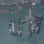
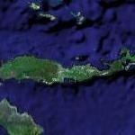
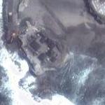
0: 2006-12-26 - Cement carrier M/V Sinar Andalas destroyed by the tsunami
Read more...
(report offensive)
Cement carrier M/V Sinar Andalas, with 19 crew, was in Indonesian Port of Lhok Nga when earthquake triggered a tsunami in 26 December 2004. The ship capsized with only four survivors.
Más sobre 2006-12-26 - Cement carrier M/V Sinar Andalas destroyed by the tsunami
1: Duri oil field
Read more...
(report offensive)
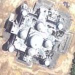
The Duri oilfield is one of the 141 oil fields operated in Sumatra , Indonesia by PT Caltex Pacific Indonesia under a production sharing contract with the Government of Indonesia. Discovered in 1941, the Duri field is one of the world's giant oilfields and the biggest steamflood operation located in the Rokan block with current oil production of 200,000 bpd (31,000 m 3 per day). The insitu formations of the Duri field are unconsolidated sands; coupled with a steam flood operation they are susceptible to producing large quantities of oily viscous fluids as a by-product from the oil production. Up to 400 m 3 /day (2,500 bpd) of oily viscous fluids are generated at five oil production Central Gathering Stations (CGS) in the Duri oilfield.
Más sobre Duri oil field
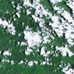
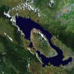
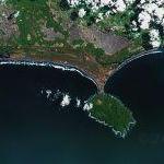
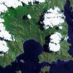
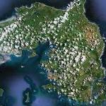
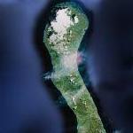
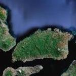
3: "Lost World" in New Guinea
Read more...
(report offensive)
Map centered on the highest area of the Mamberamo-Pegunungan Foja Reserves.
Más sobre "Lost World" in New Guinea
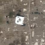
4: Situ Gintung Dam Collapse
Read more...
(report offensive)
Cirendeu district of southwest Jakarta.
Over 50 deaths so far in initial media reports.
Link below to News report.
Más sobre Situ Gintung Dam Collapse
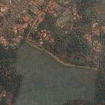
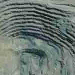
5: Sidoarjo Mud Flow
Read more...
(report offensive)
Location of Uncontrolled hot mud flow started by Natural Gas Drilling Well. Up to 1 million barrels per day. Has flowed into ocean via river just to the south. Pictures and map at link below.
Más sobre Sidoarjo Mud Flow
6: 2002-10-12 - Bali Bomb ground zero
Read more...
(report offensive)
The 2002 Bali bombing occurred on October 12, 2002 in the tourist district of Kuta on the Indonesian island of Bali. The attack was the deadliest act of terrorism in the history of Indonesia, killing 202 people, 164 of whom were foreign nationals (including 89 Australians), and 38 Indonesian citizens. A further 209 were injured.
The attack involved the detonation of three bombs: a backpack-mounted device carried by a suicide bomber; a large car bomb, both of which were detonated in or near popular nightclubs in Kuta; and a third much smaller device detonated outside the United States consulate in Denpasar, causing only minor damage.
Various members of Jemaah Islamiyah, a violent Islamist group, were convicted in relation to the bombings, including three individuals who were sentenced to death. Abu Bakar Bashir, the alleged spiritual leader of Jemaah Islamiyah, was found guilty of conspiracy, and sentenced to two and a half years imprisonment. Riduan Isamuddin, generally known as Hambali and the suspected former operational leader of Jemaah Islamiyah, is in U.S. custody in an undisclosed location, and has not been charged in relation to the bombing or any other crime.
Más sobre 2002-10-12 - Bali Bomb ground zero
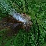
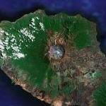
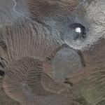
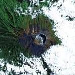
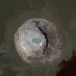
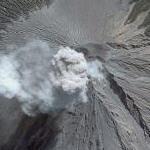
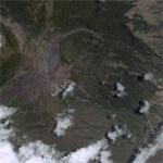
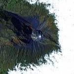
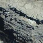
7: Tambora Volcano
Read more...
(report offensive)
Site of the famous 19th century eruption in Indonesia.
Más sobre Tambora Volcano
8: Child of Krakatoa

Read more...
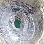
(report offensive)
The Remains of Krakatoa
This is a pretty good view of the little volcanic archipelago in the Sunda Strait between West Java and Sumatra, remaining from the 1883 explosive eruption of Krakatoa. The Indonesians refer to it as Anak Krakatau, which means child of Krakatoa.
(Link and Text credit to OldeClegg on Slashdot)
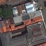
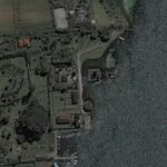
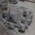
Más sobre Child of Krakatoa
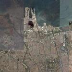
9: 2004-12-26 - Banda Aceh, Indonesia
Read more...
(report offensive)
city affected by Dec 26, 2004 tsunami
Más sobre 2004-12-26 - Banda Aceh, Indonesia
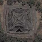
10: Borobudur
Read more...
(report offensive)
The brown blob at the center is Borobudur, the largest Buddhist monument in Asia: a cosmic mountain of stone covered in intricate stone carvings reminiscent of those at Angkor Wat. It is designed as a spiraling path for pilgrims, beginning at the base (now covered with earth to brace the pyramid) where scenes of the everyday give way to episodes from Buddha's life as you ascend. At the summit -- the purity of paradise is represented by increasingly simpler geometric shapes. All of this magnificence in a setting of lush jungle and multiple steaming volcanos! Climb to the top for a sunrise you will never forget.
Más sobre Borobudur
11: Pollution near Indonesia
Read more...
(report offensive)
Poor little Earth...
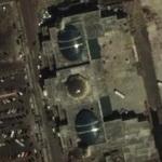
Más sobre Pollution near Indonesia
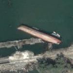
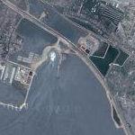
13: 2004-12-26 - Tugboat and barge thrown on the beach by tsunami

Read more...
(report offensive)
Más sobre 2004-12-26 - Tugboat and barge thrown on the beach by tsunami
14: Toba Volcano: The near Extinction of Mankind
Read more...
(report offensive)
75,000 years ago the eruption of Toba nearly wiped out Mankind.
Más sobre Toba Volcano: The near Extinction of Mankind
18: 2006-07-17 - Tsunami
Read more...
(report offensive)
Más sobre 2006-07-17 - Tsunami
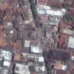
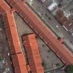
19: 2004-12-26 - Cement factory destroyed by tsunami
Read more...
(report offensive)
Cement factory destroyed by the tsunami of December 26 2004.
Más sobre 2004-12-26 - Cement factory destroyed by tsunami
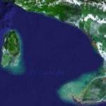
20: Sunda Strait
Read more...
(report offensive)
The Sunda Strait is the strait between the Indonesian islands of Java and Sumatra. It connects the Java Sea to the Indian Ocean. The name comes from the Indonesian term Pasundan, meaning "West Java.
The Battle of Sunda Strait was a naval battle which occurred during World War II. On the night of February 28 – March 1, 1942, the Australian cruiser HMAS Perth and the United States cruiser USS Houston faced a major Imperial Japanese Navy (IJN) task force. After a fierce battle of several hours duration, both Allied ships were sunk. Five Japanese ships were sunk by friendly fire, of which two were refloated.
Más sobre Sunda Strait
21: 2004-12-26 - Lhok Nga, town destroyed by the tsunami
Read more...
(report offensive)
Town destroyed by the December 2004 tsunami caused by the 2004 Indian Ocean earthquake, known by the scientific community as the Sumatra-Andaman earthquake. It was an undersea earthquake that occurred at 00:58:53 UTC (07:58:53 local time) on December 26, 2004. The magnitude of the earthquake was originally recorded as 9.0 (Richter scale), but has been upgraded to between 9.1 and 9.3. At this magnitude, it is the second largest earthquake ever recorded on a seismograph.
Más sobre 2004-12-26 - Lhok Nga, town destroyed by the tsunami
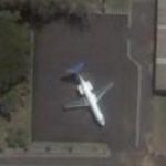
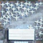
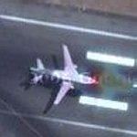
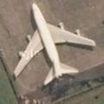
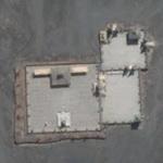
22: Airplane in a parking lot
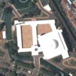
Read more...
(report offensive)
Perhaps a school or maybe a goverment training facility. Not the boat to the NE across the other side of the sports field too.
Más sobre Airplane in a parking lot
23: 2006-07-17 - Tsunami (Cipatujah coast)
Read more...
(report offensive)
Más sobre 2006-07-17 - Tsunami (Cipatujah coast)
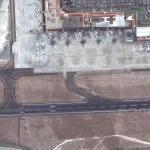
24: Bali-Denpasar - Ngurah Rai Airport (DPS/WADD)
Read more...
(report offensive)
Runway 1: Heading 09/27, 3,000m (9,842ft)
Más sobre Bali-Denpasar - Ngurah Rai Airport (DPS/WADD)
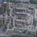
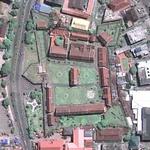
25: Kraton (Sultan's Palace of Yogyakarta)
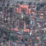
Read more...
(report offensive)
Más sobre Kraton (Sultan's Palace of Yogyakarta)
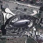
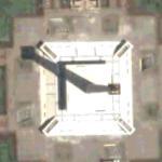
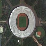
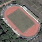
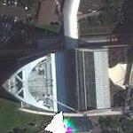
27: Gelora Bung Tomo Stadium
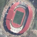
Read more...
(report offensive)
Más sobre Gelora Bung Tomo Stadium
28: Gunung Raung
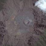
Read more...
(report offensive)
Raung Volcano in eastern Java.
Más sobre Gunung Raung
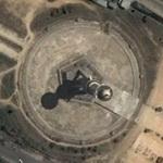
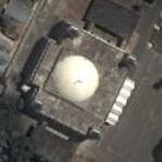
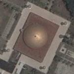
30: Indonesia's National Monument
Read more...
(report offensive)
Más sobre Indonesia's National Monument
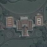
31: Gedung Agung (Yogyakarta Palace)
Read more...
(report offensive)
One of the Indonesian President official residences
Más sobre Gedung Agung (Yogyakarta Palace)
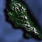
33: Flores Island: Tiny Hominids
Read more...
(report offensive)
Home to the small humans that lived only 18 thousand years ago.
Más sobre Flores Island: Tiny Hominids
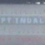
39: INDOSAT
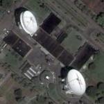
Read more...
(report offensive)
PT Indosat Tbk is an Indonesian telecommunications company was established in 1967 as a foreign investment company to provide international telecommunications services in Indonesia.
Más sobre INDOSAT
40: Komodo: Dragonskeep
Read more...
(report offensive)
Más sobre Komodo: Dragonskeep
42: Grasberg Mine
Read more...
(report offensive)
Largest Gold Mine in the world. Link below to more info.
Más sobre Grasberg Mine
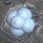
43: Sangeang Api
Read more...
(report offensive)
Sangeang Api (Gunung Api or Gunung Sangeang) is an active complex volcano on the island of Sangeang in Indonesia.
Más sobre Sangeang Api
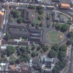
44: Taman Mini Indonesia Indah
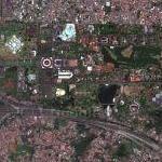
Read more...
(report offensive)
Taman Mini Indonesia Indah (TMII) or "Beautiful Indonesia Miniature Park" (literally translated) is a culture-based recreational area located in East Jakarta, Indonesia. It has an area of about 250 acres (1.0 km2). The park is a synopsis of Indonesian culture, with virtually all aspects of daily life in Indonesia's 26 (in 1975) provinces encapsulated in separate pavilions with the collections of architecture, clothing, dances and traditions are all depicted impeccably. Apart from that, there is a lake with a miniature of the archipelago in the middle of it, cable cars, museums, a theater called the Theatre of My Homeland (Theater Tanah Airku) and other recreational facilities which make TMII one of the most popular tourist destinations in the city.
Más sobre Taman Mini Indonesia Indah
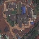
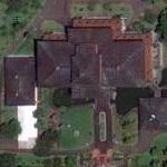
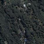
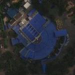
46: Nirwan Bakrie's House
Read more...
(report offensive)
This massive compound is owned by Nirwan Bakrie, Director of Bakrie & Brothers, a holding company for a variety of assets. His brother is Presidential candidate Aburizal Bakrie.
Más sobre Nirwan Bakrie's House
47: Gelora Bung Karno Stadium
Read more...
(report offensive)
The Gelora Bung Karno Main Stadium is a multi-use stadium in Senayan, Central Jakarta, Indonesia. It is named after Sukarno, Indonesia's first President. It is mostly used for football matches.
Más sobre Gelora Bung Karno Stadium
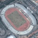
48: Delta Putra Stadium
Read more...
(report offensive)
The stadium has a capacity of 35,000 people, home of Deltras Sidoarjo.
Más sobre Delta Putra Stadium
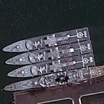
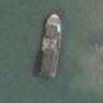
49: Parchim class corvette
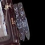
Read more...
(report offensive)
Más sobre Parchim class corvette
50: Wayang Windu Geothermal Power Station
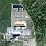
Read more...
(report offensive)
The Wayang Windu Geothermal Power Station is the largest geothermal power station in Indonesia. The facility utilizes two units, one with 110 MW and the other with 117 MW, totalling the installed capacity to 227 MW. The power station is located in Pangalengan, West Java, in Indonesia. An estimated cost of US$200 million was incurred in constructions and development.
Más sobre Wayang Windu Geothermal Power Station
51: "Amankila" by Ed Tuttle
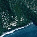
Read more...
(report offensive)
Amankila (meaning: "Peaceful hill") is a luxury coastal hotel situated on the green hill of Indrakila, near Manggis in Karangasem Regency in eastern Bali, Indonesia. It is operated by Aman Resorts and was opened in March 1992. Lonely Planet describes Amankila as "one of Bali's best resorts".
Más sobre "Amankila" by Ed Tuttle
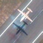
53: Plane plus ghost plane
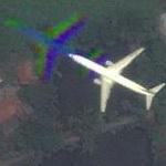
Read more...
(report offensive)
Más sobre Plane plus ghost plane
56: Kambangan Island
Read more...
(report offensive)
Kambangan (also Nusa Kambangan, Nusakambangan or Nusa Kembangan) island is located in the Indian Ocean, separated by a narrow strait off the southern coast of Java island; the closest port is Cilacap in Central Java province. Dubbed as the "Alcatraz of Indonesia", the island is notorious for its maximum security prisons, home to convicted murderers, terrorists, drug dealers and those convicted in high profile corruption cases.
Más sobre Kambangan Island
57: Indonesia Museum
Read more...
(report offensive)
The Indonesia Museum (Indonesian: Museum Indonesia), is an anthropology and ethnological museum located in Taman Mini Indonesia Indah (TMII), Jakarta, Indonesia. The museum concentrated on arts and cultures of various ethnic groups that inhabit Indonesian archipelago and formed the modern nation of Indonesia. The museum is a richly decorated building in Balinese architecture, it houses traditional and contemporary arts, crafts and traditional costumes from the different regions of the nation.
Más sobre Indonesia Museum
58: Bintan Island
Read more...
(report offensive)
Bintan Island or Negeri Segantang Lada is an island in the Riau archipelago of Indonesia. It is part of the Riau Islands province, the capital of which, Tanjung Pinang, lies in the island's south and is the island's main community.
Bintan's land area is 2,402.28 square kilometres (927.53 sq mi) (total area is 60,057 square kilometres (23,188 sq mi) including 96% sea area). Its administrative region is designated the Bintan Island Regency, one of the six administrative regions of the Riau Islands province. The city of Tanjung Pinang is an autonomous area within the Bintan Island.
Bintan's history is traced to the early 3rd century. The island flourished as a trading post on the route between China and India, and over the centuries it came under the control of the Chinese, the British, and then the Dutch when it was declared part of the Dutch East Indies through the Anglo-Dutch Treaty of 1824. In the 12th century, the Bintan island in the Strait of Malacca was known as the "Pirate Island" since the Malay pirates used to loot trading ships sailing in these waters.
Más sobre Bintan Island
60: Take off from Surabaja
Read more...
(report offensive)
Más sobre Take off from Surabaja
61: Raya Baiturrahman Mosque
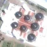
Read more...
(report offensive)
Más sobre Raya Baiturrahman Mosque
62: Purna Bhakti Pertiwi Museum
Read more...
(report offensive)
The Purna Bhakti Pertiwi Museum, is a history museum specialized on the life of Suharto, the former second president of Indonesia and a powerful political figure in modern Indonesian history. It is located in Taman Mini Indonesia Indah (TMII), Jakarta, Indonesia. The museum houses and displays the large amount of Suharto's collections; mostly valuable objects, artworks and souvenirs, received from various world leaders and Indonesian people, accumulated during the 32 years of his administration in Indonesia. The museum is a modern building with design took shape of tumpeng, a traditional Javanese cone-shaped rice, symbolized gratitude.
Más sobre Purna Bhakti Pertiwi Museum
63: Ambon Island
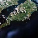
Read more...
(report offensive)
Ambon Island is part of the Maluku Islands of Indonesia. The island has an area of 775 km2 (299 sq mi), and is mountainous, well watered, and fertile. It is the main island of the South Moluccas. The main city and seaport is Ambon (1990 pop. 275,888), which is also the capital of Maluku province. Ambon has an airport, and is home to the Pattimura University, a state university, and a few private universities.
Más sobre Ambon Island
64: Toraja Heritage Hotel
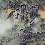
Read more...
(report offensive)
Más sobre Toraja Heritage Hotel
68: Jakarta History Museum
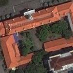
Read more...
(report offensive)
The Jakarta History Museum (Indonesian: Museum Sejarah Jakarta), which is also known as Fatahillah Museum or Batavia Museum, is located in the Old Town of Jakarta, Indonesia. The building was built in 1710 as the Stadhuis (city hall) of Batavia. Jakarta History Museum, opened in 1974, displays objects from the prehistoric times of the city, the founding of Jayakarta in 1527, and through Dutch colonization from the 16th century onwards until Indonesia’s Independence in 1945.
Más sobre Jakarta History Museum
69: Wayang Museum
Read more...
(report offensive)
The Wayang Museum (Indonesian: Museum Wayang) is a museum dedicated to Javanese wayang puppetry.
Más sobre Wayang Museum
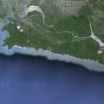
70: Sangir Island
Read more...
(report offensive)
Sangir Besar, commonly called Sangir Island (with the spelling variants "Sangihe", "Sanghir" or "Sangi"), is an island in the Sangir Islands group. Its Indonesian name literally means "Great Sangir", in reference to the fact that it is the archipelago's main island. Politically, it is part of North Sulawesi province, Indonesia. The main language is the Sangir language.
It was the scene of the violent eruption of Gunung Awu volcano in March, 1856. The existing mountain was reshaped by the eruption, and flooding was extensive. The death toll was estimated to exceed two thousand, maybe as high as 6,000. While this appears to have been the most devastating eruption on record, is was not the only one - the last major eruption was in 1966, and the last significant one as recently as 2004.
Más sobre Sangir Island
71: Bumi Sriwijaya Stadium
Read more...
(report offensive)
Más sobre Bumi Sriwijaya Stadium
73: Batu Hijau Copper Gold Mine
Read more...
(report offensive)
Newmont Mining.
Link below for more info.
Más sobre Batu Hijau Copper Gold Mine
74: Babi Island
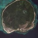
Read more...
(report offensive)
Babi Island (Indonesian: Pulau Babi, literally Pig Island) is an island located off the coast of Flores, East Nusa Tenggara. The 1992 Flores earthquake and resulting tsunamis are estimated to have killed 263 to 700 residents of the island, with most of the destruction on the southern end of the island.
Más sobre Babi Island
75: Fine Art and Ceramic Museum
Read more...
(report offensive)
The Fine Art and Ceramic Museum (Indonesian: Museum Seni Rupa dan Keramik is a museum in Jakarta, Indonesia. The museum is dedicated especially to the display of traditional fine art and ceramics of Indonesia.
Más sobre Fine Art and Ceramic Museum
78: Maritime Museum
Read more...
(report offensive)
The Maritime Museum (Indonesian: Museum Bahari) is located in the old Sunda Kelapa harbor area in Penjaringan Administrative Village, Penjaringan Subdistrict, Jakarta, Indonesia. The museum was inaugurated inside the former Dutch East India Company warehouses. The museum focuses on the maritime history of Indonesia and the importance of the sea to the economy of present-day Indonesia.
The museum displays models of fishing boats and other maritime objects from different parts of Indonesia. The museum also exhibits the celebrated Pinisi schooners of the Bugis people of South Sulawesi, which at present make up one of the last sea-going sailing fleets in the world.
Más sobre Maritime Museum
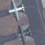
79: Tupolev Tu-16

Read more...
(report offensive)
Museum Dirgantara Mandala
http://imogiri.tripod.com/index.html
Más sobre Tupolev Tu-16
80: Sultan Iskandar Muda Airport
Read more...
(report offensive)
Más sobre Sultan Iskandar Muda Airport
82: McDonnell Douglas DC-9-32

Read more...
(report offensive)
Más sobre McDonnell Douglas DC-9-32
83: Puncak Jaya (highest point of Oceania)
Read more...
(report offensive)
Puncak Jaya (pronounced [?punt?a? ?d?aja]), sometimes called Mount Carstensz or the Carstensz Pyramid (/?k?rst?nz/), is a mountain in the Sudirman Range, the western central highlands of Papua province, Indonesia (within Puncak Jaya Regency). Other names include Nemangkawi in the Amungkal language, Ngga Pulu, Carstensz Toppen and Gunung Sukarno.
Más sobre Puncak Jaya (highest point of Oceania)
85: Sipura
Read more...
(report offensive)
Sipura, or Sipora located off Sumatra in Indonesia, is the smallest and most developed of the four Mentawai Islands at only 845 km². The regency capital of the Mentawai Islands, Tua Pejat, is found on Sipora. An estimated 10-15% of the original rainforest remains on this island.
Sipora is a surfing destination. Surf spots Hollow Trees and Lance's Left break off the southern end of the island. Surf spots break in the northwestern region of this island including Telescopes, Iceland, and Scarecrows. The ocean swells are most consistent from April to October, but Sipora is a viable year-round surfing destination. Wind conditions can vary by the hour, and are often calm and glassy. For accommodation near Sipura, most surfers stay on yachts that can be chartered in Padang and motor between surf breaks as conditions change. Some visiting surfers choose to stay on the island itself at resorts or with local families in Tua Pajet.
The islands North Pagai (Pagai Utara) and South Pagai (Pagai Selatan) are situated to the south, and also have surf breaks along their western coasts.
Más sobre Sipura
86: Pontianak Equatorial Monument
Read more...
(report offensive)
Más sobre Pontianak Equatorial Monument
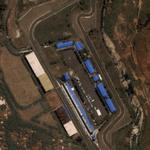
89: Sentul International Circuit
Read more...
(report offensive)
Más sobre Sentul International Circuit
91: Sultan Suriansyah Mosque
Read more...
(report offensive)
Más sobre Sultan Suriansyah Mosque
92: Wisma 46 (tallest building in Indonesia)
Read more...
(report offensive)
By Zeidler Partnership Architects and DP Architects Pte Ltd
Más sobre Wisma 46 (tallest building in Indonesia)
94: Singkep
Read more...
(report offensive)
Singkep is an island in the Lingga Archipelago in Indonesia. Its area is 757 square kilometres (292 sq mi). It is separated from the east coast of Sumatra by the Berhala Strait. It is surrounded by islands P. Posik to the west, P. Serak to the SW, P. Lalang to the South, and P. Selayar of Riau Islands between Lingga and Singkep.
Más sobre Singkep
95: Adonara
Read more...
(report offensive)
Adonara is an island in the Lesser Sunda Islands of Indonesia, located east of the larger island of Flores in the Solor Archipelago. To the east lies Lomblen. It is the highest of the islands of the archipelago, at 1659 metres, and has an area of 497 km2.[1] It is in the East Nusa Tenggara province.
Más sobre Adonara
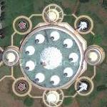
96: Agung Al Kaudzar Mosque
Read more...
(report offensive)
Más sobre Agung Al Kaudzar Mosque
97: Banjarmasin Grand Mosque
Read more...
(report offensive)
Más sobre Banjarmasin Grand Mosque
98: Aek Godang Airport (AEG)
Read more...
(report offensive)
Más sobre Aek Godang Airport (AEG)