Lugares de interés (POIs) del Mapa
0: Preparing for the 2009 Gyre Expedition

 Pacific Gyre Expedition 2009 Voyage #1
The quantity of plastic pollution in the ocean is increasing rapidly, paralleling the rapid rise in global plastic production. Each time the ORV Alguita crew collects samples from the North Pacific Subtropical Gyre, we find that the abundance of plastic has increased since our previous visit. In previous research voyages we have found a very high abundance of plastic in the area of the gyre that has come to be known as "The Eastern Pacific Garbage Patch", but we suspect that the contamination is much more widespread. This summer we will have the opportunity to test this hypothesis during the first voyage of our four month research expedition. During this voyage the ORV Alguita research crew will be at sea for over six weeks as they sail west from California past the Northern Hawaiian Islands as far as the International Date Line (180 degrees longitude) to sample areas of the Pacific Ocean previously un-sampled for plastic marine debris. We will be collecting samples of plastic debris, plankton and fish to analyze back in our laboratory to better understand not only the quantity of plastic debris pollution in remote areas of the ocean, but also the impacts the plastic is having as it is consumed by marine animals. Below is a map that shows the area where ORV Alguita has sampled for plastic pollution over the past 10 years. The first voyage of the summer expedition hopes to extend the study area all the way to the International Date Line at 180 degrees longitude.
Pacific Gyre Expedition 2009 Voyage #1
The quantity of plastic pollution in the ocean is increasing rapidly, paralleling the rapid rise in global plastic production. Each time the ORV Alguita crew collects samples from the North Pacific Subtropical Gyre, we find that the abundance of plastic has increased since our previous visit. In previous research voyages we have found a very high abundance of plastic in the area of the gyre that has come to be known as "The Eastern Pacific Garbage Patch", but we suspect that the contamination is much more widespread. This summer we will have the opportunity to test this hypothesis during the first voyage of our four month research expedition. During this voyage the ORV Alguita research crew will be at sea for over six weeks as they sail west from California past the Northern Hawaiian Islands as far as the International Date Line (180 degrees longitude) to sample areas of the Pacific Ocean previously un-sampled for plastic marine debris. We will be collecting samples of plastic debris, plankton and fish to analyze back in our laboratory to better understand not only the quantity of plastic debris pollution in remote areas of the ocean, but also the impacts the plastic is having as it is consumed by marine animals. Below is a map that shows the area where ORV Alguita has sampled for plastic pollution over the past 10 years. The first voyage of the summer expedition hopes to extend the study area all the way to the International Date Line at 180 degrees longitude.
 Meet the Crew!
Get to know the six dedicated crew members that will be corresponding with you during the upcoming voyage. Find out about how they got involved in oceanographic research, and why they are willing to leave land for six weeks to study plastic marine debris in remote areas of the Pacific Ocean. Click here to read more http://orvalguita.googlepages.com/meetthecrew!
Meet the Crew!
Get to know the six dedicated crew members that will be corresponding with you during the upcoming voyage. Find out about how they got involved in oceanographic research, and why they are willing to leave land for six weeks to study plastic marine debris in remote areas of the Pacific Ocean. Click here to read more http://orvalguita.googlepages.com/meetthecrew!
 If you would like to post a comment or question to the crew click here!
Más sobre Preparing for the 2009 Gyre Expedition
1: Bon Voyage ORV Alguita!
 ORV Alguita has just departed on the first voyage of the 2009 Pacific Gyre Expedition!

Más sobre Bon Voyage ORV Alguita!
2: Day 2

Day 2
Noon Position: 31°49'26.40"N, 119°20'42.00"W Hi Students, Thanks for all of the fantastic questions and comments you have sent our way! Today is our first full day at sea and the crew is still getting used to the swing of things. Only one case of sea-sickness so far, and we’ve spotted some pretty cool wildlife. This morning we spotted four Fin Whales roughly 100 yards of the starboard stern of the vessel, and one more whale who was a little too far from the boat for us to identify. Many of you are wondering the same question: what are we going to eat? The Alguiita is full any kind of food you can imagine. Last night the crew had stuffed mushroom and a fresh green salad. This morning we woke up to a homegrown boysenberry cobbler cooking in the oven. As many of you saw at the send-off, the deck is full of delicious fresh produce; we have everything from kale to chocolate persimmons to snack on. -Nicole-Day 2 (click here to read more)
Más sobre Day 2
3: Day 3 Dolphins and Debris
Day 3- Dolphins and debris
Greetings from the ORV Alguita! In the past 24hrs, we have had our first series of debris encounters. While taking in our fishing lines for the night, we dragged in our first piece of debris; a deflated green balloon with the string still attached. It was a little disheartening to discover that we were fishing for trash instead of fish. Last night at around 10pm, we passed the Exclusive Economic Zone (EEZ). For those of you who are wondering what that means, we are now officially out of the US waters, in what is essentially the no-man’s land of the Pacific. Because this area is out of US jurisdiction, it is not a top priority in terms of government funded research. We were greeted in the morning with another debris sighting. We found a plastic water bottle (see photo above) which likely originated from Russia (the cap had Russian text). It had been afloat in the ocean just long enough for fouling organisms (i.e. tiny baby gooseneck barnacles) to latch on.
 Our next trash sighting, roughly 300miles out to sea, was a tangle of fouled line and buoys. In addition to gooseneck barnacles making their home inside the floating mess, we found several pelagic crabs and a couple of different invertebrates. After weighing the mass of rubbish (9 kilos) we preserved a sample of the debris with the critters that we found living on it for Miriam Goldstein, a doctoral candidate at SCRIPPS, who is studying the fouling organisms that live on pelagic trash. The last two pieces of trash found today were a Monarch brand garlic-salt container and a plastic napkin or towel floating on the surface. These finds are indicators that we are making our way into the heart of trash accumulation.
As far as wildlife sightings go, we had a pod of Common Dolphins passing us on portside (see photo above). We also spotted several Velella velella, also known as the By-the-wind sailors, which is an awesome little sea creature that has a small oval sail so it can use the winds to travel the seas.
Best Wishes from the Captain and crew
Cheers,
Nicole
Our next trash sighting, roughly 300miles out to sea, was a tangle of fouled line and buoys. In addition to gooseneck barnacles making their home inside the floating mess, we found several pelagic crabs and a couple of different invertebrates. After weighing the mass of rubbish (9 kilos) we preserved a sample of the debris with the critters that we found living on it for Miriam Goldstein, a doctoral candidate at SCRIPPS, who is studying the fouling organisms that live on pelagic trash. The last two pieces of trash found today were a Monarch brand garlic-salt container and a plastic napkin or towel floating on the surface. These finds are indicators that we are making our way into the heart of trash accumulation.
As far as wildlife sightings go, we had a pod of Common Dolphins passing us on portside (see photo above). We also spotted several Velella velella, also known as the By-the-wind sailors, which is an awesome little sea creature that has a small oval sail so it can use the winds to travel the seas.
Best Wishes from the Captain and crew
Cheers,
Nicole
Más sobre Day 3 Dolphins and Debris
4: Day 4- First open ocean swim!
 Noon Position: 29°12'28.80"N 124°56'13.20"W
Day 4- first open ocean swim!
 Can anyone identify the animal in the photo above? (Hint: Check out the links on day 3!)
 Más sobre Day 4- First open ocean swim!
5: Day 5

Day 5
Hey guys, the ORV Alguita team needs your help!Most of the debris we have captured from the ocean has contained barnacles and crabs. All we know about the crabs is that they are pelagic (which means they spend their life floating throughout the open ocean). Can anyone help us find the name of the pelagic crab in the picture Above? Today is day 5 at sea, all is well and the crew is in great spirits. Now that the all of the crew is up to speed with watch duties, we have switched to 2 hour, single watches. This is a lot easier on our sleep schedules. There is however news to report regarding our travel plans. Due to a large and persistent high pressure system, we have to rethink our original route, which would have deposited us along the International Dateline (180W) at latitude of about 35N. Because of the high pressure system we are dealing with light winds, which is not optimal for sailing. The weather has forced us to spend most of our time underway motor sailing. We have already used roughly 200 gallons of the 700 gallons we started with? If we keep up at this rate we will exhaust our fuel supply. At this point we are forced to bend to the will of nature and follow the winds. As is required when dealing with the seas, the Captain has a backup plan. Our new route and sampling strategy will take us to a more southerly location than planned, but will still present us with ample research opportunities. The new plan is to continue our heading south in order to catch the easterly trade winds. This route will bring us to Hawai’i and allow us to survey a debris convergence zone located off the southern tip of the Big Island. This convergence zone is thought to be responsible for the accumulation of debris on beaches such as Kamilo. After sampling this convergence zone, we can refuel and head up the island chain toward the International Dateline at a lower latitude than planned. How far we will actually get is to be determined by the amount of time it takes us to get to Hawai’i in the light winds we have been experiencing since we left. Speaking of debris sampling, today’s debris catch was a 300mm buoy fouled with barnacles and pelagic crabs. (See photo of Captain Moore on left.)
Keeping in tune with the rest of the weekend, the weather was phenomenal. Much of the day was spent out on deck stretching our limbs and taken in the scenery (which is mainly….water). Capt. Moore gave a presentation to an assembly of 14-18 year old students at Hawai’i Preperatory Academy. He was able to lead them through a power point presentation via satellite phone.
Our wildlife sighting for the day included a Red tailed Tropic Bird and some Petrels.
Speaking of debris sampling, today’s debris catch was a 300mm buoy fouled with barnacles and pelagic crabs. (See photo of Captain Moore on left.)
Keeping in tune with the rest of the weekend, the weather was phenomenal. Much of the day was spent out on deck stretching our limbs and taken in the scenery (which is mainly….water). Capt. Moore gave a presentation to an assembly of 14-18 year old students at Hawai’i Preperatory Academy. He was able to lead them through a power point presentation via satellite phone.
Our wildlife sighting for the day included a Red tailed Tropic Bird and some Petrels.
 If you would like to see more about what our home on the research vessel is like here is a link to a video and slide-show tour of ORV Alguita http://orvalguita.googlepages.com/touroforvalguita
Más sobre Day 5
6: Day 6- First manta trawl!
 Noon position: 24°52'40.80"N 128° 9'57.60"W
Day 6- First manta trawl!
It’s Day six and we are officially 2/5 of the way to Hawai’i. Day six has been a day of firsts-- the first plastic trawl of the trip, and our first fish catch (a Mahi Mahi!). Let’s start with the trawls. While the winds have been against us in terms of maintaining our original course, they have put us in an area of the Pacific which had never been sampled……until today! See the map below or Click here, to view more maps of our previous sampling areas. We deployed the first Manta trawl, a device that captures surface debris in a fine mesh net, at 9am. This process was akin to riding a bike for the Captain and veteran crew Drew, Joel and Jeff, and a learning experience for the newbies (Christiana and myself).
After an hour of towing the trawl we pulled it in to find a strikingly low amount of plastic. Among the plastic identified was some line, a few hard plastic fragments, and a piece of a clear plastic label on which we could decipher the letter “d”. Among the life identified in the sample was a button valella, some copepods, a juvenile Pacific saury, and tiny gastropods with gorgeous purple shells. (See image of sample at the top of this message.)
The evening brought on trawl number two. This trawl gave us the opportunity to experiment with a tethered underwater camera, which Joel was able to rig to record the underwater flow into the Manta trawl. This was a significant in that it confirmed the integrity of our surface sampling methods. We ran the evening trawl for an hour as well, finding results similar to the morning trawl--very little plastic.
Obviously the low quantity of plastic present in samples is good news, but it does highlight a key point. Throughout fifteen years of sampling, we have yet to bring in a trawl completely void of plastic. While standing on the foredeck today, the Captain was able to identify plastic fragments flowing past the vessel. We also spotted some larger debris, a 5 gallon bucket which managed to evade our collection efforts. The point is, even in this new sample area in which our trawls our producing comparatively low amounts of plastic-there is still enough debris present for us to visually register and in our trawls. The relatively low amount of plastic also points to the possible delineation of the boundaries of an accumulation zone, although it is far too early in the data collection process to make any definitive conclusions. Joel noted that during the JUNKraft expedition last summer he and Marcus Eriksen noted a similar trend in abrupt transitions in plastic accumulation as they skirted the south edge of the accumulation area.
And finally, after five days of rigging fishing poles and hand lines, we had our first catch. Christiana kept the liver and other organs and tissue for future analysis.
Best wishes from the Capt. and Crew
We deployed the first Manta trawl, a device that captures surface debris in a fine mesh net, at 9am. This process was akin to riding a bike for the Captain and veteran crew Drew, Joel and Jeff, and a learning experience for the newbies (Christiana and myself).
After an hour of towing the trawl we pulled it in to find a strikingly low amount of plastic. Among the plastic identified was some line, a few hard plastic fragments, and a piece of a clear plastic label on which we could decipher the letter “d”. Among the life identified in the sample was a button valella, some copepods, a juvenile Pacific saury, and tiny gastropods with gorgeous purple shells. (See image of sample at the top of this message.)
The evening brought on trawl number two. This trawl gave us the opportunity to experiment with a tethered underwater camera, which Joel was able to rig to record the underwater flow into the Manta trawl. This was a significant in that it confirmed the integrity of our surface sampling methods. We ran the evening trawl for an hour as well, finding results similar to the morning trawl--very little plastic.
Obviously the low quantity of plastic present in samples is good news, but it does highlight a key point. Throughout fifteen years of sampling, we have yet to bring in a trawl completely void of plastic. While standing on the foredeck today, the Captain was able to identify plastic fragments flowing past the vessel. We also spotted some larger debris, a 5 gallon bucket which managed to evade our collection efforts. The point is, even in this new sample area in which our trawls our producing comparatively low amounts of plastic-there is still enough debris present for us to visually register and in our trawls. The relatively low amount of plastic also points to the possible delineation of the boundaries of an accumulation zone, although it is far too early in the data collection process to make any definitive conclusions. Joel noted that during the JUNKraft expedition last summer he and Marcus Eriksen noted a similar trend in abrupt transitions in plastic accumulation as they skirted the south edge of the accumulation area.
And finally, after five days of rigging fishing poles and hand lines, we had our first catch. Christiana kept the liver and other organs and tissue for future analysis.
Best wishes from the Capt. and Crew
Más sobre Day 6- First manta trawl!
7: Day 7

Day 7
Hello from the Capt. and crew! We are still headed for Hawai’I, but have added a slight detour to the northwest of our route. Dave Foley, an oceanographer with NOAA, has predicted an accumulation zone not too far out of our way and we are headed there to investigate. You may be wondering, “where is he getting the idea that marine debris might be accumulating in this area?” Well, Dave has put together the Debris Estimation Likelihood Index (DELI) based off of chlorophyll levels. Essentially high levels of chlorophyll correlate to high levels of plankton. Plankton rides the ocean currents, as does marine debris. So it is hypothesized that where the currents have caused an accumulation of plankton, there might also be an accumulation of debris. We deployed the third Manta trawl of the trip this afternoon. The trawl produced lots of juvenile sawrys, some more of the purple gastropods which Capt. Moore has identified as Janthina janthina, and to our disgust, but not to our surprise, several plastic fragments and some plastic line. After trawling we practiced how to heave-to, which is a way to set the sails that effectively stops the boat from moving forward. This is an important tool to have under our belt in the case of an emergency. Since we were already stopped from the heave-to drill, the Captain, Christiana, Drew and Jeff decided to take a dip in the ocean. Capt. Moore searched for trash while Drew captured underwater footage of the debris gathering. They pulled up a piece of a plastic shopping bag, a newspaper packing band, and some plastic fragments. This is what happens when throwaway consumerism meets the open ocean. The winds are starting to pick up and the seas are beginning to get a little feistier. Some of us are reapplying our scopolamine patches, and others have sea legs (and stomachs) just as sturdy as ever. The day ended with a valuable lesson (at least for me): don’t leave the hatches open. As you can imagine, hatches and active seas don’t mix very well. I experienced this first hand today as a large wave swept over the deck and down the hatch located DIRECTLY above my head. Needless to say, I was jostled from my pre-watch nap with seawater to the face and left with a pile of wet sheets. We are cruising along at a speed of 9.0knotts and climbing; the fastest we’ve seen yet…and we are achieving it without the help of our engines!Más sobre Day 7
8: Day 8 and 9

Day 8 and 9
Flying kites, flying squid, flying fish, and a pirate ship (well not really)… We’ve been sailing downwind with a big sail called the "spinnaker" (or in sailing terms "flying the kite") for the past two days. Downwind sailing is wonderfully calm (even in 20 knot winds) and the spinnaker is really is like a giant kite.Más sobre Day 8 and 9
9: Day 10 and 11

Day 10 and 11
Midday presented several of us with the opportunity sit up on the foredeck and catch some rays. In between flipping pages we’d take in the sights of the gyre, sometimes Albatross and flying fish, other times flotsam such as lotion bottles (see picture to left.) “We did have a bit of craziness on deck today, when we accidentally snagged an Albatross with one of our trolling fishing lures. I was filming the graceful bird swooping over the waves when it landed right in the path of one of our fishing rigs. Well, before we knew it the poor bird was snagged and being dragged across the ocean, unable to regain control. With some quick thinking, we reeled the bird up to the boat where Joel took control of this very awkward animal. He has spent time in the Northwest Hawaiian Islands so he has had experience in handling Albatross. The good news is the line was the only thing snagging the wing--not the hook. So with a freed wing and some feathers in need of a little primping, we let her go back onto the big blue and watched as she stretched her wings out and prepared for flight a flight back home…only 1000 miles away. Amazing birds they are…fly thousands of miles to feed in the open ocean.”
Our encounter with Billy was a harsh reminder for us all; we leave our footprint where ever we go. It is important for us to be acutely aware of our actions to keep from inadvertently harming earth’s flora and fauna.
“We did have a bit of craziness on deck today, when we accidentally snagged an Albatross with one of our trolling fishing lures. I was filming the graceful bird swooping over the waves when it landed right in the path of one of our fishing rigs. Well, before we knew it the poor bird was snagged and being dragged across the ocean, unable to regain control. With some quick thinking, we reeled the bird up to the boat where Joel took control of this very awkward animal. He has spent time in the Northwest Hawaiian Islands so he has had experience in handling Albatross. The good news is the line was the only thing snagging the wing--not the hook. So with a freed wing and some feathers in need of a little primping, we let her go back onto the big blue and watched as she stretched her wings out and prepared for flight a flight back home…only 1000 miles away. Amazing birds they are…fly thousands of miles to feed in the open ocean.”
Our encounter with Billy was a harsh reminder for us all; we leave our footprint where ever we go. It is important for us to be acutely aware of our actions to keep from inadvertently harming earth’s flora and fauna.
 Today, with roughly 1900 miles under our belt, we reached the outskirts of the accumulation zone we’ve been aiming for. The early morning was spent fine tuning the Bongo nets and Manta trawl for 24 straight hours of sampling over a 80 nautical mile transect. Why the continuous sampling? Well Dr. Nikolai Maximenko, with the School of Ocean and Earth Science Technology (SOEST) in Hawai’i is interested in meso-scale variations across this predicted accumulation zone. Basically, he wants to see if a debris gradient can be established from the boundary to the actual accumulation zone. So, as I mentioned before we are sampling, within, and outside the boundaries. We are running trawls for 2 hours, collecting the samples, and then redeploying them.
 By 10am all hands were on deck and the sampling marathon began. It’s going to be a long, yet fruitfull night. With a sea state ranging from 5-6 on the Beaufort scale, conditions have not been ideal for sampling, but we are working through it. The swells are the largest we’ve seen all trip. They are awe inducing, especially when they are positioned to crash right over the deck.
Coming from a first timer to the gyre, the samples we collect are truly astounding. In one regard it is amazing to have the opportunity to get up close and personal with planktonic organisms we catch while trawling. Today we caught several Portuguese Man-of -Wars, which are mesmerizing little critters. On the flip side, it is disturbing to watch chunks of debris spill out of the nets. It is bizarre and unsettling to find the detritus of our haphazard consumer lifestyle in one of the most remote parts of the world.
From the cutting edge of marine debris research,
Nicole
By 10am all hands were on deck and the sampling marathon began. It’s going to be a long, yet fruitfull night. With a sea state ranging from 5-6 on the Beaufort scale, conditions have not been ideal for sampling, but we are working through it. The swells are the largest we’ve seen all trip. They are awe inducing, especially when they are positioned to crash right over the deck.
Coming from a first timer to the gyre, the samples we collect are truly astounding. In one regard it is amazing to have the opportunity to get up close and personal with planktonic organisms we catch while trawling. Today we caught several Portuguese Man-of -Wars, which are mesmerizing little critters. On the flip side, it is disturbing to watch chunks of debris spill out of the nets. It is bizarre and unsettling to find the detritus of our haphazard consumer lifestyle in one of the most remote parts of the world.
From the cutting edge of marine debris research,
Nicole
Más sobre Day 10 and 11
10: Day 13

Day 13- Plastic in a mahi mahi
June 22, 2009 Chrisitana and Jeff each reeled in a mahi mahi today, one right after the other. The fish served a double purpose, science and sustenance. Before we filleted the fish, Christiana took muscle and liver samples of each of the fish and looked in their stomachs. Fish number 3, the mahi mahi that Jeff reeled in, contained what the Captain confirmed via microscope as a piece of plastic film. This now makes 8 species of fish in which we have identified with plastic in their gut. The last set of trawls came in at 5pm. It was a productive, though hectic, sampling marathon. Although the samples have yet to be thoroughly analyzed, we were able to spot differing densities of plastic within and outside of the boundaries of the plankton (and possibly debris) accumulation zone. At the end of a long stint of sampling and a significant find of plastic in a common food fish, the Captain prepared one of his specialties chili rellenos accompanied by rice, beans, fresh guacamole, and fresh salsa. It was a perfect end to a productive day. We are now en route to Hawai’I with aboiut 400 miles to go. Stay tuned for more updates and be sure to check out the Scientific American website in the “60 second science blog”, where Drew ‘s weekly account of our voyage is posted. ANSWERS TO STUDENT QUESTIONS Regarding the question to Joel about the JUNKraft from State Street Elementary: "I built and sailed the JUNK Raft with Marcus Eriksen who had built a bottle boat and floated down the Mississppi River a few years ago. We thought that building an ocean going bottle raft and sailing it from Long Beach to Hawaii would be a great way to bring attention to the problem of plastic pollution in our oceans . Your right unfortunately birds are sometimes caught in fishing gear. Part of the federal government called the National Marine Fisheries Service helps fishermen design fishing gear that minimizes the number of birds that get caught. Sometimes I do get seasick. I’m taking medicine while on the ORV Alguita that keeps me from getting too sick. On the JUNK raft I didn’t have to take any medicine because the JUNK was so slow and steady." Joel Paschal- ORV Alguita CrewMás sobre Day 13
11: Day 14

Day 14- More Mahi
July 23, 2009 Our resident Ichthyologist, Christiana Boerger’s, account of the day: Today we hooked 3 Mahi Mahi! This puts our total fish catch up to 7. Mahi Mahi (Coryphaena hippurus) are also referred to as Dorado or Dolphinfish. They put up a great fight when you reel them in, actually jumping out of the water. When we catch the fish, I dissect them to look for plastic in their stomach and save samples of tissue to analyze for POPs (persistent organic pollutants) later in the lab. The dissections were particularly interesting today! I go through some simple steps to get the samples I need. First, I record the time and location of where the fish were caught. Then I take some simple measurements, standard length (the length from the tip of the closed mouth to the end of the caudal peduncle) and weight. Next comes the fun part for me, opening them up! I carefully take scissors and cut from their natural opening (anus) to the bone located in between the pelvic fins. I carefully cut out the liver and place it on a piece of tin foil which will be frozen until it can be looked at back at a lab for toxin analysis. I check out the gonads to reconfirm the sex of the fish. These are all females but none of them have had developed eggs yet. Next I remove the stomach. I make another cut to open up the stomach completely to take a look around. The last thing I do is take a muscle tissue sample of each of the fish, which is frozen along with the liver. No plastic in the stomachs today, however, in the first Mahi, there were 3 whole fish in its stomach. I identified them to be some sort of puffer fish. You could still feel the spikes on the skin. The second Mahi had a less digested pufferfish. I was actually able to pull out the stomach of this pufferfish and found its last meal to be crustaceans (probably crabs). I found some more bones in Mahi #2’s stomach, which I identified to be from a flying fish, due to its super long pectoral fins. The third Mahi had an empty stomach, except for a couple different types of parasites which were still moving around. We have caught small flying fish in some of our trawling nets and I am very interested to see if I will find any plastic in their stomach’s, seeing as I now know they are a part of the Mahi’s diet. So exciting from a research perspective!! Needless to say, we’ve got enough Mahi to eat for days, and Joel has made some Mahi jerky, Jeff made some Mahi poke, and the Captain is preparing a dinner tonight of what else, but Mahi sushi rolls and sashimi!! The ORV Alguita Fish Nerd, ChristianaMás sobre Day 14
12: Day 15

Day 15
Day 15 began with sunshine, a sail change, and a blue water expedition. After breakfast, the crew rallied to take down the sails in preparation for the blue water expedition. Here is the Captain’s account of the morning: “This was the first dive in the outer waters of the Gyre for "Scuba Drew" Wheeler, a veteran of our 2002 Gyre voyage. As we were tanking up for our dive, I saw a dish soap bottle astern that had been afloat for some time. I jumped in with mask and snorkel and saw that birds had pecked a few quarter size holes in this bottle, the shape of your smaller Joy or Dawn bottle, and inside was a condominium for a colony of sea life, including crabs and fish. After filming this, a larger school of fish around a black plastic bag's tangled remains, and retrieving a handful of miscellaneous ropes and line balls and other plastic fragments floating by, Drew remarked that this collection of trash in a few minutes was as bad as it was in the center of the accumulation zone 7 years earlier on his 2002 trip, an area over 600 miles to the north of our current position. We are regularly reminded of the speed at which the plastic pollution of our ocean is increasing.” The concentration of debris we found subsurface really was astounding. We collected 10 separate pieces of debris in less than an hour…and as Capt. Moore stated above, we aren’t even in the concentration zone.
“Although the official accumulation zone of the North Pacific shown on NOAA maps is rather long and narrow, the debris there has to "accumulate" from somewhere, and that somewhere is everywhere else. More and more stuff is out here, everywhere we look, every time we are underwater. What will eventually happen to all this seaborne plastic waste? We know it is constantly becoming more brittle and breaking into smaller pieces. Will it, in this way, eventually all be eaten by some sea creature? ”
A big aloha from the Capt. and crew at the cutting edge of marine debris research,
Nicole
The concentration of debris we found subsurface really was astounding. We collected 10 separate pieces of debris in less than an hour…and as Capt. Moore stated above, we aren’t even in the concentration zone.
“Although the official accumulation zone of the North Pacific shown on NOAA maps is rather long and narrow, the debris there has to "accumulate" from somewhere, and that somewhere is everywhere else. More and more stuff is out here, everywhere we look, every time we are underwater. What will eventually happen to all this seaborne plastic waste? We know it is constantly becoming more brittle and breaking into smaller pieces. Will it, in this way, eventually all be eaten by some sea creature? ”
A big aloha from the Capt. and crew at the cutting edge of marine debris research,
Nicole

Más sobre Day 15
13: Day 16

Más sobre Day 16
14: Day 21-Back at Sea!

Day 21- Back at sea!
It’s our first full day back at sea since our stop in Honolulu. It was refreshing to see what a great job Oahu is doing to phase out single use plastic items! The fuel dock at Ala Wai Harbor provides only “potato-ware” and paper bags in their convenience store. The crew made our way up to the North Shore and found several local places using compostable versions of ”disposable” utensils and cups and even sustainable to-go packaging. Many of the local business are part of a coalition of called Plastic Free Hale’wia and have vowed to keep one time use plastics out of their business practices. While compostable bags and utensils are a HUGE step in the right directions, in order get the full potential out of these alternatives they need to be composted. Eventually a commercial composting facility will need to be introduced on the island to handle a large scale switch to compostables. And on the flipside, many businesses feel it is pointless to carry compostables if there is no facility to take care of the breakdown process. It’s a bit of a catch-22, but thankfully the switch is moving along. What other alternatives can you think of to using disposable items like single-use cups, straws, forks, and water bottles? On another note, congratulations to Joel and SCUBADrew who will have the opportunity to return to present the results from this voyage to Kahuku High School on Oahu. In addition to sharing our research they will teach the students to monitor the beaches around Kahuku point for marine debris. Kahuku beaches are the most heavily plagued by marine debris wash-up on the island. We will look forward to hearing more about how this monitoring goes!
Aloha from the Captain and crew!
On another note, congratulations to Joel and SCUBADrew who will have the opportunity to return to present the results from this voyage to Kahuku High School on Oahu. In addition to sharing our research they will teach the students to monitor the beaches around Kahuku point for marine debris. Kahuku beaches are the most heavily plagued by marine debris wash-up on the island. We will look forward to hearing more about how this monitoring goes!
Aloha from the Captain and crew!Más sobre Day 21-Back at Sea!
15: Day 22- Biggest debris day so far!

Day 22-The Biggest Debris Day so Far
Surveying the ocean from the foredeck, Captain Moore called to me during my morning watch, “we are passing through a plankton bloom”, and sure enough I could see what was a planktonic version of the yellow brick road: a dense winding, river-like bloom of yellow-orange plankton drifting across the ocean surface(see photo above.) From his experience Captain knew that these dense windrows (long streaks on the ocean surface a few meters wide) are often tantamount to a dense oceanic stream of trash. Sure enough, he took a net to the bow and scooped up several pieces of debris within the first 20min or so. And so began our day of chasing debris through windrows. After two hours of tracking and scooping debris from the deck, we decided it was high time to get into the water and observe the trash in situ. As we coasted into a particularly dense zone of the windrow and shut off the engines, we encountered our first ghost net (an abandoned fishing net which coalesces into a destructive mass that smothers marine life from coral reefs to the Hawaiian Monk seal).
 We were able to get the net on deck after filming the marine life that decided to find shelter under this traveling debris mass. We found the all too typical ingredients of the plastic soup-bottles from cleaning and personal care products, buoys, fragments of plastic bags and hard plastics, and even a menacing hook from a long-line fishing operation which was tangled in the ghost net. It’s sobering to realize that the items are found with such regularity within the NPSG that I am able to describe them as “typical ingredients.”
Fouling organisms were abundant within the debris -crabs, barnacles, bryozans, and bristleworms. Of particular note was a crab with barnacles growing from its head (we are still not sure of the crab species we are finding, but we have seen them swimming separate from the debris). We also netted a juvenile and adult Frogfish (Sargasso Frogfish we believe), which was an unusual find for us.
We were able to get the net on deck after filming the marine life that decided to find shelter under this traveling debris mass. We found the all too typical ingredients of the plastic soup-bottles from cleaning and personal care products, buoys, fragments of plastic bags and hard plastics, and even a menacing hook from a long-line fishing operation which was tangled in the ghost net. It’s sobering to realize that the items are found with such regularity within the NPSG that I am able to describe them as “typical ingredients.”
Fouling organisms were abundant within the debris -crabs, barnacles, bryozans, and bristleworms. Of particular note was a crab with barnacles growing from its head (we are still not sure of the crab species we are finding, but we have seen them swimming separate from the debris). We also netted a juvenile and adult Frogfish (Sargasso Frogfish we believe), which was an unusual find for us.
 The crew is all in good spirits and working in full gear to document the debris state of the Pacific. We are motoring along (winds are barely puffing at a sad 5 knotts or less).
Más sobre Day 22- Biggest debris day so far!
16: Day 23 Attack of the Ghost Net!

Day 23 Attack of the Ghost Net!
Before dawn this morning the vessel was attacked…by a ghost net. The force of the propeller rotating at 2400 revolutions per minute wound the net so tight around the drive shaft that it thrust the motor forward on its mounts one full inch and started a horrible grinding of metal on metal with the alternator hitting the belt guard. Lucky for us, Drew and the Captain got lights and knives and were able (after an hour or so of sawing) to cut off the intruding net and its now residing on deck with the rest of our collected debris. Many vessels are not so lucky though. It has been estimated that 6.6 billion Yen/yr (almost 70 million US dollars) is spent on damages to Japanese fishing vessels under 1000 gross tons because of marine debris related incidents (Takehama,1990). In 2005 the National Oceanic and Atmospheric Administration (NOAA) found that marine debris caused 269 boating accidents and $3 million in property damage. We are now motoring along over the Pacific Seamounts, specifically Sibelius, Haydn, Ravel Seamounts which are named after famous musicians. We are relaxing, watching a gorgeous Pacific sunset and waiting for cornbread to come out of the oven. All the best from the Captain and crew. --NicoleMás sobre Day 23 Attack of the Ghost Net!
17: Day 24

Day 24
We are heading north in search of winds, without much luck still. The nice thing about heading north-each day the sun seems to set a little later. Who can complain about more daylight? This morning we deployed the 11th Manta trawl of the trip. This sample contained far more plastic than any of the past 10. We are deploying another trawl this evening in order to capture the mesopelagic fish which feed on the surface at night. We also are discussing doing early morning trawls (around 4 am or so) in order to catch these fish after they had fed. This may yield a more accurate plastic ingestion count, since we might be able catch the fish before they pass any plastic they ingested. In addition it would be interesting to see if there is a difference in the quantity of plastic pulled up after marine organisms have been feeding throughout the night. The afternoon was spent watching for debris off the foredeck. Along with several fragments of plastic, we found a large polystyrene buoy, under which a school of Mahi Mahi had taken residence. After disturbing the shelter of the fish, they scattered frantically-right into one of the lines we had trailing behind the boat. Christiana worked up the fish and found a possible plastic particle in its stomach which has been preserved for on shore lab analysis. She also noticed that this female had completely hydrated gonads. This means she was ready to spawn, but the odd thing is that Mahi typically spawn in the springtime. She was the 11th Mahi we have caught so far (and we have still only pulled in one male!) She was also heaviest and the longest.Más sobre Day 24
18: Day 25 and 26

Day 25 and 26
We are back in Vallela territory again. As we headed further south on part 1 of the trip, we stopped seeing the little guys blanketing the ocean surface. We saw a pod of common dolphins yesterday, playfully swimming off the port bow of the the Alguita. The sun was just beginning to set, which created quite the picturesque moment. The moon is pretty close to full now and we've taken to watching the path of luminescence it creates on the calm ocean surface. We are roughly 650miles from our destination of 35n and 180W, and cruising along at a speed of 7knots. The southerly winds finally found us! . Now let's talk trash. The weekend was jam-packed with chasing down and wrangling debris and dissecting fish, constantly reminding us of the burden mankind has put on this vast and precious ecosystem. Here is Drew's description of the plastic debris we have been encountering:
"There was one 5 minute section where we found 4 plastic fishing floats along with numerous plastic bottles, rope and fragments. All in all today we scooped up 12 plastic floats and about 2 dozen other odd pieces of plastic debris. I can’t even begin to count how many pieces we did see but were too small for the pole nets and or too far out of reach off the boat. No matter how hard we tried, we just couldn’t pick up all the trash we see…it is impossible!
Our manta trawls today were the highest plastic concentration we have seen yet on this trip…and in my case the heaviest I have ever seen and we are still way outside of the center of the trash vortex. The pictures are from 2 ea. 2 hour trawls covering 1 meter wide by 6 miles long. The white, green, red, and light blue are plastic bits. The dark blue is jellies and the brown is assorted plankton organisms."
Now let's talk trash. The weekend was jam-packed with chasing down and wrangling debris and dissecting fish, constantly reminding us of the burden mankind has put on this vast and precious ecosystem. Here is Drew's description of the plastic debris we have been encountering:
"There was one 5 minute section where we found 4 plastic fishing floats along with numerous plastic bottles, rope and fragments. All in all today we scooped up 12 plastic floats and about 2 dozen other odd pieces of plastic debris. I can’t even begin to count how many pieces we did see but were too small for the pole nets and or too far out of reach off the boat. No matter how hard we tried, we just couldn’t pick up all the trash we see…it is impossible!
Our manta trawls today were the highest plastic concentration we have seen yet on this trip…and in my case the heaviest I have ever seen and we are still way outside of the center of the trash vortex. The pictures are from 2 ea. 2 hour trawls covering 1 meter wide by 6 miles long. The white, green, red, and light blue are plastic bits. The dark blue is jellies and the brown is assorted plankton organisms." Captain Moore's account of the plastic debris observed:
"On Independence Day alone, we recorded 34 large objects netted, including a dozen fishing floats, a hairbrush, a Japanese survey stake (definitely not from a ship), and a PET bottle of Mitsoya Cider. That does not include the many smaller bits we scooped up and didn’t record in our “collected debris log.” I can imagine young people on voyages in the not so distant past, when the ocean was teeming with life, excitedly netting up fish and other sea creatures in abundance. I see the same excitement in my young volunteer crew shouting and netting up debris in an ocean teeming with trash. Of course, our longest handled net can only reach out about ten feet from the boat, so we see many, many more pieces floating by than we can collect. In fact, Nicole did a stopwatch survey from the starboard bow and counted 217 pieces of plastic in 20 minutes or a little more than 10 pieces per minute. We are well and truly in the Subtropical Convergence Zone, as described by the NOAA Marine Debris Program, a band several hundred kilometers in width centered around 30 degrees north latitude, and stretching from far offshore California to far offshore Japan. One of our goals is to see how levels of plastic pollution fluctuate within this area.
We have another species to add to our list of fish that have ingested plastic particles. I netted up a fishing float with a long tail of rope heavy with barnacles and a 9” Chub (nenue in Hawaiian) came up with the float. Chubs, genus Kyphosidae, have extremely long digestive tracts and “use bacterial fermentation to extract maximum nutrition from their diet of seaweed.” (Guide to Hawaiian Reef Fishes, by Hoover.) Christiana was surprised to find on dissection, pelagic crabs in the stomach. In addition, she found two small plastic fragments along with the real food.
Captain Moore's account of the plastic debris observed:
"On Independence Day alone, we recorded 34 large objects netted, including a dozen fishing floats, a hairbrush, a Japanese survey stake (definitely not from a ship), and a PET bottle of Mitsoya Cider. That does not include the many smaller bits we scooped up and didn’t record in our “collected debris log.” I can imagine young people on voyages in the not so distant past, when the ocean was teeming with life, excitedly netting up fish and other sea creatures in abundance. I see the same excitement in my young volunteer crew shouting and netting up debris in an ocean teeming with trash. Of course, our longest handled net can only reach out about ten feet from the boat, so we see many, many more pieces floating by than we can collect. In fact, Nicole did a stopwatch survey from the starboard bow and counted 217 pieces of plastic in 20 minutes or a little more than 10 pieces per minute. We are well and truly in the Subtropical Convergence Zone, as described by the NOAA Marine Debris Program, a band several hundred kilometers in width centered around 30 degrees north latitude, and stretching from far offshore California to far offshore Japan. One of our goals is to see how levels of plastic pollution fluctuate within this area.
We have another species to add to our list of fish that have ingested plastic particles. I netted up a fishing float with a long tail of rope heavy with barnacles and a 9” Chub (nenue in Hawaiian) came up with the float. Chubs, genus Kyphosidae, have extremely long digestive tracts and “use bacterial fermentation to extract maximum nutrition from their diet of seaweed.” (Guide to Hawaiian Reef Fishes, by Hoover.) Christiana was surprised to find on dissection, pelagic crabs in the stomach. In addition, she found two small plastic fragments along with the real food.
 Drew spotted the first glass fishing float of the trip and we were able to grab it for his collection. He got a similar large green glass float on the 2002 gyre voyage." (See picture to the left of Jeff with the glass float)"
Más sobre Day 25 and 26
19: Day 27
 Noon Position: 33°33'18.00"N 167° 1'40.80"W
Day 27
July, 6th 2009 We gained some vessel groupies today, 2 to 3 Black-Footed Albatross and a Laysan Albatross who dropped by a few times. They’ve been swooping and gliding around the Alguita all day, teasing Drew by flying out of sight we he decided to bring his camera out on deck. The “Albies”, as we’ve taken to calling them, were still around as the sun was setting this evening. You can see the wing of the albatross barely skimming the water in the photo.Más sobre Day 27
20: Day 28

Day 28
July 7th, 2009 Today, as we were preparing to drop the mainsail, we discovered the line was jammed-not good news. Joel foolishly (in his own words) volunteered to go to the top of the mast and replace the main halyard (the line that pulls up the main sail) with the backup halyard. This required hoisting Joel up 50 feet or so in the boatswain’s chair. Immediately after getting up the mast he spotted a ghost net, which we were unfortunately too preoccupied to retrieve- safety first... Unfortunately for the already motion sensitive Joel, the sway of the vessel is amplified atop the mast. He got seasick and the unsuspecting Captain and I to got doused from above with Joel’s breakfast. One flying hammer later (good thing we had hard hats) and the switch was complete. Joel charged through his bout of seasickness and got the job done, earning the crew member platinum star for the day. We were spotting debris left and right, so after the halyard business we put out the Manta and an education trawl. While the Manta trawl samples will be analyzed back at the lab, the education samples will be used for outreach purposes. In fact, Algalita Educators Marcus Eriksen and Anna Cummins just wrapped up a 3 month education tour of the west coast of the U.S. They cycled down the coast stopping along the way to pass out education samples to educators, legislators, and community.
Interesting trash find of the day: a Japanese honey bear bottle and ½ a trash can lid. Wildlife citing of the day: a close encounter with a Black Foot Albatross. And by close, I mean close. We stopped for a swim in the late afternoon. While netting and documenting debris with cameras and video equipment, we managed to spark the curiosity of part of our albatross fan club (they are still following the Alguita). She landed right next to us and proceeded to ham it up for the camera. She was tagged, however she didn’t sit still quite long enough for us to get the information off of her band.
We are making headway, although not much, toward our goal sampling zone. From the amount of debris we are bringing on board, it seems as though we are in the thick of the plastic soup at the moment. Every survey over the water surface unveils the presence of some sort of debris-small fragment or otherwise. At this point we have logged over 110 larger pieces of debris, and have yet to bring in one Manta trawl that was free of plastic. The past several trawls have been especially disturbing, blanketed with a layer of floating plastic particles.
From the thick of it,
Nicole
We were spotting debris left and right, so after the halyard business we put out the Manta and an education trawl. While the Manta trawl samples will be analyzed back at the lab, the education samples will be used for outreach purposes. In fact, Algalita Educators Marcus Eriksen and Anna Cummins just wrapped up a 3 month education tour of the west coast of the U.S. They cycled down the coast stopping along the way to pass out education samples to educators, legislators, and community.
Interesting trash find of the day: a Japanese honey bear bottle and ½ a trash can lid. Wildlife citing of the day: a close encounter with a Black Foot Albatross. And by close, I mean close. We stopped for a swim in the late afternoon. While netting and documenting debris with cameras and video equipment, we managed to spark the curiosity of part of our albatross fan club (they are still following the Alguita). She landed right next to us and proceeded to ham it up for the camera. She was tagged, however she didn’t sit still quite long enough for us to get the information off of her band.
We are making headway, although not much, toward our goal sampling zone. From the amount of debris we are bringing on board, it seems as though we are in the thick of the plastic soup at the moment. Every survey over the water surface unveils the presence of some sort of debris-small fragment or otherwise. At this point we have logged over 110 larger pieces of debris, and have yet to bring in one Manta trawl that was free of plastic. The past several trawls have been especially disturbing, blanketed with a layer of floating plastic particles.
From the thick of it,
Nicole

Más sobre Day 28
21: Day 30

Day 30
It’s been super calm, and we’ve been taking advantage of these conditions to do continuous trawling. We are bringing in our third trawl of the day-they have all been thick with plastic. Among some of today’s debris finds: a black plastic bag fragment, bottle caps, and an oil bottle which weaseled its way into the Manta trawl. Notable wildlife find of the day: a Hatchetfish (Captain found this little deep water fish while putting around in the dingy, at the surface-quite a ways from home). I did another fragment count today off the bow: 48 pieces of plastic floated past in 10 minutes. About half the frequency I recorded on July 4th, but still pretty astounding. Here is what the resident fish nerd (Christiana) had to say about the findings from her dissection of the Mahi Mahi caught today: “I did not find any plastic in the Mahi’s stomach, but I did find some really interesting creatures. There was a cornucopia of parts that I was able to put together--like a forensic puzzle. I felt like a scientist on CSI: Pacific Gyre. There were parasites, squid beaks and mantles, fish jaw bones and skulls, a crab carapace and claw remnants, and a completely intact lanternfish (Family: Myctophidae). This was an amazing discovery for me because it shows that Mahi feed directly on laternfish. From my research on the laternfish collected from the 2007-2008 gyre voyage, I found that these particular fish had ingested a ridiculous amount of plastic. What we found today is a full circle; humans have created this mess in the ocean and we are now stuck consuming it. I really hope that our efforts out here get people more motivated to prevent this problem from getting worse.”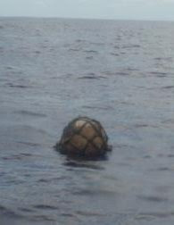 After we processed the fish, Captain, Christiana and I went on an expedition this afternoon. Since conditions were so calm, we decided it was high time to take the dingy out. It was bizarre to watch our home for the past several weeks disappear behind us, but at the same time it was nice to escape from the boat for a bit. We cruised along looking for debris, which is a little harder to spot from the low vantage point of the dingy. After a few minutes we ran into a float-which from a distance looked like a large Japanese glass float. It turned out to be a standard buoy. It was a 300mm float made by Yung Plastic Industries Co. in Taiwan. There was a huge population of barnacles layering the lines attached to the buoy and a decent sized community of juvenile Rainbow Runners taking refuge under the debris. We had some time to jump in the water and film the synthetic habitat while we were waiting for the Alguita to catch up with us. Getting the buoy back onto the vessel required a bit of muscle-there were about 100 pounds or so of barnacles attached.
We are 399 miles out from our desired sampling location and near the 4000 logged mile mark for the trip!
After we processed the fish, Captain, Christiana and I went on an expedition this afternoon. Since conditions were so calm, we decided it was high time to take the dingy out. It was bizarre to watch our home for the past several weeks disappear behind us, but at the same time it was nice to escape from the boat for a bit. We cruised along looking for debris, which is a little harder to spot from the low vantage point of the dingy. After a few minutes we ran into a float-which from a distance looked like a large Japanese glass float. It turned out to be a standard buoy. It was a 300mm float made by Yung Plastic Industries Co. in Taiwan. There was a huge population of barnacles layering the lines attached to the buoy and a decent sized community of juvenile Rainbow Runners taking refuge under the debris. We had some time to jump in the water and film the synthetic habitat while we were waiting for the Alguita to catch up with us. Getting the buoy back onto the vessel required a bit of muscle-there were about 100 pounds or so of barnacles attached.
We are 399 miles out from our desired sampling location and near the 4000 logged mile mark for the trip!Más sobre Day 30
22: Day 31
Day 31
Today was our rest day (although we did set out education trawls and dive for debris still :) Here are a couple pics. One is the cod end of the trawl underwater, the other is a sunset with debris we have collected on deck.

Más sobre Day 31
23: Day 32
 Noon Coordinates: 34°14'27.60"N 174°18'25.20"W
Day 32
Styrofoam is a copyrighted term for a Dow Chemical insulation material. The generic term for the spongy white cups and take out containers we are all familiar with is expanded polystyrene. Photos of waterborne trash accumulations from urban centers invariably show large quantities of expanded polystyrene containers. When polystyrene - think clear CD cases that crack - is expanded, gas is dispersed into the melted polymer creating innumerable channels and bubbles in the material. This makes it a good insulator for hot beverages and food, and gives it a texture that is easy to handle. It also makes it float, since plain polystyrene is heavier than water. Dr. Anthony Andrady, Algalita Marine Research Foundation’s lead polymer scientist, conducted experiments with different types of plastic in the ocean and on land to determine how they lose flexibility, become brittle, and break down into fragments. He found that all plastics except one, expanded polystyrene, broke down faster on land than in the ocean. For most plastics, heat absorption was the key to rapid embrittlement, and the cooler ocean environment acted as a heat sink, slowing the process. But with expanded polystyrene, the increased access of seawater into the pores of the plastic accelerated breakdown more than the increased heating on land. Dr. Andrady found that expanded polystyrene was the only common plastic to break down faster in the marine environment. When I sampled the Eastern Garbage Patch, halfway between San Francisco and Hawaii in 1999, I only found about 10% of the particles in our trawls were expanded polystyrene. These most probably originated in debris from Asia following the debris highway created by the Kurashio current’s easterly extension. Now that we are nearly two-thirds of the way to Japan, we would expect to see more expanded polystyrene and to see it in a less degraded state. This is indeed what we are finding, little bits, medium sized pieces and big blocks. As we approach our goal, the International Dateline, (we are now at 175 West Longitude, only 5 meridians to go), we also are seeing more Asian PET drinking water and soda bottles. Since the caps are made of Polypropylene, not PET and degrade faster, when the caps crack, the bottles fill with water and sink, so we don’t find as many of them in the Eastern Garbage Patch. The Asian origin of the debris is corroborated by markings on much of what we are finding. A Taiwanese fishing float stating “Yung Plastic Industry, Republic of China,” a Japanese Coca Cola bottle, a thin piece of plastic film with Chinese Characters and a Japanese survey stake. All of this debris creates an amazing habitat for a great variety of free-floating larvae looking for a place to settle on and grow. According to David Barnes, of the British Antarctic Survey, plastic debris at the surface of the ocean has at least doubled the mass of the organisms living there. Not only are new species showing up on plastic transported to coastal environments where they have never been before, species that normally live in coastal habitats can be found associated with debris in the deep ocean. This is analogous to the introduction of European weeds and pests into the New World, species that displaced and decimated the natives. It has been speculated that this mixing of biota could result in a reduction of species diversity in the ocean by half. From Captain Charles Moore, sailing toward the dateline aboard ORV Alguita.
Más sobre Day 32
24: Day 34

Day 34
7/13/09 80 miles out from the Dateline and the seas are thick with debris and plankton. We did two 10 minute debris counts today, the morning one yielding 37 pieces and an afternoon one 87 pieces. I realized today that the Alguita has sampled as far as the 170th parallel on previous voyages, and we are now at 179W which means the past several days have involved sampling in previously un-sampled waters-exciting! We typically set out Manta trawls for a period of 1 to 2 hours, but yesterday we could only set the trawls for 15 minutes because the plankton was so dense that it quickly clogged the cod end of the net. While these trawls were delivering high amounts of plankton, the amount of small plastic debris was keeping pace. Within yesterday’s series of 15 minute trawls (we did 4 in total) we noticed a gradient in plastic density. There was a marked difference in the plastic level observed in the first trawl, which was heavy in plastic, and the last of the series, which was pretty light in plastic content. This was covering a distance of roughly 2 nautical miles which just goes to show how dynamic the debris accumulation is throughout the gyre. The education trawl was pulled up wounded from some sort of underwater battle. There was blood pooling in the end of the net and holes ripped in the mesh. Apparently something tasty was trapped inside of the net which something else wanted to eat to bad enough to tear through it. Several chains of baseball stitches later and the net was back in action. This morning Charlie and Drew got in the water to dive a buoy they had captured. As the Captain de-barnacled the debris underwater he became the new refuge for the fleeing crab. Later in the morning we spotted a second buoy with a thriving ecosystem-juvenile Rainbow Runners, crabs, gooseneck barnacles, so we decided to dive it. The bad part about diving in dense plankton zones-the jellies. We were all getting stung left and right by these mesmerizing, yet painful critters. Later in the afternoon we encountered the most bizarre debris of the day; a laundry basket filled with fish. It’s not every day a basket full of fish comes floating your way while you’re in the middle of nowhere. Tiny Rainbow Runners and a few Pilot Fish were stuck inside the basket (at least until the seas got rough enough to throw them out). When we pulled it out of the water we found coral growing on the bottom. A few of the fish were preserved for lab work up and the rest of them were analyzed on board for plastic content, thankfully with no plastic to report. It’s been glassy calm the entire day, shifting from a perfectly sunny morning to a gloomy, rainy afternoon, and ending with a stunningly starry night. As characteristic of the gyre, the winds are light and variable. We’ve been running through a flurry of sail changes trying o maximize the wind.
From the thick of it, Nicole
It’s been glassy calm the entire day, shifting from a perfectly sunny morning to a gloomy, rainy afternoon, and ending with a stunningly starry night. As characteristic of the gyre, the winds are light and variable. We’ve been running through a flurry of sail changes trying o maximize the wind.
From the thick of it, NicoleMás sobre Day 34
25: Day 35

Day 35- We’ve reached the International Dateline!!
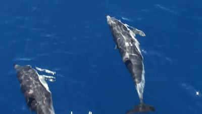
We’ve reached the Dateline!! Finally, 35 days out of Long Beach and 4,441 nautical miles into this mission and we’ve reached our goal, the International Dateline. This latitude line is both 180? E and 180? W and is a brand new line of sampling to add to the databank! Our transition into the eastern hemisphere (and into tomorrow) was quite picturesque. The sun was shining and the ocean was glassy, a pod of Striped Dolphins was performing starboard of the vessel and an albatross or two was flying about. The crew was gathered on deck as Captain watched our position from the helm, counting down our approach to the Dateline. We crossed, and the dolphins decided to up their performance to some aerial moves. Captain joined us on deck and we relished in the moment of achieving our goal for a bit-the conversion tending towards the usual, marine debris. Before we reached the Dateline, we had a strange run in. Around 9am, I was directed from the debris spotters on deck (Captain and Drew) to turn hard starboard so we could fetch an obscure piece of debris in the distance. As Captain was dipping down the net to retrieve it he realized that it was far from marine debris-it was a sea turtle. The presence of this guy highlighted the reason marine debris is such a tremendous issue; the juvenile turtle was feeding in an area where we had been fishing out debris all morning, introducing the possibility of plastic ingestion. We have documented the tangle of debris and zooplankton that surrounds us (see photo below). It is easy to imagine how the plastic fragments could be inadvertently scooped up-and marine debris ingestion in sea turtles has been recorded. So now that we are at the Dateline we are doing what we came here to do-sample, sample, sample. Refreshingly, we pulled up only 3 plastic fragments in the first trawl #29 (at least from what we could see with the naked eye). Manta sample #30, deployed a ½ hour later, produced a ridiculous amount of plankton. Manta sample #33, the last of the day, ran for a half hour and produced an astounding amount of plastic. A stark contrast to Manta #29 deployed 3 hours (roughly 9 nautical miles) prior. As I stated yesterday, the trash accumulation zone is patchy and tremendously dynamic.
We are chugging along at 3 knots with the main and Genoa up, banking on some more wind to come our way as we head north. We will continue sampling along the Dateline for the next 300 miles, up to 40N and then head east after we pick up the westerlies to start our return to Hawai’i.
From the International Dateline,
Nicole
Thank you to ScubaDrew Videoworks and AMRF for the pictures!!!!
So now that we are at the Dateline we are doing what we came here to do-sample, sample, sample. Refreshingly, we pulled up only 3 plastic fragments in the first trawl #29 (at least from what we could see with the naked eye). Manta sample #30, deployed a ½ hour later, produced a ridiculous amount of plankton. Manta sample #33, the last of the day, ran for a half hour and produced an astounding amount of plastic. A stark contrast to Manta #29 deployed 3 hours (roughly 9 nautical miles) prior. As I stated yesterday, the trash accumulation zone is patchy and tremendously dynamic.
We are chugging along at 3 knots with the main and Genoa up, banking on some more wind to come our way as we head north. We will continue sampling along the Dateline for the next 300 miles, up to 40N and then head east after we pick up the westerlies to start our return to Hawai’i.
From the International Dateline,
Nicole
Thank you to ScubaDrew Videoworks and AMRF for the pictures!!!!
Más sobre Day 35
26: Day 36 & 37
 (Nudibranch- awesome photo by Jeff Ernst!!!)
Day 36 & 37
We set out 4 trawls throughout yesterday, still finding plastic in all of them, although in varying densities. We are starting to bring up some different and interesting critters in our trawls. A couple days ago one trawl was filled with Nudibranchs -adorable little guys (see above. Still logging disturbing amounts of debris throughout the day, although under sail it becomes much harder for us to maneuver to retrieve them. We found a replicate debris item yesterday, a white industrial plastic bag (similar to a trash compactor bag) with blue Japanese characters. The first one we logged was on the 14th and was lightly fouled with fish eggs and bryozoans. The bag from yesterday was also fouled with a few barnacles and some bryozoans. This got us to thinking about the source-a container spill or a waste lost from the same vessel perhaps. We had been waiting for perfect night dive conditions, which decided to come around as we were heavy bellied after dinner. But we couldn’t pass up the opportunity. Joel, Drew, Christiana and myself dove on tanks while Jeff free dove with the Sea Dawg-an awesome underwater scooter. Being 40 or so feet underwater, surrounded by bioluminescent creatures, 3,100 miles out from Long Beach, with a couple miles between us and the bottom was surreal. At one point Joel, Christiana, and I huddled together, shut off our lights, and let ourselves get a full dose of the bioluminescence. It was like floating in a bed of stars-very serene and surreal. By waving our hands through the water or kicking our fins, we could light up a swath of critters-enough to clearly see each other in the pitch black water (with some help of Drew’s camera lights). We surfaced to a vibrant night sky with a perfect view of the Milky Way. We are a lucky bunch to have the opportunity to be out here. Although the subject of research is a little grim, there are many positive angles to our situation like diving in a place where no other humans have likely ever set foot (or boat?) We are able to stargaze, free of urban light pollution. Jupiter drifts low across the night sky and we’ve come to notice that it has its own “moonbeam” on the ocean’s surface--pretty cool!. (Eerie photo taken during the night dive by ScubaDrew Videoworks)
Más sobre Day 36 & 37
27: Day 38
 Photo by ScubaDrew videoworks
Day 38
Today was gloomy-starting and ending with rain, although it was kind of nice to get a break from the strong sunshine. Since we are motoring at such a slow speed anyway, anywhere from 2 to a whopping 4 knots, we decided we weren’t loosing much headway by throwing out a manta trawl this afternoon-and yes, there was plastic. Based on reports from Drew about the density of debris particles flowing by the boat we expected to see a lot more plastic in the trawl. It seems that by the time we set up and deployed the Manta trawl we had already passed through the denser band of debris. We pulled in the third industrial grade white plastic bag today, although this one was a smaller piece and did not have the blue Japanese characters. Based on the fouling level and the identical nature of the plastic material we are pretty sure it’s a member of the same bunch. That makes three within four days. Strange event of the day: an attack by a wooden spool stuffed with beer packaging. Drew spotted something “really big” dead ahead of us from his debris gazing spot on the foredeck. I popped up through the hatch with some binoculars and discovered that is was a large wooden spool for wire (about 3.5 ft tall and 3 feet in diameter). We approached it with the boat in idle forward and tried to hook it from the front. The cagey little spool evaded the debris wranglers and ended up bouncing off the port hull. Oops. No harm done thankfully. Captain dove of the aft deck and into the water to attach a line to the spool before it got away. We hoisted it up on deck with the gantry to find two Baltica brand 6-pack beer packages (it’s a Chilean beer) stuffed inside along with a couple stowaway crabs. Upon closer inspection we could tell this was relatively recently deposited debris (based on the lack of fouling and perfectly intact structure) and Captain estimated it was likely jettisoned within a 100mile radius of our position (37 33.84N, 179 13.25E). The spool was wooden with metal odds and ends, so it will all eventually degrade into basic elements and it is relatively inert. An object of that size is however a significant threat to ocean going vessels-as we experienced firsthand today. According to MARPOL Annex V (the International Agreement on Maritime Pollution) placard displayed aboard the vessel (a legal requirement on boats over 25 feet long), plastic is the only material regulated over 25 nautical miles off of land. While plastic is banned from being dumped from vessels throughout the entire ocean as it should be, it seems to be a bit of an oversight to allow large and hazardous debris to be dumped at any location. Even some place as remote as the middle of the gyre is still periodically traversed and things deposited out here will eventually find their way south toward the higher traffic waters near the Hawaiian Islands. MARPOL is up for reauthorization soon, and given that the information on our placard is correct, this might be an issue worth looking into. Wildlife report: Captain and Drew spotted two Fin Whales, a cow and calf, this morning and there were some more spouts spotted later in the day. Backtracking to critters from the night dive: I completely neglected to mention that we spotted a Hyperiid amphipod (Phornima sedentaria). Why is this exciting and what is it? These critters are crazy zooplankton commandos that commandeer the body of salps to make a salp suit. Just before we dove Christiana was telling us the alien from the movie “Alien” (the creepy little thing that bursts from the stomach cavities of the crew) was designed after the Hyperiid amphipod. Look up a picture-you’ll see why. From the gyre, NicoleMás sobre Day 38
28: Day 39- A dolphin encounter unlike any other!

Day 39- A dolphin encounter unlike any other!
July 18, 2009 As a SCUBA instructor for Surf and Sea in Haleiwa Oahu, I do get periodic times to swim with Hawaii’s favorite spinner dolphin, I have even had the opportunity to see bottlenose dolphin. Be it all of these encounters were wonderful and exciting in their own right, nothing prepared me for what I experienced last night. After my usual 2 am wakeup call from Jeff to begin my night watch on another night of motoring through a windless calm at about 4 knots, I noticed an unusual glow coming from the water off of the stern of the boat. I quickly realized that the green column of water trailing the boat for about 100 ft was the bioluminescence resulting from the port engine propeller. Bioluminescence is the glowing green light emitted by a reaction within certain planktonic organisms, when their surrounding water is disturbed. Unless you are on a boat at night in plankton rich water, the next best way to see an example of bioluminescence is to swim, snorkel or dive at night, then turn off your lights and move your hand back and forth through the water. You should see some tiny green swirling lights around your hand. The more plankton in the water, the more lights emitted. Well the waters out here are so rich with plankton, that when Jeff told me I should see the bioluminescence from the bow, I was astounded at what I saw. The catamaran left 2 bright glowing green waves and green swirling lines that followed the bow wake pattern. All the while, bright green bursts could be seen as larger sources of bioluminescence were triggered by the pressure wave in the water. The sound waves of the engine would trigger the reaction in the larger pelagic planktonic organisms deeper and further ahead of the boat, so they would “light up” as we approached. The waveless, windless night combined with a vantage point less than 3 feet from the water’s surface made this a once in a lifetime occasion for me. After 10 minutes of just gazing at this phenomenon, I was suddenly startled as 2 large green streaks shot from beneath the boat, between the hulls and splashed to the surface right in front of me, then split to either side of the boat. Three more streaks shot in from port side and I could see clearly through the water that unmistakable shape...Dolphin! The only way I could describe it was the dance of the sugar plum fairies out of the movie Fantasia, only with dolphin making the trails. I could watch them go deep and the green glow would get dim and then get brighter and brighter as they got close to the surface again...then splash they would break the surface. The shape was created by the glowing green bioluminescence generated as the graceful swimming machine moved through the water. It was like watching an animated movie with special effects…it was surreal!!!! I could clearly see the details of each animal as it swam under my nose just out of arms reach. Tails, fins, body, were all clearly visible with the green outline through the clear calm water. Within seconds I had 10 to 12 dolphin doing what dolphins do….playing in the wake of a boat. The dolphin kept shooting in from the sides, darting up from the deep, two or three at a time, swirling in front of my face, each with its own green silhouette and ocean meteor trail extending at times, up to 20ft behind each powerful tail. For only the second time in my life, my breath was actually taken away. I sat for what must have been 5 minutes in complete amazement by the visual ballet being performed just for me. With tears building up, I thought this is not fair that my wife Jamie couldn’t be here to experience this with me, this is just one of those times you want to share with loved ones. I then thought, maybe I should wake the crew. Well Christiana was first to show up and the dolphin continued the show. At one point we saw a big green ball rise from deep beneath the boat only to explode into 5 individual silhouette trails dancing apart, then coming back together as the graceful sea mammals continued their dance while trails from flying fish scattered about. Nicole and Charlie finally got up in time to see the show before the dolphin went on their way, but Joel and Jeff didn’t leave their bunks…oh well, their loss. We think they were the same pod of common dolphin that came by after the sun came up. One of the things that crossed my mind while watching this light show that was taking place, was the question of what it must look like from underwater and the realization that, dolphin have good eyes so they get to see this all the time from under water. Just another reason why I believe when it comes to rank on the life ladder, we are several rungs below the dolphin, they are just designed too perfect…they don’t need technology to create their own light show.
This will rank as one of the greatest experiences of my lifetime! It’s just sad to think they have to swim through all that plastic that I see during the day.
Writing and photography by crew member Drew Wheeler (Thanks Drew!!!! )You can learn more about his underwater videography at http://www.scubadrewvideo.com/ and follow his account of the voyage on his blog at http://trashvoyage.com/
One of the things that crossed my mind while watching this light show that was taking place, was the question of what it must look like from underwater and the realization that, dolphin have good eyes so they get to see this all the time from under water. Just another reason why I believe when it comes to rank on the life ladder, we are several rungs below the dolphin, they are just designed too perfect…they don’t need technology to create their own light show.
This will rank as one of the greatest experiences of my lifetime! It’s just sad to think they have to swim through all that plastic that I see during the day.
Writing and photography by crew member Drew Wheeler (Thanks Drew!!!! )You can learn more about his underwater videography at http://www.scubadrewvideo.com/ and follow his account of the voyage on his blog at http://trashvoyage.com/Más sobre Day 39- A dolphin encounter unlike any other!
29: Day 42- Wind and ocean currents
Noon position: 40°50'29.98"N 173°19'55.80"W
Day 42- Wind and ocean currents
We are 5,200 miles into our journey and back in the western hemisphere, starting to make our way south with a heading of 115. Our speed over ground (SOG) is 7.6 knots and we’re getting winds out of the west at 20-25 knots. These are the winds we want to see-the Captain and crew are anxious to make it to Honolulu. We all have prior commitments that have been put in jeopardy by the weather conditions. The winds started really picking up yesterday evening, jumping from 6-8 knots in the AM to 20-25 in the PM as we headed north. We took advantage of the situation by sailing downwind with the lovely, yet hard to please, spinnaker. For a while the winds were hovering around 30 knots, throwing large rolling swells at us which compromised the accuracy of the autopilot system. We were flirting with a disastrous collapse of the spinnaker and it became necessary to steer by hand. Drew was first in line for the job and Captain came in to relieve him after an hour. Christiana and I were watching his technique (how much to turn the rudder to compensate for the swells, when to overcorrect, when to make small adjustments, etc.) when we looked up to the sudden, violent collapse of the sail. The crew donned life vests and rushed to the foredeck to fish the sail out of the water. The damage to the sail was pretty severe. On top of a second broken spinnaker halyard there is now a huge tear running up from the foot of the sail. We lost the most efficient sail for the current weather conditions-which lowered the morale a bit. Of course, we still have other sail options and have been making do with various combinations of the Genoa jib, Stays’l, and mainsail. Part of our issue is that the nature of the area in which we have been sampling is a high pressure zone. High pressure zones are characterized by light winds. We needed to spend the fuel to motor through these calms to in order to even run the Manta trawls. The past several days have been working towards an escape from these conditions, using sail power and not trying not to use the ever dwindling fuel supply. Our plan of escape: sailing north. This may seem a bit illogical since our destination is way south of us, but there just so happens to be a rhyme to our reason. Here’s Joel on the subject: “Since we are a sailing vessel and we must sail to get home, we need to find where the favorable winds are. The wind and currents in the North Pacific Ocean are dominated by the large gyre at its center. The wind in the California Current flows from north to south and is the eastern edge of the gyre, the Trade Winds blowing toward the west and southwest make the southern boundary, the Kurshio current flows south to north off the east coast of Asia makes the western edge of the gyre while the westerlies blow back toward the West Coast of North America and make the northern boundary of the gyre. (note: keep in mind that winds are named for the direction they originate from. Thus westerlies come from the west, easterlies from the east etc.). All together they make a giant clockwise circular current and wind system with high atmospheric pressure and calmer variable winds at the center known as the North Pacific Subtropical Gyre. It is one of five major gyres in the world’s oceans. There are three in the northern hemisphere (The North Pacific, North Atlantic, and the Indian Ocean) which spin clockwise. In the southern hemisphere the South Atlantic, South Pacific and Indian oceans spin counter clockwise. The most direct course home would have been to motor into the trade winds in the southern part of the gyre, but since we need to sail to get home we must go north and find the westerlies which blow to the east. Once we go far enough east we will make a right hand turn and will have to pass again through the center of the high pressure system which is blocking our path to Hawai’i. The light and variable winds from the gyre will eventually hook us up with the trade winds and we can use them to hastily return us to Oahu.” The Corilolis Effect is the driving force behind the current and wind systems Joel described above. In the most basic sense, the Coriolis Effect is a result of the west to east rotation of the earth. This means that air flow is affected by this motion. For example, an object on a trajectory directly from the North Pole directly south would be deflected to east. In the southern hemisphere, an object traveling from the South Pole northward would be deflected to the west. Air pushes water to create surface currents, thus the deflection I just mentioned from high pressure systems, combined with boundaries created by earth’s landmasses encourage the dominant currents, like those described by Joel to maintain their clockwise (northern hemisphere) and counterclockwise (southern hemisphere) rotations. Furthermore there are several convection cells of air resulting from the combination of the rotation of the earth and the differential heating of the earth. So the sun hits different parts of the earth at different angles. The more direct the angle of sun exposure, the more that surface will be heated. This is why it is so hot along the equator, where the sun hits directly for much of the year, and so cold towards the poles where there is little direct sun exposure. This differential heating results in the rising and sinking of air. Cool air sinks, warm air rises. So as air is sinking and rising (on the macroscale) as well as being subject to the Corilolis force dominate wind patterns, such as the Tradewinds (named for the reliability of the winds for trade) are established. On another note, reports from the wildlife front: Christiana dissected two fish today-a large flying fish (we think it’s Hirundichthys albimaculatus based on the key we have on board) and the first tuna of the trip (it was an Albacore). No plastic to report in either of them. Two nights ago we were visited by a half dozen friendly Leach’s Petrels. Well not so much friendly as they were attracted to our running lights. It’s a dangerous situation for the birds to be hovering so close to the moving vessel, there are far too many lines and hard surfaces for them to maneuver around. But it’s also not an option for us to shut off our running lights-that would put us in a lot of danger. The story ending happily though-none of the birds were hurt and we were entertained by their spastic flapping and their almost monkey-like chirps. We are still finding debris, although it is significantly sparser. The areas we are transiting through at the moment are thought to be contributing waters and not accumulation zones of debris. Visual observations from the crew confirm this theory-although the waters have been quite choppy which makes anything but the large and prominent debris very difficult to spot. Bottom line, we still encounter debris after a few minute stint on deck and we have yet to pull in a trawl (we’ve done 42 so far) without plastic fragments. From the Pacific, NicoleMás sobre Day 42- Wind and ocean currents
30: Day 43- Balloon
 Noon position: 39°18'31.80"N 170°23'19.20"W
Day 43- Balloon
5400 miles into the trip, 8knots over the ground, 20 knots of wind. No trawling can be done in this sea state (we learned our lesson on the first leg with the broken Manta, plus our priority is making good time to Honolulu) and the weather hasn’t exactly created the most welcoming deck conditions (it’s rainy, and windy, and cold). Drew has still being doing his morning debris watch which involves tracking the minutes to his first debris sighting of the morning. He clocked a record 10 minutes the other day. That was the longest period of time he’s had to wait to spot debris after walking out on deck. Needless to say, we have a lot of time to reflect on what we are finding out here. The other day we pulled up a balloon out of the water. It was the knotted end of a bold turquoise balloon attached to some sort of plastic clip. There was no fouling and it appears to be fairly recently deposited. It would have taken years for the balloon to make its way out here via ocean currents. Perhaps it caught some wind off of Japan while it was still inflated or maybe it was released off of a cruise ship passing through the Pacific. This is the second balloon fragment of the trip. Towards the beginning of the voyage we pulled in a balloon ribbon on one of our fishing lines. As Captain Moore has pointed out several times-balloons are key examples of a frivolous use of plastic. They are mass produced and are now a celebratory staple of sorts at birthday parties, graduation ceremonies, school dances-the list goes on. I remember arches of hundreds of balloons created for high school pep rallys and football games. After the events, sometimes the balloons would get popped and other times they’d been ceremoniously released into the sky. I was recently a part of a team from CSU, Long Beach’s Environmental Science and Policy Department that was focused on trash accumulation and categorization at the Colorado Lagoon. The Colorado Lagoon is remnant of the historical Los Cerritos Wetlands Complex which is one of the few (although highly degraded) remaining wetlands in Southern California. Balloons, or fragments thereof, surfaced several times in our transects. They are polluting the most remote parts of the world (the middle of the Pacific Ocean) as well as our terrestrial ecosystems. Balloons are used once, typically on the scale of hours at a time. Why use an everlasting material for this sort of practice? Furthermore why release this material ceremoniously into the environment?Más sobre Day 43- Balloon
31: Preparing for the 2009 Gyre Expedition
Pacific Gyre Expedition 2009 Voyage #1
The quantity of plastic pollution in the ocean is increasing rapidly, paralleling the rapid rise in global plastic production. Each time the ORV Alguita crew collects samples from the North Pacific Subtropical Gyre, we find that the abundance of plastic has increased since our previous visit. In previous research voyages we have found a very high abundance of plastic in the area of the gyre that has come to be known as "The Eastern Pacific Garbage Patch", but we suspect that the contamination is much more widespread. This summer we will have the opportunity to test this hypothesis during the first voyage of our four month research expedition. During this voyage the ORV Alguita research crew will be at sea for over six weeks as they sail west from California past the Northern Hawaiian Islands as far as the International Date Line (180 degrees longitude) to sample areas of the Pacific Ocean previously un-sampled for plastic marine debris. We will be collecting samples of plastic debris, plankton and fish to analyze back in our laboratory to better understand not only the quantity of plastic debris pollution in remote areas of the ocean, but also the impacts the plastic is having as it is consumed by marine animals. Below is a map that shows the area where ORV Alguita has sampled for plastic pollution over the past 10 years. The first voyage of the summer expedition hopes to extend the study area all the way to the International Date Line at 180 degrees longitude.
Meet the Crew!
Get to know the six dedicated crew members that will be corresponding with you during the upcoming voyage. Find out about how they got involved in oceanographic research, and why they are willing to leave land for six weeks to study plastic marine debris in remote areas of the Pacific Ocean. Click here to read more http://orvalguita.googlepages.com/meetthecrew!
If you would like to post a comment or question to the crew click here!Más sobre Preparing for the 2009 Gyre Expedition
32: Bon Voyage ORV Alguita!
ORV Alguita has just departed on the first voyage of the 2009 Pacific Gyre Expedition!
Más sobre Bon Voyage ORV Alguita!
33: Day 2
Day 2
Noon Position: 31°49'26.40"N, 119°20'42.00"W Hi Students, Thanks for all of the fantastic questions and comments you have sent our way! Today is our first full day at sea and the crew is still getting used to the swing of things. Only one case of sea-sickness so far, and we’ve spotted some pretty cool wildlife. This morning we spotted four Fin Whales roughly 100 yards of the starboard stern of the vessel, and one more whale who was a little too far from the boat for us to identify. Many of you are wondering the same question: what are we going to eat? The Alguiita is full any kind of food you can imagine. Last night the crew had stuffed mushroom and a fresh green salad. This morning we woke up to a homegrown boysenberry cobbler cooking in the oven. As many of you saw at the send-off, the deck is full of delicious fresh produce; we have everything from kale to chocolate persimmons to snack on. -Nicole-Day 2 (click here to read more)
Más sobre Day 2
34: Day 3 Dolphins and Debris
Day 3- Dolphins and debris
Greetings from the ORV Alguita! In the past 24hrs, we have had our first series of debris encounters. While taking in our fishing lines for the night, we dragged in our first piece of debris; a deflated green balloon with the string still attached. It was a little disheartening to discover that we were fishing for trash instead of fish. Last night at around 10pm, we passed the Exclusive Economic Zone (EEZ). For those of you who are wondering what that means, we are now officially out of the US waters, in what is essentially the no-man’s land of the Pacific. Because this area is out of US jurisdiction, it is not a top priority in terms of government funded research.We were greeted in the morning with another debris sighting. We found a plastic water bottle (see photo above) which likely originated from Russia (the cap had Russian text). It had been afloat in the ocean just long enough for fouling organisms (i.e. tiny baby gooseneck barnacles) to latch on.
Our next trash sighting, roughly 300miles out to sea, was a tangle of fouled line and buoys. In addition to gooseneck barnacles making their home inside the floating mess, we found several pelagic crabs and a couple of different invertebrates. After weighing the mass of rubbish (9 kilos) we preserved a sample of the debris with the critters that we found living on it for Miriam Goldstein, a doctoral candidate at SCRIPPS, who is studying the fouling organisms that live on pelagic trash. The last two pieces of trash found today were a Monarch brand garlic-salt container and a plastic napkin or towel floating on the surface. These finds are indicators that we are making our way into the heart of trash accumulation.
As far as wildlife sightings go, we had a pod of Common Dolphins passing us on portside (see photo above). We also spotted several Velella velella, also known as the By-the-wind sailors, which is an awesome little sea creature that has a small oval sail so it can use the winds to travel the seas.
Best Wishes from the Captain and crew
Cheers,
Nicole
Más sobre Day 3 Dolphins and Debris
35: Day 4- First open ocean swim!
Noon Position: 29°12'28.80"N 124°56'13.20"W
Day 4- first open ocean swim!
Can anyone identify the animal in the photo above? (Hint: Check out the links on day 3!) Más sobre Day 4- First open ocean swim!
36: Day 5
Day 5
Hey guys, the ORV Alguita team needs your help!Most of the debris we have captured from the ocean has contained barnacles and crabs. All we know about the crabs is that they are pelagic (which means they spend their life floating throughout the open ocean). Can anyone help us find the name of the pelagic crab in the picture Above? Today is day 5 at sea, all is well and the crew is in great spirits. Now that the all of the crew is up to speed with watch duties, we have switched to 2 hour, single watches. This is a lot easier on our sleep schedules. There is however news to report regarding our travel plans. Due to a large and persistent high pressure system, we have to rethink our original route, which would have deposited us along the International Dateline (180W) at latitude of about 35N. Because of the high pressure system we are dealing with light winds, which is not optimal for sailing. The weather has forced us to spend most of our time underway motor sailing. We have already used roughly 200 gallons of the 700 gallons we started with? If we keep up at this rate we will exhaust our fuel supply. At this point we are forced to bend to the will of nature and follow the winds. As is required when dealing with the seas, the Captain has a backup plan. Our new route and sampling strategy will take us to a more southerly location than planned, but will still present us with ample research opportunities. The new plan is to continue our heading south in order to catch the easterly trade winds. This route will bring us to Hawai’i and allow us to survey a debris convergence zone located off the southern tip of the Big Island. This convergence zone is thought to be responsible for the accumulation of debris on beaches such as Kamilo. After sampling this convergence zone, we can refuel and head up the island chain toward the International Dateline at a lower latitude than planned. How far we will actually get is to be determined by the amount of time it takes us to get to Hawai’i in the light winds we have been experiencing since we left.Speaking of debris sampling, today’s debris catch was a 300mm buoy fouled with barnacles and pelagic crabs. (See photo of Captain Moore on left.)
Keeping in tune with the rest of the weekend, the weather was phenomenal. Much of the day was spent out on deck stretching our limbs and taken in the scenery (which is mainly….water). Capt. Moore gave a presentation to an assembly of 14-18 year old students at Hawai’i Preperatory Academy. He was able to lead them through a power point presentation via satellite phone.
Our wildlife sighting for the day included a Red tailed Tropic Bird and some Petrels.
If you would like to see more about what our home on the research vessel is like here is a link to a video and slide-show tour of ORV Alguita http://orvalguita.googlepages.com/touroforvalguita
Más sobre Day 5
37: Day 6- First manta trawl!
Noon position: 24°52'40.80"N 128° 9'57.60"W
Day 6- First manta trawl!
It’s Day six and we are officially 2/5 of the way to Hawai’i. Day six has been a day of firsts-- the first plastic trawl of the trip, and our first fish catch (a Mahi Mahi!). Let’s start with the trawls. While the winds have been against us in terms of maintaining our original course, they have put us in an area of the Pacific which had never been sampled……until today! See the map below or Click here, to view more maps of our previous sampling areas. We deployed the first Manta trawl, a device that captures surface debris in a fine mesh net, at 9am. This process was akin to riding a bike for the Captain and veteran crew Drew, Joel and Jeff, and a learning experience for the newbies (Christiana and myself).
After an hour of towing the trawl we pulled it in to find a strikingly low amount of plastic. Among the plastic identified was some line, a few hard plastic fragments, and a piece of a clear plastic label on which we could decipher the letter “d”. Among the life identified in the sample was a button valella, some copepods, a juvenile Pacific saury, and tiny gastropods with gorgeous purple shells. (See image of sample at the top of this message.)
The evening brought on trawl number two. This trawl gave us the opportunity to experiment with a tethered underwater camera, which Joel was able to rig to record the underwater flow into the Manta trawl. This was a significant in that it confirmed the integrity of our surface sampling methods. We ran the evening trawl for an hour as well, finding results similar to the morning trawl--very little plastic.
Obviously the low quantity of plastic present in samples is good news, but it does highlight a key point. Throughout fifteen years of sampling, we have yet to bring in a trawl completely void of plastic. While standing on the foredeck today, the Captain was able to identify plastic fragments flowing past the vessel. We also spotted some larger debris, a 5 gallon bucket which managed to evade our collection efforts. The point is, even in this new sample area in which our trawls our producing comparatively low amounts of plastic-there is still enough debris present for us to visually register and in our trawls. The relatively low amount of plastic also points to the possible delineation of the boundaries of an accumulation zone, although it is far too early in the data collection process to make any definitive conclusions. Joel noted that during the JUNKraft expedition last summer he and Marcus Eriksen noted a similar trend in abrupt transitions in plastic accumulation as they skirted the south edge of the accumulation area.
And finally, after five days of rigging fishing poles and hand lines, we had our first catch. Christiana kept the liver and other organs and tissue for future analysis.
Best wishes from the Capt. and Crew
Más sobre Day 6- First manta trawl!
38: Day 7
Day 7
Hello from the Capt. and crew! We are still headed for Hawai’I, but have added a slight detour to the northwest of our route. Dave Foley, an oceanographer with NOAA, has predicted an accumulation zone not too far out of our way and we are headed there to investigate. You may be wondering, “where is he getting the idea that marine debris might be accumulating in this area?” Well, Dave has put together the Debris Estimation Likelihood Index (DELI) based off of chlorophyll levels. Essentially high levels of chlorophyll correlate to high levels of plankton. Plankton rides the ocean currents, as does marine debris. So it is hypothesized that where the currents have caused an accumulation of plankton, there might also be an accumulation of debris. We deployed the third Manta trawl of the trip this afternoon. The trawl produced lots of juvenile sawrys, some more of the purple gastropods which Capt. Moore has identified as Janthina janthina, and to our disgust, but not to our surprise, several plastic fragments and some plastic line. After trawling we practiced how to heave-to, which is a way to set the sails that effectively stops the boat from moving forward. This is an important tool to have under our belt in the case of an emergency. Since we were already stopped from the heave-to drill, the Captain, Christiana, Drew and Jeff decided to take a dip in the ocean. Capt. Moore searched for trash while Drew captured underwater footage of the debris gathering. They pulled up a piece of a plastic shopping bag, a newspaper packing band, and some plastic fragments. This is what happens when throwaway consumerism meets the open ocean. The winds are starting to pick up and the seas are beginning to get a little feistier. Some of us are reapplying our scopolamine patches, and others have sea legs (and stomachs) just as sturdy as ever. The day ended with a valuable lesson (at least for me): don’t leave the hatches open. As you can imagine, hatches and active seas don’t mix very well. I experienced this first hand today as a large wave swept over the deck and down the hatch located DIRECTLY above my head. Needless to say, I was jostled from my pre-watch nap with seawater to the face and left with a pile of wet sheets. We are cruising along at a speed of 9.0knotts and climbing; the fastest we’ve seen yet…and we are achieving it without the help of our engines!Más sobre Day 7
39: Day 8 and 9
Day 8 and 9
Flying kites, flying squid, flying fish, and a pirate ship (well not really)… We’ve been sailing downwind with a big sail called the "spinnaker" (or in sailing terms "flying the kite") for the past two days. Downwind sailing is wonderfully calm (even in 20 knot winds) and the spinnaker is really is like a giant kite.Más sobre Day 8 and 9
40: Day 10 and 11
Day 10 and 11
Midday presented several of us with the opportunity sit up on the foredeck and catch some rays. In between flipping pages we’d take in the sights of the gyre, sometimes Albatross and flying fish, other times flotsam such as lotion bottles (see picture to left.)“We did have a bit of craziness on deck today, when we accidentally snagged an Albatross with one of our trolling fishing lures. I was filming the graceful bird swooping over the waves when it landed right in the path of one of our fishing rigs. Well, before we knew it the poor bird was snagged and being dragged across the ocean, unable to regain control. With some quick thinking, we reeled the bird up to the boat where Joel took control of this very awkward animal. He has spent time in the Northwest Hawaiian Islands so he has had experience in handling Albatross. The good news is the line was the only thing snagging the wing--not the hook. So with a freed wing and some feathers in need of a little primping, we let her go back onto the big blue and watched as she stretched her wings out and prepared for flight a flight back home…only 1000 miles away. Amazing birds they are…fly thousands of miles to feed in the open ocean.”
Our encounter with Billy was a harsh reminder for us all; we leave our footprint where ever we go. It is important for us to be acutely aware of our actions to keep from inadvertently harming earth’s flora and fauna.
Today, with roughly 1900 miles under our belt, we reached the outskirts of the accumulation zone we’ve been aiming for. The early morning was spent fine tuning the Bongo nets and Manta trawl for 24 straight hours of sampling over a 80 nautical mile transect. Why the continuous sampling? Well Dr. Nikolai Maximenko, with the School of Ocean and Earth Science Technology (SOEST) in Hawai’i is interested in meso-scale variations across this predicted accumulation zone. Basically, he wants to see if a debris gradient can be established from the boundary to the actual accumulation zone. So, as I mentioned before we are sampling, within, and outside the boundaries. We are running trawls for 2 hours, collecting the samples, and then redeploying them.
By 10am all hands were on deck and the sampling marathon began. It’s going to be a long, yet fruitfull night. With a sea state ranging from 5-6 on the Beaufort scale, conditions have not been ideal for sampling, but we are working through it. The swells are the largest we’ve seen all trip. They are awe inducing, especially when they are positioned to crash right over the deck.
Coming from a first timer to the gyre, the samples we collect are truly astounding. In one regard it is amazing to have the opportunity to get up close and personal with planktonic organisms we catch while trawling. Today we caught several Portuguese Man-of -Wars, which are mesmerizing little critters. On the flip side, it is disturbing to watch chunks of debris spill out of the nets. It is bizarre and unsettling to find the detritus of our haphazard consumer lifestyle in one of the most remote parts of the world.
From the cutting edge of marine debris research,
Nicole
Más sobre Day 10 and 11
41: Day 13
Day 13- Plastic in a mahi mahi
June 22, 2009 Chrisitana and Jeff each reeled in a mahi mahi today, one right after the other. The fish served a double purpose, science and sustenance. Before we filleted the fish, Christiana took muscle and liver samples of each of the fish and looked in their stomachs. Fish number 3, the mahi mahi that Jeff reeled in, contained what the Captain confirmed via microscope as a piece of plastic film. This now makes 8 species of fish in which we have identified with plastic in their gut. The last set of trawls came in at 5pm. It was a productive, though hectic, sampling marathon. Although the samples have yet to be thoroughly analyzed, we were able to spot differing densities of plastic within and outside of the boundaries of the plankton (and possibly debris) accumulation zone. At the end of a long stint of sampling and a significant find of plastic in a common food fish, the Captain prepared one of his specialties chili rellenos accompanied by rice, beans, fresh guacamole, and fresh salsa. It was a perfect end to a productive day. We are now en route to Hawai’I with aboiut 400 miles to go. Stay tuned for more updates and be sure to check out the Scientific American website in the “60 second science blog”, where Drew ‘s weekly account of our voyage is posted. ANSWERS TO STUDENT QUESTIONS Regarding the question to Joel about the JUNKraft from State Street Elementary: "I built and sailed the JUNK Raft with Marcus Eriksen who had built a bottle boat and floated down the Mississppi River a few years ago. We thought that building an ocean going bottle raft and sailing it from Long Beach to Hawaii would be a great way to bring attention to the problem of plastic pollution in our oceans . Your right unfortunately birds are sometimes caught in fishing gear. Part of the federal government called the National Marine Fisheries Service helps fishermen design fishing gear that minimizes the number of birds that get caught. Sometimes I do get seasick. I’m taking medicine while on the ORV Alguita that keeps me from getting too sick. On the JUNK raft I didn’t have to take any medicine because the JUNK was so slow and steady." Joel Paschal- ORV Alguita CrewMás sobre Day 13
42: Day 14
Day 14- More Mahi
July 23, 2009 Our resident Ichthyologist, Christiana Boerger’s, account of the day: Today we hooked 3 Mahi Mahi! This puts our total fish catch up to 7. Mahi Mahi (Coryphaena hippurus) are also referred to as Dorado or Dolphinfish. They put up a great fight when you reel them in, actually jumping out of the water. When we catch the fish, I dissect them to look for plastic in their stomach and save samples of tissue to analyze for POPs (persistent organic pollutants) later in the lab. The dissections were particularly interesting today! I go through some simple steps to get the samples I need. First, I record the time and location of where the fish were caught. Then I take some simple measurements, standard length (the length from the tip of the closed mouth to the end of the caudal peduncle) and weight. Next comes the fun part for me, opening them up! I carefully take scissors and cut from their natural opening (anus) to the bone located in between the pelvic fins. I carefully cut out the liver and place it on a piece of tin foil which will be frozen until it can be looked at back at a lab for toxin analysis. I check out the gonads to reconfirm the sex of the fish. These are all females but none of them have had developed eggs yet. Next I remove the stomach. I make another cut to open up the stomach completely to take a look around. The last thing I do is take a muscle tissue sample of each of the fish, which is frozen along with the liver. No plastic in the stomachs today, however, in the first Mahi, there were 3 whole fish in its stomach. I identified them to be some sort of puffer fish. You could still feel the spikes on the skin. The second Mahi had a less digested pufferfish. I was actually able to pull out the stomach of this pufferfish and found its last meal to be crustaceans (probably crabs). I found some more bones in Mahi #2’s stomach, which I identified to be from a flying fish, due to its super long pectoral fins. The third Mahi had an empty stomach, except for a couple different types of parasites which were still moving around. We have caught small flying fish in some of our trawling nets and I am very interested to see if I will find any plastic in their stomach’s, seeing as I now know they are a part of the Mahi’s diet. So exciting from a research perspective!! Needless to say, we’ve got enough Mahi to eat for days, and Joel has made some Mahi jerky, Jeff made some Mahi poke, and the Captain is preparing a dinner tonight of what else, but Mahi sushi rolls and sashimi!! The ORV Alguita Fish Nerd, ChristianaMás sobre Day 14
43: Day 15
Day 15
Day 15 began with sunshine, a sail change, and a blue water expedition. After breakfast, the crew rallied to take down the sails in preparation for the blue water expedition. Here is the Captain’s account of the morning: “This was the first dive in the outer waters of the Gyre for "Scuba Drew" Wheeler, a veteran of our 2002 Gyre voyage. As we were tanking up for our dive, I saw a dish soap bottle astern that had been afloat for some time. I jumped in with mask and snorkel and saw that birds had pecked a few quarter size holes in this bottle, the shape of your smaller Joy or Dawn bottle, and inside was a condominium for a colony of sea life, including crabs and fish. After filming this, a larger school of fish around a black plastic bag's tangled remains, and retrieving a handful of miscellaneous ropes and line balls and other plastic fragments floating by, Drew remarked that this collection of trash in a few minutes was as bad as it was in the center of the accumulation zone 7 years earlier on his 2002 trip, an area over 600 miles to the north of our current position. We are regularly reminded of the speed at which the plastic pollution of our ocean is increasing.”
The concentration of debris we found subsurface really was astounding. We collected 10 separate pieces of debris in less than an hour…and as Capt. Moore stated above, we aren’t even in the concentration zone.
“Although the official accumulation zone of the North Pacific shown on NOAA maps is rather long and narrow, the debris there has to "accumulate" from somewhere, and that somewhere is everywhere else. More and more stuff is out here, everywhere we look, every time we are underwater. What will eventually happen to all this seaborne plastic waste? We know it is constantly becoming more brittle and breaking into smaller pieces. Will it, in this way, eventually all be eaten by some sea creature? ”
A big aloha from the Capt. and crew at the cutting edge of marine debris research,
Nicole
Más sobre Day 15
44: Day 16
Más sobre Day 16
45: Day 21-Back at Sea!
Day 21- Back at sea!
It’s our first full day back at sea since our stop in Honolulu. It was refreshing to see what a great job Oahu is doing to phase out single use plastic items! The fuel dock at Ala Wai Harbor provides only “potato-ware” and paper bags in their convenience store. The crew made our way up to the North Shore and found several local places using compostable versions of ”disposable” utensils and cups and even sustainable to-go packaging. Many of the local business are part of a coalition of called Plastic Free Hale’wia and have vowed to keep one time use plastics out of their business practices. While compostable bags and utensils are a HUGE step in the right directions, in order get the full potential out of these alternatives they need to be composted. Eventually a commercial composting facility will need to be introduced on the island to handle a large scale switch to compostables. And on the flipside, many businesses feel it is pointless to carry compostables if there is no facility to take care of the breakdown process. It’s a bit of a catch-22, but thankfully the switch is moving along. What other alternatives can you think of to using disposable items like single-use cups, straws, forks, and water bottles?On another note, congratulations to Joel and SCUBADrew who will have the opportunity to return to present the results from this voyage to Kahuku High School on Oahu. In addition to sharing our research they will teach the students to monitor the beaches around Kahuku point for marine debris. Kahuku beaches are the most heavily plagued by marine debris wash-up on the island. We will look forward to hearing more about how this monitoring goes!
Aloha from the Captain and crew!Más sobre Day 21-Back at Sea!
46: Day 22- Biggest debris day so far!
Day 22-The Biggest Debris Day so Far
Surveying the ocean from the foredeck, Captain Moore called to me during my morning watch, “we are passing through a plankton bloom”, and sure enough I could see what was a planktonic version of the yellow brick road: a dense winding, river-like bloom of yellow-orange plankton drifting across the ocean surface(see photo above.) From his experience Captain knew that these dense windrows (long streaks on the ocean surface a few meters wide) are often tantamount to a dense oceanic stream of trash. Sure enough, he took a net to the bow and scooped up several pieces of debris within the first 20min or so. And so began our day of chasing debris through windrows.After two hours of tracking and scooping debris from the deck, we decided it was high time to get into the water and observe the trash in situ. As we coasted into a particularly dense zone of the windrow and shut off the engines, we encountered our first ghost net (an abandoned fishing net which coalesces into a destructive mass that smothers marine life from coral reefs to the Hawaiian Monk seal).
We were able to get the net on deck after filming the marine life that decided to find shelter under this traveling debris mass. We found the all too typical ingredients of the plastic soup-bottles from cleaning and personal care products, buoys, fragments of plastic bags and hard plastics, and even a menacing hook from a long-line fishing operation which was tangled in the ghost net. It’s sobering to realize that the items are found with such regularity within the NPSG that I am able to describe them as “typical ingredients.”
Fouling organisms were abundant within the debris -crabs, barnacles, bryozans, and bristleworms. Of particular note was a crab with barnacles growing from its head (we are still not sure of the crab species we are finding, but we have seen them swimming separate from the debris). We also netted a juvenile and adult Frogfish (Sargasso Frogfish we believe), which was an unusual find for us.
The crew is all in good spirits and working in full gear to document the debris state of the Pacific. We are motoring along (winds are barely puffing at a sad 5 knotts or less).Más sobre Day 22- Biggest debris day so far!
47: Day 23 Attack of the Ghost Net!
Day 23 Attack of the Ghost Net!
Before dawn this morning the vessel was attacked…by a ghost net. The force of the propeller rotating at 2400 revolutions per minute wound the net so tight around the drive shaft that it thrust the motor forward on its mounts one full inch and started a horrible grinding of metal on metal with the alternator hitting the belt guard. Lucky for us, Drew and the Captain got lights and knives and were able (after an hour or so of sawing) to cut off the intruding net and its now residing on deck with the rest of our collected debris. Many vessels are not so lucky though. It has been estimated that 6.6 billion Yen/yr (almost 70 million US dollars) is spent on damages to Japanese fishing vessels under 1000 gross tons because of marine debris related incidents (Takehama,1990). In 2005 the National Oceanic and Atmospheric Administration (NOAA) found that marine debris caused 269 boating accidents and $3 million in property damage. We are now motoring along over the Pacific Seamounts, specifically Sibelius, Haydn, Ravel Seamounts which are named after famous musicians. We are relaxing, watching a gorgeous Pacific sunset and waiting for cornbread to come out of the oven. All the best from the Captain and crew. --NicoleMás sobre Day 23 Attack of the Ghost Net!
48: Day 24
Day 24
We are heading north in search of winds, without much luck still. The nice thing about heading north-each day the sun seems to set a little later. Who can complain about more daylight? This morning we deployed the 11th Manta trawl of the trip. This sample contained far more plastic than any of the past 10. We are deploying another trawl this evening in order to capture the mesopelagic fish which feed on the surface at night. We also are discussing doing early morning trawls (around 4 am or so) in order to catch these fish after they had fed. This may yield a more accurate plastic ingestion count, since we might be able catch the fish before they pass any plastic they ingested. In addition it would be interesting to see if there is a difference in the quantity of plastic pulled up after marine organisms have been feeding throughout the night. The afternoon was spent watching for debris off the foredeck. Along with several fragments of plastic, we found a large polystyrene buoy, under which a school of Mahi Mahi had taken residence. After disturbing the shelter of the fish, they scattered frantically-right into one of the lines we had trailing behind the boat. Christiana worked up the fish and found a possible plastic particle in its stomach which has been preserved for on shore lab analysis. She also noticed that this female had completely hydrated gonads. This means she was ready to spawn, but the odd thing is that Mahi typically spawn in the springtime. She was the 11th Mahi we have caught so far (and we have still only pulled in one male!) She was also heaviest and the longest.Más sobre Day 24
49: Day 25 and 26
Day 25 and 26
We are back in Vallela territory again. As we headed further south on part 1 of the trip, we stopped seeing the little guys blanketing the ocean surface. We saw a pod of common dolphins yesterday, playfully swimming off the port bow of the the Alguita. The sun was just beginning to set, which created quite the picturesque moment. The moon is pretty close to full now and we've taken to watching the path of luminescence it creates on the calm ocean surface. We are roughly 650miles from our destination of 35n and 180W, and cruising along at a speed of 7knots. The southerly winds finally found us! .Now let's talk trash. The weekend was jam-packed with chasing down and wrangling debris and dissecting fish, constantly reminding us of the burden mankind has put on this vast and precious ecosystem. Here is Drew's description of the plastic debris we have been encountering:
"There was one 5 minute section where we found 4 plastic fishing floats along with numerous plastic bottles, rope and fragments. All in all today we scooped up 12 plastic floats and about 2 dozen other odd pieces of plastic debris. I can’t even begin to count how many pieces we did see but were too small for the pole nets and or too far out of reach off the boat. No matter how hard we tried, we just couldn’t pick up all the trash we see…it is impossible!
Our manta trawls today were the highest plastic concentration we have seen yet on this trip…and in my case the heaviest I have ever seen and we are still way outside of the center of the trash vortex. The pictures are from 2 ea. 2 hour trawls covering 1 meter wide by 6 miles long. The white, green, red, and light blue are plastic bits. The dark blue is jellies and the brown is assorted plankton organisms."
Captain Moore's account of the plastic debris observed:
"On Independence Day alone, we recorded 34 large objects netted, including a dozen fishing floats, a hairbrush, a Japanese survey stake (definitely not from a ship), and a PET bottle of Mitsoya Cider. That does not include the many smaller bits we scooped up and didn’t record in our “collected debris log.” I can imagine young people on voyages in the not so distant past, when the ocean was teeming with life, excitedly netting up fish and other sea creatures in abundance. I see the same excitement in my young volunteer crew shouting and netting up debris in an ocean teeming with trash. Of course, our longest handled net can only reach out about ten feet from the boat, so we see many, many more pieces floating by than we can collect. In fact, Nicole did a stopwatch survey from the starboard bow and counted 217 pieces of plastic in 20 minutes or a little more than 10 pieces per minute. We are well and truly in the Subtropical Convergence Zone, as described by the NOAA Marine Debris Program, a band several hundred kilometers in width centered around 30 degrees north latitude, and stretching from far offshore California to far offshore Japan. One of our goals is to see how levels of plastic pollution fluctuate within this area.
We have another species to add to our list of fish that have ingested plastic particles. I netted up a fishing float with a long tail of rope heavy with barnacles and a 9” Chub (nenue in Hawaiian) came up with the float. Chubs, genus Kyphosidae, have extremely long digestive tracts and “use bacterial fermentation to extract maximum nutrition from their diet of seaweed.” (Guide to Hawaiian Reef Fishes, by Hoover.) Christiana was surprised to find on dissection, pelagic crabs in the stomach. In addition, she found two small plastic fragments along with the real food.
Drew spotted the first glass fishing float of the trip and we were able to grab it for his collection. He got a similar large green glass float on the 2002 gyre voyage." (See picture to the left of Jeff with the glass float)"Más sobre Day 25 and 26
50: Day 27
Noon Position: 33°33'18.00"N 167° 1'40.80"W
Day 27
July, 6th 2009 We gained some vessel groupies today, 2 to 3 Black-Footed Albatross and a Laysan Albatross who dropped by a few times. They’ve been swooping and gliding around the Alguita all day, teasing Drew by flying out of sight we he decided to bring his camera out on deck. The “Albies”, as we’ve taken to calling them, were still around as the sun was setting this evening. You can see the wing of the albatross barely skimming the water in the photo.Más sobre Day 27
51: Day 28
Day 28
July 7th, 2009 Today, as we were preparing to drop the mainsail, we discovered the line was jammed-not good news. Joel foolishly (in his own words) volunteered to go to the top of the mast and replace the main halyard (the line that pulls up the main sail) with the backup halyard. This required hoisting Joel up 50 feet or so in the boatswain’s chair. Immediately after getting up the mast he spotted a ghost net, which we were unfortunately too preoccupied to retrieve- safety first... Unfortunately for the already motion sensitive Joel, the sway of the vessel is amplified atop the mast. He got seasick and the unsuspecting Captain and I to got doused from above with Joel’s breakfast. One flying hammer later (good thing we had hard hats) and the switch was complete. Joel charged through his bout of seasickness and got the job done, earning the crew member platinum star for the day.We were spotting debris left and right, so after the halyard business we put out the Manta and an education trawl. While the Manta trawl samples will be analyzed back at the lab, the education samples will be used for outreach purposes. In fact, Algalita Educators Marcus Eriksen and Anna Cummins just wrapped up a 3 month education tour of the west coast of the U.S. They cycled down the coast stopping along the way to pass out education samples to educators, legislators, and community.
Interesting trash find of the day: a Japanese honey bear bottle and ½ a trash can lid. Wildlife citing of the day: a close encounter with a Black Foot Albatross. And by close, I mean close. We stopped for a swim in the late afternoon. While netting and documenting debris with cameras and video equipment, we managed to spark the curiosity of part of our albatross fan club (they are still following the Alguita). She landed right next to us and proceeded to ham it up for the camera. She was tagged, however she didn’t sit still quite long enough for us to get the information off of her band.
We are making headway, although not much, toward our goal sampling zone. From the amount of debris we are bringing on board, it seems as though we are in the thick of the plastic soup at the moment. Every survey over the water surface unveils the presence of some sort of debris-small fragment or otherwise. At this point we have logged over 110 larger pieces of debris, and have yet to bring in one Manta trawl that was free of plastic. The past several trawls have been especially disturbing, blanketed with a layer of floating plastic particles.
From the thick of it,
Nicole
Más sobre Day 28
52: Day 30
Day 30
It’s been super calm, and we’ve been taking advantage of these conditions to do continuous trawling. We are bringing in our third trawl of the day-they have all been thick with plastic. Among some of today’s debris finds: a black plastic bag fragment, bottle caps, and an oil bottle which weaseled its way into the Manta trawl. Notable wildlife find of the day: a Hatchetfish (Captain found this little deep water fish while putting around in the dingy, at the surface-quite a ways from home). I did another fragment count today off the bow: 48 pieces of plastic floated past in 10 minutes. About half the frequency I recorded on July 4th, but still pretty astounding. Here is what the resident fish nerd (Christiana) had to say about the findings from her dissection of the Mahi Mahi caught today: “I did not find any plastic in the Mahi’s stomach, but I did find some really interesting creatures. There was a cornucopia of parts that I was able to put together--like a forensic puzzle. I felt like a scientist on CSI: Pacific Gyre. There were parasites, squid beaks and mantles, fish jaw bones and skulls, a crab carapace and claw remnants, and a completely intact lanternfish (Family: Myctophidae). This was an amazing discovery for me because it shows that Mahi feed directly on laternfish. From my research on the laternfish collected from the 2007-2008 gyre voyage, I found that these particular fish had ingested a ridiculous amount of plastic. What we found today is a full circle; humans have created this mess in the ocean and we are now stuck consuming it. I really hope that our efforts out here get people more motivated to prevent this problem from getting worse.”After we processed the fish, Captain, Christiana and I went on an expedition this afternoon. Since conditions were so calm, we decided it was high time to take the dingy out. It was bizarre to watch our home for the past several weeks disappear behind us, but at the same time it was nice to escape from the boat for a bit. We cruised along looking for debris, which is a little harder to spot from the low vantage point of the dingy. After a few minutes we ran into a float-which from a distance looked like a large Japanese glass float. It turned out to be a standard buoy. It was a 300mm float made by Yung Plastic Industries Co. in Taiwan. There was a huge population of barnacles layering the lines attached to the buoy and a decent sized community of juvenile Rainbow Runners taking refuge under the debris. We had some time to jump in the water and film the synthetic habitat while we were waiting for the Alguita to catch up with us. Getting the buoy back onto the vessel required a bit of muscle-there were about 100 pounds or so of barnacles attached.
We are 399 miles out from our desired sampling location and near the 4000 logged mile mark for the trip!Más sobre Day 30
53: Day 31
Day 31
Today was our rest day (although we did set out education trawls and dive for debris still :) Here are a couple pics. One is the cod end of the trawl underwater, the other is a sunset with debris we have collected on deck.
Más sobre Day 31
54: Day 32
Noon Coordinates: 34°14'27.60"N 174°18'25.20"W
Day 32
Styrofoam is a copyrighted term for a Dow Chemical insulation material. The generic term for the spongy white cups and take out containers we are all familiar with is expanded polystyrene. Photos of waterborne trash accumulations from urban centers invariably show large quantities of expanded polystyrene containers. When polystyrene - think clear CD cases that crack - is expanded, gas is dispersed into the melted polymer creating innumerable channels and bubbles in the material. This makes it a good insulator for hot beverages and food, and gives it a texture that is easy to handle. It also makes it float, since plain polystyrene is heavier than water. Dr. Anthony Andrady, Algalita Marine Research Foundation’s lead polymer scientist, conducted experiments with different types of plastic in the ocean and on land to determine how they lose flexibility, become brittle, and break down into fragments. He found that all plastics except one, expanded polystyrene, broke down faster on land than in the ocean. For most plastics, heat absorption was the key to rapid embrittlement, and the cooler ocean environment acted as a heat sink, slowing the process. But with expanded polystyrene, the increased access of seawater into the pores of the plastic accelerated breakdown more than the increased heating on land. Dr. Andrady found that expanded polystyrene was the only common plastic to break down faster in the marine environment. When I sampled the Eastern Garbage Patch, halfway between San Francisco and Hawaii in 1999, I only found about 10% of the particles in our trawls were expanded polystyrene. These most probably originated in debris from Asia following the debris highway created by the Kurashio current’s easterly extension. Now that we are nearly two-thirds of the way to Japan, we would expect to see more expanded polystyrene and to see it in a less degraded state. This is indeed what we are finding, little bits, medium sized pieces and big blocks. As we approach our goal, the International Dateline, (we are now at 175 West Longitude, only 5 meridians to go), we also are seeing more Asian PET drinking water and soda bottles. Since the caps are made of Polypropylene, not PET and degrade faster, when the caps crack, the bottles fill with water and sink, so we don’t find as many of them in the Eastern Garbage Patch. The Asian origin of the debris is corroborated by markings on much of what we are finding. A Taiwanese fishing float stating “Yung Plastic Industry, Republic of China,” a Japanese Coca Cola bottle, a thin piece of plastic film with Chinese Characters and a Japanese survey stake. All of this debris creates an amazing habitat for a great variety of free-floating larvae looking for a place to settle on and grow. According to David Barnes, of the British Antarctic Survey, plastic debris at the surface of the ocean has at least doubled the mass of the organisms living there. Not only are new species showing up on plastic transported to coastal environments where they have never been before, species that normally live in coastal habitats can be found associated with debris in the deep ocean. This is analogous to the introduction of European weeds and pests into the New World, species that displaced and decimated the natives. It has been speculated that this mixing of biota could result in a reduction of species diversity in the ocean by half. From Captain Charles Moore, sailing toward the dateline aboard ORV Alguita.Más sobre Day 32
55: Day 34
Day 34
7/13/09 80 miles out from the Dateline and the seas are thick with debris and plankton. We did two 10 minute debris counts today, the morning one yielding 37 pieces and an afternoon one 87 pieces. I realized today that the Alguita has sampled as far as the 170th parallel on previous voyages, and we are now at 179W which means the past several days have involved sampling in previously un-sampled waters-exciting! We typically set out Manta trawls for a period of 1 to 2 hours, but yesterday we could only set the trawls for 15 minutes because the plankton was so dense that it quickly clogged the cod end of the net. While these trawls were delivering high amounts of plankton, the amount of small plastic debris was keeping pace. Within yesterday’s series of 15 minute trawls (we did 4 in total) we noticed a gradient in plastic density. There was a marked difference in the plastic level observed in the first trawl, which was heavy in plastic, and the last of the series, which was pretty light in plastic content. This was covering a distance of roughly 2 nautical miles which just goes to show how dynamic the debris accumulation is throughout the gyre. The education trawl was pulled up wounded from some sort of underwater battle. There was blood pooling in the end of the net and holes ripped in the mesh. Apparently something tasty was trapped inside of the net which something else wanted to eat to bad enough to tear through it. Several chains of baseball stitches later and the net was back in action. This morning Charlie and Drew got in the water to dive a buoy they had captured. As the Captain de-barnacled the debris underwater he became the new refuge for the fleeing crab. Later in the morning we spotted a second buoy with a thriving ecosystem-juvenile Rainbow Runners, crabs, gooseneck barnacles, so we decided to dive it. The bad part about diving in dense plankton zones-the jellies. We were all getting stung left and right by these mesmerizing, yet painful critters. Later in the afternoon we encountered the most bizarre debris of the day; a laundry basket filled with fish. It’s not every day a basket full of fish comes floating your way while you’re in the middle of nowhere. Tiny Rainbow Runners and a few Pilot Fish were stuck inside the basket (at least until the seas got rough enough to throw them out). When we pulled it out of the water we found coral growing on the bottom. A few of the fish were preserved for lab work up and the rest of them were analyzed on board for plastic content, thankfully with no plastic to report.
It’s been glassy calm the entire day, shifting from a perfectly sunny morning to a gloomy, rainy afternoon, and ending with a stunningly starry night. As characteristic of the gyre, the winds are light and variable. We’ve been running through a flurry of sail changes trying o maximize the wind.
From the thick of it, NicoleMás sobre Day 34
56: Day 35
Day 35- We’ve reached the International Dateline!!
We’ve reached the Dateline!! Finally, 35 days out of Long Beach and 4,441 nautical miles into this mission and we’ve reached our goal, the International Dateline. This latitude line is both 180? E and 180? W and is a brand new line of sampling to add to the databank! Our transition into the eastern hemisphere (and into tomorrow) was quite picturesque. The sun was shining and the ocean was glassy, a pod of Striped Dolphins was performing starboard of the vessel and an albatross or two was flying about. The crew was gathered on deck as Captain watched our position from the helm, counting down our approach to the Dateline. We crossed, and the dolphins decided to up their performance to some aerial moves. Captain joined us on deck and we relished in the moment of achieving our goal for a bit-the conversion tending towards the usual, marine debris. Before we reached the Dateline, we had a strange run in. Around 9am, I was directed from the debris spotters on deck (Captain and Drew) to turn hard starboard so we could fetch an obscure piece of debris in the distance. As Captain was dipping down the net to retrieve it he realized that it was far from marine debris-it was a sea turtle. The presence of this guy highlighted the reason marine debris is such a tremendous issue; the juvenile turtle was feeding in an area where we had been fishing out debris all morning, introducing the possibility of plastic ingestion. We have documented the tangle of debris and zooplankton that surrounds us (see photo below). It is easy to imagine how the plastic fragments could be inadvertently scooped up-and marine debris ingestion in sea turtles has been recorded.
So now that we are at the Dateline we are doing what we came here to do-sample, sample, sample. Refreshingly, we pulled up only 3 plastic fragments in the first trawl #29 (at least from what we could see with the naked eye). Manta sample #30, deployed a ½ hour later, produced a ridiculous amount of plankton. Manta sample #33, the last of the day, ran for a half hour and produced an astounding amount of plastic. A stark contrast to Manta #29 deployed 3 hours (roughly 9 nautical miles) prior. As I stated yesterday, the trash accumulation zone is patchy and tremendously dynamic.
We are chugging along at 3 knots with the main and Genoa up, banking on some more wind to come our way as we head north. We will continue sampling along the Dateline for the next 300 miles, up to 40N and then head east after we pick up the westerlies to start our return to Hawai’i.
From the International Dateline,
Nicole
Thank you to ScubaDrew Videoworks and AMRF for the pictures!!!!
Más sobre Day 35
57: Day 36 & 37
(Nudibranch- awesome photo by Jeff Ernst!!!)
Day 36 & 37
We set out 4 trawls throughout yesterday, still finding plastic in all of them, although in varying densities. We are starting to bring up some different and interesting critters in our trawls. A couple days ago one trawl was filled with Nudibranchs -adorable little guys (see above. Still logging disturbing amounts of debris throughout the day, although under sail it becomes much harder for us to maneuver to retrieve them. We found a replicate debris item yesterday, a white industrial plastic bag (similar to a trash compactor bag) with blue Japanese characters. The first one we logged was on the 14th and was lightly fouled with fish eggs and bryozoans. The bag from yesterday was also fouled with a few barnacles and some bryozoans. This got us to thinking about the source-a container spill or a waste lost from the same vessel perhaps. We had been waiting for perfect night dive conditions, which decided to come around as we were heavy bellied after dinner. But we couldn’t pass up the opportunity. Joel, Drew, Christiana and myself dove on tanks while Jeff free dove with the Sea Dawg-an awesome underwater scooter. Being 40 or so feet underwater, surrounded by bioluminescent creatures, 3,100 miles out from Long Beach, with a couple miles between us and the bottom was surreal. At one point Joel, Christiana, and I huddled together, shut off our lights, and let ourselves get a full dose of the bioluminescence. It was like floating in a bed of stars-very serene and surreal. By waving our hands through the water or kicking our fins, we could light up a swath of critters-enough to clearly see each other in the pitch black water (with some help of Drew’s camera lights). We surfaced to a vibrant night sky with a perfect view of the Milky Way. We are a lucky bunch to have the opportunity to be out here. Although the subject of research is a little grim, there are many positive angles to our situation like diving in a place where no other humans have likely ever set foot (or boat?) We are able to stargaze, free of urban light pollution. Jupiter drifts low across the night sky and we’ve come to notice that it has its own “moonbeam” on the ocean’s surface--pretty cool!.(Eerie photo taken during the night dive by ScubaDrew Videoworks)
Más sobre Day 36 & 37
58: Day 38
Photo by ScubaDrew videoworks
Day 38
Today was gloomy-starting and ending with rain, although it was kind of nice to get a break from the strong sunshine. Since we are motoring at such a slow speed anyway, anywhere from 2 to a whopping 4 knots, we decided we weren’t loosing much headway by throwing out a manta trawl this afternoon-and yes, there was plastic. Based on reports from Drew about the density of debris particles flowing by the boat we expected to see a lot more plastic in the trawl. It seems that by the time we set up and deployed the Manta trawl we had already passed through the denser band of debris. We pulled in the third industrial grade white plastic bag today, although this one was a smaller piece and did not have the blue Japanese characters. Based on the fouling level and the identical nature of the plastic material we are pretty sure it’s a member of the same bunch. That makes three within four days. Strange event of the day: an attack by a wooden spool stuffed with beer packaging. Drew spotted something “really big” dead ahead of us from his debris gazing spot on the foredeck. I popped up through the hatch with some binoculars and discovered that is was a large wooden spool for wire (about 3.5 ft tall and 3 feet in diameter). We approached it with the boat in idle forward and tried to hook it from the front. The cagey little spool evaded the debris wranglers and ended up bouncing off the port hull. Oops. No harm done thankfully. Captain dove of the aft deck and into the water to attach a line to the spool before it got away. We hoisted it up on deck with the gantry to find two Baltica brand 6-pack beer packages (it’s a Chilean beer) stuffed inside along with a couple stowaway crabs. Upon closer inspection we could tell this was relatively recently deposited debris (based on the lack of fouling and perfectly intact structure) and Captain estimated it was likely jettisoned within a 100mile radius of our position (37 33.84N, 179 13.25E). The spool was wooden with metal odds and ends, so it will all eventually degrade into basic elements and it is relatively inert. An object of that size is however a significant threat to ocean going vessels-as we experienced firsthand today. According to MARPOL Annex V (the International Agreement on Maritime Pollution) placard displayed aboard the vessel (a legal requirement on boats over 25 feet long), plastic is the only material regulated over 25 nautical miles off of land. While plastic is banned from being dumped from vessels throughout the entire ocean as it should be, it seems to be a bit of an oversight to allow large and hazardous debris to be dumped at any location. Even some place as remote as the middle of the gyre is still periodically traversed and things deposited out here will eventually find their way south toward the higher traffic waters near the Hawaiian Islands. MARPOL is up for reauthorization soon, and given that the information on our placard is correct, this might be an issue worth looking into. Wildlife report: Captain and Drew spotted two Fin Whales, a cow and calf, this morning and there were some more spouts spotted later in the day. Backtracking to critters from the night dive: I completely neglected to mention that we spotted a Hyperiid amphipod (Phornima sedentaria). Why is this exciting and what is it? These critters are crazy zooplankton commandos that commandeer the body of salps to make a salp suit. Just before we dove Christiana was telling us the alien from the movie “Alien” (the creepy little thing that bursts from the stomach cavities of the crew) was designed after the Hyperiid amphipod. Look up a picture-you’ll see why. From the gyre, NicoleMás sobre Day 38
59: Day 39- A dolphin encounter unlike any other!
Day 39- A dolphin encounter unlike any other!
July 18, 2009 As a SCUBA instructor for Surf and Sea in Haleiwa Oahu, I do get periodic times to swim with Hawaii’s favorite spinner dolphin, I have even had the opportunity to see bottlenose dolphin. Be it all of these encounters were wonderful and exciting in their own right, nothing prepared me for what I experienced last night. After my usual 2 am wakeup call from Jeff to begin my night watch on another night of motoring through a windless calm at about 4 knots, I noticed an unusual glow coming from the water off of the stern of the boat. I quickly realized that the green column of water trailing the boat for about 100 ft was the bioluminescence resulting from the port engine propeller. Bioluminescence is the glowing green light emitted by a reaction within certain planktonic organisms, when their surrounding water is disturbed. Unless you are on a boat at night in plankton rich water, the next best way to see an example of bioluminescence is to swim, snorkel or dive at night, then turn off your lights and move your hand back and forth through the water. You should see some tiny green swirling lights around your hand. The more plankton in the water, the more lights emitted. Well the waters out here are so rich with plankton, that when Jeff told me I should see the bioluminescence from the bow, I was astounded at what I saw. The catamaran left 2 bright glowing green waves and green swirling lines that followed the bow wake pattern. All the while, bright green bursts could be seen as larger sources of bioluminescence were triggered by the pressure wave in the water. The sound waves of the engine would trigger the reaction in the larger pelagic planktonic organisms deeper and further ahead of the boat, so they would “light up” as we approached. The waveless, windless night combined with a vantage point less than 3 feet from the water’s surface made this a once in a lifetime occasion for me. After 10 minutes of just gazing at this phenomenon, I was suddenly startled as 2 large green streaks shot from beneath the boat, between the hulls and splashed to the surface right in front of me, then split to either side of the boat. Three more streaks shot in from port side and I could see clearly through the water that unmistakable shape...Dolphin! The only way I could describe it was the dance of the sugar plum fairies out of the movie Fantasia, only with dolphin making the trails. I could watch them go deep and the green glow would get dim and then get brighter and brighter as they got close to the surface again...then splash they would break the surface. The shape was created by the glowing green bioluminescence generated as the graceful swimming machine moved through the water. It was like watching an animated movie with special effects…it was surreal!!!! I could clearly see the details of each animal as it swam under my nose just out of arms reach. Tails, fins, body, were all clearly visible with the green outline through the clear calm water. Within seconds I had 10 to 12 dolphin doing what dolphins do….playing in the wake of a boat. The dolphin kept shooting in from the sides, darting up from the deep, two or three at a time, swirling in front of my face, each with its own green silhouette and ocean meteor trail extending at times, up to 20ft behind each powerful tail. For only the second time in my life, my breath was actually taken away. I sat for what must have been 5 minutes in complete amazement by the visual ballet being performed just for me. With tears building up, I thought this is not fair that my wife Jamie couldn’t be here to experience this with me, this is just one of those times you want to share with loved ones. I then thought, maybe I should wake the crew. Well Christiana was first to show up and the dolphin continued the show. At one point we saw a big green ball rise from deep beneath the boat only to explode into 5 individual silhouette trails dancing apart, then coming back together as the graceful sea mammals continued their dance while trails from flying fish scattered about. Nicole and Charlie finally got up in time to see the show before the dolphin went on their way, but Joel and Jeff didn’t leave their bunks…oh well, their loss. We think they were the same pod of common dolphin that came by after the sun came up.
One of the things that crossed my mind while watching this light show that was taking place, was the question of what it must look like from underwater and the realization that, dolphin have good eyes so they get to see this all the time from under water. Just another reason why I believe when it comes to rank on the life ladder, we are several rungs below the dolphin, they are just designed too perfect…they don’t need technology to create their own light show.
This will rank as one of the greatest experiences of my lifetime! It’s just sad to think they have to swim through all that plastic that I see during the day.
Writing and photography by crew member Drew Wheeler (Thanks Drew!!!! )You can learn more about his underwater videography at http://www.scubadrewvideo.com/ and follow his account of the voyage on his blog at http://trashvoyage.com/Más sobre Day 39- A dolphin encounter unlike any other!
60: Day 42- Wind and ocean currents
Noon position: 40°50'29.98"N 173°19'55.80"W
Day 42- Wind and ocean currents
We are 5,200 miles into our journey and back in the western hemisphere, starting to make our way south with a heading of 115. Our speed over ground (SOG) is 7.6 knots and we’re getting winds out of the west at 20-25 knots. These are the winds we want to see-the Captain and crew are anxious to make it to Honolulu. We all have prior commitments that have been put in jeopardy by the weather conditions. The winds started really picking up yesterday evening, jumping from 6-8 knots in the AM to 20-25 in the PM as we headed north. We took advantage of the situation by sailing downwind with the lovely, yet hard to please, spinnaker. For a while the winds were hovering around 30 knots, throwing large rolling swells at us which compromised the accuracy of the autopilot system. We were flirting with a disastrous collapse of the spinnaker and it became necessary to steer by hand. Drew was first in line for the job and Captain came in to relieve him after an hour. Christiana and I were watching his technique (how much to turn the rudder to compensate for the swells, when to overcorrect, when to make small adjustments, etc.) when we looked up to the sudden, violent collapse of the sail. The crew donned life vests and rushed to the foredeck to fish the sail out of the water. The damage to the sail was pretty severe. On top of a second broken spinnaker halyard there is now a huge tear running up from the foot of the sail. We lost the most efficient sail for the current weather conditions-which lowered the morale a bit. Of course, we still have other sail options and have been making do with various combinations of the Genoa jib, Stays’l, and mainsail. Part of our issue is that the nature of the area in which we have been sampling is a high pressure zone. High pressure zones are characterized by light winds. We needed to spend the fuel to motor through these calms to in order to even run the Manta trawls. The past several days have been working towards an escape from these conditions, using sail power and not trying not to use the ever dwindling fuel supply. Our plan of escape: sailing north. This may seem a bit illogical since our destination is way south of us, but there just so happens to be a rhyme to our reason. Here’s Joel on the subject: “Since we are a sailing vessel and we must sail to get home, we need to find where the favorable winds are. The wind and currents in the North Pacific Ocean are dominated by the large gyre at its center. The wind in the California Current flows from north to south and is the eastern edge of the gyre, the Trade Winds blowing toward the west and southwest make the southern boundary, the Kurshio current flows south to north off the east coast of Asia makes the western edge of the gyre while the westerlies blow back toward the West Coast of North America and make the northern boundary of the gyre. (note: keep in mind that winds are named for the direction they originate from. Thus westerlies come from the west, easterlies from the east etc.). All together they make a giant clockwise circular current and wind system with high atmospheric pressure and calmer variable winds at the center known as the North Pacific Subtropical Gyre. It is one of five major gyres in the world’s oceans. There are three in the northern hemisphere (The North Pacific, North Atlantic, and the Indian Ocean) which spin clockwise. In the southern hemisphere the South Atlantic, South Pacific and Indian oceans spin counter clockwise. The most direct course home would have been to motor into the trade winds in the southern part of the gyre, but since we need to sail to get home we must go north and find the westerlies which blow to the east. Once we go far enough east we will make a right hand turn and will have to pass again through the center of the high pressure system which is blocking our path to Hawai’i. The light and variable winds from the gyre will eventually hook us up with the trade winds and we can use them to hastily return us to Oahu.” The Corilolis Effect is the driving force behind the current and wind systems Joel described above. In the most basic sense, the Coriolis Effect is a result of the west to east rotation of the earth. This means that air flow is affected by this motion. For example, an object on a trajectory directly from the North Pole directly south would be deflected to east. In the southern hemisphere, an object traveling from the South Pole northward would be deflected to the west. Air pushes water to create surface currents, thus the deflection I just mentioned from high pressure systems, combined with boundaries created by earth’s landmasses encourage the dominant currents, like those described by Joel to maintain their clockwise (northern hemisphere) and counterclockwise (southern hemisphere) rotations. Furthermore there are several convection cells of air resulting from the combination of the rotation of the earth and the differential heating of the earth. So the sun hits different parts of the earth at different angles. The more direct the angle of sun exposure, the more that surface will be heated. This is why it is so hot along the equator, where the sun hits directly for much of the year, and so cold towards the poles where there is little direct sun exposure. This differential heating results in the rising and sinking of air. Cool air sinks, warm air rises. So as air is sinking and rising (on the macroscale) as well as being subject to the Corilolis force dominate wind patterns, such as the Tradewinds (named for the reliability of the winds for trade) are established. On another note, reports from the wildlife front: Christiana dissected two fish today-a large flying fish (we think it’s Hirundichthys albimaculatus based on the key we have on board) and the first tuna of the trip (it was an Albacore). No plastic to report in either of them. Two nights ago we were visited by a half dozen friendly Leach’s Petrels. Well not so much friendly as they were attracted to our running lights. It’s a dangerous situation for the birds to be hovering so close to the moving vessel, there are far too many lines and hard surfaces for them to maneuver around. But it’s also not an option for us to shut off our running lights-that would put us in a lot of danger. The story ending happily though-none of the birds were hurt and we were entertained by their spastic flapping and their almost monkey-like chirps. We are still finding debris, although it is significantly sparser. The areas we are transiting through at the moment are thought to be contributing waters and not accumulation zones of debris. Visual observations from the crew confirm this theory-although the waters have been quite choppy which makes anything but the large and prominent debris very difficult to spot. Bottom line, we still encounter debris after a few minute stint on deck and we have yet to pull in a trawl (we’ve done 42 so far) without plastic fragments. From the Pacific, NicoleMás sobre Day 42- Wind and ocean currents
61: Day 43- Balloon
Noon position: 39°18'31.80"N 170°23'19.20"W
Day 43- Balloon
5400 miles into the trip, 8knots over the ground, 20 knots of wind. No trawling can be done in this sea state (we learned our lesson on the first leg with the broken Manta, plus our priority is making good time to Honolulu) and the weather hasn’t exactly created the most welcoming deck conditions (it’s rainy, and windy, and cold). Drew has still being doing his morning debris watch which involves tracking the minutes to his first debris sighting of the morning. He clocked a record 10 minutes the other day. That was the longest period of time he’s had to wait to spot debris after walking out on deck. Needless to say, we have a lot of time to reflect on what we are finding out here. The other day we pulled up a balloon out of the water. It was the knotted end of a bold turquoise balloon attached to some sort of plastic clip. There was no fouling and it appears to be fairly recently deposited. It would have taken years for the balloon to make its way out here via ocean currents. Perhaps it caught some wind off of Japan while it was still inflated or maybe it was released off of a cruise ship passing through the Pacific. This is the second balloon fragment of the trip. Towards the beginning of the voyage we pulled in a balloon ribbon on one of our fishing lines. As Captain Moore has pointed out several times-balloons are key examples of a frivolous use of plastic. They are mass produced and are now a celebratory staple of sorts at birthday parties, graduation ceremonies, school dances-the list goes on. I remember arches of hundreds of balloons created for high school pep rallys and football games. After the events, sometimes the balloons would get popped and other times they’d been ceremoniously released into the sky. I was recently a part of a team from CSU, Long Beach’s Environmental Science and Policy Department that was focused on trash accumulation and categorization at the Colorado Lagoon. The Colorado Lagoon is remnant of the historical Los Cerritos Wetlands Complex which is one of the few (although highly degraded) remaining wetlands in Southern California. Balloons, or fragments thereof, surfaced several times in our transects. They are polluting the most remote parts of the world (the middle of the Pacific Ocean) as well as our terrestrial ecosystems. Balloons are used once, typically on the scale of hours at a time. Why use an everlasting material for this sort of practice? Furthermore why release this material ceremoniously into the environment?Más sobre Day 43- Balloon
62: Day 45
 Noon Coordinates: 35°11'24.00"N 164°39'0.00"W
As we return to Honolulu and near the completion of our historic 6,000 mile voyage through the plastic soup to the International Dateline, I should tell you something about the extraordinary research vessel that made all this scientific sampling of ocean plastic pollution possible. My “Little Kelp Plant” Alguita was not built on an assembly line. She was the product of a lifetime of sailing experience, years of research into vessel design, and collaboration among experts from the other side of the world. Oceanographic Research Vessel Alguita, Is 25 feet wide and 50 feet long, her two aluminum hulls set wide apart to provide stability.
Noon Coordinates: 35°11'24.00"N 164°39'0.00"W
As we return to Honolulu and near the completion of our historic 6,000 mile voyage through the plastic soup to the International Dateline, I should tell you something about the extraordinary research vessel that made all this scientific sampling of ocean plastic pollution possible. My “Little Kelp Plant” Alguita was not built on an assembly line. She was the product of a lifetime of sailing experience, years of research into vessel design, and collaboration among experts from the other side of the world. Oceanographic Research Vessel Alguita, Is 25 feet wide and 50 feet long, her two aluminum hulls set wide apart to provide stability.
 We have gotten the winds we wanted for our sail back to Honolulu, with a gigantic cyclonic low smashing the high that creates the gyre, and are currently whooshing along on a beam reach at 9-11 knots in a blustery 25-35 knot gale. Free fuel (wind), free energy (a kilowatt of solar panels), and free water made from seawater by a solar powered reverse osmosis system. With conditions like this, our range, like that of the albatross, is truly unlimited. Our most recent voyage was a lot like that of the foraging mother albatross, Amelia, in Carl Safina’s lovely book, Eye of the Albatross - leaving the Northwest Hawaiian Islands we passed through the Musicians Seamounts, reached the International Dateline, headed due north to the subarctic frontal zone, grabbed the westerlies there and headed back down to the islands. Alguita has provided hot water for showers, cold water to drink, fresh food to eat (we still have squash, eggs, onions, cabbage, garlic, yams, leeks, and a small watermelon and a pineapple), frozen food to thaw, a propane stove to cook on and an oven to bake in. We have done day and night dives and refilled scuba tanks with our electric air compressor. We even patched a leak in the underwing, which gets impacted by debris like heavy fishing floats smashing into it as they pass between the hulls. So our vessel is an amazingly versatile and functional one, not only for living safely and economically on liquid, but for studying its unknown, but important qualities. Thanks to the Algalita Marine Research Foundation, we have been able to keep Alguita involved in research important to marine conservation for the past 15 years.
Captain Charles Moore
1000 miles north of Honolulu
We have gotten the winds we wanted for our sail back to Honolulu, with a gigantic cyclonic low smashing the high that creates the gyre, and are currently whooshing along on a beam reach at 9-11 knots in a blustery 25-35 knot gale. Free fuel (wind), free energy (a kilowatt of solar panels), and free water made from seawater by a solar powered reverse osmosis system. With conditions like this, our range, like that of the albatross, is truly unlimited. Our most recent voyage was a lot like that of the foraging mother albatross, Amelia, in Carl Safina’s lovely book, Eye of the Albatross - leaving the Northwest Hawaiian Islands we passed through the Musicians Seamounts, reached the International Dateline, headed due north to the subarctic frontal zone, grabbed the westerlies there and headed back down to the islands. Alguita has provided hot water for showers, cold water to drink, fresh food to eat (we still have squash, eggs, onions, cabbage, garlic, yams, leeks, and a small watermelon and a pineapple), frozen food to thaw, a propane stove to cook on and an oven to bake in. We have done day and night dives and refilled scuba tanks with our electric air compressor. We even patched a leak in the underwing, which gets impacted by debris like heavy fishing floats smashing into it as they pass between the hulls. So our vessel is an amazingly versatile and functional one, not only for living safely and economically on liquid, but for studying its unknown, but important qualities. Thanks to the Algalita Marine Research Foundation, we have been able to keep Alguita involved in research important to marine conservation for the past 15 years.
Captain Charles Moore
1000 miles north of Honolulu
Más sobre Day 45
63: Day 48
Noon Coordinates: 31°37'12.00"N 158°35'60.00"W
 July 27
We are motor sailing along at 6 knots on a course is 176, heading almost straight south towards Oahu with only 568 lovely miles to go. We've logged 6200 miles on the trip so far. Without our days broken up by trawling or stopping to dive a large piece of debris they’re all kind of starting to run together.
We hit winds of a steady 25 to 30 knots over the weekend….with gusts up to 40 and 50 knots! AS Jeff’s father pointed out to us, during this period we made the most headway in 24 hrs than we have in any of the past several voyages he has tracked!
It was a bit of a rough ride, beating into weather most of the time. At that point we were flying along at 8-12 knots with the weather hitting us at our beam. These conditions made for a noisy couple days. “Water bombs” were going off left and right. “Water bomb” is the term Drew has been using to describe the jarring “BOOM” that happens when the Alguita slaps down onto a swell. Walking around the vessel was quite a task during this weather. You don’t so much get the option of choosing where you are going as being forced to land somewhere by the yawing and slapping of the boat. Heavy weather also meant that the bilge alarm was going off again. There’s a hole somewhere that let’s water invade the port hull when the weather picks up (we thought we fixed it in Hawai’Ii, but apparently not). So what this means is that someone gets to pump out 5 gallons of mucky bilge water every 12 hours or so-which I must say is a small price to pay to keep the boat afloat. The night shift on the 25th (Saturday) was particularly hairy-this was the night we saw gusts of 50 knots.
On the home stretch,
Nicole
July 27
We are motor sailing along at 6 knots on a course is 176, heading almost straight south towards Oahu with only 568 lovely miles to go. We've logged 6200 miles on the trip so far. Without our days broken up by trawling or stopping to dive a large piece of debris they’re all kind of starting to run together.
We hit winds of a steady 25 to 30 knots over the weekend….with gusts up to 40 and 50 knots! AS Jeff’s father pointed out to us, during this period we made the most headway in 24 hrs than we have in any of the past several voyages he has tracked!
It was a bit of a rough ride, beating into weather most of the time. At that point we were flying along at 8-12 knots with the weather hitting us at our beam. These conditions made for a noisy couple days. “Water bombs” were going off left and right. “Water bomb” is the term Drew has been using to describe the jarring “BOOM” that happens when the Alguita slaps down onto a swell. Walking around the vessel was quite a task during this weather. You don’t so much get the option of choosing where you are going as being forced to land somewhere by the yawing and slapping of the boat. Heavy weather also meant that the bilge alarm was going off again. There’s a hole somewhere that let’s water invade the port hull when the weather picks up (we thought we fixed it in Hawai’Ii, but apparently not). So what this means is that someone gets to pump out 5 gallons of mucky bilge water every 12 hours or so-which I must say is a small price to pay to keep the boat afloat. The night shift on the 25th (Saturday) was particularly hairy-this was the night we saw gusts of 50 knots.
On the home stretch,
Nicole
Más sobre Day 48
64: Day 1 & 2

 RESPONSE TO COMMENTS AND QUESTIONS
Más sobre Day 1 & 2
65: Day 4
 Noon Position: 27°17'55.80"N, 159°10'21.12"W
My shift watch ended at 6am, just after Orion left the night sky and brought in the Morning Star with the sun in tow. With barely a word Charlie crept out on to the bow while Bill popped up out of his berth to relieve me. Charlie called out to come take a look. He had plucked a Portuguese Man of War out of the water and its tentacle wrapped across the entire front of the ship. Close to 25 feet! The body of it was not much bigger than the tip of my thumb. It felt like a high grade spider web. It had an elastic stretch to it and didn’t break as easily as we thought it might have.
It wasn’t long after that he had to trade his cup size net for a fishing size one because the derelict fishing buoys (see photo above) started rolling in. Within 45 minutes we had collected four of them. Two were unmarked and the others were clearly from Japan and China. Retrieving them is not trivial when maneuvering a 50’ boat with a sail up.
Soon after, Charlie started cutting up fruit for a huge salad and cooking mushroom, onion, and spinach omelets. Out on deck, Jeff spied a block of styrene then Lindsey spotted a chunk of insulation. (We aren’t even close to the Garbage Patch yet!) Charlie continued to cook with a flipper in one hand and a net in the other. By noon we had 10 large objects recovered. Well, nine of them, the tenth one was a 20’ x 8” around rope with smaller lines interwoven. All of it was made of plastic. Charlie suggested we get our underwater cameras and check out the schools of fish that were hanging around below it. Like a little kid, I tripped over myself to get my snorkel gear. Lindsey and I were first in the water followed by Charlie and Jeff. Schools of fish near 100 thick swam in a confused state as we clicked away. Below us were five dolphin fish swimming in unison in the dancing shards of sunlight as a barracuda swam around us 20 yards away. When we finally pulled the rope out we took with it one 6 lbs. trigger fish that Charlie speared and then cooked for dinner.
-Bonnie-
Noon Position: 27°17'55.80"N, 159°10'21.12"W
My shift watch ended at 6am, just after Orion left the night sky and brought in the Morning Star with the sun in tow. With barely a word Charlie crept out on to the bow while Bill popped up out of his berth to relieve me. Charlie called out to come take a look. He had plucked a Portuguese Man of War out of the water and its tentacle wrapped across the entire front of the ship. Close to 25 feet! The body of it was not much bigger than the tip of my thumb. It felt like a high grade spider web. It had an elastic stretch to it and didn’t break as easily as we thought it might have.
It wasn’t long after that he had to trade his cup size net for a fishing size one because the derelict fishing buoys (see photo above) started rolling in. Within 45 minutes we had collected four of them. Two were unmarked and the others were clearly from Japan and China. Retrieving them is not trivial when maneuvering a 50’ boat with a sail up.
Soon after, Charlie started cutting up fruit for a huge salad and cooking mushroom, onion, and spinach omelets. Out on deck, Jeff spied a block of styrene then Lindsey spotted a chunk of insulation. (We aren’t even close to the Garbage Patch yet!) Charlie continued to cook with a flipper in one hand and a net in the other. By noon we had 10 large objects recovered. Well, nine of them, the tenth one was a 20’ x 8” around rope with smaller lines interwoven. All of it was made of plastic. Charlie suggested we get our underwater cameras and check out the schools of fish that were hanging around below it. Like a little kid, I tripped over myself to get my snorkel gear. Lindsey and I were first in the water followed by Charlie and Jeff. Schools of fish near 100 thick swam in a confused state as we clicked away. Below us were five dolphin fish swimming in unison in the dancing shards of sunlight as a barracuda swam around us 20 yards away. When we finally pulled the rope out we took with it one 6 lbs. trigger fish that Charlie speared and then cooked for dinner.
-Bonnie- ANSWERS TO STUDENT QUESTIONS
Jerie, from River Ridge High School in Florida asked what kind of sea creatures we encounter during our voyage. Great question! And we will have to find out the answer together because we see new things every time we are at sea. Jerie's question leads us to two questions for all of you!
QUESTIONS FOR STUDENTS
1) How many organisms were mentioned in todays blog post?
2) How many organisms can you find in the picture above?
ANSWERS TO STUDENT QUESTIONS
Jerie, from River Ridge High School in Florida asked what kind of sea creatures we encounter during our voyage. Great question! And we will have to find out the answer together because we see new things every time we are at sea. Jerie's question leads us to two questions for all of you!
QUESTIONS FOR STUDENTS
1) How many organisms were mentioned in todays blog post?
2) How many organisms can you find in the picture above?
Más sobre Day 4
66: Day 5

 are flat meadows and fields. None the less, it is anything but boring out here. We’ve traveled 489 miles since we left the Harbor Monday afternoon, stopping only a few times to trawl and to swim and we’re not tired of it yet. Everyday presents another opportunity to witness the quantities of plastic that are in very remote locations of the North Pacific Gyre. We haven’t seen land since Monday and yet everyday we pull out large items. Today it was four buoys, three plastic bottles, a rope, big piece of a bag and a plastic Korean milk crate with fish swimming under, around and through it. Lindsey and Bill had a chance to jump in and take underwater shots of it. I stayed out after being stung by a Portuguese Man of War that wrapped its tentacle around my neck, across my back and down my arm. Not fun.
Today we also had three trawls going simultaneously. It looked like a race to see which trawl could haul in the most plastic. All three were winners as they all collected more plastic than we imagined, especially since we’re outside the Garbage Patch. While the trawls worked there magic on the back deck, a few of us were doing timed plastic sightings. It goes like this. We get the coordinates, set our stop watch for 10 minutes and begin to count with a clicker-counter the plastic pieces that float by. The pieces have to be as distinctive as possible to be counted as plastic (i.e. odd shapes and colors.) It’s disheartening to hear the clicker in rapid fire as photo-degraded pieces of plastic float past the RV Alguita. In fact, in 10 minutes we counted 147 pieces. Pristine water that should be untarnished is peppered with plastics.
More soon!
Bonnie
are flat meadows and fields. None the less, it is anything but boring out here. We’ve traveled 489 miles since we left the Harbor Monday afternoon, stopping only a few times to trawl and to swim and we’re not tired of it yet. Everyday presents another opportunity to witness the quantities of plastic that are in very remote locations of the North Pacific Gyre. We haven’t seen land since Monday and yet everyday we pull out large items. Today it was four buoys, three plastic bottles, a rope, big piece of a bag and a plastic Korean milk crate with fish swimming under, around and through it. Lindsey and Bill had a chance to jump in and take underwater shots of it. I stayed out after being stung by a Portuguese Man of War that wrapped its tentacle around my neck, across my back and down my arm. Not fun.
Today we also had three trawls going simultaneously. It looked like a race to see which trawl could haul in the most plastic. All three were winners as they all collected more plastic than we imagined, especially since we’re outside the Garbage Patch. While the trawls worked there magic on the back deck, a few of us were doing timed plastic sightings. It goes like this. We get the coordinates, set our stop watch for 10 minutes and begin to count with a clicker-counter the plastic pieces that float by. The pieces have to be as distinctive as possible to be counted as plastic (i.e. odd shapes and colors.) It’s disheartening to hear the clicker in rapid fire as photo-degraded pieces of plastic float past the RV Alguita. In fact, in 10 minutes we counted 147 pieces. Pristine water that should be untarnished is peppered with plastics.
More soon!
Bonnie
Más sobre Day 5
67: Day 6

Más sobre Day 6
68: Day 7
 Day 7, Sunday 9/13/09
Within an hour of setting our fishing poles last evening, we caught a five footer. Not a fish, but plastic fishing rope. Over the past 10 years, AMRF has been finding more and more plastic pollution, like the polymer rope, on the end of their fishing lines when out in the Pacific. The fishing was over by dark with only the plastic catch to show for it, but we did catch some wind that crept up to 16 knots yesterday. It peaked at 1800 hours, but then steadily dropped off.
This morning the ocean was like an antique glass pane with subtle ripples- sea state one. Because it was so calm, it made for a great day to trawl and so we did starting at 0500. We are not in the Garbage Patch yet, but today you might have thought we were. We were running two trawls at a time and each time the trawls came in with ample of plastics particles that rivaled the natural organisms that should be there. We ran three sets of two running trawls, each for one hour. Here are two of the samples we collected;
Day 7, Sunday 9/13/09
Within an hour of setting our fishing poles last evening, we caught a five footer. Not a fish, but plastic fishing rope. Over the past 10 years, AMRF has been finding more and more plastic pollution, like the polymer rope, on the end of their fishing lines when out in the Pacific. The fishing was over by dark with only the plastic catch to show for it, but we did catch some wind that crept up to 16 knots yesterday. It peaked at 1800 hours, but then steadily dropped off.
This morning the ocean was like an antique glass pane with subtle ripples- sea state one. Because it was so calm, it made for a great day to trawl and so we did starting at 0500. We are not in the Garbage Patch yet, but today you might have thought we were. We were running two trawls at a time and each time the trawls came in with ample of plastics particles that rivaled the natural organisms that should be there. We ran three sets of two running trawls, each for one hour. Here are two of the samples we collected; After receiving a request to try to take a picture of the plastic bits floating past the ship, I decided an easier way might be to catch the pieces because taking a picture would be extremely difficult with the ship moving and the pieces randomly floating across a 25’ wide bow. Using a small net, not much bigger than my hand, I set the timer for 10 minutes and started plucking. It was not trivial and the first five minutes there was a huge learning curve. To an onlooker, it must have looked like a possessed pole. It had more control than I did. But by the time I was finished, I collected 22 pieces of plastic fragments! But the ones I missed were easily 10 fold than what I caught. (See first picture.)
 As I had mentioned earlier, we are on a mission to get to a location so by 1300 hours we were cruising at close to 10 knots engine power. Most of us sat on the bow enjoying the perfect 80o weather with blue skies and speed-bump-free waters while looking for plastics. If it came by the ship close enough, we would try to scoop it out. All kinds of stuff floated by that were too far for our nets to reach - buoys, bottles, crates, Styrofoam chunks, fishing gear, jugs, and large broken fragments. After several attempts, Bill decided to give it up until he saw a blue 10 gallon bucket labeled corrosive coming right for us. He patiently waited for it gently flow into his net and then gave it a yank.. That’s when we realized it was heavy because it almost pulled him over the rail.
 But the mother load of plastic catching today was a 55 gallon drum made out of plastic. This one required the A frame. But before we took it out, Lindsey, Jeff, the captain and I jumped in. We snorkeled with the fish that were both under it and inside of it. The captain and Jeff stayed in to lasso the drum and guide it in while Gwen steered the boat, Lindsey and Bill managed the line and I ran the winch. Once it was finally on deck, we all got a laugh when we realized nine fish were still inside of it.
More later, Bonnie
But the mother load of plastic catching today was a 55 gallon drum made out of plastic. This one required the A frame. But before we took it out, Lindsey, Jeff, the captain and I jumped in. We snorkeled with the fish that were both under it and inside of it. The captain and Jeff stayed in to lasso the drum and guide it in while Gwen steered the boat, Lindsey and Bill managed the line and I ran the winch. Once it was finally on deck, we all got a laugh when we realized nine fish were still inside of it.
More later, BonnieMás sobre Day 7
69: Day 8

 ANSWERS TO STUDENT QUESTIONS
Several good questions from Brooksbank Elementarty School! Here are a few answers in response;
First, ORV Alguita is a mighty ship for her size. She is a 50’ Catamaran with a 25’ beam and a 70’ mast. I was curious about where the name came from too so I asked the captain and he explained. Alguita means little kelp plant. Before he did the research on plastic pollution, he had a personal interest in algae and kelp. He was involved with transplanting giant kelp beds that were nearly destroyed in Baja, California. Captain Moore feels algae and kelp play a very important role in our oceans so Little Kelp represents his feeling about its importance.
Second, regarding our hypothesis about how plastic concentrations will compare to those ten years ago-Great question! Based on the winter survey done in 2008 that revealed an increase, we are anticipating a higher concentration than our results from the research we preformed 10 years ago. Currently, we have found plastic in every trawl we have done over the past several months and in places beyond the International Date Line.
Paul Clarke, thank you so much for your question. You are correct in that it takes calm seas to see the plastics, not to mention we were doing a trawl at the time so we were going 3.2 knots. I put a picture in the blog yesterday to illustrate the size fragments we were seeing. After looking at the image, I’m confident you will see them if given the opportunity to go to sea again. We found the same fragments in the North Atlantic Gyre in July. We would retrieve them the same way. Because the Sargassum in the Atlantic acts as a trap for these particulates, we also pulled in the Sargassum. From personal experience, it’s a matter of training your eye to see it. Dr. Maureen Conte, an oceanographer for Bermuda Institute of Ocean Sciences, has been on the water for 30 years and she said she never noticed the fragments before we did research on her Oceanic Flux Program cruise this summer.
ANSWERS TO STUDENT QUESTIONS
Several good questions from Brooksbank Elementarty School! Here are a few answers in response;
First, ORV Alguita is a mighty ship for her size. She is a 50’ Catamaran with a 25’ beam and a 70’ mast. I was curious about where the name came from too so I asked the captain and he explained. Alguita means little kelp plant. Before he did the research on plastic pollution, he had a personal interest in algae and kelp. He was involved with transplanting giant kelp beds that were nearly destroyed in Baja, California. Captain Moore feels algae and kelp play a very important role in our oceans so Little Kelp represents his feeling about its importance.
Second, regarding our hypothesis about how plastic concentrations will compare to those ten years ago-Great question! Based on the winter survey done in 2008 that revealed an increase, we are anticipating a higher concentration than our results from the research we preformed 10 years ago. Currently, we have found plastic in every trawl we have done over the past several months and in places beyond the International Date Line.
Paul Clarke, thank you so much for your question. You are correct in that it takes calm seas to see the plastics, not to mention we were doing a trawl at the time so we were going 3.2 knots. I put a picture in the blog yesterday to illustrate the size fragments we were seeing. After looking at the image, I’m confident you will see them if given the opportunity to go to sea again. We found the same fragments in the North Atlantic Gyre in July. We would retrieve them the same way. Because the Sargassum in the Atlantic acts as a trap for these particulates, we also pulled in the Sargassum. From personal experience, it’s a matter of training your eye to see it. Dr. Maureen Conte, an oceanographer for Bermuda Institute of Ocean Sciences, has been on the water for 30 years and she said she never noticed the fragments before we did research on her Oceanic Flux Program cruise this summer.Más sobre Day 8
70: Day 9

 We did have an unexpected ship sighting that was about six miles away. “Research vessel Alguita to Antonis a Gelicousis can you read me on channel 16 over?” Captain Moore sent over the airways. And after several attempts a voice came back with either a French or Asian accent, we couldn’t decide. The voice came back requesting us to change the channel to 12 so we could talk. We explained that we were doing research and were anchored making it difficult to change positions. The Captain asked where they departed from, and the voice said, “Los Angles,” then the Captain inquired about their destination, and the voice replied, “Singapore.” Each Captain wished safe travels and then it was over. Check out this picture Jeff Ernest took of it when it was six miles away. It looks like a ghost ship.
We’ve been cleaning the place up for visitors. I cleaned windows and the bathroom. Gwen vacuumed, and Bill got rid of some food supplies that didn’t make it. It’s a team sport! The Captain made the day more interesting by going out on the dingy looking for plastics. Since the sea state is still rough and we aren’t really traveling vary far, we aren’t seeing the swath of Open Ocean like we had in previous days. Not long after he left, he was back again with plastic gadgets from the sea. “Any one lose a toilet brush? How about some caulking?” Look at all the animals that live in or on the plastic pollution the Captain found, can you count them? (see the photo at the beginning of the blog)
More later.
Bonnie
We did have an unexpected ship sighting that was about six miles away. “Research vessel Alguita to Antonis a Gelicousis can you read me on channel 16 over?” Captain Moore sent over the airways. And after several attempts a voice came back with either a French or Asian accent, we couldn’t decide. The voice came back requesting us to change the channel to 12 so we could talk. We explained that we were doing research and were anchored making it difficult to change positions. The Captain asked where they departed from, and the voice said, “Los Angles,” then the Captain inquired about their destination, and the voice replied, “Singapore.” Each Captain wished safe travels and then it was over. Check out this picture Jeff Ernest took of it when it was six miles away. It looks like a ghost ship.
We’ve been cleaning the place up for visitors. I cleaned windows and the bathroom. Gwen vacuumed, and Bill got rid of some food supplies that didn’t make it. It’s a team sport! The Captain made the day more interesting by going out on the dingy looking for plastics. Since the sea state is still rough and we aren’t really traveling vary far, we aren’t seeing the swath of Open Ocean like we had in previous days. Not long after he left, he was back again with plastic gadgets from the sea. “Any one lose a toilet brush? How about some caulking?” Look at all the animals that live in or on the plastic pollution the Captain found, can you count them? (see the photo at the beginning of the blog)
More later.
BonnieMás sobre Day 9
71: Day 10

 We stopped seeing the red-footed boobies. They only travel so far North and for the past five nights we haven’t seen a hide nor feather of them. But interestingly enough, we have started to see black-footed albatross (photo above.) They are a magnificent bird that can fly a 1000 miles foraging for food and if the wind conditions are right, they only need to flap their wings a few times. Their nine foot wing span and unique wing design may have a lot to do with it. Check out this black-footed albatross as it gets a running start while launching itself through the air. Seaplanes and albatross - what fantastic opportunities we are getting to witness out here over 550 miles from land.
 They aren’t the only things that can fly. Check out Lindsey getting ready to launch off of the mainsail beam
  to plunge 9 meters down and me showing her how its done. Good times.
More later.
Bonnie
to plunge 9 meters down and me showing her how its done. Good times.
More later.
BonnieMás sobre Day 10
72: Day 11
 Noon Coordinates 30°47'42.00"N, 158°41'3.12"W
 told me not to worry about it and that the captain would be up to take care of it. My gut was saying go wake the captain, but my head was saying, let him sleep, he was up from 0200-0400. I should have listened to my gut. The tank overfilled. Not a way to start the morning. After getting the water situation under control, the captain went out on the dinghy looking for plastic accumulation areas. He was gone a long time and when he came back, he had a boat load full of stuff. There was barely room for him in to sit.
 So back to the guests. The GreenLandOceanBlue film crew attempted to interview Captain Moore while out in the North Pacific Gyre today. Michael Prickett, the producer, scheduled the meeting to take place more than 550 miles off Hawaii’s shores via a Billabong owned seaplane. The captain changed into his uniform shortly after we got the call from the plane saying they were minutes away. I grabbed my waterproof camera jumped into the dinghy with Jeff and we rode off to find a good front row seat to film the seaplane coming in.
 We could hear it before we could see it and then it busted through a small patch of clouds and headed right toward us. It’s a crazy moment being in the middle of the ocean on a little dinghy with a double prop seaplane heading right at you. The pilot zoomed over our heads then passed low in front of the ORV Alguita. The Surfrider, AMRF, and Pro Esteros flags that the Captain and Bill put out waved over the bow. The ship looked great from a distance especially since I hadn’t been off of it except to swim. Jeff carted me around like Miss Daisy as the plane tried to land in a few different places. But after one attempt that caused the seaplane to bounce three times across the water before it found air and speed to climb back up, they aborted the mission. The pilot came over the radio saying they were unable to land due to the confused nature of seas producing large swells with only five knot winds. The captain said he understood and saw the rough ride they had with the attempt to land. And the pilot came back, “You should have seen what it looked like from here. It could have ended badly.”
But all was not lost. The captain asked if the pilot he would check for any debris sightings. After making several laps around the area, the pilot came back on the radio to report they saw not one but two huge wind-rows of plastic debris. He started rattling off things they could recognize from above including a coat hanger. On his last lap around, the pilot preformed an air drop. The packaged contained something the captain had asked him to bring for a badly needed part for a generator- Thank you!
There is one more cool part of the story. It has to do with something in the first picture.
More tomorrow.
Bonnie
We could hear it before we could see it and then it busted through a small patch of clouds and headed right toward us. It’s a crazy moment being in the middle of the ocean on a little dinghy with a double prop seaplane heading right at you. The pilot zoomed over our heads then passed low in front of the ORV Alguita. The Surfrider, AMRF, and Pro Esteros flags that the Captain and Bill put out waved over the bow. The ship looked great from a distance especially since I hadn’t been off of it except to swim. Jeff carted me around like Miss Daisy as the plane tried to land in a few different places. But after one attempt that caused the seaplane to bounce three times across the water before it found air and speed to climb back up, they aborted the mission. The pilot came over the radio saying they were unable to land due to the confused nature of seas producing large swells with only five knot winds. The captain said he understood and saw the rough ride they had with the attempt to land. And the pilot came back, “You should have seen what it looked like from here. It could have ended badly.”
But all was not lost. The captain asked if the pilot he would check for any debris sightings. After making several laps around the area, the pilot came back on the radio to report they saw not one but two huge wind-rows of plastic debris. He started rattling off things they could recognize from above including a coat hanger. On his last lap around, the pilot preformed an air drop. The packaged contained something the captain had asked him to bring for a badly needed part for a generator- Thank you!
There is one more cool part of the story. It has to do with something in the first picture.
More tomorrow.
BonnieMás sobre Day 11
73: Day 12

 It all started just after my watch and the sun had a few inches above the horizon when I noticed a large piece of debris float by. Within minutes, there was yet another. And then I noticed the Captain pulling in the largest buoys we’ve seen this far. I went to the bow with my net to see if I could catch some of the plastic particulates that were floating by. After catching a few, I could see a stream of plastic particulates much larger than I had been seeing from the bow before off the port side of the ship. Here are just a few of the items: a milk jug ring, a piece of a black plastic bag, a yellow rope, large round chunk of Styrofoam, a buoy, a white plastic rim to something much larger, and a gray tube that I actually caught, but it was to big for my net and fell out along with all the pieces I had collected. All my collection went back into the ocean. I was so bummed, I decided to go back to bed.
What I was seeing is called a windrow and with the sea state being a one, the wind and current created convergent and divergent zones. The plastic would come in waves literally. Where there was a convergence zone, there would be a row of plastics. Where there was a divergence zone, there would not be any. This explains why I was seeing these rows of plastics. Don’t get me wrong, it wasn’t like a conveyor belt of mass quantities of plastics, but it was visibly noticeable where these windrows were because of the rows of plastics that were floating past the bow.
So while I was napping, the crew was out on the deck having a field day with all the stuff they were collecting. I could hear them outside my hatch window every other minute yelling, “Look over here. . . .here’s one . . . hand me the net.” About an hour past when they all came running in to get their bathing suits on. Lindsey came in to tell me Jeff spotted one of the largest ghost nets the Captain had ever seen. We dove in and there were literally hundreds of fish swimming in it, around it, and under it. It was beautiful seeing them dashing around.
Two gray chubs came right up to me like Walmart greeters as I swam toward the ghostnet. One was flashing his tail in my mask and the other started nibbling on my mask. I tried to swim away but they followed me where ever I went. I felt like Ursula with her two eels swimming at her side. The feisty one nibbled on my neck. I had to pop my head out of the water to get him to back off.
It all started just after my watch and the sun had a few inches above the horizon when I noticed a large piece of debris float by. Within minutes, there was yet another. And then I noticed the Captain pulling in the largest buoys we’ve seen this far. I went to the bow with my net to see if I could catch some of the plastic particulates that were floating by. After catching a few, I could see a stream of plastic particulates much larger than I had been seeing from the bow before off the port side of the ship. Here are just a few of the items: a milk jug ring, a piece of a black plastic bag, a yellow rope, large round chunk of Styrofoam, a buoy, a white plastic rim to something much larger, and a gray tube that I actually caught, but it was to big for my net and fell out along with all the pieces I had collected. All my collection went back into the ocean. I was so bummed, I decided to go back to bed.
What I was seeing is called a windrow and with the sea state being a one, the wind and current created convergent and divergent zones. The plastic would come in waves literally. Where there was a convergence zone, there would be a row of plastics. Where there was a divergence zone, there would not be any. This explains why I was seeing these rows of plastics. Don’t get me wrong, it wasn’t like a conveyor belt of mass quantities of plastics, but it was visibly noticeable where these windrows were because of the rows of plastics that were floating past the bow.
So while I was napping, the crew was out on the deck having a field day with all the stuff they were collecting. I could hear them outside my hatch window every other minute yelling, “Look over here. . . .here’s one . . . hand me the net.” About an hour past when they all came running in to get their bathing suits on. Lindsey came in to tell me Jeff spotted one of the largest ghost nets the Captain had ever seen. We dove in and there were literally hundreds of fish swimming in it, around it, and under it. It was beautiful seeing them dashing around.
Two gray chubs came right up to me like Walmart greeters as I swam toward the ghostnet. One was flashing his tail in my mask and the other started nibbling on my mask. I tried to swim away but they followed me where ever I went. I felt like Ursula with her two eels swimming at her side. The feisty one nibbled on my neck. I had to pop my head out of the water to get him to back off.
 The fun ended after about an hour when we pulled it out of the water and the captain started chopping it up so we could find a place to store it. We could really see just how huge it was on the deck. The captain guessed it to weight between 150-200 lbs. Now that’s the catch of the day.
More later.
Bonnie
The fun ended after about an hour when we pulled it out of the water and the captain started chopping it up so we could find a place to store it. We could really see just how huge it was on the deck. The captain guessed it to weight between 150-200 lbs. Now that’s the catch of the day.
More later.
BonnieMás sobre Day 12
74: Day 14
 Day 14 Sunday 9/20/09
I finally got the rest of the story about the Explorer’s club flag. The Explorers Club started in 1905 and is a prestigious group to belong to with such members as Thor Heyerdahl, Don Walsh, and Sylvia Earl. In order to be a member you had to have two sponsors. Charlie was approached by Don Walsh to consider becoming a member when Charlie took a ship-of-opportunity with the Explorers Club cruise to Japan in 2004. Charlie went on the ship so that he could study the plastic accumulation in Japanese waters. While collecting data, Don Walsh, who was on the cruise, became very interested in what Charlie was doing and asked that he present his research to the Explorers Club members that were on the ship. Don Walsh offered to sponsor him and shortly after Sylvia Earl became the other sponsor. After filling out an application to carry their flag on his next expedition, Charlie received a letter stating he was selected. Charlie chose to carry Flag # 134 because of the unique history it had. This same flag in the picture was carried in 1948 in the 3rd Danish Central Asia Expedition, the 1987 Yangtze River Expedition by Joel S. Fogel, and the 1998 Illi Tiki Explorations Manteno Voyage by John Haslett. Other Explorers Club flags have gone on the Apollo 8 and Apollo 13 flights. It is an honor to have been selected to carry the flag and well deserved I might add. To learn more about the Explorers Club go to http://www.explorers.org/
Let's talk about the weather. I never knew that stars could be bright enough to cast a reflection across the ocean water given it was dark enough. I witnessed this around 3am Friday morning. With the moon cycle near complete, the stars reigned. At first I thought maybe it was an airplane headlamp coming straight toward our starboard side, but then I noticed another one on our port side. I couldn’t believe how low the stars hung and yet a few so bright as to leave a string of pearl lights caught on tips of waves that pointed to Alguita. That would not be the case Saturday nor this morning... Our five day run of sunshine and calm, windless weather ended yesterday morning. The clouds had worked they’re way across the tapestry of stars, making it a black, moonless early morn.
According to the captain, we have a low coming out from Siberia that is heading toward the Gulf of Alaska. We are sailing on the rim of this system which has produced some nice free energy. We’ve been averaging about 8 knots an hour since yesterday at 1000. We’ve traveled 260.7 shortly after I came on my 1600-1800 watch. As of 1630 today, we had another 708 miles to go to get to our first waypoint in the Great Pacific Garbage Patch. We are nestled between the low and the high convergence zone so we can see it raining off our port side, but we haven’t got but a few drops of rain. It’s such a great ride.
Day 14 Sunday 9/20/09
I finally got the rest of the story about the Explorer’s club flag. The Explorers Club started in 1905 and is a prestigious group to belong to with such members as Thor Heyerdahl, Don Walsh, and Sylvia Earl. In order to be a member you had to have two sponsors. Charlie was approached by Don Walsh to consider becoming a member when Charlie took a ship-of-opportunity with the Explorers Club cruise to Japan in 2004. Charlie went on the ship so that he could study the plastic accumulation in Japanese waters. While collecting data, Don Walsh, who was on the cruise, became very interested in what Charlie was doing and asked that he present his research to the Explorers Club members that were on the ship. Don Walsh offered to sponsor him and shortly after Sylvia Earl became the other sponsor. After filling out an application to carry their flag on his next expedition, Charlie received a letter stating he was selected. Charlie chose to carry Flag # 134 because of the unique history it had. This same flag in the picture was carried in 1948 in the 3rd Danish Central Asia Expedition, the 1987 Yangtze River Expedition by Joel S. Fogel, and the 1998 Illi Tiki Explorations Manteno Voyage by John Haslett. Other Explorers Club flags have gone on the Apollo 8 and Apollo 13 flights. It is an honor to have been selected to carry the flag and well deserved I might add. To learn more about the Explorers Club go to http://www.explorers.org/
Let's talk about the weather. I never knew that stars could be bright enough to cast a reflection across the ocean water given it was dark enough. I witnessed this around 3am Friday morning. With the moon cycle near complete, the stars reigned. At first I thought maybe it was an airplane headlamp coming straight toward our starboard side, but then I noticed another one on our port side. I couldn’t believe how low the stars hung and yet a few so bright as to leave a string of pearl lights caught on tips of waves that pointed to Alguita. That would not be the case Saturday nor this morning... Our five day run of sunshine and calm, windless weather ended yesterday morning. The clouds had worked they’re way across the tapestry of stars, making it a black, moonless early morn.
According to the captain, we have a low coming out from Siberia that is heading toward the Gulf of Alaska. We are sailing on the rim of this system which has produced some nice free energy. We’ve been averaging about 8 knots an hour since yesterday at 1000. We’ve traveled 260.7 shortly after I came on my 1600-1800 watch. As of 1630 today, we had another 708 miles to go to get to our first waypoint in the Great Pacific Garbage Patch. We are nestled between the low and the high convergence zone so we can see it raining off our port side, but we haven’t got but a few drops of rain. It’s such a great ride.
 We were traveling twice as fast last night and with a sea state of five, we were catching some air. Well I was anyway. My berth is a top bunk (see picture), closest to the bow starboard side and when I laid down last night my head literally levitated off pillow. With my muscle relaxed, I feel my body moving around effortlessly to the rhythm of the ship. Not that I’m going to fall out of bed, but the motion is like being on a water bed with a couple of small children jumping on it. Along with the boat being pushed around by waves and wind, the speed bumps were more like car wrecks. I laid here wondering how this boat could take such repeated pounding. I might have been thinking about it too much last night.
Because we’re in transit, not a lot of collection going on. We’re moving too fast, not to mention we are several days behind schedule and will not be getting back until October 1 at the earliest. With the captain not tending to sampling, he’s been cooking up a storm. Last night we had oven roasted lamb with purple sweet potatoes, and to top it off we had cheese cake for dessert. Tonight, he put together an Indian dish, which included his own curry, rice, lentils and fried bananas. Bill called it ”Charlie’s spice bazaar in the middle of the Pacific.” With all the great food we’ve been enjoying, Lindsey is missing her running and before dinner she did laps around the boat - 23 of them!
More later.
Bonnie
We were traveling twice as fast last night and with a sea state of five, we were catching some air. Well I was anyway. My berth is a top bunk (see picture), closest to the bow starboard side and when I laid down last night my head literally levitated off pillow. With my muscle relaxed, I feel my body moving around effortlessly to the rhythm of the ship. Not that I’m going to fall out of bed, but the motion is like being on a water bed with a couple of small children jumping on it. Along with the boat being pushed around by waves and wind, the speed bumps were more like car wrecks. I laid here wondering how this boat could take such repeated pounding. I might have been thinking about it too much last night.
Because we’re in transit, not a lot of collection going on. We’re moving too fast, not to mention we are several days behind schedule and will not be getting back until October 1 at the earliest. With the captain not tending to sampling, he’s been cooking up a storm. Last night we had oven roasted lamb with purple sweet potatoes, and to top it off we had cheese cake for dessert. Tonight, he put together an Indian dish, which included his own curry, rice, lentils and fried bananas. Bill called it ”Charlie’s spice bazaar in the middle of the Pacific.” With all the great food we’ve been enjoying, Lindsey is missing her running and before dinner she did laps around the boat - 23 of them!
More later.
BonnieMás sobre Day 14
75: Day 15

 Inside the ship everything expresses itself. The dishes clank, the spices rattle, hanging towels pendulum, while the water bangs below. Even the sink has something to say, it gurgles and sometimes geysers. Lindsey laughed straight out loud the first time she saw it. A foot and a half geyser shot straight up out of the drain then straight back down. I didn’t dare tell her how I found out it did that. I discovered this unique phenomenon while standing over the sink. Later the captain said it was mostly sea water since the drain connects directly to the sea. It made me feel a little better than thinking last nights dishwater ended up on my face.
 Traveling this fast via wind has such a different sensation. It’s like front wheel drive instead of rear wheel with the engines. The cat seems to flatten out over the water better. Even though we are traveling this fast, the squall that has been tailing us finally took the lead creating some fussy winds that forced us to add the genoa. Jeff, Lindsey and the captain managed to “get’er done,” while I videoed. Nice work crew!
More later.
Bonne
QUESTIONS AND COMMENTS
Q: If you could talk to elected officials about plastic pollution... what would
you say? -j
A: Hi Jennifer, Nice question, it generated a lot of conversation this morning with the captain. After talking a lot about people who have gone the legislative route and have been sorely disappointed, he didn’t hold out much hope for legislative action. He did say that there has been some headway in California with the “Leach Law” meaning bottle caps have to have a leach connecting them to the plastic rim around the spout. We need to keep being creative like this in presenting new ways to reduce the amount of trash on the ground and eventually out at sea. The long term answer is a Steady-State Economy System, not one based on a Grwth Economy System. This means we only produce what we need and reuse what we have. I miss you J and keep talking to me. Thanks for getting the video to BIOS. Any word from Maureen? Best, Bon
-Hi Dave Cooper, This is Bonnie the Blogger and Charlie and Jeff are happy to from you. (and Vince too) Bill Cooper, from UC Irvine says to say hello to a fellow barrel-maker and the rest of us always enjoy hearing from well- wishers. Keep sailing along with us. Best, Bonnie
Traveling this fast via wind has such a different sensation. It’s like front wheel drive instead of rear wheel with the engines. The cat seems to flatten out over the water better. Even though we are traveling this fast, the squall that has been tailing us finally took the lead creating some fussy winds that forced us to add the genoa. Jeff, Lindsey and the captain managed to “get’er done,” while I videoed. Nice work crew!
More later.
Bonne
QUESTIONS AND COMMENTS
Q: If you could talk to elected officials about plastic pollution... what would
you say? -j
A: Hi Jennifer, Nice question, it generated a lot of conversation this morning with the captain. After talking a lot about people who have gone the legislative route and have been sorely disappointed, he didn’t hold out much hope for legislative action. He did say that there has been some headway in California with the “Leach Law” meaning bottle caps have to have a leach connecting them to the plastic rim around the spout. We need to keep being creative like this in presenting new ways to reduce the amount of trash on the ground and eventually out at sea. The long term answer is a Steady-State Economy System, not one based on a Grwth Economy System. This means we only produce what we need and reuse what we have. I miss you J and keep talking to me. Thanks for getting the video to BIOS. Any word from Maureen? Best, Bon
-Hi Dave Cooper, This is Bonnie the Blogger and Charlie and Jeff are happy to from you. (and Vince too) Bill Cooper, from UC Irvine says to say hello to a fellow barrel-maker and the rest of us always enjoy hearing from well- wishers. Keep sailing along with us. Best, BonnieMás sobre Day 15
76: Day 16

 In the meantime, the captain continues to entertain us with crazy awesome connoisseur concoctions. We had homemade limeade with lunch and since he was cleaning out the fridge, he decided to make smoothies out of random fruits on the verge of going to the dark-side. He added some soymilk for good measure and BAM, it shamed Smoothie King. Tonight he’s preparing Chicken Mole which I guess is chicken with a chocolate sauce along with a side of sweet candied squash dusted with cinnamon. I never had it, but he hasn’t let me down yet!
Since we are catching some perfect winds at 16 knots over a sea state of four, we don’t have the ability to maneuver to pick up plastics that float by so we’ve been counting. Just in buoys today alone, Jeff has seen a dozen and Gwen five. As I was asking her how many she counted she looked over my shoulder and said, “There’s one now!” And sure enough, there was a black one floating by our ship. I’m a neophyte yet and have only counted seven floating by in two days. Bill, the captain, and Lindsey say they lost count. On board, we’ve collected 17 so far. We could make our own totem pole of buoys with the number we have seen. Not that these are the only things we see out here, 100s of random things float by daily and that is just what we see.
“Corners,” I said in a trance-like state as I stared at the white corner of a crate or something similar that floated by. We see a lot of corners of objects. We guess it’s because corners are likely to be sturdier than the other parts. The captain pulled one out yesterday and entered on our data sheet along with many others that we’ve collected. Two days ago, I had a huge piece with two corners intact making a “U” shape. We were traveling at about five knots so when it came rapidly floating toward me, I squared myself to the bow. I concentrated on my timing watching it as it decided to float on the starboard side. It was coming around the pontoon when I made my move. Half of it went into the net, the other have wrapped around the pontoon - clung to it like a child around its mother’s leg. It was ridiculous. I had the net on one end of it, but was afraid to pull for fear it would go down the other side of the pontoon. I yelled to Bill who was filming at the time to come help. Just as he got there, it let go. I clawed at it as it floated past me and on it went. I hung my head. “Don’t worry,” Bill said, “there’ll be plenty more opportunities.”
More later.
Bonnie
In the meantime, the captain continues to entertain us with crazy awesome connoisseur concoctions. We had homemade limeade with lunch and since he was cleaning out the fridge, he decided to make smoothies out of random fruits on the verge of going to the dark-side. He added some soymilk for good measure and BAM, it shamed Smoothie King. Tonight he’s preparing Chicken Mole which I guess is chicken with a chocolate sauce along with a side of sweet candied squash dusted with cinnamon. I never had it, but he hasn’t let me down yet!
Since we are catching some perfect winds at 16 knots over a sea state of four, we don’t have the ability to maneuver to pick up plastics that float by so we’ve been counting. Just in buoys today alone, Jeff has seen a dozen and Gwen five. As I was asking her how many she counted she looked over my shoulder and said, “There’s one now!” And sure enough, there was a black one floating by our ship. I’m a neophyte yet and have only counted seven floating by in two days. Bill, the captain, and Lindsey say they lost count. On board, we’ve collected 17 so far. We could make our own totem pole of buoys with the number we have seen. Not that these are the only things we see out here, 100s of random things float by daily and that is just what we see.
“Corners,” I said in a trance-like state as I stared at the white corner of a crate or something similar that floated by. We see a lot of corners of objects. We guess it’s because corners are likely to be sturdier than the other parts. The captain pulled one out yesterday and entered on our data sheet along with many others that we’ve collected. Two days ago, I had a huge piece with two corners intact making a “U” shape. We were traveling at about five knots so when it came rapidly floating toward me, I squared myself to the bow. I concentrated on my timing watching it as it decided to float on the starboard side. It was coming around the pontoon when I made my move. Half of it went into the net, the other have wrapped around the pontoon - clung to it like a child around its mother’s leg. It was ridiculous. I had the net on one end of it, but was afraid to pull for fear it would go down the other side of the pontoon. I yelled to Bill who was filming at the time to come help. Just as he got there, it let go. I clawed at it as it floated past me and on it went. I hung my head. “Don’t worry,” Bill said, “there’ll be plenty more opportunities.”
More later.
BonnieMás sobre Day 16
77: Day 17
 Noon Position 33°48'20.22"N, 146°56'6.06"W
Day 17 Wednesday 9/23/09
The moment my shift ended the clock had to be moved one hour forward leaving Bill with only one hour on watch. Our easterly travels led us into a different time zone. Not only has the clock moved fast forward but so has the volume of plastic pollution we are finding. We are 220 nm outside of the first sample sight inside the Garbage Patch and from what we’ve seen today, one has to wonder if the leviathan patch is growing at an alarming rate. Windrow after windrow of plastics strung across the water like strings of Christmas lights. Spaced just so far apart, the plastics rarely travel in tight packs, but in these conditions they’re strung along invisible lines. I know, we need to send a picture. It isn’t trivial to take a picture of this, but Jeff vows to get one that will illustrate just what we’re seeing. None of us have the equipment it will take to get a good shot, especially when it has to be reduced to 20 percent to send it from here. But we’re going to try.
Noon Position 33°48'20.22"N, 146°56'6.06"W
Day 17 Wednesday 9/23/09
The moment my shift ended the clock had to be moved one hour forward leaving Bill with only one hour on watch. Our easterly travels led us into a different time zone. Not only has the clock moved fast forward but so has the volume of plastic pollution we are finding. We are 220 nm outside of the first sample sight inside the Garbage Patch and from what we’ve seen today, one has to wonder if the leviathan patch is growing at an alarming rate. Windrow after windrow of plastics strung across the water like strings of Christmas lights. Spaced just so far apart, the plastics rarely travel in tight packs, but in these conditions they’re strung along invisible lines. I know, we need to send a picture. It isn’t trivial to take a picture of this, but Jeff vows to get one that will illustrate just what we’re seeing. None of us have the equipment it will take to get a good shot, especially when it has to be reduced to 20 percent to send it from here. But we’re going to try.
 Just from the port side this morning, I caught 13 good size objects within an hour and a half. That doesn’t include the stuff I missed and those just outside my reach (I counted 139 total). The smallest was a travel size aspirin bottle and my largest was . . .I’ll get to that later. First I want to tell you about the captain’s big find that rivaled mine. Yes, another 55 gallon drum with a square window cut out of the side of it (photo to left by Gwen Lattin) . Lindsey, Jeff, the captain and I snorkeled out to it to see what might be swimming under it. It was pretty barren compared to the last one that had tiers of fish teaming beneath it. After lugging it on board, the window worked well for the captain to catch the fish that swam inside.
 The captain also caught a Mai Mai! Gwen preformed a necropsy and found a nice square piece of yellow plastic in its digestive system. Bill caught it all on video for the non-believers and a picture is being sent to AMRF if anyone wants to see it. It’s a bit gruesome for the blog. Gwen is also taking samples on fish that are associated with the plastics like a few that lived in the barrel. They will be analyzed for Persistant Organic Pollutants (POPs) when we return to the mainland.
 We also collected two “super-size me” trawls. We rarely collect big items in our trawls, but today was an exception. Both the manta trawl and the folding manta had several large objects like a foot long wad of rope, roughly 4”x4” pieces of broken fragments, bottle caps, and one even had the entire bottle! The captain said these samples rival the most he’d ever seen in one trawl. It makes me fearful what it’s going to be like in the patch!
Now for my catch of the day - On the bow I made a little game for myself, to collect 10 things in an hour. (Remember my fiasco with the two corner piece. I was out to redeem myself.) Well I got stuck on number nine. There was a dry spell, not atypical of how plastic comes and goes in waves. I called on the ocean gods to send me something big and something soon because time was running out. It must have heard because it arrived shortly after. When I pulled it out, I thought to myself I'm glad the ocean has a sense of humor (see top photo by Jeff Ernst). The captain loved the find and proclaimed it to be one of the most unusual items pulled aboard Alguita! He explained to me that this particular seat is a Japanese invention. The seat is actually wired to serve as both a toilet seat and a bidet.
More later.
Bonnie
We also collected two “super-size me” trawls. We rarely collect big items in our trawls, but today was an exception. Both the manta trawl and the folding manta had several large objects like a foot long wad of rope, roughly 4”x4” pieces of broken fragments, bottle caps, and one even had the entire bottle! The captain said these samples rival the most he’d ever seen in one trawl. It makes me fearful what it’s going to be like in the patch!
Now for my catch of the day - On the bow I made a little game for myself, to collect 10 things in an hour. (Remember my fiasco with the two corner piece. I was out to redeem myself.) Well I got stuck on number nine. There was a dry spell, not atypical of how plastic comes and goes in waves. I called on the ocean gods to send me something big and something soon because time was running out. It must have heard because it arrived shortly after. When I pulled it out, I thought to myself I'm glad the ocean has a sense of humor (see top photo by Jeff Ernst). The captain loved the find and proclaimed it to be one of the most unusual items pulled aboard Alguita! He explained to me that this particular seat is a Japanese invention. The seat is actually wired to serve as both a toilet seat and a bidet.
More later.
Bonnie
Más sobre Day 17
78: Day 18

 Speaking of feeding, the captain treated us to yet another fanciful meal - a Chinese dish of Sweet and Sour Mahi Mahi - a 30” Mahi Mahi he and Bill wrestled in at 0900 this morning. Just in time before the seas jumped to a three and rock and rolled us until noon. The sails have been going up and down the past two days, but with less than 60 miles to the Garbage Patch, we’ll try anything to get there before our first scheduled 10 year anniversary trawl tomorrow at 1600.
More Later,
Bonnie
Speaking of feeding, the captain treated us to yet another fanciful meal - a Chinese dish of Sweet and Sour Mahi Mahi - a 30” Mahi Mahi he and Bill wrestled in at 0900 this morning. Just in time before the seas jumped to a three and rock and rolled us until noon. The sails have been going up and down the past two days, but with less than 60 miles to the Garbage Patch, we’ll try anything to get there before our first scheduled 10 year anniversary trawl tomorrow at 1600.
More Later,
BonnieMás sobre Day 18
79: Day 19
 Noon Position 34°45'35.10"N, 142° 2'49.56"W
Day 19 Friday September 25, 2009
Today we reached our destination into the Great Pacific Garbage Patch and began our 10 year anniversary sampling. The day started with a sea state of two/three which was doable for sampling. At 1155 the captain came over the loadspeaker announcing this monumental event and then had us hustle to the stern. Under gray skies and comfortable seas, the manta trawls went into the water at 1205 for an one hour and five minute swim.
Noon Position 34°45'35.10"N, 142° 2'49.56"W
Day 19 Friday September 25, 2009
Today we reached our destination into the Great Pacific Garbage Patch and began our 10 year anniversary sampling. The day started with a sea state of two/three which was doable for sampling. At 1155 the captain came over the loadspeaker announcing this monumental event and then had us hustle to the stern. Under gray skies and comfortable seas, the manta trawls went into the water at 1205 for an one hour and five minute swim.
 Shortly after the manta launch, Gwen noticed a Japanese glass float drifting by. It was a gorgeous emerald green (not a color one sees a lot of out here, not even in plastic.) It looked to be about the size of a volleyball. These are a rare find and worth chasing after. Within minutes Jeff and Lindsey were heading off in the dinghy to find it with a hand held radio and GPS in hand. Within minutes they were completely out of sight and with every minute the sea state started to turn advancing to a sea state of four and looked like a giant washing machine on the "heavily soiled" wash cycle. It was a long 25 minutes before we could see them in the distance bouncing toward us. The emerald glass buoy lost its luster as the minutes passed. So when they returned without it, no one seemed to care.
The ocean has not calmed down since early afternoon and has progressed to a sea state of five. With 6-8 foot swells, 19 knot winds combined with the ship going at 6.5 knots, it’s much like driving fast down a hilly road. Sometimes the car catches some air and you can feel it in your stomach. My stomach has been flying around all day - one perpetual rollercoaster. Sometimes when we bounce low, water washes over the bow, up over my bed’s porthole window, rips passed the hatch and then back down again. It’s such a trip bouncing around in this capsule as the ocean does its thing out there.
Jeff’s dad has emailed a list of questions and I decided to incorporate them since there might be a few others who have similar questions. Now these are some questions in need of some answers.
1. Will you begin surveying Friday 9/25/09? Yes, we started at 1205 today at the coordinates set from the 1999 survey. The sea state was about a two at the time, but has jumped up to a five due to some squalls that seem to be following us.
2. How many days will you need to complete the survey? We are looking at four days to complete the 12 stations, but it is weather dependent. The forecast does look in our favor after today.
3. Are the winds still giving you free power or are you motor sailing? It’s been very patchy with the wind. We sailed three nights ago, but took them down in the morning. Charlie and I put up the Stay Sail yesterday at 0500, then put up the main at 0900 and then took them down in the late afternoon. With the tight survey schedule, we’ve been motoring at about 6.5 knots which is eating up some fuel. We did get to sail for a few hours while we trawled our first repeat sample survey though! But to truly answer your question, most of our sailing has been accompanied with a motor. Except for Tuesday night it was beautiful to sail through the silence of the night.
4. Your position report said you were back down to 33 degrees north. Is that a typo or did you swing south? Yes, we did some jockeying around trying to hit some algal bloom patches that Dave Foley had asked us to try to survey.
5. The January 2008 crossing from Hawaii was a little dicey regarding fuel consumption. How are you doing with your fuel consumption? Our fuel situation is still looking good, but being in the dull drums and having to hit locations at certain times may have us riding home on fumes.
6. I am getting the impression that the ORV Alguita is finding more trash with every mile over previous voyages. Is this the case? Today, I videoed the captain as he gave us his impression of this voyage, and he said this is nothing like what he witnessed in 1999, it is far worse. For one reason, every time we stop for a swim (and one time while we were in transit) our props and/or the ruder are fouled with derelict fishing/boating gear. Just this morning, the captain went under the boat after we retrieved a 3’x18”buoy, and found both props had rope around them. This was the second day in a row! Also, Jeff had to go under the boat two nights ago because the engine died and it was because of a huge ghost net. The captain fears that this area is becoming a navigational nightmare. Here’s another example, every time we put our fishing polls out, if they are out for more than an hour, one of them brings in a wad of rope. Another thing that is really concerning the captain is the quantity of stuff we are seeing float by. The trawls have been heavy with plastic, but to truly determine if it is more, we have to get the samples back to the lab.
7. Do you see evidence that the plastic pollution has increased in density on a per day at sea basis? I asked your son this question and he felt that the plastics are so patchy, it is difficult to say. I asked the same question to the captain and since he has been looking at this for 10 years, he felt that over the past 10 years this is the worst he’s seen it. Thanks Chief, keep’em coming.
More later.
Bonnie
Shortly after the manta launch, Gwen noticed a Japanese glass float drifting by. It was a gorgeous emerald green (not a color one sees a lot of out here, not even in plastic.) It looked to be about the size of a volleyball. These are a rare find and worth chasing after. Within minutes Jeff and Lindsey were heading off in the dinghy to find it with a hand held radio and GPS in hand. Within minutes they were completely out of sight and with every minute the sea state started to turn advancing to a sea state of four and looked like a giant washing machine on the "heavily soiled" wash cycle. It was a long 25 minutes before we could see them in the distance bouncing toward us. The emerald glass buoy lost its luster as the minutes passed. So when they returned without it, no one seemed to care.
The ocean has not calmed down since early afternoon and has progressed to a sea state of five. With 6-8 foot swells, 19 knot winds combined with the ship going at 6.5 knots, it’s much like driving fast down a hilly road. Sometimes the car catches some air and you can feel it in your stomach. My stomach has been flying around all day - one perpetual rollercoaster. Sometimes when we bounce low, water washes over the bow, up over my bed’s porthole window, rips passed the hatch and then back down again. It’s such a trip bouncing around in this capsule as the ocean does its thing out there.
Jeff’s dad has emailed a list of questions and I decided to incorporate them since there might be a few others who have similar questions. Now these are some questions in need of some answers.
1. Will you begin surveying Friday 9/25/09? Yes, we started at 1205 today at the coordinates set from the 1999 survey. The sea state was about a two at the time, but has jumped up to a five due to some squalls that seem to be following us.
2. How many days will you need to complete the survey? We are looking at four days to complete the 12 stations, but it is weather dependent. The forecast does look in our favor after today.
3. Are the winds still giving you free power or are you motor sailing? It’s been very patchy with the wind. We sailed three nights ago, but took them down in the morning. Charlie and I put up the Stay Sail yesterday at 0500, then put up the main at 0900 and then took them down in the late afternoon. With the tight survey schedule, we’ve been motoring at about 6.5 knots which is eating up some fuel. We did get to sail for a few hours while we trawled our first repeat sample survey though! But to truly answer your question, most of our sailing has been accompanied with a motor. Except for Tuesday night it was beautiful to sail through the silence of the night.
4. Your position report said you were back down to 33 degrees north. Is that a typo or did you swing south? Yes, we did some jockeying around trying to hit some algal bloom patches that Dave Foley had asked us to try to survey.
5. The January 2008 crossing from Hawaii was a little dicey regarding fuel consumption. How are you doing with your fuel consumption? Our fuel situation is still looking good, but being in the dull drums and having to hit locations at certain times may have us riding home on fumes.
6. I am getting the impression that the ORV Alguita is finding more trash with every mile over previous voyages. Is this the case? Today, I videoed the captain as he gave us his impression of this voyage, and he said this is nothing like what he witnessed in 1999, it is far worse. For one reason, every time we stop for a swim (and one time while we were in transit) our props and/or the ruder are fouled with derelict fishing/boating gear. Just this morning, the captain went under the boat after we retrieved a 3’x18”buoy, and found both props had rope around them. This was the second day in a row! Also, Jeff had to go under the boat two nights ago because the engine died and it was because of a huge ghost net. The captain fears that this area is becoming a navigational nightmare. Here’s another example, every time we put our fishing polls out, if they are out for more than an hour, one of them brings in a wad of rope. Another thing that is really concerning the captain is the quantity of stuff we are seeing float by. The trawls have been heavy with plastic, but to truly determine if it is more, we have to get the samples back to the lab.
7. Do you see evidence that the plastic pollution has increased in density on a per day at sea basis? I asked your son this question and he felt that the plastics are so patchy, it is difficult to say. I asked the same question to the captain and since he has been looking at this for 10 years, he felt that over the past 10 years this is the worst he’s seen it. Thanks Chief, keep’em coming.
More later.
Bonnie
Más sobre Day 19
80: Day 20
 Noon Position 33°29'47.58"N, 141° 0'2.58"W
 To further his point, the captain sat us down and showed us slide after slide of fouled buoys with strands of barnacles like this one that are several feet long. We haven’t found anything even close to the examples he showed us - a time lapse up until the winter of 2008. And it wasn’t just the buoys, bottles too! We haven’t found one fouled bottle with barnacles and we have a repository of bottles. Is it a natural occurrence that their abundance reduces during certain seasons? Are they knocked off in
  rough seas? We’re a curious bunch way out here 1050 miles from Google and we’d like to use one of our life lines and phone a friend. Anyone?
Day two of our re-sampling brought in a collectors item. The captain has been collecting umbrella handles over the past 2 or 3 years. His collection has grown to a whopping 50 +. All of them have come from various beaches, but most of them have come
rough seas? We’re a curious bunch way out here 1050 miles from Google and we’d like to use one of our life lines and phone a friend. Anyone?
Day two of our re-sampling brought in a collectors item. The captain has been collecting umbrella handles over the past 2 or 3 years. His collection has grown to a whopping 50 +. All of them have come from various beaches, but most of them have come  from Kamilo Bay, Hawaii. Today was a first. While emptying the codend of the manta trawl at 0400, out plopped an odd shaped, dark brown umbrella handle, along with half of a flex-handle tooth brush, two bottle caps, and two oyster spacers. The captain is confident the tooth brush and umbrella are from land-based sources because it’s futile to bring an umbrella out at sea and there are too many uses for a toothbrush on a boat. The other interesting finds with these trawls is that there have been a higher concentration of identifiable objects as well as items too big to put in our sample jars. That is not to say that there aren’t a lot of plastic particulates and loads of them. Other odd finds today were a children’s toy cup (olive green/Tupperware?), Popsicle stick, and a travel size detergent bottle.
I have a new game, it’s called, “How long can I go without seeing plastic” I’ll share with you more about it tomorrow. My goal is to have played it 10 times before I reveal my average.
More later.
Bonnie
from Kamilo Bay, Hawaii. Today was a first. While emptying the codend of the manta trawl at 0400, out plopped an odd shaped, dark brown umbrella handle, along with half of a flex-handle tooth brush, two bottle caps, and two oyster spacers. The captain is confident the tooth brush and umbrella are from land-based sources because it’s futile to bring an umbrella out at sea and there are too many uses for a toothbrush on a boat. The other interesting finds with these trawls is that there have been a higher concentration of identifiable objects as well as items too big to put in our sample jars. That is not to say that there aren’t a lot of plastic particulates and loads of them. Other odd finds today were a children’s toy cup (olive green/Tupperware?), Popsicle stick, and a travel size detergent bottle.
I have a new game, it’s called, “How long can I go without seeing plastic” I’ll share with you more about it tomorrow. My goal is to have played it 10 times before I reveal my average.
More later.
BonnieMás sobre Day 20
81: Day 21

 Our trawls have been coming in with Texas-sized plastic fragments. Twice just today, we had to feed items back through the trawl because they were too big to fit through the codend. The captain said it was a rare occurrence to have large items end up in the trawls in previous years, it would happen, but very rarely. It has happened 9 out of the 11 trawls we’ve done for the re-sampling in the North Pacific Gyre. Items like a detergent bottle, a banana float, a handle and part of the top to a five gallon bucket, a good portion of a broken buoy, an Oral-B toothbrush, oyster spacers, and an umbrella handle just to name a few.
 We have our 12th trawl tonight at 0130 and that will complete our 10 year anniversary re-sampling of the North Pacific Garbage Patch. We’ve had unusually rough seas throughout our sampling. The high pressure system that helps facilitate the accumulation has not been able to ward off the storms that have continued to hang around. The sea state has waned between four and six. These conditions usually don’t provide the best representation due to the fact that rough seas submerge many of the plastics. Yet, the captain and Gwen feel the quantities we are getting will surpass the samples of 1999. More later, Bonnie
Más sobre Day 21
82: Day 22
 Noon Coordinates 35°12'19.92"N, 138°24'39.84"W
 We pulled the manta in at 0500 and let the sails out at 0800 after battening down the hatches, securing our collected items from the sea, removing bathing suits from the line, and repositioning the last of our fresh fruits and vegetables. The sky was blue long enough for the genoa and main sails to bloat with fall cool air and pull us down a few miles toward home and into a perpetual squall. When we started we were 1035 nm away from Long Beach, California, but because of the 30 knot winds we’re making good time traveling 120 nm by 2000 on free fuel.
 This is the first day that I have spent the entire time inside. The bad part was not being able to survey the ocean from the deck and collect plastic items. Yesterday the captain pulled in a crate that looked like it a grocery store bread crate. A perfect example of how we are finding things in one piece out here more than other areas of the Pacific we have surveyed. With the sea state pushing seven, water fanning over the bow as we careened 10 foot slopes, it was too dangerous. Sitting on the back deck had its own host of hazards. Water would sometimes hit us from behind and lap over the sides of the ship. Lindsey was sitting out on the aft with Jeff when we heard her let out a little yelp. A wave so powerful rocked the ship hard, knocking her off her seat. So they moved back into the galley where we sat all together sharing stories and sipped tea. It’s the first time since the voyage started that we have had little to do but to hang out.
The ship has its’ own way of communicating. It lets out blasts of noises from underneath with whining lines and jerking booms on top. I mentioned how I like to listen to sounds and name them. The captain laughed when I called one “the office” - it sounds like a slamming file cabinet drawer. Then there are the “after burner” noise that rocket out of the back. Like an oversize wave squished between the two pontoons, when it reaches the back of the ship it explodes its way free. There is also the “rollercoaster” noise that sounds like the chain pulling cars up a huge incline. The captain had one too, he calls the Mike Tyson punch. They’re all going off right now as we fishtail around across the other side of the Garbage Patch heading east via the north east tradewinds. More later, Bonnie
This is the first day that I have spent the entire time inside. The bad part was not being able to survey the ocean from the deck and collect plastic items. Yesterday the captain pulled in a crate that looked like it a grocery store bread crate. A perfect example of how we are finding things in one piece out here more than other areas of the Pacific we have surveyed. With the sea state pushing seven, water fanning over the bow as we careened 10 foot slopes, it was too dangerous. Sitting on the back deck had its own host of hazards. Water would sometimes hit us from behind and lap over the sides of the ship. Lindsey was sitting out on the aft with Jeff when we heard her let out a little yelp. A wave so powerful rocked the ship hard, knocking her off her seat. So they moved back into the galley where we sat all together sharing stories and sipped tea. It’s the first time since the voyage started that we have had little to do but to hang out.
The ship has its’ own way of communicating. It lets out blasts of noises from underneath with whining lines and jerking booms on top. I mentioned how I like to listen to sounds and name them. The captain laughed when I called one “the office” - it sounds like a slamming file cabinet drawer. Then there are the “after burner” noise that rocket out of the back. Like an oversize wave squished between the two pontoons, when it reaches the back of the ship it explodes its way free. There is also the “rollercoaster” noise that sounds like the chain pulling cars up a huge incline. The captain had one too, he calls the Mike Tyson punch. They’re all going off right now as we fishtail around across the other side of the Garbage Patch heading east via the north east tradewinds. More later, BonnieMás sobre Day 22
83: Day 23


Más sobre Day 23
84: Day 24
 Day 24 Wednesday 9/30/09
It’s been a bit maddening to have to stay inside only to watch an occasional monster wave come up over the bow, cruise past our cabin porthole windows, on up another three feet to the galley windows and portholes and then slosh beyond the top of the boat out over the stern. Not that the spectacle doesn’t provoke some oos and ahhhs, but three days of this and I am so ready to get out on the bow to, at the very least, get some really great footage. Getting wet is a small price to pay for great footage. Given that information, you can probably visualize a certain someone with a harness and life vest with a waterproof camera in hand hanging from the starboard side. I didn’t get very far when I was beaten back by the spray. The lens covered in salty drops, I decided to continue shooting from inside. My friends will understand why there are water spots. We’ve gone three weeks with the sea state changing nearly every day, but the last three have consistently been the same - hanging around six to seven. Even though it isn’t raining from the sky, it’s raining from the bow. So we have left the boundaries of the said Garbage Patch without giving it much more than a last glance.
Day 24 Wednesday 9/30/09
It’s been a bit maddening to have to stay inside only to watch an occasional monster wave come up over the bow, cruise past our cabin porthole windows, on up another three feet to the galley windows and portholes and then slosh beyond the top of the boat out over the stern. Not that the spectacle doesn’t provoke some oos and ahhhs, but three days of this and I am so ready to get out on the bow to, at the very least, get some really great footage. Getting wet is a small price to pay for great footage. Given that information, you can probably visualize a certain someone with a harness and life vest with a waterproof camera in hand hanging from the starboard side. I didn’t get very far when I was beaten back by the spray. The lens covered in salty drops, I decided to continue shooting from inside. My friends will understand why there are water spots. We’ve gone three weeks with the sea state changing nearly every day, but the last three have consistently been the same - hanging around six to seven. Even though it isn’t raining from the sky, it’s raining from the bow. So we have left the boundaries of the said Garbage Patch without giving it much more than a last glance.
 So what do we do? Read, write, fish, and eat. And the people aboard this boat know how to eat! You’d want them on your Iron Chef team. (Not me, I’m more comfortable jumping off the mainsail boom than I am making oatmeal.) The captain’s homemade hot cocoa alone is example enough. The captain’s recipe calls for Abuelita (a bar of Mexican chocolate), Scharffen Berger 99% cacao dark chocolate, milk and garnished with a vanilla stick. Amazing. As far as the fishing goes, the captain caught two Mahi Mahi this morning using squid that volunteered themselves for bait by jumping up on the bow in the middle of the night.
  I got an encouraging email from my fellow plastic pollution warrior, Jennifer O’Keefe. The items discussed in the video confirms much of what Algalita Marine Research Foundation has been conveying. Your assignment is to read the message below and then go to the link, watch the video and tell me what you think!
An online video focusing on the science and politics of ocean trash published by the DC Bureau of the Public Education Center (http://www.dcbureau.org/) has recently been posted, highlighting an interview with the Dr. Holly Bamford, Director of the NOAA Marine Debris Program. The video and corresponding article, part of a series titled "Fish and Paint Chips," cover the issue of marine debris from a variety of different angles and interviews. The purpose of DCBureau.org is to provide bloggers, individual reporters, editors, news directors and others involved in all media platforms a new resource for stories, ideas and help. Recent research has the National Oceanic and Atmospheric Administration (NOAA) concerned that the huge quantities of metal, plastic, paint chips and other man-made debris floating at sea, hundreds and even thousands of miles from land, may be working their way into the American diet.
Now here are the links;
(NOAA Marine Debris Program highlighted in "Fish and Paint Chips" Series by DC Bureau.)
I got an encouraging email from my fellow plastic pollution warrior, Jennifer O’Keefe. The items discussed in the video confirms much of what Algalita Marine Research Foundation has been conveying. Your assignment is to read the message below and then go to the link, watch the video and tell me what you think!
An online video focusing on the science and politics of ocean trash published by the DC Bureau of the Public Education Center (http://www.dcbureau.org/) has recently been posted, highlighting an interview with the Dr. Holly Bamford, Director of the NOAA Marine Debris Program. The video and corresponding article, part of a series titled "Fish and Paint Chips," cover the issue of marine debris from a variety of different angles and interviews. The purpose of DCBureau.org is to provide bloggers, individual reporters, editors, news directors and others involved in all media platforms a new resource for stories, ideas and help. Recent research has the National Oceanic and Atmospheric Administration (NOAA) concerned that the huge quantities of metal, plastic, paint chips and other man-made debris floating at sea, hundreds and even thousands of miles from land, may be working their way into the American diet.
Now here are the links;
(NOAA Marine Debris Program highlighted in "Fish and Paint Chips" Series by DC Bureau.)
Fish and Paint Chips Part I: The Science of Trash
Fish and Paint Chips Part II: The Politics of Ocean Trash
Let us know your thoughts! More later. BonnieMás sobre Day 24
85: Day 25
 Day 25
As of yesterday, we crossed over into another time zone - Pacific Standard Time - and are now only one hour behind California. The ocean continues to pound the bottom of the boat while rouge waves hit us from all sides. What to do? Make Jeffy Pop popcorn. Jeff is a maestro popcorn popper! (picture coming soon) He shakes the pot down while shimmying on his feet to maintain position in front of the stove. There is a whole lot more talent involved then it sounds. Here are a few positions I call “The Art of Staying Upright.” The tripod position is when I lean my forehead hard against the wall while drying off, putting lotion or a shirt. I use the back-stand to pull pants up, leaning the back against the wall provides excellent stability while both hands are working tight pants up and around (induced by all the delicious meals). The hip-hugger is a must while cooking. We all do this, lean our hips against the counter which allows both hands to be working. And then there is the bazooka shuffle used when the unforeseen force of a wave knocks us clear across the room in which case none of the above work. Jeff and the captain do it unconsciously graceful. The rest of us tend to fight it. Bill tried to fight it while doing dishes. He grabbed for the counter but his hands were wet, slipped off and down he went. A few times I tried to be cool and add a little leg dance to it which invariably led to Jeff asking, “Bonnie, what are you doing?” No more leg dance.
So after three days of trying to play my 20 minute game and not spotting one thing in the ocean, I finally asked the captain why. The obvious answer was the sea state, but in the gyre, we were still seeing stuff in pretty rough seas. The better answer came from a simulation presentation on how trash works its way around the North Pacific done by Dr. Jim Ingraham. Due to the California current, the current carries debris from the states south of our current position and sends it toward the Philippines via the Equatorial current. The trash from Japan area comes via the Kuroshio Extension to the Oyashio Current. So we are in an area that plastic pollution is not so apt to be spread around. The captain assured me we’ll be seeing trash from the States as we get closer to shore.
Since I’ve mentioned our wonderful students in the continental US and Canada, I would also like to thank the participation of students at George Washington High in Guam! Great to hear from you and all of you, keep the questions rolling!
More later,
Bonnie
Day 25
As of yesterday, we crossed over into another time zone - Pacific Standard Time - and are now only one hour behind California. The ocean continues to pound the bottom of the boat while rouge waves hit us from all sides. What to do? Make Jeffy Pop popcorn. Jeff is a maestro popcorn popper! (picture coming soon) He shakes the pot down while shimmying on his feet to maintain position in front of the stove. There is a whole lot more talent involved then it sounds. Here are a few positions I call “The Art of Staying Upright.” The tripod position is when I lean my forehead hard against the wall while drying off, putting lotion or a shirt. I use the back-stand to pull pants up, leaning the back against the wall provides excellent stability while both hands are working tight pants up and around (induced by all the delicious meals). The hip-hugger is a must while cooking. We all do this, lean our hips against the counter which allows both hands to be working. And then there is the bazooka shuffle used when the unforeseen force of a wave knocks us clear across the room in which case none of the above work. Jeff and the captain do it unconsciously graceful. The rest of us tend to fight it. Bill tried to fight it while doing dishes. He grabbed for the counter but his hands were wet, slipped off and down he went. A few times I tried to be cool and add a little leg dance to it which invariably led to Jeff asking, “Bonnie, what are you doing?” No more leg dance.
So after three days of trying to play my 20 minute game and not spotting one thing in the ocean, I finally asked the captain why. The obvious answer was the sea state, but in the gyre, we were still seeing stuff in pretty rough seas. The better answer came from a simulation presentation on how trash works its way around the North Pacific done by Dr. Jim Ingraham. Due to the California current, the current carries debris from the states south of our current position and sends it toward the Philippines via the Equatorial current. The trash from Japan area comes via the Kuroshio Extension to the Oyashio Current. So we are in an area that plastic pollution is not so apt to be spread around. The captain assured me we’ll be seeing trash from the States as we get closer to shore.
Since I’ve mentioned our wonderful students in the continental US and Canada, I would also like to thank the participation of students at George Washington High in Guam! Great to hear from you and all of you, keep the questions rolling!
More later,
BonnieMás sobre Day 25
86: Day 26

 We have quite the book exchange flying around here. Eye of the Albatross is a favorite , as well as Your Inner Fish by Neil Shubin. The captain and Jeff swapped them via careful lobs across the room. Lindsey’s been flopping between reading Julie and Julia, by Julie Powell and Our Stolen Future, by Theo Colborn, Dianne Dumanoski, and John Person Myers. Personally, I think she’s having trouble getting through Julie and Julia, it does seem to be inspiring her to cook though. She’s had Adelle Davis’ 1947 recipe book out a few times. We aren’t complaining! Another way the books are getting around is by falling off the bookshelves. It didn’t start happening until we hit these really high seas and now it happens on a regular bases. You might say, move them. Some have been moved, the others (that keep falling) are because someone thinks they’ve devised a way to make them stay. We’re always devising ways to try to keep things where they belong. It’s an ongoing part of living on a boat. The farthest I’ve gone, personally, is clipping myself to the side of the boat to videotape under the behest of Jeff. And I’m glad I listened. Yesterday, I wasn’t out on the bow two seconds when a huge wave came and nearly knocked me off my feet soaking me from head to toe. With the shot I took, I got a good shot of one enormous beautiful wave.
Today the ocean is more uniform, but the sea state is a good seven. Sails have been up since Monday and it looks like we will be sailing all the way home getting in for our welcome home on Tuesday at the Algalita Marine Research Foundation office. We’ll keep you posted and all are welcome to stop by, say hi and check out our finds.
More later,
Bonnie
NOTE: If you are interested in joining the arrival celebration in Long Beach you can RSVP to Holly ( vesselsupport@algalita.org ) and she will keep you up to date about the plan!
We have quite the book exchange flying around here. Eye of the Albatross is a favorite , as well as Your Inner Fish by Neil Shubin. The captain and Jeff swapped them via careful lobs across the room. Lindsey’s been flopping between reading Julie and Julia, by Julie Powell and Our Stolen Future, by Theo Colborn, Dianne Dumanoski, and John Person Myers. Personally, I think she’s having trouble getting through Julie and Julia, it does seem to be inspiring her to cook though. She’s had Adelle Davis’ 1947 recipe book out a few times. We aren’t complaining! Another way the books are getting around is by falling off the bookshelves. It didn’t start happening until we hit these really high seas and now it happens on a regular bases. You might say, move them. Some have been moved, the others (that keep falling) are because someone thinks they’ve devised a way to make them stay. We’re always devising ways to try to keep things where they belong. It’s an ongoing part of living on a boat. The farthest I’ve gone, personally, is clipping myself to the side of the boat to videotape under the behest of Jeff. And I’m glad I listened. Yesterday, I wasn’t out on the bow two seconds when a huge wave came and nearly knocked me off my feet soaking me from head to toe. With the shot I took, I got a good shot of one enormous beautiful wave.
Today the ocean is more uniform, but the sea state is a good seven. Sails have been up since Monday and it looks like we will be sailing all the way home getting in for our welcome home on Tuesday at the Algalita Marine Research Foundation office. We’ll keep you posted and all are welcome to stop by, say hi and check out our finds.
More later,
Bonnie
NOTE: If you are interested in joining the arrival celebration in Long Beach you can RSVP to Holly ( vesselsupport@algalita.org ) and she will keep you up to date about the plan!Más sobre Day 26
87: Day 27

 The captain and Bill changed our sails again this morning, taking down the staysail and putting up the genoa jib. The reason why is because we are now catching the northerlies we’ve been desperately needing in order to connect to the north-westerlies that will get us to shore. Bill couldn’t dodge the froth that heaved over the bow, caught him in the back and nearly swept him off his feet. The 68 degree water, about the temperature of the air, felt even colder with the wind chill. The last time we changed the sails the captain had me working the winch table. I’d like to report that dyslexia translates well into the sailing world. I wittingly grabbed a sheet and it just happened to be the wrong sheet and didn’t go unnoticed by the captain. Darn dyslexia. The good news is we are now traveling at 10 knots and it’s looking up that we will port for the Tuesday afternoon welcome home. I’ll continue to keep you posted on the status.
 Our on-board marine biologist Gwen Lattin received a special delivery today. A beautiful flying fish flew up on the bow in the night to volunteer itself to science. These fish are even more beautiful than I imagined. Even though I saw them when I was in the North Atlantic Gyre, out here I got to see one up close and personal.
Tonight’s dinner started last night with Jeff brining a plump chicken. It was ready this evening when Jeff plucked it out from the oven along with purple jams, and orange squash. Yep, we’re still eating fresh veggies with two days to the finish line.
Our on-board marine biologist Gwen Lattin received a special delivery today. A beautiful flying fish flew up on the bow in the night to volunteer itself to science. These fish are even more beautiful than I imagined. Even though I saw them when I was in the North Atlantic Gyre, out here I got to see one up close and personal.
Tonight’s dinner started last night with Jeff brining a plump chicken. It was ready this evening when Jeff plucked it out from the oven along with purple jams, and orange squash. Yep, we’re still eating fresh veggies with two days to the finish line.  The captain slit the outrageously good jams in half then mashed them adding coconut sauce, it’s to die for!!!
We ended the night with a special treat. Jeff made homemade hot cocoa and then we shut off all the lights and with only a coalminer’s headlamp, the captain read us a short story from the book, The Bedtime Book of Sea Stories called “Three Skeleton Key” by George E. Toudouze. It doesn’t get much better than that!
More later, Bonnie
The captain slit the outrageously good jams in half then mashed them adding coconut sauce, it’s to die for!!!
We ended the night with a special treat. Jeff made homemade hot cocoa and then we shut off all the lights and with only a coalminer’s headlamp, the captain read us a short story from the book, The Bedtime Book of Sea Stories called “Three Skeleton Key” by George E. Toudouze. It doesn’t get much better than that!
More later, BonnieMás sobre Day 27
88: Day 28


 The wind is up and the seas are down to a four, perfect conditions to be traveling an average of nine knots without the restless baseball bats banging below. When I say the wind is up, I’m talking straight up. According to the captain these winds are going to take us all the way in.
By dawn we will be traveling right past Cortes Bank which is about 100 miles off the California shore. This exclusive location has attracted the attention of surfers from around the world. It is said that Cortes Bank has the potential of making 150 foot waves due to a deep canyon that has one wall that stretches to just six feet below the surface creating a reef effect for the waves to curl on. It doesn’t happen all the time, but given the perfect conditions, the surf is up like no other in the world. Surfline’s Sean Collins, crew and surfers waited 10 years for the conditions to be perfect for them to go out and surf there. On 11/26/02, the conditions were ripe and they arrived to find 60 foot waves. Because the captain had the video “Making the Call” from the event, we were able to see it with our own eyes. Unbelievable! Chances are, we won’t see this phenomenon, but from what the captain says, it is a great place to fish for tuna. I’ll keep you posted if either materializes!
Remember to keep Tuesday afternoon open to stop down the Algalita headquarters to view our North Pacific Gyre loot! (email vesselsupport@algalita.org to find out the details)
More later,
Bonnie
The wind is up and the seas are down to a four, perfect conditions to be traveling an average of nine knots without the restless baseball bats banging below. When I say the wind is up, I’m talking straight up. According to the captain these winds are going to take us all the way in.
By dawn we will be traveling right past Cortes Bank which is about 100 miles off the California shore. This exclusive location has attracted the attention of surfers from around the world. It is said that Cortes Bank has the potential of making 150 foot waves due to a deep canyon that has one wall that stretches to just six feet below the surface creating a reef effect for the waves to curl on. It doesn’t happen all the time, but given the perfect conditions, the surf is up like no other in the world. Surfline’s Sean Collins, crew and surfers waited 10 years for the conditions to be perfect for them to go out and surf there. On 11/26/02, the conditions were ripe and they arrived to find 60 foot waves. Because the captain had the video “Making the Call” from the event, we were able to see it with our own eyes. Unbelievable! Chances are, we won’t see this phenomenon, but from what the captain says, it is a great place to fish for tuna. I’ll keep you posted if either materializes!
Remember to keep Tuesday afternoon open to stop down the Algalita headquarters to view our North Pacific Gyre loot! (email vesselsupport@algalita.org to find out the details)
More later,
BonnieMás sobre Day 28
89: Day 29
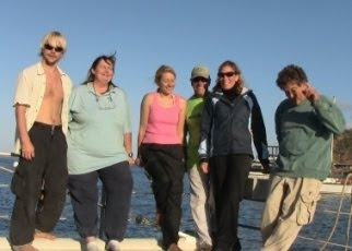 Day 29 Monday 10/5/09
When I woke for my last morning alone on the ORV Alguita, it was anything but. Gwen, who does the watch before me, decided to stay up with me due to the problems Lindsey and Jeff were having with the auto pilot. The wind kicked up to over 40 knots causing the auto pilot to fail. The only way to handle the situation was to change course, and if need be steer. There was no beating into the winds. It would also require a sail change from the genoa jib to the staysail, but the captain didn’t want to risk someone getting hurt or blown overboard by the assaulting winds so we traveled off course at 10 knots per hour getting nowhere fast. Bill, who comes on after my shift, was also up due to the outlandish banging under the ship. Few could sleep.
Gwen, who takes good care of this blogger, often times let me sleep in an extra 15 minutes. Today it was an hour. I didn’t change my watch when we sailed into the Pacific Daylight Saving Times yesterday so when I looked at my watch at 0345, I figured I was ahead of the game. It was actually 0445. Not letting on that I was late, nor did she try to wake me, Gwen had just started the tea pot on the stove for me.
Yesterday I was running late too, only that time it was because I was making my way out of the top bunk, a wave came and literally threw me. I fell out of my bunk 4” down landing on the top of my left toes (don’t ask). To add insult to injury I slammed into the side of Gwen’s bed, trashing my leg all in one full swoop. It took a minute for me to rub out the sting. The captain, who has something for everything, came out of his state room with some all natural salve that eases out bruises. It worked on my leg, but the middle toe on my left foot is perhaps broken. Ugg.
We rolled into Avalon, Catalina Island, with a circus show of several sea birds and sea lions. (they swam beside our boat as if so happy to see us!) 3,460 nautical miles later!!!
We walked around the island like drunken sailors though not having a drink. It’s called dock rock. Once on a boat for any length of time and then off, one feels the world rock when while off the boat! We met Faith in the restaurant we had dinner at tonight, a six year old Girl Scout who her and her older sister had accolades for the captain’s work on protecting the oceans. Great to meet both of you!!!
We’re rocking on the island and look forward to seeing everyone at the Algalita Headquarters tomorrow afternoon! Thank you Gwen, Cooper, Lindsey, Jeffy Pop and especially Captain Moore for an experience of a lifetime, but more importantly, allowing me to see the unseen, plastics accumulating in our defenseless ocean.
Hopefully I’ll see many of you tomorrow! Bonnie
Day 29 Monday 10/5/09
When I woke for my last morning alone on the ORV Alguita, it was anything but. Gwen, who does the watch before me, decided to stay up with me due to the problems Lindsey and Jeff were having with the auto pilot. The wind kicked up to over 40 knots causing the auto pilot to fail. The only way to handle the situation was to change course, and if need be steer. There was no beating into the winds. It would also require a sail change from the genoa jib to the staysail, but the captain didn’t want to risk someone getting hurt or blown overboard by the assaulting winds so we traveled off course at 10 knots per hour getting nowhere fast. Bill, who comes on after my shift, was also up due to the outlandish banging under the ship. Few could sleep.
Gwen, who takes good care of this blogger, often times let me sleep in an extra 15 minutes. Today it was an hour. I didn’t change my watch when we sailed into the Pacific Daylight Saving Times yesterday so when I looked at my watch at 0345, I figured I was ahead of the game. It was actually 0445. Not letting on that I was late, nor did she try to wake me, Gwen had just started the tea pot on the stove for me.
Yesterday I was running late too, only that time it was because I was making my way out of the top bunk, a wave came and literally threw me. I fell out of my bunk 4” down landing on the top of my left toes (don’t ask). To add insult to injury I slammed into the side of Gwen’s bed, trashing my leg all in one full swoop. It took a minute for me to rub out the sting. The captain, who has something for everything, came out of his state room with some all natural salve that eases out bruises. It worked on my leg, but the middle toe on my left foot is perhaps broken. Ugg.
We rolled into Avalon, Catalina Island, with a circus show of several sea birds and sea lions. (they swam beside our boat as if so happy to see us!) 3,460 nautical miles later!!!
We walked around the island like drunken sailors though not having a drink. It’s called dock rock. Once on a boat for any length of time and then off, one feels the world rock when while off the boat! We met Faith in the restaurant we had dinner at tonight, a six year old Girl Scout who her and her older sister had accolades for the captain’s work on protecting the oceans. Great to meet both of you!!!
We’re rocking on the island and look forward to seeing everyone at the Algalita Headquarters tomorrow afternoon! Thank you Gwen, Cooper, Lindsey, Jeffy Pop and especially Captain Moore for an experience of a lifetime, but more importantly, allowing me to see the unseen, plastics accumulating in our defenseless ocean.
Hopefully I’ll see many of you tomorrow! Bonnie
Más sobre Day 29
90: Return to Long Beach
 Thank you Algalita and friends for the warm welcome home. Marieta Francis and Jeanne Gallagher - you two were a sight for sore eyes. Along with many others including Jeff's parents, Kent and Kathy Ernst.

 containers, chip bags, bottles, and even a soccerball accompanied by a bottle. But the most disturbing was actually witnessing a seagull pecking at a floating plastic bag. "It looked like we were back in the gyre." Lindsey turned to me and said, "This is where it all starts." Thank goodness the Algalita supporters where out there to distract us. It was all too
  overwhelming to see so much trash in its origin- from land. It played out like a scene in "The Twilight Zone." I, personally, felt like our trip out into the gyre was some kind of victory, only to return to business as usual. The j
 aded twist to the end of our journey.
Más sobre Return to Long Beach
91: ORV Alguita Arrives in Long Beach!!!
 ORV Alguita and crew have returned safely to Long Beach, California after a successful research voyage. Thank you all for following along! In the photo below the crew receives their well deserved chocolate, chocolate cake.
 Here are links to read more about Alguita's arrival in the News:
- "Pollution study vessel returns to Long Beach" Press Telegram
- "Crew knows where the ocean trash goes" Daily Breeze
Más sobre ORV Alguita Arrives in Long Beach!!!