Lugares de interés (POIs) del Mapa
6: Navajo Life: Our Homeland
| The Navajos ancestral homeland covered parts of what is now Utah, Arizona, New Mexico and Colorado. The Navajo Nation is the largest Indian tribe in the US and is one of the few tribes which were able to hold on to most of their ancestral lands. Weblink:Navajo Nation  |
Más sobre Navajo Life: Our Homeland
8: Navajo Life: The Family Unit
Within their ancestral homeland, the Navajo, or Dine, lived in many small kinship (family) groups. While the Navajo identified themselves as a group of people separate from other tribes, Navajo men and women were primarily loyal and responsible to this family group.
| ||

Más sobre Navajo Life: The Family Unit
9: Navajo Life: The Hogan
The Navajo lived in shelters that provided for their physical needs and echoed their spiritual beliefs. The hogan, a round or conically shaped structure generally made of logs and packed with earth or plant material, is one of the types of shelter most frequently associated with the Navajo.
Source: "Western History/Genealogy Department, Denver Public Library " | ||

Más sobre Navajo Life: The Hogan
10: Navajo Life: Food & Clothing
Raising corn and livestock, especially sheep, was, and continues to be, an important part of Navajo culture. Sheep were an essential resource because they provided meat and wool for the Navajo. The painting below, by Frederic Remington, painted around 1888, depicts a Navajo shepherd with his sheep.
| ||

Más sobre Navajo Life: Food & Clothing
11: Navajo Life: The Four Sacred Mountains- Blanca Peak
| The Navajo people believe that their ancestors emerged into the place between four sacred mountains: Sisnaajini (Blanca Peak) in the east in what is now southern Colorado, Tsoodzil (Mount Taylor) in the South in what is now New Mexico, Dookooosliid (the San Francisco Peaks) in the west in what is now Arizona, and Dib Ntsaa (Hesperus Peak) to the north in what is now Colorado. According to their own history, the Navajos have always lived between these mountains. Mt Blanca is associated with the color white and represents dawn or the white shell.
Source: Wikimedia commons | ||

Más sobre Navajo Life: The Four Sacred Mountains- Blanca Peak
12: Navajo Life: The Four Sacred Mountains - Mt. Taylor
Mount Taylor or Tsoodzil, is known as the turquoise mountain. Mount Taylor marks the southern boundary of the Dine territory, and is associated with the direction south and the color blue.
Source: Wikimedia commons | ||

Más sobre Navajo Life: The Four Sacred Mountains - Mt. Taylor
13: Navajo Life: The Four Sacred Mountains - Hesperus Peak
Hesperus the Sacred Mountain of the North. Also known as DibNtsaa or Dibentsaa. It is associated with the color black.
| ||

Más sobre Navajo Life: The Four Sacred Mountains - Hesperus Peak
14: Navajo Life: The Four Sacred Mountains - The San Francisco Peaks
The San Francisco Peaks are known to the Navajo as the sacred mountain of the west. It is called Dokooosliid, which means Shining On Top, and is a place where medicinal herbs are collected for healing ceremonies. It is associated with the color yellow.
Source: Wikimedia commons | ||

Más sobre Navajo Life: The Four Sacred Mountains - The San Francisco Peaks
15: Historical Context: Lincoln, the Civil War, and Gold
After the Civil War began in 1861, the United States government sought greater control over New Mexico to protect gold shipments coming in from California and to guarantee that the area would not fall into Confederate hands. The government also wanted to secure valuable mining and grazing lands for white settlers. Source: Wikimedia commons, photo credit: Alexander Gardner |
Más sobre Historical Context: Lincoln, the Civil War, and Gold
17: Historical Context: The Gold Rush and Transcontinental Railroad
Throughout 1863 and1864, as important gold shipments moved east both overland and by sea, workers scrambled to construct the transcontinental railroad linking California to the East.
Source: Wikimedia commons (NO CREDIT)
Source: Wikimedia commons (NO CREDIT) | ||||


Más sobre Historical Context: The Gold Rush and Transcontinental Railroad
18: Historical Context: Navajo and US Tensions Increase
| Throughout the 1850s and into the 1860s, tension betweenthe Navajo and white settlers and soldiers had been constant. As Navajo lands and livelihoods were threatened by these outsiders, their normally peaceful relations, put strain on resources and the cultural differences between the two groups led to constant tension. After many soldiers were removed from the area to fight in the Civil War, conflict between the Navajo and settlers escalated. |
Más sobre Historical Context: Navajo and US Tensions Increase
19: Santa Fe
In 1862, Brigadier General James Carleton was given commandof the New Mexico territory. Carleton, like many non-Indians at the time, felt that the best way to resolve the conflict was to remove the Navajo to a reservation, where they would be taught to farm and learn Christianity. As a destination for the Navajo Carleton chose to create the Bosque Redondo reservation on the Pecos River in eastern New Mexico, including the military post of Ft. Sumner. Though many military officials warned the site didnt have sufficient resources, Carleton persevered with his plan and sent word to the Navajo leaders that they must surrendered by July 20, 1863.
| ||

Más sobre Santa Fe
20: Fort Defiance
In 1862, Brigadier General James Carleton was given commandof the New Mexico territory. Carleton, like many non-Indians at the time, felt that the best way to resolve the conflict was to remove the Navajo to a reservation, where they would be taught to farm and learn Christianity. As a destination for the Navajo Carleton chose to create the Bosque Redondo reservation on the Pecos River in eastern New Mexico, including the military post of Ft. Sumner. Though many military officials warned the site didnt have sufficient resources, Carleton persevered with his plan and sent word to the Navajo leaders that they must surrendered by July 20, 1863.
| ||
Más sobre Fort Defiance
21: Long Walk: “Kit Carson”
Noted trapper and scout Christopher "Kit" Carson was chosen to oversee removal of the Navajo from their homeland to Bosque Redondo.
| ||

Más sobre Long Walk: “Kit Carson”
22: Long Walk: Carson Raids
Carson and his approximately 700 soldiers, scouts andNew Mexico volunteers began a series of patrols through Navajo land, destroying Navajo crops, homes, watering holes and livestock in order to force the Navajo to surrender.
| ||||||||||||||||||||||||


Más sobre Long Walk: Carson Raids
23: Long Walk: Incident in Canyon de Chelly
In the book Dine: A History of the Navajo, Peter Iverson writes, "Albert H. Pfeiffer led an expedition through Canyon de Chelly in January 1864, taking as prisoners Dine who were 'half starved and naked.' Pfeiffer reported that he killed one Navajo woman 'who obstinately persisted in throwing rocks and pieces of wood at the soldiers'."
| |||||||

Más sobre Long Walk: Incident in Canyon de Chelly
24: Long Walk: The March Begins
From the holding camps, the Navajo were marched, with little food, clothing, shelter, or medical attention through unusually cold winter conditions over 300 miles to the Bosque Redondo. Three groups made the Long Walk throughout 1864, with over 8000 Navajo completing the strenuous journey to Bosque Redondo. Numbers vary as to how many Navajo died along the trail, but it may have been 200 or more.
| |||||||||||||


Más sobre Long Walk: The March Begins
25: Long Walk: Forced to Surrender
In the winter of 1863/1864, facing starvation and a result of the actions of Carson and his New Mexico volunteers, many Navajo decided to surrender to the U.S. government and were held at places like Fort Defiance, Fort Canby and Fort Wingate prior to the Long Walk.
| ||

Más sobre Long Walk: Forced to Surrender
26: Long Walk: Fort Defiance
The first group, already weak from months of hiding out from US troops, began the Long Walk at Fort Defiance in January, 1864. Fort Defiance was built by the US in 1849 in a lush, grassy valley containing springs and surrounded by high cliff walls in prime Navajo territory. This act initiated a series of clashes and attacks, but it was the Navajo who ultimately bid farewell to their homeland from the confines of this US barricade. The walk began in the midst of an unusually harsh winter and lasted roughly 300 days.
Painting, Seth Eastman, 1874: Fort Defiance Arizona Source: Wikipedia, uncopyrighted
| |||||||||


Más sobre Long Walk: Fort Defiance
27: Long Walk: Difficulties of the Walk
| The Long Walk was especially hard on the old and young. Sickness and death were common throughout the march. Raids by other tribes resulted in a shortage of food and the abduction of Navajo women and children. |
Más sobre Long Walk: Difficulties of the Walk
28: Long Walk: Passing Mt. Taylor
The passing of Mt Taylor was particularly difficult for theNavajo as it signified that they were leaving their homeland and entering an unfamiliar land.
| ||||||

Más sobre Long Walk: Passing Mt. Taylor
29: Long Walk: The Ordeal Continues
| From Mt Taylor it was still 250-315 miles (depending on route taken) to Bosque Redondo. They passed through the towns of Albequrque and Santa Fe and skirted the foothills of the Sangre de Cristo Mountains along the Santa Fe Trail until it met up with the Pecos River. The groups then followed the Pecos south to Bosque Redondo, past such views as this of Starvation Peak. |

Más sobre Long Walk: The Ordeal Continues
30: Utah Hideout: Refuge to the North
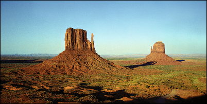
Utah plays an important part in the story of the Long Walk, as many Navajo were able to escape the Army raids. The secluded and difficult to reach areas now known as Southeastern Utah, though somewhat controlled by the opposing Ute tribe, made excellent places of refuge for the Navajo. For example, a Navajo man named Haskeneinii, who lived near Monument Valley was able to escape the advancing troops and live near Navajo Mountain for the next four years.
| ||

Más sobre Utah Hideout: Refuge to the North
31: Utah Hideout: Refuge to the North (cont.)
Many of the Navajo who escaped into Southeastern Utah were some of the richest and most important of the Navajo tribe. Though the Carleton and the U.S. Army were aware of the presence of these Navajo, and made half- hearted attempts to get various groups of these escaped Navajo to surrender, the fact that the Army already faced overcrowding and supply issues, in addition to the fact that these escapees were often economically and militarily strong made them hesitant to force the issue. However, continued conflict with the Ute did cause problems for these groups.
| Copyright 2006 Gigapxl Project | |||||||
Más sobre Utah Hideout: Refuge to the North (cont.)
32: Utah Hideout: Paiute Strip
| Another factor that allowed the Navajo to survive both Ute and U.S. Army raids was their cooperation with the Paiute bands who also lived in this area. The Paiutes were especially useful allies, because they often helped to mediate conflict between the Navajo and Ute. In fact, this area of Navajo territory is referred to as The "Paiute Strip" |
Más sobre Utah Hideout: Paiute Strip
33: Utah Hideout: Manuelito and the Restoration of Land
| Through the efforts of leaders such as Manuelito, some Navajo were able to survive and avoid being forced to move east. These Navajo continued to fight the soldiers and settlers who attempted to force them off their land. In addition, because of the Navajo presence in Utah, in 1933 this area was restored to the Navajo as part of the Navajo Reservation. Manuelito
| ||||||||||


Más sobre Utah Hideout: Manuelito and the Restoration of Land
34: Unsettled: Life at Bosque Redondo
Once the Navajo reached Bosque Redondo, they found miserable conditions. Poor planning by Carleton, a feud between the Army and the Bureau of Indian Affairs, unfamiliarity with how to prepare the food provided, bad water, and crop destruction due to weather and insects. This all led to a lack of food and shelter for the Navajo at Bosque Redondo.
| ||

Más sobre Unsettled: Life at Bosque Redondo
35: Unsettled: Problems at Bosque Redondo
| ||||

Más sobre Unsettled: Problems at Bosque Redondo
36: Unsettled: Crying for the Canyons
In 1965 a Navajo man named Grey Eyes discussed what it was like for his ancestors at Bosque Redondo, "The people were going to be herded to Ft. Sumner, and the people were cornered. They were herded into tight places where they couldn't get out anymore -run away anymore. ...And the people were crying for the Canyons. I don't know how many people were killed. And the food killed some of them -they didnt know how to prepare it. And many died from sicknesses, and others from large sores (infections), and many died from fever."
National Archives, Washington D.C. | ||

Más sobre Unsettled: Crying for the Canyons
37: Return Home: Treaty of 1968
| In June 1868, in response to Navajo petitions and a concern over conditions at Bosque Redondo, a treaty was signed that allowed the Navajo to return to a reservation in their ancestral lands. That month, the first group of Navajo left Bosque Redondo for their new reservation in their ancestral homelands. |
Más sobre Return Home: Treaty of 1968
38: Return Home: Returning to a Way of Life
| Though the Navajo had participated in large-scale farming and had lived in large settlements while at Bosque Redondo, once they returned to their homeland they resumed their traditional lifestyle, including living in small groups and practicing their own cultural traditions. |
Más sobre Return Home: Returning to a Way of Life