A map of the mountain bike trails in Middle Tennessee surrounding Nashville, TN. Updated 01/26/2012.Each marker is placed at the exact location of the trail head.For up-to-date trail conditions on each of the trails, visit: http://nationalmountainbike.com/board/forumdisplay.php?f=3
| 0: Hamilton Creek Ver detalle |
| 1: Lock 4 Ver detalle |
| 2: Shutes Branch Ver detalle |
| 3: Longhunter Ver detalle |
| 4: Chickasaw Trace Ver detalle |
| 5: Montgomery Bell Ver detalle |
| 6: Fairview Ver detalle |
| 7: AEDC Ver detalle |
| 8: Tim's Ford Ver detalle |
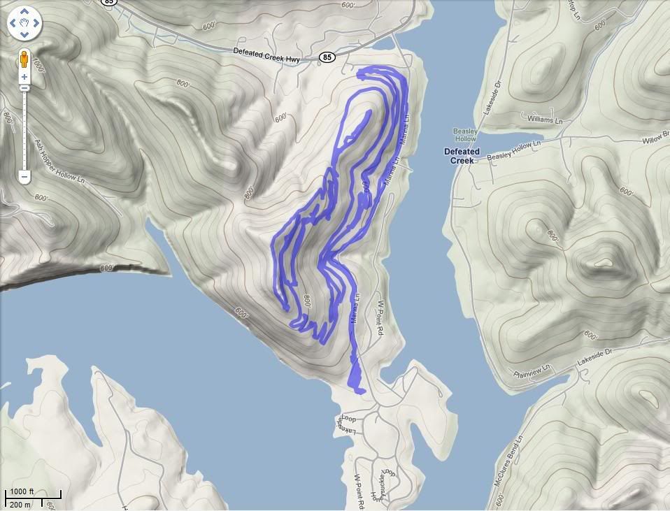
| 9: Defeated Creek Ver detalle |
| 10: Rotary Park Ver detalle |
| 11: Franklin State Forest Ver detalle |
| 12: Racoon Mountain Ver detalle |
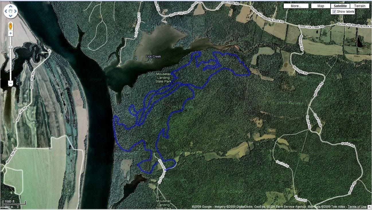
| 13: Mousetail Landing Ver detalle |
| 14: LBL (Land Between the Lakes) Ver detalle |
| 15: Lake Barkley Ver detalle |
| 16: Sewanee Parimeter Trail Ver detalle |
| 17: Tanasi Mountain Bike Trail System Ver detalle |
| 18: Chilhowee Mountain Trails Ver detalle |
| 19: Tsali Recreation Area Ver detalle |
| 20: Cotton Mill Reserve Ver detalle |
| 21: Fall Creek Falls Ver detalle |
| 22: TTC (Trials Training Center) Gravity Park Ver detalle |
| 23: Windrock DH Ver detalle |
| 24: Enterprise South Ver detalle |
There are twoloops, the "lakeside" loop, which is 5 miles long, withtwists, turns, rocks, roots, and a few hills....and a longer, bit more advanced 6.5 mile loop. Both trails are quite hilly, withplenty of layered rocks, roots to ride over, and a few trees to cross.
Hamilton Creek is considered one of the more "technical" trails here inNashville. The longer trail is basically just more of what the shorteris, with a one longer climb, and a long downhill section with largerocks, roots, trees, etc...great for honing technical skills. The trailis closed when wet.
Hamilton Creek Trail Map - Trail Map - PDF Format, 1.8 MB.
This 8.5 mile trail is considered a great scramble trail. Don't let thelength scare you away. It's more of a riding trail than a technicaltrail. The singletrack is twisty and narrow at times with some 4X4roads for high speed.
Yellow arrows mark the main trail. Since the park is on a peninsula,it's hard to get lost, although you may repeat parts of the trail ifyou don't pay attention. The trails are well maintained by the Lock 4Trailblazers. Closed when wet.
Lock 4 Trail Map - JPG Format, 245 Kb.
4.5 miles of beginner to intermediate single track with new trail construction underway.
Total trail expected to be 7.5 - 9.5 miles when completed.
Park MAP (Jones Mill Trail on this Map)
Chickasaw issuitable for all levels of Mountain Bike riders - from expert racers to5-year-olds. Several sections of trail have been identified with thesigns being constructed and installed through an Eagle Scout project.The trail is a 7.75-mile serpentine loop.
If ridden in a clockwise direction from the trailhead at the MTBparking lot, the initial four miles are relatively flat and follow KnobCreek and the Duck River. Upon entering the "Trail of Tears", the finalfour miles become very difficult, also known as "technical" amongMountain Bike enthusiasts. The course is designed with severalentry/exit points so that a rider can pick the parts of the trail thatsuits him or her.
Trail Map: HERE
Maps of the course are also available at Columbia Cycling Club's signlocated at the Mountain Bike parking field.
Fairviewis extremely fun to ride as it can be challenging and fast or easy andslow. You can tell this multi-use trail was created by Mountain bikersas the numerous bridge crossings, log stacks and other fun additionsmake this fun.
The only thing this trail lacks is a better mapand clearly defined loop options. It seems 2 or 3 rides and you'll getit down.
Fairview Trail Map - PDF Format, 300 Kb.
For more details including a trail map and points of interest, visit the Tim's Ford Google Map.
Tim's Ford is an out and back with a lot of steep climbing (will get youin shape quick) and super sweet single track. Park at the visitorscenter and follow the paved bike trail until it dead ends and then takea right on the trail.
There has been about a mile or two added to the upper loop. Get out andride it in!! It's pretty twisty and has some very steep switchbacks.And it goes by a huge sinkhole - no cave though. This is one cool trailon a 300 ft high ridge side. We did the upper loop once and the lowertwice for 11.3 miles. If you haven't ridden this trail, you should. Ithas the most relief of any trail in Mid-TN. Tim's for is a close second(but I think it actually has more total climbing).
Trail Map:
HERE
The trail actually has about 6 miles of trail tooffer. The trails are only marked in certain areas but all of thetrails are easily found. There is an area where the locals are puttingtogether some stuff for the freeride crowd and each of the obstaclesstill have a way to get around them if that isn't your thing. If youare in the clarksville area and are jonesing for a ride. It's there.
http://www.friendsofrotarypark.blogspot.com/
The Raccoon Mountain Mountain Bike Trail Network is located just 15minutes west of downtown. The trail network currently offersapproximately 17.5 miles of intermediate and advanced single track.However, plans are underway to more trail, hopefully doubling theamount of single track in the next few years.
Trail MAP:
HERE
There are two trails here that can both be started from this point, the North Welcome Station.
The Canal Loop is an 11 mile single-track loop. Trail information and Map HERE
The North-South trail is a out and back and is 31 miles each way. Trail information and Map HERE
For more information on Land Between the Lakes visit the main website HERE.
Around 14 miles of singletrack with a few hike-a-bike sections.
Trail Map HERE.
Check out Woody's bike shop if your in the area.
The Tanasi trailsystem is about 11.5 miles and is located near the Ocoee White Water Center (4400 Old CopperRd/ 4400 Highway 64) in the Cherokee National Forest. The trail systemconsists of mostly machine-cut singletrack loops that are connectedtogehter by forest service roads. No visit is complete without ridingthe Riverview Loop trail or decending the Thunder Rock Express trail,one of the best down hill cross country mountain bike trails in thestate.
Details here:
http://www.fs.fed.us/r8/cherokee/recreation/trails_bike.shtml
Azalea Trail #141
Beginner/1.5 miles
This ride is fun for beginners and experts alike, with fast narrowsingletrack leading mostly downhill (if you start across the lowercampground road). You can use this trail to connect up with the rest ofthe system or just as a short loop back to the campground area.
Benton Falls Trail #131
Moderate/1.5 miles
This wide track leads from the lake to the waterfall. Watch for hikers and be respectful.
Clemmer Trail #302
Advanced/1.5 miles
4.5 miles on Benton Falls Trail to the junction of Trail #302
A classic screaming downhill or a gut wrenching uphill (depending onwhich direction you ride it). Clemmer has it all: several creekcrossings, rhododendron tunnels and surfaces ranging from sandy torocky. The high end of the trail is at the beautiful Benton Falls(accessible from a short hiking trail.)
Clear Creek Trail
Advanced/3+ miles
One of the most challenging trails in the system; be ready for somekiller climbing, 3 extreme switchbacks, one of which is just barely butnot impossible to ride. Be very careful especially in the middle ofthis trail where there is a fairly steep rock cliff area. Near the end,be ready for an extremely fast downhill with some wonderful whoops tofly off of. There are a couple of options at the end of this downhilldepending of how wet you want to get.
Rim Extension
Moderate/0.4
A short technical sidetrail.
Slickrock Trail Loop
Advanced 3+ miles
A sweet trail system which is actually a small network of trails hookedtogether by a couple of old Forest Service Roads. You will findsingltrack with climbing twists and turns and some fun downhills withwhoopde-doos. One section has been unofficially named Naked Widow Loop.This stems from several sightings of an elderly woman bathing in thesmall creek at the middle of the branch. Legend has it she lived withher husband on the Benton side of the mountain when her husband died,whereupon she began to endlessly wander the trails.
Trail map HERE.
Over 39 miles of arguably the best mountain bike riding in the southeast.
For maps and more information, go here:
http://www.mtbikewnc.com/trailheads/tsali.html