Lugares de interés (POIs) del Mapa
0: Wadi Al-'Arabah
Wadi Al-â??Arabah, or the velley of Al-â??Arabah is a topographic depression extending 160 kilometers south of the Dead Sea though gulf of the Red Sea. It is of tremendous Islamic significance because when the first caliph of Prophet Mohammad made the decision to invade greater Syria through Palestine, his first step was to secure the region of Wadi Al-â??Arabah. It was a series of battles that gave the Muslim army control over the valley, hence marking a region as opposed to a single location.Source: Encyclopedia Britannica, 15th edition.
Más sobre Wadi Al-'Arabah
1: Wadi Al-'Arabah
Wadi Al-â??Arabah, or the velley of Al-â??Arabah is a topographic depression extending 160 kilometers south of the Dead Sea though gulf of the Red Sea. It is of tremendous Islamic significance because when the first caliph of Prophet Mohammad made the decision to invade greater Syria through Palestine, his first step was to secure the region of Wadi Al-â??Arabah. It was a series of battles that gave the Muslim army control over the valley, hence marking a region as opposed to a single location.Source: Encyclopedia Britannica, 15th edition.
Más sobre Wadi Al-'Arabah
2: The Great Mosque (Al-Omari Mosque)
The Great Mosque is considered one of the oldest yet grandest mosques in the region. Located in the heart of downtown Gaza, the Mosque spreads over an area of 4100 m2, placing its gate within a walking distance from the local market. Perhaps one of the most interesting and controversial aspects of this mosque, however, is that unlike typical mosques, this one was built on the ruins of an Idol worshiping temple and a Christian Church. Source: Virtual Tourist â?? Gaza Strip Travel Guide
Más sobre The Great Mosque (Al-Omari Mosque)
3: Old Akko City/SeaPort
It might be true that other seaport cities do exist on the shore of historical Palestine; however, none of their ports had the efficiency of Akkoâ??s harbor. The reputation of this port started when the Muslim forces occupied Akka as a strong foothold to capture greater Syria. Once it fell, the Muslim forces rebuilt its harbor, transforming Akka from a being just another seaside city into the major crossing point for all caravans headed to the Arabian Peninsula, Bilad Al-Sham, and Northern Africa. Following this transformation, however, all hegemonic powers in the region felt the need to control this sea-port, most notably of which was Napoleon Bonaparte in the 18th century. Source: This Week In Palestine periodical, www.thisweekinpalestine.com
Más sobre Old Akko City/SeaPort
4: Old Hebron Suk
The city of Hebron is another example of a well preserved suq culture. The Old City of Hebron with its maze shaped alleys and tin covered booths provide a very authentic feel of what the original bazaar might have looked like. The products offered are not limited to one sort; they actually covers most needs of an average individual living in Hebron whether being it today or fifteen hundred years ago. Examples of such merchandise include olivewood, glass, pottery and even dried fruits. Source: www.AtlasTours.net
Más sobre Old Hebron Suk
5: Mosque of Omar
In the year 638, Omar b. Al-Khattab visited Bethlehem as an envoy of prophet Mohammad. When the time for praying came, Omar walked a short distance (across Manger Square) and prayed on an empty piece of land. In the year 1860, Omarâ??s praying site was donated by the Greek Orthodox Church to the Muslims of Bethlehem, and the Mosque was built. As the only Muslim shrine of worship in the city, the Mosque of Omar serves mainly as a symbol of religious co-existence, as well as a convenience for Muslim residents of Bethlehem.Source: www.AtlasTours.net
Más sobre Mosque of Omar
6: Nabi Musa Shrine/Mosque
This structure is believed to be built over the tomb of Prophet Moses, although the biblical text suggests that Musa was buries on an unidentified the opposite side of River Jordan. The generally accepted story according to Muslim tradition claims that Saladin had a dream which revealed to him where Moses was venerated, subsequently; he built a Mosque in that location so that Muslims can be blessed by who they consider to be a Muslim Prophet. What initially was a simple shrine/mosque expanded over the succeeding Muslim dynasties; in 1410, a hospice and a minaret were added, and in the Turks reign, they restored the building and encouraged a seven-day pilgrimage there, were they days are spent praying, feasting and playing games.Source: www.AtlasTours.net
Más sobre Nabi Musa Shrine/Mosque
7: Old Nablus Suq
Located at the bottom of Mount Gezarim, the Old City of Nablus is home to families at the lowest end of the economic scale. The highly dense home of 20â??000 inhabitants still retains many of its authentic suq characteristics such as old-fashioned soap factories and Turkish baths. In the past, a combination of several wars and destructive earthquakes lead to the destruction of nearly the entire city. However, during the second half of the 13th century, it was renovated by the Mamluks, and ever since then, the rejuvenated city established itself as the main source of cotton, soap, and sweat pastry for the entire region of Palestine.Source: Municipality of Nablus website www.nablus.org
Más sobre Old Nablus Suq
8: Hisham's Palace
Hishamâ??s palace is thought to be built during the Umayyad rein in Palestine, particularly at the time of Calipha Hisham, the 10th Umayyad Caliph to rule the Islamic Empire, and arguably the last dominating representative of that dynasty. Because the palace was never completely built, it was forgotten and covered in sand until British archeologists discovered it in the year 1937. The structure shows itself shows some figural representations of early Islamic art, however, the dome and some of the decorations of the palace reflect Christian, Byzantine and Persian influences.Source: www.AtlasTours.net
Más sobre Hisham's Palace
9: Redwan Palace
The Redwan Palace was build during the reign of the Redwan family, which extended from the start of the Ottoman rule until the seventeenth century. Similar to several other historical testaments of a once thriving Gazan economy; the palace displays inscriptions, Islamic drawings and decorations carved in wallâ??s stones. Interestingly, the Rewan palaceâ??s is commonly mistaken for Napoleonâ??s castle because he used the palace as a temporary command center during the French invasion of Acko in 1799. Source: Municipality of Gaza website www.MoGaza.org
Más sobre Redwan Palace
10: Sayyed Hashem Mosque
The Sayyed Hashem Mosque is one of the largest and most notable ancient Mosques in Gaza. The reason behind such unusual level of interest in this mosque can be perceive from its name. Sayyed Hashem is said to be Hashem bin Abdal-Manaf, Prophet Mohammad's grandfather who died in Gaza during a trading journey, and the mosque is believed to be build there so that Sayyed Hashemâ??s tomb is located right underneath the dome of the mosque. Source: Municipality of Gaza website www.MoGaza.org
Más sobre Sayyed Hashem Mosque
11: Battles of Ramla
The city of Ramla is strategically located on the main road connecting Jerusalem to Ashkelon, while the first was under the control of the Crusaders; the latter was the largest Fatimid fortress in Palestine. As a result, the site of Ramla witnessed not one, but several battles between the competing empires (1101, 1102, 1105 CE). Additionally, during the Caliphate rule in palestine, Ramla became the new capital of Jund Filastin.
Más sobre Battles of Ramla
12: Battle of Yarmouk - year 636
Battle of Yarmouk was named after the River Yarmouk where it took place. In this battle, the Muslim army defeated the Byzantine forces of Theodore the Sacellarius Baänes, forcing the emperor Heraclius to move from Antioch to Constantinople. The significance of this battle for the Islamic Empire is based on its location; Palestine was considered the first and major line of defense Defeating. The defeat of the Byzantine army on the border of Palestine and Jordan represented the fist step of conquering the rest of greater Syria.
Más sobre Battle of Yarmouk - year 636
13: Ashkelon - The City and the Battle
150 years after the Crusades first attacked Palestine, the only uncaptured city was Ashkelon. Although a modern Israeli city does exist nowadays, it is located a few kilometers north of the old city of Ashkelon. Remains of forts can barely be seen around the place mark. Due to Ashkelonâ??s strategic location, the Crusaderâ??s siege had very little effect the strength of the Muslim forces; they continuously received funds, ammunition, and food from the Fatimids in Egypt. Eventually, the city fell â?? due to increased internal fighting â?? in the year 1099 CE.Source: The Palestinian Information Center - www.palestine-info.co.uk/am/publish/article_14.shtml
Más sobre Ashkelon - The City and the Battle
14: Kaysariyya (modern day Caesarea)
After securing Ghazza and achieving a victory Battle of Adjnadayn, the Islamic forces marched against Kaysariyya and established a siege for the second time in a row. Although historical accounts vary on who was in command when the forts of Kaysariyya were captured, the generally accepted version claims that Amr b. Al-Asi departed to Egypt shortly after taking up the siege again, leaving his successor Yazid b. Abi-Sufyan in charge, who in turn died and was succeeded by his brother Muawiya b. Abi-Sufyan. Kaysariyya was captured, the story continues, in the year 19 under the command of Muawiya.
Más sobre Kaysariyya (modern day Caesarea)
15: Battle of Ain Jalut
Battle of Ayn Jalut "Spring of Goliath" â?? near modern day NazarethThis location is where the two expanding Kingdoms of Mamalik from the West and Mongols from the Right crossed paths, resulting in the inevitable battle to decide who will rule the region of northern Palestine. Although this battle was not the first loss of the Mongol army, it was considered a first that the defeated Mongols did not return later on to recapture it, thus relinquish the region to the Mamluk control.Source: Encyclopedia Britannica, pp 417
Más sobre Battle of Ain Jalut
16: Ibrahimi Mosque
This religious structure is said to be build on the cave containing the tomb of the prophet Abraham and his family. According to Muslim religious texts, since Abraham is revered as prophet of Islam, Muslims view this site as highly sacred. Following the Palestinian-Israeli negotiations known as the Wye River, the Ibrahimi Mosque became a Waqf property to be managed by Muslim representatives. Source: Wikipedia
Más sobre Ibrahimi Mosque
17: Battle of Hittin
Following the defeat of the Muslim dominion in the region on the hands of the Crusaders, the notion of Jihad or Holy War was restored, and the Muslim leaders who were once competing to rule the region joined powers against the dominating Crusade forces. The Battle of Hittin (1187) exemplified the peak of the revived Muslim forces, as it was the first step towards recapturing the region of Palestine, starting with Hittin. Synonymous with this battle is the name of the General leading the Muslim forces; Salah Al-Din Al-Ayyoubi, who â?? following this victory â?? marched towards Jerusalem, capturing every Crusade stronghold on the way. Source: Encyclopedia Britannica, pp 416.
Más sobre Battle of Hittin
18: Battle of Adjnadayn
The battle of Adjnadayn All the literature on the battle of Adjandayn states that the specific location of the battle is unknownâ?¦ Most sources say that it is named after the site were the battle took place, which according to Wikipedia and Britannica Encyclopedia is located 30 km West-Southwest of Jerusalem. According to the Encyclopedia of Islam, this battle took place somewhere between Ramla and Beit Djibrin. Based on this information, I placed the marker on this location. The battle of Adjnadayn had a decisive effect on the control of Palestine. Under the leadership of Amr b. Al-Asi and Khalid b. Al-Walid, the Muslim army clashed with the Byzantine forces trying to protect their rein in the region of historical Palestine. Taking place on July 30th 634, accounts of this battle describe it as exceedingly bloody and gruesome; although it ended with a decisive Muslim victory, it took more senior Muslim figures to achieve this victory than any other battle in the conquest of Syria. Aboce all, the strategic location of Adjnadin opened the door for the Muslim forces to move into the rest of Palestine.Source: The Encyclopedia of Islam, pp 910-911
Más sobre Battle of Adjnadayn
19: Al-Qastal Battle
Al-Qastal Battle: The battle of Al-Qastal is names after the village in which it took place. Currently, the village was captured by the Jewish militia to secure the way in and out of Jerusalem, which at the time was surrounded by Arab forces. After the village was secured by the Jewish forces, several volunteers under the command of Abd al-Qadir al-Husseini launched a counter attack in an attempt to restore the strategic location. Al-Qastal became especially well-known mainly because it is the battle in which the prominent guerilla leader Abd al-Qadir al-Husseini was killed.
Más sobre Al-Qastal Battle
20: Mosque al-Tuteh
The oldest mosque in Aleppo, al-Tuteh means "mulberry tree". The western side of the building incorporates the Roman triumphal arch that marked the beginning of the main east-west thoroughfare, the decumanus.
Más sobre Mosque al-Tuteh
21: Bab Antaki "Antioch Gate"
It is interesting to see how the heavy traffic stops abruptly as one crosses from the modern to the old city. The defensive walls mark out the boundary of old Aleppo, while modern Aleppo sprawls outside. In fact, accurate archeological information about Aleppo sites is hard to come by -- the city is possibly the oldest continually inhabited city in the world (condending for the title with larger, cosmopolitan Damascus) and the presence of people living around and using ancient structures prevents the sort of in-depth archeological survey which could be done in an abandoned city. I've marked by name only the other gates of the walled city, to make the old walls obvious. The Antioch gate in particular is noteworthy -- it was constructed in the 13th century by the Ayyubid governorn al-Nasr Yusuf II (r. 1242-60), and it was re-constructed in the 15th century. Some of its stones may have come from the original roman walls and gateway. It is through this gate (rather, the gate which stood on this spot in 637) that the conquering Arab armies entered Aleppo for the first time.
Más sobre Bab Antaki "Antioch Gate"
22: Bab al-Hadid
"The Iron Gate", was planned by (again) al-Zahir Ghazi, but built by his son Mohammad, and named at that time Bab al-Qanat, or Aqueduct Gate. This gate was built over again by the last Mamluk sultan, in 1509. According to this cryptic source, "It holds an unknown shrine within its walls". http://www.archnet.org/library/sites/one-site.tcl?site_id=5287
Más sobre Bab al-Hadid
24: Bab al-Nasr
"Victory Gate", this entrance to the old walled city was originally called Bab Yahud, or Jewish Gate, because of its proximity to the old Jewish quarter. It was rebuilt by, and named by al-Zaher Ghazi in 1212, and Ghazi's gate became the most important northern entrance to the city. Reconstructed again by the Ayyubids, the gate incorporates two 90 degree turns, making the gate practical for military defense, but less practical for modern traffic. During the Ottoman period the double-wall was edited to make way for carriage traffic -- the road the gate is on was a major thoroughfare at the time.
Más sobre Bab al-Nasr
26: Armenian Orthodox Church of 40 Martyrs -- Jdeide Quarter
This triangle-shaped quarter, "New Quarter" appeared in the late Mameluke period, (1500s), in response to the Armenian Orthodox and Maronite Christian workers brought to Aleppo by the Venetians' trading operations with Europe. It is interesting compared to the wider Muslim areas of Aleppo because in quite a small area are many churches -- not strange compared to the density of mosques, but strange considering they are all of "competing" and mostly mutually exclusive sects, which, I would suppose, define an individual's identity greater than whichever mosque happens to be in your neighborhood would. The book Monuments of Syria describes the buildings of this quarter as exemplifying domestic architecture of the period -- the building focuses on a central courtyard, with a fountain or pool, and has a sharp split between downstairs "public" rooms and upstairs "private" rooms for the family. However, most of these buildings are owned by charitable or commercial interests, and are difficult for any random traveler to get inside. The Armenian Orthodox church, The Church of Forty Martyrs is the spot the marker is actually over -- it
Más sobre Armenian Orthodox Church of 40 Martyrs -- Jdeide Quarter
27: Great Mosque of the Citadel
The courtyard walls of this mosque are covered in beautiful mosaic. The courtyard itself is dominated by an ornate covered fountain, but it also contains what looks like a box on sticks -- the "treasury" -- when this structure was built, it was considered the safest possible place for valuables.
Más sobre Great Mosque of the Citadel
28: Glacis
It was mentioned in the general "Aleppo Citadel" marker, I wanted to clarify that the glacis is the smoothly graded hill that makes the citadel so difficult to attack â?? it has an angle of 52 degrees to the horizontal, in places. Paving portions of the glacis with stone was undertaken by Saladin's son al-Malik al-Zaher Ghazi in the late 1200s.
Más sobre Glacis
29: Great Mosque
This mosque was founded in 715, though the building began life as a Roman temple, an unknown number of years earlier. Unlike the Umayyad mosque of Damascus, this mosque has been destroyed (by earthquake and fire) and rebuilt several times, loosing much of the distinctive Umayyad architecture style. The only thing that distinguishes the mosque as Umayyad is the fact that it was orignially built by Umayyads, and its original floor plan. The courtyard is famous for its black and white stone pavement, clearly visible in the satellite photo. I assume this was a later addition to the mosque, but while major reconstructions happened under the Ayyubids in 1159, and after the Mongol invasion in 1260, the date of the courtyard paving has remained elusive. Inside the mosque is a shrine to Zachariah, father of John the Baptizer, and an elaborately carved minbar from the 15th century. Tangentially, I like how it is possible to pinpoint photographs taken in the courtyard of this mosque, because the tile pattern on the ground is so clear in the satellite photo.
Más sobre Great Mosque
30: Khan al-Sabun
The entrance gateway to this khan "The Soap Khan" is considered one of the greatest examples of Mameluke architecture in Aleppo, according to Monuments of Syria. It was constructed in the late 15th century by the governor Adzemir. The central building, which the marker is directly over, is a warehouse, built later. Like the Great Mosque nearby, this khan is effectively connected to the suq complex, geographically and conceptually. Nowadays, most of these medieval travelers' hotels (there are many, most not architecturally or historically striking) have been turned into storage space and workshops for various trades, since they are conveniently connected to the suqs.
Más sobre Khan al-Sabun
32: Madrasa Halawiye
Built over the 6th century Cathedral of St. Helen, it was a welfare institution before it became a school.
Más sobre Madrasa Halawiye
33: Masyaf
http://users.stlcc.edu/mfuller/Medieval/Masyaf.html According to this source (the satellite photo is too grainy to make out even a building) at this site stands a fortress which was the center of Isma'ilism in Syria, in 1140, behind the charismatic leader Sinan. In 1176, the castle was besieged by Saladin -- an apparently paradoxical act for the leader of military Islam during the Crusade, but the choice of Aleppo as a strong hold against the Europeans was not only because Northern Syria is a convenient bottleneck on the way from Europe to Jerusalem, but because heresy -- especially Isma'ilism and its variants were so rampant, the Sunni leadership had to crack down.
Más sobre Masyaf
34: Madrasa Moqaddamiye
The oldest madrasa in Aleppo. Like many early Islamic buldings, it was originally a church, and was converted into a religious school after the city was retaken from the Crusaders in 1124 -- the inscription is dated 1168 -- as poetic justice, echoing the Muslim victory over the Christians.
Más sobre Madrasa Moqaddamiye
35: Northwest Minaret, Great Mosque
Though portions of monuments (Fatimid, Antique, or Umayyad) exist reused in objects built later, this minaret is the oldest wholly preserved monument in the entire city. It was built in the early years of the Seljuk occupation of Syria, but not by the Seljuks: the powerful chief judge of the city had begun the construction project before the Seljuk governor ever heard about it. It's style is a return to the pre-Islamic style native to northern Syria.Allen, Terry. 2003. "Great Mosque of Aleppo". In Ayyubid Architecture. Occidental, CA: Solipsist Press. http://www.sonic.net/~tallen/palmtree/ayyarch/ch2.htm#alep.gm
Más sobre Northwest Minaret, Great Mosque
36: Qalaat al-Kahf
http://users.stlcc.edu/mfuller/Medieval/AlKahf.html Between 1164, and 1190, this was supposedly the headquarters of Rashid al-Din Sinan, called the "Old Man of the Mountain" in Christian sources. While it seems a long way from Aleppo, the influence of charismatic Sinan extended across Northern Syria. Ibn Jubayr writes, as he is leaving Aleppo, "Beyond... are the mountains of Lebanon, of towering height and great length, extending along the sea coast. On their slopes are castles belonging to the heretical Isma'ilites, a sect which swerved from Islam and vested divinity in a man. Their prophet was a devil in man's disguise called Sinan ... He bewitched them with these black arts, so that they took him as a god and worshiped him ... reaching such a state of obedience and subjection that did he order one of them to fall from the mountain top he would do so." While Ibn Jubayr's account is colored by prejudice, he has his facts right -- the Assassins, or the Nizaris, as this particular Syrian group of Isma'ilites is called, after Nizar al-Mutansir, who died attempting to claim the Fatimid kingdom. The Nizaris believed that Nizar was indeed not dead, and would return with (or as the man himself) the Mahdi, a superpowered savior figure, greater than Muhammad, that would bring about the end of time.
Más sobre Qalaat al-Kahf
37: Ayyubid Palace
Built by the Ayyubid ruler in 1230, the hammam, or baths area was recently restored, but the greatest part of the structure has lain in ruins since it was destroyed by the Mongols.
Más sobre Ayyubid Palace
38: Suqs
This entire area -- the light gray with periodic dots -- is a covered suq. More properly, it is several covered suqs, but they run together at the edges. Satellite photos fail to do justice to what is underneath the roof. "Monuments of Syria" devotes a section to Aleppo's suqs and khans, and says, "The suqs of Aleppo which form a labyrinth totaling 7 km in length are unsurpassed in the Middle East for sheer interest and atmosphere. Largely unchanged since the 16th century (some go back as far as the 13th), they preserve superbly the atmosphere of the Arab/Turkish mercantile tradition. The maps split up the suq into trade areas, where particular goods can be found, but if they were to be all labeled, they would outnumber labeled mosques 3 to 1. Everything from cotton to lawyers is traded in the suq. Ibn Jubayr mentions the covered suq, though the current stone complex is after his time, the buildings he saw were made of wood. It is interesting to note that the Great Mosque is all but surrounded by the suq â?? in fact the only way to get into the mosque is through the suq.
Más sobre Suqs
39: Mosque of Abraham
This building is attributed to Nur al-Din in 1167. The centerpiece of the mosque/shrine complex is the stone on which Abraham was supposed to have sat, as he milked his favorite cow -- a story which is the origin of Aleppo (properly, Halab)'s name. This site was previously a church, which was the supposed burial place of the head of St. John the Baptizer -- the supposed head was moved to this site in 435 from Baalbek, and remains to this day. You can tell that the mosque was built over an already existing church plan -- the later structure exists on the south wall -- it lines up with the Great Mosque of the Citadel, which also points toward Mecca -- the older church building is skewed several degrees clockwise.
Más sobre Mosque of Abraham
40: Portugese Naval Battle
This was the location of a naval battle in 1513 battle in which Portugese admiral Albuquerque attacked Aden with 20 ships. The admiral was defeated and the Portugese were unable to take the valuable port city.
Más sobre Portugese Naval Battle
41: Aquaduct
This aquaduct was built by the British in the 1800's when they were using the Port of Aden. They were essentially occupying the Port by force but they paid the Sultan a small fee in order to be able to say that they were not actually an occuping force. The British recieved permission from the Sultan before they built the aquaduct.
Más sobre Aquaduct
42: Shamsan
Shamsan is the modern name for the extinct mountain that helped create Aden. Shamsan's peak is 1775 feet high and used simply be called the mountain. Shamsan has greater significance because its volcanic activity is the reason there is a belief and a reference to fire coming from Aden in the Hadith.
Más sobre Shamsan
43: Soviet Naval Base
After World War II and at the beginning of the Cold War the Soviet Union established an important Naval Base in the Port of Aden. The Soviets were able to this primarily because of thier connection to the South Yemen liberation force that had communist ties during the Yemenis civil war. The port was very valuable to the Soviets because of its strategic position in the Middle East and its proximity to North Africa.
Más sobre Soviet Naval Base
44: Peaks of Muzalkam and Ihsan
The peaks of Muzalkam and Ihsan are the major peaks in the main geographic and topical landmark in Aden. These peaks seperate the city of Aden and Little Aden. They also protect the city of Aden from the harsh Southeast winds and more the city more comfortably livable.
Más sobre Peaks of Muzalkam and Ihsan
45: Reservoirs of Al-Taweelah
The reservoirs of Al-Taweelah are the most famous of the old reservoirs in Aden. There was over fifty reservoirs throughout Aden but the reservoirs of Al-Taweelah are the most famous of them all. Even with all the reservoirs many times they still had problems getting enough water and the British later remedied this problem by building an aquaduct after they occupied the port of Aden in the 19th century. The reservoirs of Al-Taweelah are a popular tourist attraction today.
Más sobre Reservoirs of Al-Taweelah
46: al-Maksir
Al-Maksir was a bridge that was built to connect the then Island of Aden to the main land. Aden became an island when the seas would rise and cover the isthmus. The bridge was built by the Persians but damns have been built since then to further remedy the problem of flooding.
Más sobre al-Maksir
47: Trade protecting wall
This was a wall built by the Zuray'ids to protect their trade interests. Later the Zuray'ids following leader increased the size of the wall dramatically and the wall only had six gates so that travel could be heavily controlled.
Más sobre Trade protecting wall
48: First Church in Aden
This church was built in the time of Constantine when the Roman Empire began to regain its glory. The Church was built by bishop Theophilus around the year 342. The church and much of the city of Aden was abandoned after ports in the Red Sea gained importance.
Más sobre First Church in Aden
49: Mountain Paths
These mountain paths were created by early inhabitants of Aden to get to other parts of Aden and Little Aden. Later these paths through the mountains were used by officials National Liberation Force after the Yemenis civil war when they were trying to live Aden, or at that time, South Yemen.
Más sobre Mountain Paths
50: Little Aden
Little Aden is a small city on the other side of the peaks of Muzalkam ad Ihsan. It is located on the other west side of the Bay of Aden at the mouth of the harbor. Its location makes it key to protecting and regulating the port.
Más sobre Little Aden
51: Attack on USS Cole
On October 12, 2000 in the port of Yemen a small ship exploded next to a United States Naval carrier. The explosion killed 12 United States sailors and wounded many more. The event was a terrorist attack directed towards the United States. The attack was initially believed to be carried out by the Islamoc terrorist group al- Qaeda, but was later proven to be perfomed by a different extremist organization.
Más sobre Attack on USS Cole
52: Western Gate of Aden
The Western Gate of Aden is a gate leading into the Tunnels of Aden. The gate was the best way for merchants to get to the important trade area of Crater. The arch that symbolized the gate was torn down in the Mid 1900's.
Más sobre Western Gate of Aden
53: Mosque of Abban
The Mosque of Abban is located in Crater and is one of the oldest and one of the most famous mosques in Aden. It has become one if the most important historical landmarks as well as one of the most significant Islamic landmarks in the city.
Más sobre Mosque of Abban
54: Lighthouse of Crater
The lighthouse of Crater is arguably the most popular and significant landmark and tourist attraction in Aden. The lighthouse is the trademark of the important market area of Crater and was important functionally for the new port of Aden in its early years.
Más sobre Lighthouse of Crater
55: Tunnels of Aden
The tunnels of Aden allowed traders to travel to the trade area of Crater. Merchants would take their camels through the protected tunnels for easy and safe passage. At one time some of the tunnels were also used as prisons.
Más sobre Tunnels of Aden
56: Crater
Crater is the oldest and most populated area of Aden. It has the oldest and most famous mosques in the city and has three markets that are the most profitable and most crowded in the city. Crater is the economic hearland of the economic capital of Yemen.
Más sobre Crater
57: New Harbor
The new harbor is a more protected and larger version of the old harbor that was located at the eastern side of Aden. The port is the main reason for Aden's importance in the region. It is still an important trade port and has served as a military port for the British in the 1800's and early 1900's, the Soviets during the Cold War, and it has served as a United States naval refeuling station.
Más sobre New Harbor
58: Mole
This mole was an obstruction that was built in an effort to protect the old Aden harbor from the harsh Southeast winds. The mole was an important part of the old port's success.
Más sobre Mole
59: Old Harbor
The old harbor was the main reason for Aden's success as an early city. The port was later moved to the more secure Northwest location later on. The port served as an important economic resource and was the main reason the city changed hands so much in the years following the spread of Islam.
Más sobre Old Harbor
60: Funduq
The funduq was a common feature of medieval Islamic cities, and was usually composed of at least two floors of rooms arranged around a central courtyard. Funduqs provided traveling merchants with accommodation and storage space for goods and animals. As a midpoint betweent the cities of northern Morocco and the vilages in the mountains to the south, the funduqs of Marrakesh were central locations where goods, tribes and ideas mixed. Parker, Richard. â??A Practicle Guide To Islamic Monuments in Morocco.â? Charlottesville: The Baraka Press, 1981. 59.
Más sobre Funduq
61: Gueliz
The Gueliz or "new town" was designed by the French during their involvment in Morocco. Wide streets and detached houses that are very visible from the street provide a stark contrast between the narrow winding paths and hidden houses of the old city. www.ilovemarrakech.com
Más sobre Gueliz
62: Aït Benhaddou
At the base of the Atlas Mountain lies a small cluster of earthern buildings surrounded by high walls. This tiny fortress on a hilltop is known as a ksar and dates back many centuries. As one of the only surviving traditional pre-Saharan settlement, it is a prime example of southern Moroccan architecture. This picturesque village has been featured in many films including Gladiator, Jesus of Nazereth, Lawrence of Arabia, and Alexander. www.lexicorient.com
Más sobre Aït Benhaddou
63: Hammam el Basha
The hammam, a Moroccan version of the Roman and Turkish bath, is part of daily life in Marrakesh. Full of very hot water and special rhasoul scrub. Muslims modified their use to ritual ablutions before prayer in the mosque, often situated adjacent to the hammam. Large mosques have their own hammam complexes. Natives visit these baths atleast once a week, usually on Thursday or Friday morning before prayer services. www.fdors.com
Más sobre Hammam el Basha
64: Souks
Next to the Jemma el-Fna square, the souks is where the city breathes. Narrow streets twist through a labrynth of animated and determined shopkeepers. The various souks include Souk Chouari which offers weavings, baskets and wood sculpting. The Souk des Bijoutiers specilizes in jewelry while Souk el Attarine sells all types of perfumes and oils. Similar ventures gather in specific districts of the medina. Marrakesh is known for having the largest traditional souk in all of North Africa and the Middle East. Parker, Richard. "A Practicle Guide To Islamic Monuments in Morocco." Charlottesville: The Baraka Press, 1981. 59.
Más sobre Souks
65: Badia Palace
Built in the 16th century with in the original Qasba of Marrakesh, this was the main residence of Saadian sultan Ahmad b. Muhammed al-Shaykh al-Mansur. Once known as "the Incomparable," the palace was the pinnacle of luxury for its day. The palace's symmetrical plan consists of chambers and pavilions arranged around a large central courtyard. Four large gardens surround the central enclosure. Constructed from brick, the entire palace is adorned with ornate tiles, marble columns, carved stucco and carved wood ceilings. In the late 17th century, Alawid ruler Moulay Ismail ordered the destruction of the palace and the estate is still in a state of disrepair. Parker, Richard. "A Practicle Guide To Islamic Monuments in Morocco". Charlottesville: The Baraka Press, 1981. 59.
Más sobre Badia Palace
66: Bab el-Debbagn
Designed in the Moorish style, this gate has marked the domain of the tanners. The complex S- shaped gate was built by the Almoravids but rebuilt many times. For thousands of years, tanners in this neighborhood have been using the same technique. Skins are immersed in tanks and unfortunately give off an odor that matches the vividness of the dyes. Parker, Richard. "A Practicle Guide To Islamic Monuments in Morocco." Charlottesville: The Baraka Press, 1981. 63.
Más sobre Bab el-Debbagn
67: Qasba Mosque
Built thirty years after the Koutubia, it was planned to be a large congregation mosque for the palace complex that Yaqub al-Mansur built within the Qasba walls. The shabka motif is introduced on the minaret which is unique to Almohad designs. The green tile is decorated with geometric and floral abstractions. Parker, Richard. â??A Practicle Guide To Islamic Monuments in Morocco.â? Charlottesville: The Baraka Press, 1981. 61.
Más sobre Qasba Mosque
68: Bab Agnaou
Built in 1150 when the Almohads completed the fortification of the Medina, this gate is among the oldest of the 18 gates. There is a high central arch framed by interlacing lobed arches decorated with carved vegetal motifs and kufic inscriptions. This stone gate illustrates the grandeur and detail of 12th century Almohad architecture. Originally, this was the main entrance to the Almohad Palace. During the Almohad period, this was the only gate through which rubb or boiled, sweetened grape juice could be brought into the city. Thus, it is also known as Bab ar-Rubb. Parker, Richard. â??A Practicle Guide To Islamic Monuments in Morocco.â? Charlottesville: The Baraka Press, 1981. 62.
Más sobre Bab Agnaou
69: Menara Airport
Located about 4 miles southwest of Marrakesh, the airport offers flights to Casablanca, Paris, London, Geneva and Amsterdam.www.virtualtourist.com
Más sobre Menara Airport
70: Palace of Congress
Meeting Hall and Event Center outside the walls of the old medina. About 823,000 people live in Marrakesh as reported by a 2004 census.
Más sobre Palace of Congress
71: Bab Khemis
This large gate is located on the northeast edge of the medina. A busy Thursday market or Suq al-Khemis is held here every week. The inside door supposedly came from Spain as a gift from Yusuf bin Tashfin, the first Almoravid sultan.Parker, Richard. â??A Practicle Guide To Islamic Monuments in Morocco.â? Charlottesville: The Baraka Press, 1981. 63.
Más sobre Bab Khemis
72: Bahia Palace
The Bahia Palace is a relatively young complex when compared with the surrounding city. Built in 1894 by Moroccan architect Muhammad al-Mekki, it was to be a gift for Ahmed ibn Moussa, the son of the grand vizier. It is set in extensive gardens and features the key elements of Moroccan architecture - light, symmetry and water. The rooms vary in size, but each has its own quiet courtyard. The whole building features carved-cedar ceilings, ceramic-tiled walls and fountains, shiny marble finishes, stucco cornices and decoratively painted (zouak) ceilings.Hill, Derek. "Islamic Architecture in North Africa." Hamden: Archon Books, 1976. 127.
Más sobre Bahia Palace
73: Menara Gardens
Heading west from the Bab el-Jedid, a long avenue ends in the Menara Gardens. Vast palm groves flank a serene pool of in the center of the garden. This cite is one of the most photographed places in Morocco and is usually bustling with tourists. Despite the large crowds that the gardens attract, there is still a peaceful and expansive element that keeps natives and tourists coming back year after year. Designed as a summer escape, the orchards and olive groves are perfect for a late evening stroll. The Pavilion was reconstructed in the 19th century by Sultan Adu r-Rahman. www.lexicorient.com
Más sobre Menara Gardens
74: Majorelle Gardens
A refuge from the heat and chaos of the souks, the Majorelle Gardens enchant visitors from all over the world. Owned originally by the French painter Jacqes Majorelle in the 1940's, the small rooms and lush gardens served as an inspiring art studio. The buildings are painted a surreal shade of azure. This vivid blue color gave the gardens the nickname "Blue Majorelle." The careful landscape has unique North African plants and intricately decorated fountains. Currently, the gardens are owned by the French fashion designer Yves Saint Laurent. The former painting studio has been converted into a Museum of Islamic Art which features a priceless collection of ancient works of Middle Eastern art. The gardens are open to the public and are a sharp blue contrast within the red city. www.virtualtourist.com
Más sobre Majorelle Gardens
75: Saadian Tombs
The Saadian Tombs are located in the Riyad al-'Arus quarter just outside the south rampart. Pavilions or Qubbas mark the tombs of Saadian rulers from the 15th and 16th centuries. The first chamber honors Muhammad al-Shaykh while the second honors Ahmad al-Mansur who died in 1603. While these individuals are the most well known, over sixty members of the royal family are in the mausoleum. In following centuries when the rest of Marrakesh was being ransacked by Moulay Islmail, the tombs were left untouched. Local superstitions about the Tombs prevented defilement. Parker, Richard. "A Practicle Guide To Islamic Monuments in Morocco." Charlottesville: The Baraka Press, 1981. 50.
Más sobre Saadian Tombs
76: Royal Palace
Created in the 12 th century by the Almohad sovereign, Abd al-Mumin, and subsequently enlarged by the Saadians, this estate was the main residence of Marrakesh royalty. Now closed to the public, the Palace houses emaculate tile mosaics, wood carvings and also luxurious gardens. Only the outerwall is accessible to the public. The wall and door offer a small glimpse into what lies behind them. With a majestic pointed arch and grand wood doors, the building exemplifies the grandure of Moroccan royaltly. Motifs in green, blue and white surround the door but there are not any inscriptions in Arabic. Parker, Richard. "A Practicle Guide To Islamic Monuments in Morocco." Charlottesville: The Baraka Press, 1981. 59.
Más sobre Royal Palace
77: Medina
The medina or old city of Marrakesh was founded in 1062 by Yusuf ibn Tashfin who was member of the Almoravides dynasty. At it's conception, Marrakesh served as a millitary camp for troops traveling from the Atlas Mountains to the south up to the larger towns in northern Morocco. The ramparts that surround the city were built in the 12th century by Ben Yusuf who wanted to protect the city from the threat of invasion. www.medloc-maroc.com
Más sobre Medina
78: Koutubia Mosque
The Koutubia Mosque marks the heart of Marrakesh and the imposing minarets can be seen from every part of the city. Build out of pink sandstone from the quarries in the surrounding hills, the minaret changes shades of orange and pink as the sun crosses the sky. The tower is over 220 feet tall and is crowned by four large spheres. According to legend, they were originally made of pure gold, and there were once supposed to have been only three. The fourth was donated by the wife of Yacoub el Mansour as compensation for her failure to keep the fast for one day during the month of Ramadan. She had her golden jewelry melted down, to fashion the fourth globe. Constructed in 1160 by the Almohad ruler 'Abd al-Mu'min, this hall-type mosque is the largest of its kind and can house over 25,000 Muslims for prayer services. The term Koutobia was applied to the mosque due to the book sellers who set up there stalls in this area of town. Hill, Derek. "Islamic Architecture in North Africa." Hamden: Archon Books, 1976. 125-6. Hutt, Antony. "Islamic Architecture: North Africa." London: Scorpion Publications, 1977. 41.Parker, Richard. "A Practicle Guide To Islamic Monuments in Morocco." Charlottesville: The Baraka Press, 1981. 59.
Más sobre Koutubia Mosque
79: Mosque of Bab Doukkala
This mosque was built in 1557 by Mas'uda bint Ahmad, the mother of the sultan Ahmad al-Mansur. The orginial plan of the religious structures have not been changed since the Marinid period. It features more than six domes and seven naves. Hill, Derek. "Islamic Architecture in North Africa." Hamden: Archon Books, 1976. 127.
Más sobre Mosque of Bab Doukkala
80: Mouassine Mosque
The Mouassine Mosque was built in the 16th century by the Saadians on land formerly occupied by the Jewish community. There is a fountain that has three sections - two for animals and one for humans. The most notable features are the three huge doorways and the intricately carved cedar ceilings. This mosque is closed to non-Muslims.Hill, Derek. "Islamic Architecture in North Africa." Hamden: Archon Books, 1976. 123.
Más sobre Mouassine Mosque
81: Marrakesh Museum
The palace dates to the end of the 19 th century, and was built by the vizier of Moulay Abd al-Aziz. Considered on of the loveliest palaces of Marrakech, the building was converted to a museum in 1932. It now houses pottery, ornaments, weapons, carpets and other artifacts that vividly narrate not only the history of Marrakesh but also Moroccan life in general. www.marrakeshguide.com
Más sobre Marrakesh Museum
82: Medrasa Ben Youssef
Named after the Almoravid sultan Ali bin Yusuf, the school complex was built in the 14th century by the Merindid dynasty. One of the largest theological colleges in North Africa, the building houses up to 900 students. The private students are aranged in clusters around a distinctive courtyard known as a duwiras. The main courtyard has a large central pool that is intrecately adorned with geometric patterns. Parker, Richard. "A Practicle Guide To Islamic Monuments in Morocco." Charlottesville: The Baraka Press, 1981. 57.
Más sobre Medrasa Ben Youssef
83: Mosque Ben Youssef
The Almoravid rulers originally built this mosque adjacent from the first medrassa. There is a minaret over 40 meters high with a roof of glazed green tiles. The structure has been redone so many times that the original architecture is no longer recongnizable. Only Muslims are allowed into this mosque.Hill, Derek. "Islamic Architecture in North Africa." Hamden: Archon Books, 1976. 127.
Más sobre Mosque Ben Youssef
84: Place Jemaa el Fna
Place Jemaa el Fna is the heart of the Red City. The largest and most authentic sub-Saharan market in Morocco. The bustling square changes from fresh produce and orange juice stands in the morning to a prominent evening location for street performers and nightlife. Snake charmers, jugglers, and various ventures croud this small, oddly shaped area to entertain travelers and visit with locals. www.ilovemarrakech.com
Más sobre Place Jemaa el Fna
85: Chez Ali
Chez Ali presents local "fantasias" which feature traditional horse races and authentic Moroccan meals. In tribal costumes, dancers, jugglers and magicians portray life as it was when Marrakesh was the capital of northwestern Africa. This is a great place to experience traditional Moroccan culture. www.emi.ac.ma
Más sobre Chez Ali
86: Almoravid Qubba
This small rectangular pavillion of stone, brick and cement has a large dome. Also known as a cupola, this seemingly insignificant building is rich in regional historical importance. It is the only complete building from the Almoravid period to survive intact in Morocco. This is the only place in Morocco that non-Muslims can see Almoravid-Andalusian decorative motifs in their original setting. According to the inscription, the Qubba was constructed in 1107 and was part of the ablutions complex of a grand mosque previously located on this site. The large dome is a uniqe structure with a carved stucco ceiling featuring a symmetrical floral motif. An inscription on the interior of the building is one of the oldest example of cursive script rather than angular Kufic script. Parker, Richard. A Practicle Guide To Islamic Monuments in Morocco. Charlottesville: The Baraka Press, 1981. 59.
Más sobre Almoravid Qubba
87: Ramparts
The ramparts were built in the 12th century by the Almoravids. Over 12 miles of thick red wall surrounds the city. Instead of concrete, a red, finely filtered mixture of sand and lime was used. Eighteen doors or Babs offer access into and out of the medina. www.lavillanomade.com
Más sobre Ramparts
88: Masjid Hannana Mosque
I am pretty sure this mosque is Masjid Hannana. There is a story that as Hasan and Husayn were carrying the body of 'Ali from Kufa to Najaf, they passed near this mosque. As they were passing, the pillars of the mosque inclined towards 'Ali as if bowing down and paying it's last respects. Also, it is said that a piece of Husayn's face is buried here. This mosque is directly between the Great Mosque of Kufa and 'Ali's tomb, and so 'Ali's body probably would have passed through here, making this mosque a good canidate.(http://www.al-islam.org/ziyarat/iraq.htm)
Más sobre Masjid Hannana Mosque
89: A Mosque
It is unclear what mosque this is. However, this is obviously a mosque because of the large minaret and dome. Also, the building is facing towards Mecca, a sure sign of a mosque.
Más sobre A Mosque
90: Masjid Kufa
I think that this is Masjid Kufa, the mosque in which 'Ali was murdered and martyred. It is also the mausoleum of other martyrs. It is hard to tell the mosque's exact location, but this mosque looks quite similar to some pictures I have seen.(http://www.al-islam.org/ziyarat/iraq.htm)
Más sobre Masjid Kufa
91: Husayn's Tomb
This mosque/tomb is the final resting spot of Muhammad's grandson, Husayn. He was on his way to become caliph in Kufa when he was massacred and killed. The day he was killed is a day of mourning for Shiites. This tomb is the third most holy sites to Shiites, and it is a pilgrimage spot for millions.(www.pbs.org/wnet/wideangle/shows/iran/map2.html)
Más sobre Husayn's Tomb
92: Battle of Nahrawan
This area might be where 'Ali fought and beat the rebel Kharijites. The Kharijites fought for 'Ali during the Battle of Siffin, but on the way back to Kufa they rebelled and stationed themselves in Nahrawan. After the Kharijites attacked some of the inhabitants, 'Ali marched his remaining troops to Nahrawan to stop the Kharijites. Because he was hesitant to fight what once were allies, 'Ali offered any Kharijites his protection if they joined his side. Many did, except for about 1,800 men. 'Ali's large army easily defeated them. I think this is where the battle happened becasue 'Ali had to cross the Tigris river, and he was heading toward Syria from Kufa when he stopped at Nahrawan.(http://en.wikipedia.org/wiki/Battle_of_Nahrawan)
Más sobre Battle of Nahrawan
93: The Great Mosque of Kufa
This mosque is on the site of the original 7th century mosque of Kufa. This was the center of the original war camp founded by S'ad. It has been updated and expanded many times throughout it's history.(http://www.archnet.org/library/sites/one-site.tcl?site_id=7590)
Más sobre The Great Mosque of Kufa
94: Husayn's Massacre
This general area is the place where 'Ali's second son, Husayan, was massacred by the Umayyads on his way to Kufa. The people of Kufa were going to help him claim his right to the caliphate, but the Umayyads stopped and slaughtered him and his small band of family members and followers. The massacre would have happened around the west side of Karbala because they were heading to Kufa from the north west.(http://i-cias.com/e.o/husayn.htm)
Más sobre Husayn's Massacre
95: Euphrates River
The Euphrates river would have been very important to Kufa for trade and irrigation. The Euphrates runs for 1,700 miles through Iraq and the Middle East.
Más sobre Euphrates River
96: Battle of the Camel
The Battle of the Camel was the first documented occurance of Muslim vs. Muslim fighting. 'Ali was once again defending his legitimacy to his title of caliph. I believe the battle happened near here because it happened only a few miles outside of Basra, and 'Ali would have been coming from the north.(http://en.wikipedia.org/wiki/Battle_of_the_Camel)
Más sobre Battle of the Camel
97: The Battle of Siffin
The famous Battle of Siffin might have taken place here. The outcome of the Battle of Siffin split apart all of Islam into Sunnis and Shiites. 'Ali marched from Kufa to meet Mu'awiya for battle and to secure his position as caliph. It ended in the "Arbitration at Adhruh" which weakened 'Ali's power. I believe it took place here because it happened near the Euphrates and past the border of modern Syria.(http://en.wikipedia.org/wiki/Battle_of_Siffin)
Más sobre The Battle of Siffin
98: 'Ali's tomb
This is the site of the fourth caliph and the first Imam 'Ali's tomb. Also known as Imam 'Ali Mosque. It is located in An-Najaf, which is only a few miles from Kufa. This mosque is a popular pilgrimage spot for Shiites.(http://en.wikipedia.org/wiki/Imam_Ali_Mosque)
Más sobre 'Ali's tomb
99: Somewhere in the Western Mountains
According to the legend of Sana'a, Moses' son, Shem, was looking for a place to found a city and decided on someplace in the Western Mountains before a bird picked up his marker and flew off with it. Taking it as a sign from God, Shem followed the bird and built instead where the bird finally dropped the marker (where Sana'a is now).
Más sobre Somewhere in the Western Mountains
100: Medina
Muhammad sent govenors to Sana'a from Medina to spread Islam in Yemen in the early 600s. The real sucess of the spread of Islam did not come directly from the governors, though, but from the conversion of the Persian governor Badham in 628.
Más sobre Medina
102: Aden
Aden, the sister city of Sana'a, sent goods through Sana'a and then to Mecca. Also, when Aden was taken over by the British in 1839, the Ottomans wanted to insure that the British wouldn't have a monopoly on trade in the Red Sea. This is their main motivator for opening up the Suez Canal in 1869. This move by the Ottomans in turn led to their second occupation of Sana'a (from 1872 to 1912).
Más sobre Aden
103: Suez Canal
The icon is where the Suez Canal connects with the Red Sea. The Suez Canal opened in 1869 and allowed the Ottmans to enter the Red Sea for trade which led to their second occupation of Sana'a (from 1872 to 1912).
Más sobre Suez Canal
104: al-Hudaydah
A port city established by the Ottomans when the Suez Canal opened (in 1869). When there was political unrest in Sana'a, its merchants called upon the nearby Ottomans for help (as political strife is bad for buisness). This led to the second Ottoman occupation of Sana'a (from 1872 to 1912).
Más sobre al-Hudaydah
105: Tihama Coastal Plains (southern tip)
This area along the coast (to the other Tihama icon) was taken by the Ottoman Turks in order to persuade the Imam to allow them to enter and bring more stability to Sana. The Imam agreed but the Ottoman troops were killed by the people of Sana'a who didn't approve of their presence.
Más sobre Tihama Coastal Plains (southern tip)
106: Tihama Coastal Plains (northern tip)
This area along the coast (to the other Tihama icon) was taken by the Ottoman Turks in order to persuade the Imam to allow them to enter and bring more stability to Sana. The Imam agreed but the Ottoman troops were killed by the people of Sana'a who didn't approve of their presence.
Más sobre Tihama Coastal Plains (northern tip)
107: Ta'izz
In 1948 the Imam Yahya was killed but his son Ahmad escaped only to return and reclaim Sana'a with the help of Zaydi tribesmen from the Northern Highlands of Yemen. He then let the Zaydi tribesmen (200,000 people) loot Sana'a and its people of anything of any value- including doors! (as a way to avenge the fact that the people of Sana'a did not rise up to help). After this Ahmad changed the capital from Sana'a to Ta'izz. The capitol swiched back to Sana'a after the civil war (1962 to 1970) that eventually ended the line of Imams.
Más sobre Ta'izz
108: Sa'da
Sa'da is the city where Zaydism first began in 897 and took over Sana'a in 901. The Imams that controlled Sana'a for most of its history were from the Zaydi sect and had to constantly appeal to the tribesmen of the Northern Highlands of Yemen that Sa'da is a part of.
Más sobre Sa'da
109: Djabal Nukum
This mountain (zoom to about 15 miles) helped protect Sana'a- which used to be used as a military base of pre-Islamic civilizations.
Más sobre Djabal Nukum
110: The Qasr al-Silah Fort
This fortress was rebuilt when Islam came to Sana'a in the 600s and is still intact today. The Imam Ahmad needed to take over this fort in 1948 to stand any chance of reclaiming power in Sana'a.
Más sobre The Qasr al-Silah Fort
111: Old Sana'a
The area within the main streets surrounding this icon is Old Sana'a. Sanaa didn't start expanding outwards (to what it is now) until the 1970s (Lonely Planet).
Más sobre Old Sana'a
112: Remains of City Wall (northern part 1)
Sana'a used to be a fortified city which meant that it (old Sana'a) was surrounded by a wall. In 1962 this wall was totally intact but in the matter of a few years later sections were starting to get torn down for the sake of expansion. The wall was originally made with mud but in 1990 some resoration work has been done using stone. The wall can be identified here as a series of line segments connected with half-crescents. Find the other icons of the wall to see the other half of the remains.
Más sobre Remains of City Wall (northern part 1)
113: Remains of City Wall (southern part)
Sana'a used to be a fortified city which meant that it (old Sana'a) was surrounded by a wall. In 1962 this wall was totally intact but in the matter of a few years later sections were starting to get torn down for the sake of expansion. The wall was originally made with mud but in 1990 some resoration work has been done using stone. The wall can be identified here as a series of line segments connected with half-crescents. Find the other icons of the wall to see the other half of the remains.
Más sobre Remains of City Wall (southern part)
114: Remains of City Wall (northern part 2)
Sana'a used to be a fortified city which meant that it (old Sana'a) was surrounded by a wall. In 1962 this wall was totally intact but in the matter of a few years later sections were starting to get torn down for the sake of expansion. The wall was originally made with mud but in 1990 some resoration work has been done using stone. The wall can be identified here as a series of line segments connected with half-crescents. Find the other icons of the wall to see the other half of the remains.
Más sobre Remains of City Wall (northern part 2)
115: Site of Qalis
...directly to the left of the icon (zoomed in at 8000 ft). This is the site where the famous cathedral of Sana'a used to be until it was destroyed when Sana'a converted to Islam (via the conversion of the Persian governor, Badham, in 628). Some of its stones were used to build the Great Mosque.
Más sobre Site of Qalis
116: Al-'Aquil Mosque
...directly to the left of the icon. Unlike the other mosques pictured, the roof of this one looks tan and not white. It has a minaret that is lighted up and looks very bright at night (Lonely Planet).
Más sobre Al-'Aquil Mosque
117: Salah ad-Din Mosque
...directly to the left of the icon. This mosque was built in a purely Yemeni style (while most other mosques in the area show Turkish influences in their style).
Más sobre Salah ad-Din Mosque
118: Qubbat al-Bakiriya Mosque
...directly to the left of the icon. This mosque was completed durring the first Ottoman occupation of Sana'a and then restored durring the second Ottoman occupation. Because it is directly accross from a wide street, it is probably the easiest of all the mosques to look at from a distance (Lonely Planet).
Más sobre Qubbat al-Bakiriya Mosque
119: The Great Mosque of Sana'a
When Sana'a officially converted to Islam with the conversion of the Persian governor, Badham, in 628, churches and palaces were destroyed and their stones were used to create this Mosque.
Más sobre The Great Mosque of Sana'a
120: Qubbat Talha Mosque
...directly to the left of the icon. This mosque has some Turkish influences.
Más sobre Qubbat Talha Mosque
121: Al-Mutwakil Mosque
The building directly to the left of the icon is the mosque. This mosque was built in the early 1900s by the Imam Yahya.
Más sobre Al-Mutwakil Mosque
123: Suq al-Miln
In this area is the famous Suq (market) in Sana'a. Literally means "The Salt Market" even though salt is not among it's large commodities. The suq used to have a central samsara (a place where money and expensive items are stored) but ever since the Imam Ahmad let Zaydi tribesmen sack and loot Sana'a in 1948 (and thereby taking revenge on the people of Sana'a for not coming to his aid when an attempt was made on his life) there are now 40 separate sub-suqs- each with their own samsara.
Más sobre Suq al-Miln
124: Qat Suq
This is a more modern market that mostly sells Qat (a plant that contains stimulants). Most adults from Yemen chew Qat for at least five hours a day (http://ag.arizona.edu/~lmilich/yemen.html) aA wall also surrounds this Suq (Lonely Planet).
Más sobre Qat Suq
125: Ar-Raqqah
At the end of the 12th century, Harran teamed up with ar-Raqqah as residence to Ayyubid princes.
Más sobre Ar-Raqqah
126: Site of The Battle of Harran
Some believe that the battle took place here, in the plain opposite ar-Raqqah. Others believe it to have happened in Balikh Valley, Turkey, and Matthew of Edessa believes the battle was fought two days away from Harran. This battle was fought during the Crusades on May 7, 1104, and was one of the Crusaders' first defeats, proving that the Muslims weren't invincible. Fighting were the Principality of Antioch and the County of Edessa against the Seljuk Turks.
Más sobre Site of The Battle of Harran
127: Euphrates River
Thanks to the Euphrates River and its reservoirs, the Harran Plains are now irrigated and growing cotton. The Euphrates is approximately 1,730 miles long and originates here in Turkey and flows all the way through Iraq.
Más sobre Euphrates River
128: Ataturk Reservoir
This reservoir, from the Euphrates River, helps to irrigate the crops of cotton in Harran located downstream.
Más sobre Ataturk Reservoir
129: Harran Plains
The plains of Harran, which were significantly more barren over ten years ago, are now green, fertile, irriagted, and abundant with cotton.
Más sobre Harran Plains
130: Grand Mosque
Built in the 8th century, later restored and enlarged in the 12th century. This mosque is known to be the oldest in present-day Turkey.
Más sobre Grand Mosque
131: Sumatar
This is a pagan sanctuary consecrated by the Sabians (later to inhabit Harran). Located in Sumatar is the Moon God Sin's Temple.
Más sobre Sumatar
132: The Mosque and Tomb of Cabir El Ensar
Cabir El Ensar was Mohammad's companion, fought many wars with him, and fought for the conquest of Damascus after Muhammad's death. A mausoleum and mosque were built here, where he lost an organ during the conquest of Sanliurfa and Harran.
Más sobre The Mosque and Tomb of Cabir El Ensar
133: Harran
Harran was a main stopping point for the three traveling men mentioned in Ury's article. Harran is the home of the Harranian Sabians, the oldest mosque in Turkey, and also home to Abraham during his journey to the Promised Land. While in Harran, God promised Abraham a great nation and commanded him to leave his family behind and He would lead him to a new land (Canaan).
Más sobre Harran
134: Schechem
Upon arriving in Canaan, Abram stops here in Schechem. God appeared to Abram here and he built an altar.
Más sobre Schechem
135: Ur, Iraq
One of the stops on the three men's travels (Ury). This was supposedly the starting point of Abraham's journey on his way to Canaan, the Promised Land. Also located in Ur is Sin, the Moon God's, other chief seat of worship along with his main one in Harran.
Más sobre Ur, Iraq
136: Land of Canaan
This area, spread across present-day Israel, West Band and Gaza, plus parts of Lebanon and Syria. This marks the endpoint for Abraham's journey; this is the Promised Land, where he enters into a covenant.
Más sobre Land of Canaan
137: Urfa
This was the starting point for the three men of different Abrahamic faiths, written about in Ury's article, who followed in Abraham's footsteps to Canaan, stopping in Harran on the way, as Abraham did. Abraham was born here.
Más sobre Urfa
138: Location on Path to Jerusalem
Other than its trading port, Antioch was also a large milestone to the crusaders. It lay directly in the path to Jerusalem, the crusaders ultimate goal. Along with Aleppo and Damascus, Antiochâ??s position in the â??triangle of powerâ?? denoted it as a clear target for crusaders, and characterized it as a jewel of Northern Syria.
Más sobre Location on Path to Jerusalem
139: The Iron Bridge
Another important defense structure that shielded Antioch was the Iron Bridge, a large bridge built from impregnable metal with two towers rendered it perfect for the protection of the city. It was so strong in fact, it stood intact until 1972. Crusaders were able to defeat the 700 men that stood at the Iron Bridge before the first attack in 1097, a key aspect in the capturing of Antioch.
Más sobre The Iron Bridge
140: City of Artah
This small yet fortified city that lay about 20 kilometers outside of Antioch served primarily as a shield to Antioch against crusaders. It lay on the crossroads of three of the major cities at the time, making not only an important barrier for attackers, but as a place of diverse people and cultures as well.
Más sobre City of Artah
141: Walls
Built by the Christian emperor Justinian in the late 6th century, the walls of Antioch enclosed the city and provided it with solid protection. This fortification began at the bank of the River Orontes and led all the way up into the surrounding mountains that reinforced the city as well. However, due to Antiochâ??s location in an area prone to tectonic activity, earthquakes destroyed most of Justinianâ??s work, except the parts on the mountains, allowing modern tourists the opportunity to see their massive size and actualize the wallsâ?? importance in the amplification of Antioch as a city.
Más sobre Walls
142: Antakya Museum
This breathtaking museum holds some of the most magnificent and wondrous Roman mosaics known to mankind today. Most mosaics come from the town of Haribye, and portray scenes of mythological figures as well as house Roman and Islamic art as well. Although very almost brand new in nature, the museum serves as a unique bridge between Antiochâ??s progressive, 20th century vibe and its rich religious history that makes the city what it is today.
Más sobre Antakya Museum
143: Habib Neccar Mosque
This former Frankish Church turned mosque serves as one of Antiochâ??s most attractive and magnificent sites, even in modern times. Located in the older half of the city, it is regarded as a holy site in both Christian and Islamic religions. This mosque is said to be named after the event in the Qurâ??an involving the prophet Habib-ün Neccar. IT was redesigned by the Ottomans in the late 19th century and suffered a substantial earthquake. Itâ??s attractive minaret, however, still stands and serves as a symbol for its rich history, both in Islam and Christianity alike.
Más sobre Habib Neccar Mosque
144: The Bazaar Quarter
Due south of the St. Peterâ??s Church lies the Bazaar Quarter. This was and still remains a place of mixed culture and language, and exemplifies the cosmopolitan nature of the city. Notably, the Bazaar also stems out of the Islamic history of the city, making the feeling here generally more Arab and Muslim than Turkish and Christian.
Más sobre The Bazaar Quarter
145: St. Peterâ??s Church (Senipiyur Kilisesi)
Perhaps one of the most ancient structures in Antioch today is the smoke-blackened edifice of St. Peterâ??s Church. Its substantial position in the Christendom likely explains its importance both to the religion itself and Antiochâ??s history as well. Its construction, dating back to the early 11th century, makes it not only the oldest Christian church still in use today, but also denotes a significant historical story. It was here that the followers of Jesus Christ began to call themselves Christians, all being led by the apostle Peter. Built by Christian crusaders in the just before the turn of the 12th century, this landmark notes Antiochâ??s holy religious aura and shows the progressive nature of the city at the time, namely within the realm of Christianity.
Más sobre St. Peterâ??s Church (Senipiyur Kilisesi)
146: Port at Seleucia Pieria
The port on the Mediterranean Sea that lay about 15 miles down the Orontes from Antioch. It supplied the city with a great economy and a strategic place along the coast. However, this port also invited several attacks from Persia and surrounding areas. Therefore, the costs and benefits of this port are not far and between.
Más sobre Port at Seleucia Pieria
147: Mount Staurin
The peak in Antioch opposite Mt. Silpuis. When one entered the city, they were met by the gigantic force of this mountain. On it stood Justinianâ??s walls and still today stands a shrine to the apostle Paul.
Más sobre Mount Staurin
148: The city of Haribye (formerly Daphne)
This small grove of laurel trees served a considerable role in Antiochâ??s religious and cultural history. Characterized by glorious waterfalls, this location served as the marriage place of Cleopatra and Marc Antony as well as the favorite resort of ancient Antiochenes. It produced some of the most renowned Roman mosaics and was kept off limits in battle by both the Romans and the Muslims ruling the city. It has a strong importance mainly with the Byzantinian history of the city, as the wood nymph Daphne was said to have hidden in the luscious laurel trees that cover the city.
Más sobre The city of Haribye (formerly Daphne)
149: Mount Silpuis
This gargantuan mountain engulfing the city of Antioch was extremely beneficial to all inhabitants of the city and served a large role in Antiochâ??s seemingly impermeable fortress. Its massive size allowed Antioch a natural wall of defense, and to aid in its protective function, the walls of that outlined the city were built on and around this mountain and are still standing today.
Más sobre Mount Silpuis
150: River Orontes
The River Orontes divides Antioch into two spheres; an old town and a newer town. Its bank is home to the peoples of Antioch that still speak the antique language of Syriac (or Aramaic). In early Byzantine mythology, the River is often personified as a swimming man, showing the great power that the river had on the development of the city, namely to the Byzantines themselves. Also, the river has served a perhaps greater role as a powerful means of defense to the inhabitants of the city. It provided Antioch not only with a means of transportation but also gave crusaders an obstacle to tackle before invasion, stressing its beneficial function in the development of the city itself.
Más sobre River Orontes
151: The Citadel
A large fortress that stood atop the glorious Mount Silpuis. At this spot today lies one of the only Muslim monuments in the city, the Habib al-Nadjdjar (â??The carpenterâ?). From it, one can see the entire city and surrounding areas, signifying an extreme importance in ancient times.
Más sobre The Citadel
152: Rafic Hariri Airport
Heavily bombed in the Lebanon Civil War, it was closed for months at a time. The airport is named after the Prime Minister who was assassinated in 2005.
Más sobre Rafic Hariri Airport
153: St. George Cathedral (Maronite)
Built in 1890, the only reason why I wanted to mark this in my city is to show how close Christianity and Islam were in the city. Mosques and churches were nearly next door to each other in the downtown district; one can understand why tension escalated so quickly during the Civil War. http://www.lebanon.com/construction/beirut/pathstohistory.htm
Más sobre St. George Cathedral (Maronite)
154: Mohammed Amin mosque
Another mosque in very close quarters with churches. This one is significant for its role in the murder of Prime Minister Hariri last year. Its distinctive blue dome helped me find it. It was built by the Prime Minister, and was where protestors of his death gathered in hundreds after carrying his coffin through downtown Beirut. http://forum.skyscraperpage.com/showthread.php?t=110191http://www.trekearth.com/gallery/Middle_East/Lebanon/photo510994.htm
Más sobre Mohammed Amin mosque
155: Old Roman Baths
I couldn't find any specific information about the baths, but I thought it was pretty cool how they were still preserved today. The map I had gave no more information other than their location; however, the fact that we can confirm a Roman presence through the existence of their unique bath systems is very interesting.http://www.lonelyplanet.com/worldguide/popup.cfm?i=/worldguide/wgmaps/wg-beirut-39258-400x300.gif
Más sobre Old Roman Baths
156: Beirut Port
I think this is where the old Beirut Port was. Obviously it's still here, but I think the part that's to the upper left is new. Nearly all the maps I looked at that were old (1960s) had the same part marked. You can see the faint outline of the words "port de Beyrouth" on the image overlay right next to this marker.
Más sobre Beirut Port
157: Martyr's Square
Martyr's Square- The area was named this because of a group of Lebanese journalists were hanged here by Ottomans in 1915. Many bazaars and markets were held in this area from the birth of the city. Up until the Lebanon Civil War, the Square was a beautiful place full of shops and lush vegetation. Once the war began, however, it became the target for Syrian, Palestinian, and Israeli war planes. Martyr's Square is nowhere near as beautiful as it was prior to the war, but steps are being taken to restore it. Much of the Hezbollah-backed protests right now have attempted to utilize Martyr's Square, but the army has completely blockaded the area. http://www.downtownbeirut.com/Maps/Beirut_Map.gifhttp://www.bloggingbeirut.com
Más sobre Martyr's Square
158: Al-Omari mosque
The Al-Omari mosque was one of the first buildings to be rebuilt after the Lebanon Civil War. It was built in the 12th century, and later changed to the city's "Grand Mosque" in 1291 by the Mamluks. http://www.lebanon.com/construction/beirut/pathstohistory.htm
Más sobre Al-Omari mosque
159: Emir Assai mosque
This mosque actually survived the Lebanon Civil War in tact. It was built in the 17th century. http://www.lebanon.com/construction/beirut/pathstohistory.htm
Más sobre Emir Assai mosque
160: Murr Tower
This hotel, as well as others in the surrounding Qantari district, were fought over by the Muslim and Christian militias throughout the Lebanon Civil War. In October of 1975 Muslim forces took the district and occupied the tower. Following Black Saturday (Dec. 6, 1975), the hotel was passed between Muslim and Christian armies several times, with the Muslim militias ultimately keeping control. http://memory.loc.gov/cgi-bin/query/r?frd/cstdy:@field(DOCID+lb0152)http://www.lonelyplanet.com/worldguide/popup.cfm?i=/worldguide/wgmaps/wg-beirut-39258-400x300.gif
Más sobre Murr Tower
161: Beirut's Green Line
Throughout the Lebanon Civil War, the Green Line separated the Christian east from the Muslim west. The Line snaked through downtown Beirut, and was essentially a "no-man's land" for the majority of the Civil War. Most of the buildings were caught up in the crossfire, and suffered heavy damaging. Vegetation ran unchecked along the Green Line as well. The image overlay was taken from another website. I tried to line them up as close as possible, but the top half of the map doesn't match as well as the bottom. I wanted to get a very close replica of the Green Line, however, so I thought this was the best way to do so. You can faintly see the Line go right through the central district, and continue south past the racetracks.http://almashriq.hiof.no/lebanon/900/910/919/beirut/greenline/beirut-maps/beirut-gl-2.jpg
Más sobre Beirut's Green Line
162: Damour
Two days after the Karantina Massacre happened, the Damour Massacre occurred. Located 15-20 miles south of Beirut, the town was surrounded by Palestinian militiamen in January of 1976. Most of the Christian inhabitants fled, but those who stayed behind were systematically murdered. Muslims who were removed from the Tel al-Zaatar camp were placed here. http://www.cedarland.org/damour.htmlhttp://en.wikipedia.org/wiki/Damour_massacre
Más sobre Damour
163: Tel al-Zaatar
This refugee camp housed some 20,000 Palestinian refugees who fled the Arab-Israeli war in 1948. In 1976, Christian Maronite forces laid siege to the area. The siege went on for awhile, but eventually the Christian forces took over and forcibly removed Muslims to West Beirut. The camp was located on the other side of the Green Line, thus making it a military target for Christian militias. http://almashriq.hiof.no/lebanon/900/910/912/maps/beirut/http://en.wikipedia.org/wiki/Tel_al-Zaatar_Massacre
Más sobre Tel al-Zaatar
164: Riad el Solh St.
Pro-Hezbollah and Syran-supported protestors against the Lebanon government called for Prime Minister Fouad Seniora to step down. The protestors organized an enormous encampment all along this street, as well as in the Riad el Solh square. There has been much controversy since the "... cabinet on Nov.13 approved a UN draft document for the creation of an international tribunal on former Prime Minister Rafik Hariri's killing." http://news.xinhuanet.com/english/2006-12/03/content_5425155.htmreally cool pictures of the protests are here:http://bloggingbeirut.com/
Más sobre Riad el Solh St.
165: M Barres St.
This street (and surrounding area) has seen much of the protesting going on lately.
Más sobre M Barres St.
166: Beirut's Central District
Beirut's Central District- The city's attempt to reconstruct the downtown area of Beirut after the Lebanon Civil War. A multi-million dollar investment that's aimed at preserving the city's historical architecture as well as recreating what was lost during the war. The majority of the buildings in this area were either destroyed or heavily damaged by gunfire and rocket propelled grenades. A company called SOLIDERE is now attempting to fix much of the district. http://www.ikamalebanon.com/accommodations/region/beirut_acc/beirut.htm
Más sobre Beirut's Central District
167: Dahieh District
This is mostly a residential area which is located northeast of the Beirut Airport. During the Lebanon Civil War, however, the emerging Hezbollah sect set up its headquarters here. Towards the end of the Civil War, the Hezbollah militias proved to be very successful against Christian forces. http://en.wikipedia.org/wiki/Haret_Hreik http://maps.google.com/maps?f=q&hl=en&ie=UTF8&t=k&om=1&ll=33.853346,35.508993&spn=0.010425,0.021415
Más sobre Dahieh District
168: Karantina Massacre
January 18th, 1976- Most of this area thirty or so years ago was controlled by the PLO forces. Karantina was a slum district that housed mostly Kurds and Armenians. The district became the focus of religious militias because of its strategic location near Beirut's port. In January of 1976, however, Christian forces with Syrian backing seized the area and killed hundreds (or thousands, no one is postive of the number). Survivors either fled or were forcibly moved to West Beirut.http://almashriq.hiof.no/lebanon/900/910/912/maps/beirut/
Más sobre Karantina Massacre
169: Riad el Solh Square
Riad el Solh was the first Prime Minister of Lebanon. A lot of the current protests by Hezbollah to dismantle the government are taking place here and in other places in downtown Beirut.www.bloggingbeirut.com
Más sobre Riad el Solh Square
170: Hariri's house
Assassinated in 2005, Prime Minister Hariri led much of the downtown reconstruction after the brutal Lebanon Civil War. His death has been mostly blamed on Syria. The international airport of Beirut, among others, has been named after him as well.http://www.baltimoresun.com/news/nationworld/bal-te.lebanon03dec03,0,3106900.story?coll=bal-nationworld-headlines
Más sobre Hariri's house
171: American University of Beirut
Begun in 1871, the college was open to all people regardless of race, religion or gender. The University was damaged in 1991 from explosions occurring at the end of the war, but was quickly rebuilt. At the end of July 2002, the University had given out over 66,000 diplomas and degrees.http://www.aub.edu.lb/about/history.html
Más sobre American University of Beirut
172: Sursok Museum
Sursok Museum- The museum of modern art in Beirut. The museum also holds "regular exhibitions of paintings, sculpture and other art forms." http://www.ikamalebanon.com/accommodations/region/beirut_acc/beirut.htm
Más sobre Sursok Museum
173: Pigeon Rocks
Called Pigeon Rocks, these massive landmarks famously signify where some of the oldest evidence of human existence in Beirut has been found.http://www.middleeast.com/beirut.htm
Más sobre Pigeon Rocks
174: New Julfa
New Julfa is a specific region within the city of Isfahan which was created as a result of an ever growing Armenian population throughout Isfahan. This area was set apart from the more populated region of Isfahan, hence why it was placed on the southern bank of the Zayendah-Rud River. This area was created during the reign of Shah Abbas, who provided the Armenian population with special privileges such as religious freedom. Many Christian churches were erected by the Armenians within the region, a few of which still stand such as the Church of Bethlehem at Nazar Avenue, Saint Mary church at Julfa Square and the Yerevan church.
Más sobre New Julfa
175: Pol-e Shahrestan Bridge
The Pol-e Shahrestan Bridge, built in 11th century, is one of Isfahanâ??s oldest bridges. This bridge was largely influenced by early Roman architecture, as can be seen through the secondary water channels in order to reduce erosion on the masonry work. When the Pol-e Shahrestan Bridge was constructed it was meant to connect the northern more populated region of Isfahan to the southern more agricultural region of Isfahan.
Más sobre Pol-e Shahrestan Bridge
176: Hasht-Behesht (The Palace of Eight Paradise)
The Hasht-Behesht Palace, also known as the Palace of Eight Paradises, was built in 1669. This palace was built during the reign of Shah Sulieman. This octagonal Palace is surrounded by four major gardens which are today open to the general public. The palace was inspired by Shah Suliemanâ??s love of the outdoors and hunting. The Great artist Jean Baptiste Simeon Chardin wrote about the palace stating, â??When one walks in this place expressly made for the delights of love, and when one passes through all these cabinets and niches, one`s heart is melted to such an extent that, to speak candidly, one always leaves with a very ill grace. The climate without doubt contributes much towards exciting this amorous disposition; but assuredly these places, although in some respects little more than cardboard castles are nevertheless more smiling and agreeable than our most sumptuous palacesâ? (http://www.persiancarpet.lv/english/ir_esfahan.htm).
Más sobre Hasht-Behesht (The Palace of Eight Paradise)
177: Congregational Mosque
Built in 840, the Congregational Mosque is built in a typical Iranian architectural style. This mosque is considered one of the oldest still standing mosques in Isfahan today. This large mosque which spans 88 meters by 128 meters, contains an extremely large courtyard and prayer hall. Despite the Mosques importance, it was renovated during the reign of the Buyid dynasty in the tenth century. The Congregational Mosque was again renovated during the Salkuq dynasty in 1086. According to Bloom and Blair, â??By the first half of the twelfth century, the congregational mosque of Isfahan had all the features of what was to become the standard type of Iranian mosqueâ? (Bloom, p.157).
Más sobre Congregational Mosque
178: Zayendeh-Rud River
The Zayahdeh-Rud River is the largest river in Isfahan. The River has over 30 bridges and dams built on it which connects north and south Isfahan. The river also contains many significant parks and historical sites, such as burial sites, which span back to the Safavid dynasty. The Zayahdeh-Rud River is also one of Isfahans few all season rives, and therefore has served the city in many important means including such things as agriculture means and trade routes.
Más sobre Zayendeh-Rud River
179: Manar Jonban
The Manar Jonban, which is surrounded by to giant minarets, was believed to have been built some time during the 14th century. This structure is probably most famous for the minarets which surround it and are often referred to as the shaking minarets. However, the Manar Jonban is actually a mausoleum which was dedicated to Amoo Abloallh Garladani, and Iranian mystic who lived during the time the Manar Jonban was built. However, the minarets are believed to have been added later, as Iranian architecture began to establish minarets as useful or necessary components within similar structures.
Más sobre Manar Jonban
180: Imam Mosque
This giant mosque, which was built between 1611 and 1638, is yet another piece of architecture which was built during the Safavid dynasty. This mosque is a great example of Persian architecture. The Imam or Shah Mosque is located on the south side of the Imam square, and the dome of its prayer hall stands at an amazing 52 meters high. The most notable feature of the mosque is its unique style of tile work. Shah Abbas the Great pushed for the mosque to be completed as quickly as possible, and there fore adopted a new method of tile work known as haft rangi. Another important feature of the mosque is the two religious schools which it has supported since the Safavid dynasty. The Imam or Shah Mosque, however, was not only architecturally important to the Safavid dynasty, but also culturally and politically. According to Jonathan Bloom and Sheila Blair, â??the Shah Mosque was supported by the revenues from agricultural and commercial properties in and around the city, and both the building and its generous endowment were another aspect of Abbasâ??s plan to shift the commercial and religious centre way from the old maidanâ? (Bloom, p.308).
Más sobre Imam Mosque
181: Allah-verdi Khan Bridge
The Allah-verdi Khan Bridge was built in 1602 during the reign of Shah Abbbas. The bridge sits on Isfahans largest river the Zayendeh-Rud River. This giant bridge is made up of 33 arches and was built to connect the central populated area of Isfahan to the Armenian settlement of New Julfa. The Bridge is over 300 meters long and 14 meters wide and serves not only as a bridge but also as a dam. The north end of the bridge has a wider base and contains a very popular tea house, one of the more unique features of the bridge.
Más sobre Allah-verdi Khan Bridge
182: Atashgah - A Zoroastrian Fire Temple
Atashgah, a Zoroastrian Fire Temple, is located just outside of Karaj, and is believed to date all the way back to 425 BC. However, during the Safavid dynasty this temple fell within the larger region of Isfahan. This temple was located about 3 miles outside the city of Isfahan, and about 700 feet up in the mountains. This temple has stood in ruins for generations, perhaps because of its original use as a temple devoted to idol worship even before it became a fire temple under the direction of King Vishtaspa. However, this temple would not reach its pinnacle of importance until the reign of Araxerxes, who is believed to have widely spread the Zoroastrian religion throughout Persia. This temple is a standing reminder of the ever changing religious and political stances of the region throughout its vast and complex history.
Más sobre Atashgah - A Zoroastrian Fire Temple
183: Khaju Bridge
The Khaju Bridge was built between 1650 and 1655 during the Timorid era. However, the bridge was completely rebuilt during the reign of Shah Abbas II. It was during this time that a residence was constructed for royalty within the bridge. The bridge spans a distance of 105 meters long and 14 meters wide. Eventually the bridge had to be repaired and partially reconstructed in 1873
Más sobre Khaju Bridge
184: Friday Mosque
The Friday Mosque is very unique mosque due to the wide variety of architectural and cultural art forms which can be found within it. The Mosque was built during the 11th century, however, many changes and additions were made over the next thousand years. The mosque was partially destroyed several times including most recently during the Iraqi air raids. The wide range of design can be seen in the 15th century tile work, the 12th century structural expansions, or even through the 14th century decorations which fill the mosque. The large courtyard, which spans 65 meter by 76 meters, is probably the mosqueâ??s most famous expansion. In this courtyard, which contains a large marble reflection pool, is believed to contain architecture from every Iranian age.
Más sobre Friday Mosque
185: Chaharbagh Boulevard
The Chaharbagh Boulevard is on the most famous boulevards, not only in Iran, but throughout the world. This particular boulevard was created during the Safavid dynasty under the reign of Shah Abbas the Great. The boulevard contains many fountains, trees, flowers, parks and even shopping venders. It is even believed the famous boulevard of France, the avenue des Champs, was constructed with the Chaharbagh Boulevard of Isfahan in mind.
Más sobre Chaharbagh Boulevard
186: Chehel Sotun (Forty Columns)
In 1647 the Chehel Sotun of Forty Coumns Palace was completed under the reign of Shah Abbas II. The palace received its name as a result of the courtyard which contains 40 meter tall pillars. However, the courtyard actually contains only 20 of these pillars, but due to the reflection pool at the center of the courtyard there appears to actually be 40 columns. The palace is richly decorated with European style paintings which are believed to have derived as a result of the many European ambassadors who had stayed in the palace during the height of the Safavid dynasty.
Más sobre Chehel Sotun (Forty Columns)
187: Talar Ashraf (The Palace of Ashraf)
The Palace of Talar Ashraf was built during the reign of Shah Abbas II. This Palace was built amongst many of Isfahanâ??s most popular buildings such as the Ali Qapu Palace and the Hash Behesht Palace. This palace had its name changed to the Talar Ashraf Palace when Isfahan was taken over by the Afhanis. The name of the palace comes from an Afghan leader, Ashraf, who had made the palace the headquarters for all his military actions. Today, the Talar Ashraf Palace is used as an officers club for the Iranian Army.
Más sobre Talar Ashraf (The Palace of Ashraf)
188: Bazaar Qaisarieh
The Bazaar Qaisarieh lies on the north side of the Imam Square and is the grand entrance into the square. The Entrance to the Bazaar Qaisarieh, which was constructed during the reign of Shah Abbas, leads people into a hudge area filled with shop venders tea-houses, and banks. The Bazaar Qaisarieh is similar to many other Bazaarsâ?? in that it is separated into many distinct corridors which each have a different focus for what is contained within that particular corridor. This particular Bazaar is special because of its unique architectural style and design, which has a large focus of the towns historical astrological signs.
Más sobre Bazaar Qaisarieh
189: Ali Quapu Palace
The Ali Qapu Palace was built by Shah Abbas during the 18th century as the capital building for the Safavid dynasty. This palace, which is positioned on the west side of the Imam square, was an important structure for the ruling class during the 18th century, serving as residential quarters where many important rulers were entertained. The Ali Qupu Palace was originally built to be seen as a noble supreme entrance or gateway into the complexes of the great Safavid government. Today the Palace maintains much of its exterior beauty, however, the palace is little used and remains barren inside having been striped of its many murals and statues from the Safavid dynasty.
Más sobre Ali Quapu Palace
190: Mosque of Sheikh Lotfollah
The Sheikh Lotfollah Mosque is a smaller mosque consisting of a single domed room. This mosque, again, was built during the reign of Shah Abbas and is situated on the outside of the Imam Square. This mosque was constructed between 1602 to 1619. According to Bloom and Blair, the mosque is named after â??Shaykh Lutfallah Maysi al-Amili, a distinguished scholar and teacher who came to Isfahan at Abbasâ??s request and took up residence on the siteâ?? (Bloom, p. 312). Surprisingly enough, the mosque was also once known as the Womenâ??s Mosque because of the tunnel which allowed women to travel from the Ali Qapu Palace to the Sheikh Lotfollah Mosque to participate in prayers without being seen.
Más sobre Mosque of Sheikh Lotfollah
191: Imam Square
Situated in the heart of Isfahan the Imam Square, also know as the Royal Square, is the second largest city square in the world. This giant symbol of Safavid architecture is approximately 500 meters long by 160 meters wide. The Imam square is also seen as important religious center because of its placement among some of the most important religious sites in the region. The Imam Square is surrounded by the Imam Mosque to the south, the Mosque of Sheikh Lotfollah on the east, the Ali Qapu Palace on the west, and the Great Bazaar entrance on the north. This square is to this day largely used by the population of Isfahan for things such as festivals, markets, and entertainment events.
Más sobre Imam Square
192: Site of Old Basra
Modern Basra is not the same location as Old Basra, founded in 637 by companion of the prophet and general of Caliph Omar, Otba bin Ghazwan. Zubayr marks the spot of Old Basra, which was where Otba bin Ghazwan camped with his troops--then it was a small place called al-Kharayba, meaning "the ruin." Modern Zubayr is named after the fifth companion of the prophet, who led the wake at his funeral. Old Basra is famous for many things; Arabic Grammar and Prose, Hassan al-Basri's founding of mysticism, the nearby poetic town of Mirbad, and it's exportation of dates, for example. We will begin our tour by exploring old Basra through famous battles, historical sites, and visits.
Más sobre Site of Old Basra
193: Battle of the Camel, 656
In this famous Battle, Caliph Ali marched from Kufa and reclaimed Basra from Aisha, muhammadâ??s widow, and her supporters, who protested Aliâ??s rule. Among her supporters were companions Zubayr, and Tahla. The battle is named after the camel Aisha rode in it. The exact point of the battle is unknown.
Más sobre Battle of the Camel, 656
194: Possible Location of Ali Ben Muhammad
"In the 9th century, Southern Iraq reeled with one of the most important known slave revolts of antiquity, ranking with that of Sparacus." (Iraq, An Illustrated History and Guide)Ali Ben Muhammad, having heard of "unrest in Basra," made a move to the edge of the swamplands to push Basran slaves to revolt. Thousands of slaves joined him. However, Ali Ben Muhammad died in 883 and his followers surrendered when they saw his head on a spear.
Más sobre Possible Location of Ali Ben Muhammad
195: Mongol Army, 1258
In 1258 the Mongols took Baghdad, and Basra surrendered without a fight. Many people view Genghis Khan and the Mongols as barbarian looters, and yet, their society was very advanced in certain ways. Genghis Khan established one of the first religiously tolerant societies, and also disregarded class and family ties and focused mainly on personal merit. The Mongol society did rely on conquest for income to some extent, but was sometimes provoked. For instance, Genghis Khan's attacks were sometimes provoked--whether it be the killing or embarassment of his negotiators or simply annoying him in some manner.(Genghis Khan and the Making of the Modern World--GREAT historical book)
Más sobre Mongol Army, 1258
196: Ibn Battuta en route to Basra (approximate)
Ibn Battuta (1304-1368) came to Basra from Mecca. He traveled by caravan and discovered the city in a terrible state, or in his words, "largely in ruins." This state of ruin, due to past and future problems, was the reason for Basra's move to a new location. By the way, Battuta still enjoyed the dates in the city, and recieved a hamper of dates that "a man could scarcely carry." After Basra Ibn Battuta traveled to Baghdad.
Más sobre Ibn Battuta en route to Basra (approximate)
197: Sindbad's Tower
Another reason Basra is famous is for its association with Sindbad the Sailor. Basra is considered the port of Sindbad. This site, a near destroyed tower, is one of the few ruins left in the area.
Más sobre Sindbad's Tower
198: Modern Al Basrah
We will begin our tour of modern Basra by visiting environmental resources of the area. Rivers are key to Basra's economy, and thus we will start there. We will then move on to various places of importance, including markets, mosques, and memorials.
Más sobre Modern Al Basrah
199: Euphrates
The Euphrates river, "along with the Tigris, provided much of the water that supported the development of anient Mesopotamian culture." (web.bryant.edu/~langlois/ecology/history.htm)The Euphrates is considered by some to be one of the rivers of Eden. It is the longest river of western Asia, at 1,700 miles.
Más sobre Euphrates
200: Tigris
1,200 miles. Mesopotamia, meaning "land between the rivers," is between the Tigris and Euphrates.
Más sobre Tigris
201: The Shatt al-Arab
The Tigris and Euphrates meet from the north to form the Shatt al-Arab, traveling 120 miles south-east to the Persian Gulf. It once traveled through a swampy delta, but those have since been drained, which we will get to next. Rivers were key to Old Basra's economy and are also incredibly important to new Basra's.
Más sobre The Shatt al-Arab
202: Former Marshland
This area was a marsh, as was much of the area surrounding the Shatt al-Arab. However, during the 1990's they were drained by Saddam Hussein, in an effort to control Shiite rebels (Marsh Arabs) hiding in the marshlands. Their main destruction took about 10 years, and only about 10% of the original marshes are left. Though work is being done to bring back the marshes, many consider them irretrievable.
Más sobre Former Marshland
203: Oil Pumping Station
Oil is key to Iraq's economy, and Basra has many pumping stations and refineries. I found maps including refineries on the CIA World fact book. These are important to the U.S. army as they are possible sites for terrorist acts.
Más sobre Oil Pumping Station
204: Mosque
Note the visible difference of directon for the mosque, as it points towards mecca while other buildings do not. On a side note, regarding Arab architecture, the first minaret was constructed in Old Basra in 665.
Más sobre Mosque
205: Al-Ashar
The old commercial district of Basra, situated neatly near the Shatt al-Arab was densely populated, and included the Corniche and bazaars. It is one of the three main areas of Basra today, Margil and Basra proper being the other two. Margil includes the port and modern residential areas while Basra Proper is the older residential area. (world66.com/asia/mideast/iraq/basra).
Más sobre Al-Ashar
206: Basra's Port
This is Basra's port. The detail on the map is clear, and you may see ships. Since its beginnings, Basra has relied heavily on nearby water sources, particularly the Shatt al-Arab. It was a huge part of trade in the 7th- 11th centuries, then gradually disintegrated and moved to modern Basra, which became an important part of trade, specifically in 1914, after the Battle of Basra during World War 1, when it became the "principal port of Iraq." (reference.com/browse/wiki/Basra)
Más sobre Basra's Port
207: Statues of Deceased Generals
Commemorative statues of Iraqi generals who died during the Iran Iraq war line part of the Shatt al-Arab. The statues face Iran, almost as though they are still in battle. These are symbols honoring not just the generals, but all those who died in the war.
Más sobre Statues of Deceased Generals
208: Small Shipwreck
Small shipwrecks are scattered sperratically throughout the Shatt al-Arab, primarily wrecked from the Gulf war in 1991. These cause environmental concerns and once caused trouble with ports.
Más sobre Small Shipwreck
209: Basra Palace
This is one of the smallest of Saddam Hussein's residential buildings. He spent over 1.22 billion dollars building massive palaces 4 or 5 times the size of the White House while his people were starving. Though he is no longer in power, the question arises whether Iraq is in a better state than it was previous. Now, I must leave you on this issue, as it is one we both understand.
Más sobre Basra Palace
210: The Syrian Gate
According to a map in Le Strange's "Baghdad During the Abbasid Caliphate," this is where the Syrian Gate would have been (15). The walls and gates of the "Round City" were demolished in the 9th century by the caliph Mu'tadid.See Also: The "Round City"Sources:Le Strange, G. Baghdad During the Abbasid Caliphate. 2nd ed. Oxford: Clarendon Press, 1924.
Más sobre The Syrian Gate
211: The Khurasan Gate
According to a map in Le Strange's "Baghdad During the Abbasid Caliphate," this is where the Khurasan Gate would have been (15). The walls and gates of the "Round City" were demolished in the 9th century by the caliph Mu'tadid.See Also: The "Round City"Sources:Le Strange, G. Baghdad During the Abbasid Caliphate. 2nd ed. Oxford: Clarendon Press, 1924.
Más sobre The Khurasan Gate
212: The Basrah Gate
According to a map in Le Strange's "Baghdad During the Abbasid Caliphate," this is where the "Basrah Gate" would have been (15). The walls and gates of the "Round City" were demolished in the 9th century by the caliph Mu'tadid.See Also: The "Round City"Sources:Le Strange, G. Baghdad During the Abbasid Caliphate. 2nd ed. Oxford: Clarendon Press, 1924.
Más sobre The Basrah Gate
213: Seaport
Being able to reach the Persian Gulf, and from there the Indian Ocean trade routes, was important for the development of Baghdad. Not only in terms of population but in culture as well. From here, boats from as far away as China would bring goods and ideas to Baghdad. India and China played great influence on Baghdad and the Muslim world, and vice versa, through the trade that could reach Baghdad from here.
Más sobre Seaport
214: Arvandrud River
The Tigris and Euphrates rivers meet in al-Qurnah to form the Arvandrud river. The Arvandrud empties the waters of both the Tigris and Euphrates, then, into the Persian Gulf, where ships from as far away as India and China could reach Baghdad by boat.See Also: Tigris River, Euphrates River, Seaport.
Más sobre Arvandrud River
215: "The Great Swamp"
A swamp that spread from the Euphrates in the 10th century. Both the Euphrates and Tigris pass through the shallow waters of this swamp--which made traveling through it dangerous. While the Euphrates' boundaries became lost and increasingly dangerous, the Tigris' boundaries, however, were clearly marked by navigable lagoons called Hawr. This lead to the Tigris becoming the major bearer of ships for the sprawling city of Baghdad, and thus the river which caliph al-Mansur chose to build and from which the city of Baghdad sprawled forth. This swamp is located immediately above the Basrah Estuary and drains out into the Persian Gulf by a channel that continues through Basrah to 'Abbadan.See Also: Euphrates River, Tigris River, Arvandrud River.Source: Strange 5-9
Más sobre "The Great Swamp"
216: Euphrates River
The river serving as the western border of Mesopatamia. The Euphrates originates from two branches in Turkey. The river travels down through the "Great Swamp" and connects with the Tigris to form the Arvandrud River. It is from there that the Euphrates then empties its water into the Persian Gulf.See Also: Tigris River, "The Great Swamp," Arvandrud River.
Más sobre Euphrates River
217: The Kufah Gate
According to a map in Le Strange's "Baghdad During the Abbasid Caliphate," this is where the Kufah Gate would have been (15). The walls and gates of the "Round City" were demolished in the 9th century by the caliph Mu'tadid.See Also: The "Round City"Sources:Le Strange, G. Baghdad During the Abbasid Caliphate. 2nd ed. Oxford: Clarendon Press, 1924.
Más sobre The Kufah Gate
218: Palace of the Golden Gate
The first palace in Baghdad, al-Mansur built this palace and its courts for himself when he founded the city. It stood side-by-side with the Mosque of Mansur. In addition to being known as the "Palace of the Golden Gate," this palace was known as the "Palace of the Green Dome" (Le Strange 31). It was named so because of a green dome that covered central building of the 200 square yard palace. Atop of this dome was the figure of a horseman. This figure was attributed magical powers, as its lance purportedly would point in the direction from which enemies of the caliph were to appear (32).The Palace of the Golden Gate suffered great damage in 198/814 when Mamun sieged the city. Le Strange writes that "during the siege the whole of the Round Ciy was, for the space of severl weeks, continuously bombarded" (33). Althoguh the Green Dome stood intact after the siege, it later fell to ruin in 329/941 when it was struck by a lightning bolt and set ablaze. A large part of the palace was destroyed around the end of the ninth century to enlarge the mosque. (Duri 896; Le Strange 33) The remains of the palace eventually would collapse in its entirety in 653/1255 (Duri 896).See Also: Mosque of Mansur, and The "Round City"Sources:Duri, A. A. "Baghdad." Encyclopaedia of Islam. New ed. 1967.Le Strange, G. Baghdad During the Abbasid Caliphate. 2nd ed. Oxford: Clarendon Press, 1924.
Más sobre Palace of the Golden Gate
219: Tigris River
The eastern border of Mesopotamia. The Tigris became the primary connection between Baghdad and the trade centers to the east in India and China. The choice of the Tigris as Baghdad's founding point is largely because of the "The Great Swamp," which makes the Euphrates dangerous to navigate. The Tigris also moves significantly faster than the Euphrates, making it more beneficial for ships to transverse.See Also: Euphrates River, "The Great Swamp," Arvandrud River.
Más sobre Tigris River
220: Mosque of Mansur
A mosque that was build side-by-side with al-Mansur's palace when the "Roud City" was founded. The mosque stood on the south-eastern side of the palace (Le Strange 34).Although mosques are supposed to face Mecca, this one did not. This was because of shortsightedness in its planning. The plans for this mosque were drawn up after the palace was completed. Le Strange discussed this blemish, as he wrote "the quadrangle of the mosque, for the sake of symmetry, had to conform to the already existing lines of the palace walls. Hence the Kiblah point was askew, the true direction of Mecca (it is said) bearing rather more towards the Basrah Gate than the compass point marked by the Nich (Mihbrab) in the end wall of the mosque would indicate (33-34).Although no trace of the mosque remains today, the mosque survived the mongol ransacking of Baghdad in 656/1258, as Le Strange points out that it is unmentioned in a list of mosques and shrines burned (37). The last mention of the mosque, however, is Ibn Batutah's mentioning of the mosque as still standing in 727/1327 (37).See Also: Palace of the Godlen Gate, and The "Round City"Sources:Duri, A. A. "Baghdad." Encyclopaedia of Islam. New ed. 1967.Le Strange, G. Baghdad During the Abbasid Caliphate. 2nd ed. Oxford: Clarendon Press, 1924.
Más sobre Mosque of Mansur
221: al-Khuld Palace
The second palace al-Mansur set out to build for himself. The palace of the Khuld was set outside of the Khurasan Gate on the bank of the Tigris river. Its construction began in 157/774 (Le Strange 95). This site was reportedly chosen because of its elevation over the surrounding area. This kept it almost free from gnats that would swarm about the area (102).The name of the palace was Kasr-al-Khuld (the Palace of Eternity) because its rich gardens reportedly rivaled those of Paradise (101).al-Khuld Palace was all but destroyed in Mamun's siege of Baghdad. The site remained in ruin until the Buyid Prince 'Adud-ad-Dawlah made the site into a hospital. This hospital then suffered damage in several occurences and was dismantled long before the Mongol siege (105).See Also: The "Round City"Sources:Le Strange, G. Baghdad During the Abbasid Caliphate. 2nd ed. Oxford: Clarendon Press, 1924.
Más sobre al-Khuld Palace
222: Monument of the Unknown Soldier
A monument dedicated to war dead. The monument was build in 1982 by Khalid al-Rahhal. It depicts a very large shield hovering over the ground, as if being dropped from the gasp of a dying soldier. The shield is 42 meters in diameter and is covered in copper.This monument along with the Hands of Victory are part of a parade ground in Zawra' Park. This area was heavily used for nationalist rallies and parades under the Ba'thist regime, which ruled Iraq from 1963 to 2003 (Ba'th).See Also: Hands of Victory MonumentSources: "Ba'th Party." Encyclopædia Britannica. 2006. Encyclopædia Britannica Online. 29 Nov. 2006 "Baghdad." Encyclopædia Britannica. 2006. Encyclopædia Britannica Online. 28 Nov. 2006 ."Baghdad Monuments." GlobalSecurity.org. 1 Dec. 2006. 1 Dec. 2006
Más sobre Monument of the Unknown Soldier
223: Hands of Victory Monument
A monument constructed to commemorate the Iraqi self-proclaimed "victory" in the Iraq-Iran war. The monument is of two hands wielding crossing sabres. The sabres are supposedly made from captured Iranian weapons.See Also: Monument of the Unknown SoldierSources:"Baghdad." Encyclopædia Britannica. 2006. Encyclopædia Britannica Online. 28 Nov. 2006
Más sobre Hands of Victory Monument
224: Hands of Victory Monument
A monument constructed to commemorate the Iraqi self-proclaimed "victory" in the Iraq-Iran war. The monument is of two hands wielding crossing sabres. The sabres are supposedly made from captured Iranian weapons.See Also: Monument of the Unknown SoldierSources:"Baghdad." Encyclopædia Britannica. 2006. Encyclopædia Britannica Online. 28 Nov. 2006 .
Más sobre Hands of Victory Monument
225: Saddam Grand Mosque
A mosque in construction at the site of the old al-Muthana Airport, which is no longer in use after it was heavily bombed in the first Gulf War. The structure, on completion, would have four minarets, an artifial lake depicting the Muslim world and a domed hall capable of holding 30,000 worshipers. This will make it the third largest mosque in the world after those of Mecca and Medina. The mosque has been in construction since 1998 and was expected to be completed in 2015. As of now, it is only a skeleton. Sources:"Baghdad Mosques." GlobalSecurity.org. 29 Nov. 2006 "Saddam to Build Huge Mosque in Baghdad." Hartford Web Publishing. 29 Nov. 2006
Más sobre Saddam Grand Mosque
226: Al-Mansour
An upper-middle class neighborhood with a mix of religious groups. This is one of the oldest and most developed neighborhoods, as is evident in its resemblence to the name of Baghdad's founder al-Mansur. It has many fast-food restaurants and sidewalk cafés that appeal to its affluent professional residents. Sources:"Baghdad." Encyclopædia Britannica. 2006. Encyclopædia Britannica Online. 28 Nov. 2006 ."Baghdad." United States Government: National Imagery and Mapping Agency. Map. 2003. 24 Nov. 06 "Distribution of Religious Groups in the Baghdad Area." Map.
Más sobre Al-Mansour
227: Tomb of Zumurrud Khatun
This is the tomb of the mother of the caliph al-Nasir, Zumurud Khatun. The tomb consists of a conical muqarnas dome on an octagonal base. The sides of the building have decorative brickwork. Until the 18th century a ribat and madrassa, built upon Zumurud's request, were adjacent to the tomb. This tomb remains to today.Sources:"Baghdad." ArchNet. 1 Dec. 2006
Más sobre Tomb of Zumurrud Khatun
228: Hurriya City
A neighborhood that splits Shi'ites and Sunnis. While Sunnis and Shi'ites mix here, this neighborhood is largely a division between the two sects in this part of the city. To the north and east of here Baghdad is largely Sunni, in Kazimain. Shi'ites occupy the areas to the South and west, constituting Hurriya.See Also: KazimainSources:"Baghdad." United States Government: National Imagery and Mapping Agency. Map. 2003. 24 Nov. 06 "Distribution of Religious Groups in the Baghdad Area." Map.
Más sobre Hurriya City
229: Kazimain
A very old Town that was gobbled up in the spread of Baghdad. Now a neighborhood of Baghdad, Kazimain is predominately Shi'ite and houses the tombs of Musa al-Kazim and his grandson Muhammad at-Taqi, the seventh and ninth Shia Imams respectively. Today the suburb is a holy place for Shi'ites.Kazimain and its shrines, along with several other parts of Baghdad, suffered great damage during the invasion of the Mongols in 1258 and later from the British in World War I. See Also: Al-Khadimain Mosque and Hurriya CitySources:"Baghdad." United States Government: National Imagery and Mapping Agency. Map. 2003. 24 Nov. 06 "Distribution of Religious Groups in the Baghdad Area." Map. "Kazimain." Wikipedia. 1 Dec. 2006. 1 Dec 2006
Más sobre Kazimain
230: Al Rahman Mosque
A mosque in construction inside of an old raceway track. The mosque is going to be a massive complex about 750 feet wide, featuring 14 domes and covering 11 acres of land. If completed, this will be the largest mosque in Iraq (until and if the Grand Saddam Mosque is completed)(See Saddam Grand Mosque).Sources:"Baghdad Mosques." GlobalSecurity.org. 29 Nov. 2006
Más sobre Al Rahman Mosque
231: Al-Khadimain Mosque
A mosque in the predominately Shi'ite neighborhood of Kazimain. This mosque is built adjacent to the tombs of Musa al-Kazim and his grandson Muhammad at-Taqi, the seventh and ninth Shia Imams respectively. The site serves as a holy ground for Shi'ites.See Also: KazimainSources:"Baghdad." United States Government: National Imagery and Mapping Agency. Map. 2003. 24 Nov. 06 "Distribution of Religious Groups in the Baghdad Area." Map. "Kazimain." Wikipedia. 1 Dec. 2006. 1 Dec 2006
Más sobre Al-Khadimain Mosque
232: Sadr City
A newer suburb built in 1959 by Iraqi Prime Minister Abdul Karim Qassim. Originally named "Revolution City," the suburb was renamed Saddam City and is now known as Sadr City. It is comprised predominately of Shi'ites and is largely lower income.Sources:"Baghdad." United States Government: National Imagery and Mapping Agency. Map. 2003. 24 Nov. 06 "Distribution of Religious Groups in the Baghdad Area." Map. "Sadr City." Wikipedia. 1 Dec. 2006. 1 Dec 2006
Más sobre Sadr City
233: Ghazali Cemetery
A cemetery named after the Sufi teacher, philosopher and mystic, Abu Hamid al-Ghazali, or simply Algazel, as he would become known in the west. Al-Ghazali was an influential figure in Baghdad, and the rest of the Muslim world. In 484/1091, Ghazali was appointed head of the Nizamiyyah College in Baghdad (Al-Ghazali). Its interesting to see cemeterys, such as this, appear in the midst of urban sprawl.Sources:"Al-Ghazali, Abu Hamid (1058-1111)." Ghazali. 13 Sept. 2003 1 Dec. 2006
Más sobre Ghazali Cemetery
234: Al-Jadida
Al-Jadida, or "New Baghdad," as the name would suggest is a newer and more upscale part of Baghdad. This area is largely mixed of Shi'ites and Christians.Sources:"Baghdad." United States Government: National Imagery and Mapping Agency. Map. 2003. 24 Nov. 06 "Distribution of Religious Groups in the Baghdad Area." Map.
Más sobre Al-Jadida
235: Martyr's Monument
Martyr's Monument is a forty meter shell split in two and slightly offset. The shell sits atop a circular platform 190 meters in diameter. Surrounding the platform is an artificial lake. In between the two halves of the shell sits a flame, probably symbolizing the eternal life martyrs attain in Paradise. This monument was created to honor fallen soldiers. Like many of Baghdad's mosques, the shells are covered in blue tiles. Sources:"Baghdad Monuments." GlobalSecurity.org. 1 Dec. 2006. 1 Dec. 2006
Más sobre Martyr's Monument
236: Abu Hanifa Mosque
A mosque named after theologian and founder of the school of the Hanifas, Abu Hania al-Nu'man (80/699-150/767). The mosque is built around his tomb and is a place of Sunni worship. It is said that the caliph al-Mansur called for Abu-Hanifa to be a kadi. Abu-Hanifa's perfectionism and fear of failure caused him to refuse the caliph's offer. It was for this that he was imprisoned. He would be in and out of prison until he died in a prison in 150/767 at the age of 70. As a theologian he emphasized dogma, avoiding extremes and staying in the middle path. As a lawyer he employed a theoretical system and a "high degree of reasoning, often somewhat ruthelss and unbalanced" (Schacht).The mosque lies in the suburb of Adhamiyah, a predominately Sunni neighborhood.See Also: AdhamiyahSources:â??Imaam Abu Hanifah.â? Student of Knowledge. 27 Oct. 2006 Schact, J. "Abu-Hanifa al-Nu'man." Encyclopaedia of Islam. New ed. 1967.
Más sobre Abu Hanifa Mosque
237: Karrada
A neighborhood that sees a large mix between Shi'ites and Christians. This neighborhood holds the 14th of Ramadan Mosque, as well as several other smaller mosques and churches.Baghdad is home to eleven churches ("Baghdad"). Not a very high number, but an improvement over the six in 1909 ( Duri 907). Karrada is home to four of these eleven churches in Baghdad (See Church). These four churches are marked on the map simply as "Church" in white lettering; their locations are derived from a map titled "Baghdad" in the sources.Although there are many Christians and churches in Karrada, there are also many Shi'ites. This neighborhood is also home to the 14th of Ramadan Mosque, among several other mosques (See 14th of Ramadan Church).See Also: 14th of Ramadan Mosque, ChurchSources: "Baghdad." United States Government: National Imagery and Mapping Agency. Map. 2003. 24 Nov. 06 "Distribution of Religious Groups in the Baghdad Area." Map. Duri, A. A. "Baghdad." Encyclopaedia of Islam. New ed. 1967.
Más sobre Karrada
238: Adhamiyah
A poor suburb comprised predominately of Sunnis. This suburb is named after the founder of the Hanafi school of Jurisprudence, Abu Hanifa an-Nu'man. This suburb contains his tomb and the Abu Hanifa Mosque.See Also: Abu Hanifa MosqueSources: "Baghdad." United States Government: National Imagery and Mapping Agency. Map. 2003. 24 Nov. 06 "Distribution of Religious Groups in the Baghdad Area." Map.
Más sobre Adhamiyah
239: Church
Karrada is home to four of the of the eleven churches in Baghdad ("Baghdad"). Not a very high number, but an improvement over the six in 1909 ( Duri 907). One of the eleven churches in Baghdad. These churches are marked on the map in plain white letters simply as "Church."Although Baghdad is predominately Shi'ite, Christian (as well as Sunnis and Jews) are able to find a home. Two largely Christian neighborhoods are Dora and Karrada.The locations of these churches are according to a United States Government National Imagery and Mapping Agency map entitled "Baghdad" found in the sources.All mosques are not shown because there are too many to be shown. By 1882 there were 82 mosques in Baghdad (Duri 907).See Also: KarradaSources:"Baghdad." United States Government: National Imagery and Mapping Agency. Map. 2003. 24 Nov. 06 Duri, A. A. "Baghdad." Encyclopaedia of Islam. New ed. 1967.
Más sobre Church
240: 14th of Ramadan Mosque
A picturesque mosque in Baghdad. This is one of the newer mosques in Baghdad. The mosque features a bright blue-tiled dome. Unlike most mosques, the 14th of Ramadan Mosque's dome is much smaller, as it only covers a central prayer area.Sources:"Baghdad Mosques." GlobalSecurity.org. 1 Dec. 2006. 1 Dec. 2006
Más sobre 14th of Ramadan Mosque
241: Church
Karrada is home to four of the of the eleven churches in Baghdad ("Baghdad"). Not a very high number, but an improvement over the six in 1909 ( Duri 907). One of the eleven churches in Baghdad. These churches are marked on the map in plain white letters simply as "Church."Although Baghdad is predominately Shi'ite, Christian (as well as Sunnis and Jews) are able to find a home. Two largely Christian neighborhoods are Dora and Karrada.The locations of these churches are according to a United States Government National Imagery and Mapping Agency map entitled "Baghdad" found in the sources.All mosques are not shown because there are too many to be shown. By 1882 there were 82 mosques in Baghdad (Duri 907).See Also: KarradaSources:"Baghdad." United States Government: National Imagery and Mapping Agency. Map. 2003. 24 Nov. 06 Duri, A. A. "Baghdad." Encyclopaedia of Islam. New ed. 1967.
Más sobre Church
242: Church
Karrada is home to four of the of the eleven churches in Baghdad ("Baghdad"). Not a very high number, but an improvement over the six in 1909 ( Duri 907). One of the eleven churches in Baghdad. These churches are marked on the map in plain white letters simply as "Church."Although Baghdad is predominately Shi'ite, Christian (as well as Sunnis and Jews) are able to find a home. Two largely Christian neighborhoods are Dora and Karrada.The locations of these churches are according to a United States Government National Imagery and Mapping Agency map entitled "Baghdad" found in the sources.All mosques are not shown because there are too many to be shown. By 1882 there were 82 mosques in Baghdad (Duri 907).See Also: KarradaSources:"Baghdad." United States Government: National Imagery and Mapping Agency. Map. 2003. 24 Nov. 06 Duri, A. A. "Baghdad." Encyclopaedia of Islam. New ed. 1967.
Más sobre Church
243: Church
Karrada is home to four of the of the eleven churches in Baghdad ("Baghdad"). Not a very high number, but an improvement over the six in 1909 ( Duri 907). One of the eleven churches in Baghdad. These churches are marked on the map in plain white letters simply as "Church."Although Baghdad is predominately Shi'ite, Christian (as well as Sunnis and Jews) are able to find a home. Two largely Christian neighborhoods are Dora and Karrada.The locations of these churches are according to a United States Government National Imagery and Mapping Agency map entitled "Baghdad" found in the sources.All mosques are not shown because there are too many to be shown. By 1882 there were 82 mosques in Baghdad (Duri 907).See Also: KarradaSources:"Baghdad." United States Government: National Imagery and Mapping Agency. Map. 2003. 24 Nov. 06 Duri, A. A. "Baghdad." Encyclopaedia of Islam. New ed. 1967.
Más sobre Church
244: Church
Baghdad is home to eleven churches ("Baghdad"). Not a very high number, but an improvement over the six in 1909 ( Duri 907). One of the eleven churches in Baghdad. These churches are marked on the map in plain white letters simply as "Church."Although Baghdad is predominately Shi'ite, Christian (as well as Sunnis and Jews) are able to find a home. Two largely Christian neighborhoods are Dora and Karrada.The locations of these churches are according to a United States Government National Imagery and Mapping Agency map entitled "Baghdad" found in the sources.All mosques are not shown because there are too many to be shown. By 1882 there were 82 mosques in Baghdad (Duri 907).See Also: Dora, and KarradaSources:"Baghdad." United States Government: National Imagery and Mapping Agency. Map. 2003. 24 Nov. 06 Duri, A. A. "Baghdad." Encyclopaedia of Islam. New ed. 1967.
Más sobre Church
245: Church
Baghdad is home to eleven churches ("Baghdad"). Not a very high number, but an improvement over the six in 1909 ( Duri 907). One of the eleven churches in Baghdad. These churches are marked on the map in plain white letters simply as "Church."Although Baghdad is predominately Shi'ite, Christian (as well as Sunnis and Jews) are able to find a home. Two largely Christian neighborhoods are Dora and Karrada.The locations of these churches are according to a United States Government National Imagery and Mapping Agency map entitled "Baghdad" found in the sources.All mosques are not shown because there are too many to be shown. By 1882 there were 82 mosques in Baghdad (Duri 907).See Also: Dora, and KarradaSources:"Baghdad." United States Government: National Imagery and Mapping Agency. Map. 2003. 24 Nov. 06 Duri, A. A. "Baghdad." Encyclopaedia of Islam. New ed. 1967.
Más sobre Church
246: Church
Baghdad is home to eleven churches ("Baghdad"). Not a very high number, but an improvement over the six in 1909 ( Duri 907). One of the eleven churches in Baghdad. These churches are marked on the map in plain white letters simply as "Church."Although Baghdad is predominately Shi'ite, Christian (as well as Sunnis and Jews) are able to find a home. Two largely Christian neighborhoods are Dora and Karrada.The locations of these churches are according to a United States Government National Imagery and Mapping Agency map entitled "Baghdad" found in the sources.All mosques are not shown because there are too many to be shown. By 1882 there were 82 mosques in Baghdad (Duri 907).See Also: Dora, and KarradaSources:"Baghdad." United States Government: National Imagery and Mapping Agency. Map. 2003. 24 Nov. 06 Duri, A. A. "Baghdad." Encyclopaedia of Islam. New ed. 1967.
Más sobre Church
247: Church
Baghdad is home to eleven churches ("Baghdad"). Not a very high number, but an improvement over the six in 1909 ( Duri 907). One of the eleven churches in Baghdad. These churches are marked on the map in plain white letters simply as "Church."Although Baghdad is predominately Shi'ite, Christian (as well as Sunnis and Jews) are able to find a home. Two largely Christian neighborhoods are Dora and Karrada.The locations of these churches are according to a United States Government National Imagery and Mapping Agency map entitled "Baghdad" found in the sources.All mosques are not shown because there are too many to be shown. By 1882 there were 82 mosques in Baghdad (Duri 907).See Also: Dora, and KarradaSources:"Baghdad." United States Government: National Imagery and Mapping Agency. Map. 2003. 24 Nov. 06 Duri, A. A. "Baghdad." Encyclopaedia of Islam. New ed. 1967.
Más sobre Church
248: Church
Baghdad is home to eleven churches ("Baghdad"). Not a very high number, but an improvement over the six in 1909 ( Duri 907). One of the eleven churches in Baghdad. These churches are marked on the map in plain white letters simply as "Church."Although Baghdad is predominately Shi'ite, Christian (as well as Sunnis and Jews) are able to find a home. Two largely Christian neighborhoods are Dora and Karrada.The locations of these churches are according to a United States Government National Imagery and Mapping Agency map entitled "Baghdad" found in the sources.All mosques are not shown because there are too many to be shown. By 1882 there were 82 mosques in Baghdad (Duri 907).See Also: Dora, and KarradaSources:"Baghdad." United States Government: National Imagery and Mapping Agency. Map. 2003. 24 Nov. 06 Duri, A. A. "Baghdad." Encyclopaedia of Islam. New ed. 1967.
Más sobre Church
249: Church
Baghdad is home to eleven churches ("Baghdad"). Not a very high number, but an improvement over the six in 1909 ( Duri 907). One of the eleven churches in Baghdad. These churches are marked on the map in plain white letters simply as "Church."Although Baghdad is predominately Shi'ite, Christian (as well as Sunnis and Jews) are able to find a home. Two largely Christian neighborhoods are Dora and Karrada.The locations of these churches are according to a United States Government National Imagery and Mapping Agency map entitled "Baghdad" found in the sources.All mosques are not shown because there are too many to be shown. By 1882 there were 82 mosques in Baghdad (Duri 907).See Also: Dora, and KarradaSources:"Baghdad." United States Government: National Imagery and Mapping Agency. Map. 2003. 24 Nov. 06 Duri, A. A. "Baghdad." Encyclopaedia of Islam. New ed. 1967.
Más sobre Church
250: Dora
A major neighborhood that is largely Christian. To the east are industrial areas, to the south and west are areas where Shi'ites and Christians mix.Unlike its fellow largely Christian neighborhood, Karrada, Dora has no churches. Or at least, according to my sources, no churches have been recorded to exist there.Sources: "Baghdad." United States Government: National Imagery and Mapping Agency. Map. 2003. 24 Nov. 06 "Distribution of Religious Groups in the Baghdad Area." Map.
Más sobre Dora
251: Church
Baghdad is home to eleven churches ("Baghdad"). Not a very high number, but an improvement over the six in 1909 ( Duri 907). One of the eleven churches in Baghdad. These churches are marked on the map in plain white letters simply as "Church."Although Baghdad is predominately Shi'ite, Christian (as well as Sunnis and Jews) are able to find a home. Two largely Christian neighborhoods are Dora and Karrada.The locations of these churches are according to a United States Government National Imagery and Mapping Agency map entitled "Baghdad" found in the sources.All mosques are not shown because there are too many to be shown. By 1882 there were 82 mosques in Baghdad (Duri 907).See Also: Dora, and KarradaSources:"Baghdad." United States Government: National Imagery and Mapping Agency. Map. 2003. 24 Nov. 06 Duri, A. A. "Baghdad." Encyclopaedia of Islam. New ed. 1967.
Más sobre Church
252: The "Round City"
According to a map presented by Le Strange in Baghdad During the Abbasid Caliphate, the center of Baghdad's "Round City" was founded somewhere in this region (1). I chose this location because the center of this "Round City" was a crossroads similar to the one evident here. It is clear, however, that no such development remains.Upon claiming the caliphate from the Umayyads, the Abbasids looked to the east for a new capital. The Umayyad capital of Damascus would be unsuitable for a variety of reasons--namely, it was the source from which their rivals, the Umayyads, drew their power and sources.After looking at numerous sites in Iraq, including Kufa and a couple other spots along the Tigris, the second Abbasid caiph, al-Mansur, chose the site of Baghdad as his seat of power. This site was chosen because of strategic, economic, and climatic/agricultural conditions.The plans of the capital were drawn up in July of 758 by Khalid ibn Barmak, the head of a distinguished family. The plans were for a city girded by a round wall, the first city of its kind. It is because of this that the site became known as the "Round City." In July of 762, Baghdad was founded. The city and its walls were contructed out of a prevalent material in Iraq, bricks. These bricks were sun-dried and were either cubical in shape or half-bricks similar to those of the Romans. The cube bricks had sides of eighteen inches and weighed about 200 pounds. The others were nine by eighteen and weighed half as much as the cubes (Le Strange 19). One notable brick counter was Abu-Hanifa, the founder of an Islamic school of law (See Abu-Hanifa Mosque).Two major building built at the center of the "Round City" were the Mosque of Mansur and the Palace of the Golden Gate (See Palace of the Golden Gate and Mosque of Mansur). Neither building remains today.The "Round City" had four gates along its round wall. These four gates--Kufa, Basra, Khurasan and Syria--were named in the direction which they gave access to. The walls of the city were massive. At their base they were 145 feet thick and 39 feet thick at the top of the 98 foot high top of the walls. These walls were demolished in the 9th century by the caliph Mu'tadid, because the city was growing too rapidly for the walls to contain it. This marked the end of the original "Round City" al-Mansur had built, as Baghdad spilled out of its walls in all directions north, west, south and even east across the Tigris. During the year 198/814 the "Round City" sustained massive damage when Mamun attacked. Le Strange writes that "during the siege the whole of the Round Ciy was, for the space of severl weeks, continuously bombarded" (33). During this time, the Palace of the Golden Gate suffered great damage.In addition to the damage caused during sieges, urban sprawl has drastically altered the area, as it is difficult to see any similarities between the city al-Mansur founded in 762 and the city of Baghdad today.See: Euphrates River, Mosque of Mansur, Palace of the Golden Gate, "The Great Swamp," Tigris River, and Seaport.Sources:Duri, A. A. "Baghdad." Encyclopaedia of Islam. New ed. 1967.Le Strange, G. Baghdad During the Abbasid Caliphate. 2nd ed. Oxford: Clarendon Press, 1924.Wiet, Gaston. Trans. Seymour Feiler. Baghdad: Metropolis of the Abbasid Caliphate. Norman: University of Oklahoma Press, 1971. pp. 8-14.
Más sobre The "Round City"
253: Azadi Tower
Azadi tower is an amazing structure built in 1971 to commemorate the 2500th anniversary of the Persian empire. Originally named Shahyad tower by Mohammad Reza Shah in commemoration of the monarchy, it's current name, meaning "freedom", was given during the 1979 revolution. Created with a fluid, organic style said to be reminiscent of Sassanid architectural style, this tower stands at approximately 50 meters tall and is one of the first structures visible to visitors entering Tehran via Mehrabad airport. Nowadays however, the 435m Milad tower is stealing some of this revered landmark's glory.
Más sobre Azadi Tower
254: Tehran Grand Bazaar
The Tehran Grand Bazaar is a mismatched, pieced together cultural landmark. Ancient and of indeterminable age, though probably as old as the city of Tehran itself, the bazaar mixes new architecture with structures over four hundred years old. Though shopping centers in the North end of the city are stealing some of the bazaar's glory, the Tehran bazaar is still a bustling place of trade, particularly in the market of traditional goods such as jewelry, art, and rugs. More and more, this traditional market is attracting tourists who are searching for a taste of the infamous and traditional haggling, and this trend is not being discouraged by the market entrepeneurs. As a matter of fact, hotels are being built in the area of the bazaar to encourage them. It should be noted that bazaar merchants are not mere capitalists; the bazaar is a powerful economic force, and so when bazaaris flex their political muscle, they can move mountains. The conservative traders, wary of the Shah's love of industrialism, helped to finance the Islamic revolution, and even now they are hearty supporters of the conservative Islamic regime, though economic crises in recent years have turned some merchants into reformists.
Más sobre Tehran Grand Bazaar
255: Mehrabad Airport
Mehrabad Airport has long been the primary international airport for travelers going in and out of Tehran. However, its restricted size and undesirable location, (now within Tehran's expanding borders), meant that it was an inconvenience to the city. Tehran is now in the process of moving traffic into the newly completed Imam Khomeini International Airport, though this may mean that the Azadi cultural center may lose some of its importance in its capacity as a greeting from Tehran to travelers.
Más sobre Mehrabad Airport
256: Shah-Abdol-Azim Mausoleum
The Shah-Abdol-Azim cemetery is one of Rayy's most famous landmarks, and one of the few landmarks in Ray to hold much contemporary importance. This cemetery gained its fame from the fact that Shah-Abdol-Azim is buried there, a descendant of famous martyr Imam Hassan whom Muhammad was known to have taken a particular liking to. "Sometimes, he lifted this child upon his shoulder and said, "It is hoped that God will purify this Ummah through him". Or he would say, "Whosoever loves this child, loves me, and whosoever nurses grudge and has enmity against him has enmity with me". "Hassan and Hussain are the two chiefs of the youths of the paradise".(http://www.ezsoftech.com/stories/infallible4.asp) A variety of historical figures have been buried at Shah-Abdol-Azim, and strangely the cemetery retains its significance as a burial place for the well-to-do while the city of Rayy is long dead, (though certainly now the emergence of Tehran as a major city has resulted in life returning to the surrounding region). For instance, Nasser-al-Din Shah, leader of iran from 1848-1896, was buried there after his assassination, and whose tombstone was taken to preserve it as one of the masterpieces of art for the era.
Más sobre Shah-Abdol-Azim Mausoleum
257: Niavaran Palace Complex
After Persian monarchs ceased living in the Golestan Palace, they often lived in the Niavaran Palace complex. While no individual building here is as grand as the Golestan palace, these buildings are much more modern and less formal. The last Shah, Mohammad Reza Pahlavi resided here until the Iranian revolution. Currently this palace complex is being preserved as a cultural landmark, and contains a museum.
Más sobre Niavaran Palace Complex
258: Tehran National Carpet Museum
Tehran's rugs are reknowned for their intricate craftsmanship and use of deep reds and bright blues. People will come for miles not only to buy them, but just to see them, and so Iranian officials decided to designate funding specifically for the preservation of this ancient Persian art form. The carpet museum contains a variety of rugs dating back to the seventeenth century, and though the majority of them are Perian-made, this museum also contains the stitching and styles of Iran's various minority groups. The ouside of the museum is itself intended to resemble a massive weave pattern, and the inside is just as modern; there is a library of carpet-related books inside, as well as a movie theater that allows people to view the making of various carpets. Additionally, there are working looms set around the museum where every once in a while live demonstrations are be given. Hooray Rugs!
Más sobre Tehran National Carpet Museum
259: University of Tehran Main Campus
The University of Tehran is the oldest and most respected school in Iran. Though founded under Iranian and French influence, the University of Tehran has received council from various American universities in the development of many of its departments, including USC and John Hopkins University. UT accepts both male and female applicants, and admits hundreds of foreign students every year, creating an undergraduate class of about 30,000 students. Regardless of the repressiveness of various Iranian regimes, the students here are as politically active as anywhere else; In 1979, the Shah's army fired on protesting students, fueling revolutionary fires. In 1999, students protesting the closing of a reformist newspaper were brutally repressed by militant and police groups, escalating the protest into street riots that lasted nearly a week.
Más sobre University of Tehran Main Campus
260: Tehran Museum of Contemporary Art
The Tehran "MOCA", finished in 1977, is another marker of Tehran's emergence as a modern city. It is surrounded by a 7,000 square meter sculpture field, and the inside of the museum itself is around 5,000 square meters. While the museum has a large permanent collection, the majority of the museum is dedicated to various temporary exhibitions. The museum also includes a cinema, which plays everything from short films to avant-garde pieces to purely Iranian cinema.
Más sobre Tehran Museum of Contemporary Art
262: Laleh Park
Laleh Park is one of Tehran's largest and best kept parks. It is one of the city's main centers regarding both the important structures that lie adjacent to it, and the chic new stores that have sprun up around it.
Más sobre Laleh Park
263: The Tehran International Trade and Convention Center
Marked by the imposing Milad telecommunications tower, this nearly-complete project offers five star hotels and restaurants, a convention center, a world trade center, museum, library, technology halls, and of course a massive parking lot. This center is meant to mark Iran's emergence as a globalized, technologically advanced nation, though nobody has yet to see how effective it will be in that capacity.(Picture presumably taken prior to construction. There are not many structures in Tehran that can cast a 200 meter shadow, so that must be Milad tower.)
Más sobre The Tehran International Trade and Convention Center
264: Milad Tower
Part of the Tehran International Trade and Convention Center which is estimated to be completed in 2007, Milad tower is the fourth largest freestanding structure in the world. Milad tower has an octagonal base, mimicking ancient Persian architecture. Now a new feature to the city, Milad tower is expected to replace Azadi tower as Tehran's main architectural attraction.
Más sobre Milad Tower
265: Toghrol Tower
Toghrol tower is one of Rayy's few surviving architectural landmarks. Built in 1140 to commemorate the moving of the Seljuk Turk capital to Rayy, and used as a burial venue for the Seljuk leader Toghrol Beik, the 800 year old, 22 meter high tower survived the Mongol sacking of Rayy to become a national monument in 1931. Considering that the city of Rey in its heyday housed approximately 80 similar structures, one was bound to survive. The tower itself is essentially a stone tube erupting from the ground, and is itself unremarkable except for that fact that "According to experts, the tower was designed like the hands of a clock and one can tell the time from the sunlight on its arches." (http://www.iran-daily.com/1385/2673/html/art.htm)
Más sobre Toghrol Tower
266: Cheshmeh Ali Hill
Chesmeh Ali is now, ironically, totally level due to erosion and excavation, but it is where bones of the first tribes people in the Rayy region were found, and so bears considerable importance to the history of Rayy. Fath Ali Shah frequently wandered the city of Rayy, and in 1831, his portrait along with those of many other Qajar rulers of the time period between 1796-1925 was carved into stones around the hill. As a result of these stones, many Islamic poets have come to Chesmeh to inscribe their works on stones around the hill, making the hill itself a sort of monument to Islamic culture.(I realize that if the hill is level then picking this hill to represent it is silly, but Cheshmeh Ali hill was probably part of a formation like this one, and from looking at pictures the terrain seems appropriate. Since the hill was excavated in 1936, there would not be an excavation sight.)
Más sobre Cheshmeh Ali Hill
267: Haftom-e Tir
Tehran is a hungry city, and has devoured various suburbs in its growth spurts. During the reign of Mohammad Razi Shah, many ancient landmarks were destroyed, and so at times it becomes hard to distinguish a city center, (if you discount the bazaar...) Haftom-e-Tir is representative of this urban sprawl; an intersection that connects a subway station with eight major streets. Traffic, noise, and pollution are disturbingly abundant in this portion of the city, where road rage mingles with vendors and billboards. This intersection is urbanization incarnate, and in a sense embodies the compression that has necessitated the building of new airports, museums, conference halls, and monuments in recent years.
Más sobre Haftom-e Tir
268: Azadi Cultural Complex
With the impressive Azadi tower sitting at its center, the Azadi cultural complex is a celebration of the history and ingenuity of the Iranian people. Besides the tower, this complex includes an audio-visual hall in the shape of Iran's itself that contains extensive information on each of Iran's regions. This complex also includes a cinema, a large library, and a diorama hall devoted to Iranian achievement.
Más sobre Azadi Cultural Complex
269: International Airport
Imam Khomeini International Airport opened in May 13, 2005 to replace the old Mehrabad International Airport, currently in the West of the city. Imam Khomeini Airport is located South of the city proper, and has already accumulated a colorful history. Construction on the airport was supposed to begin prior to the Islamic revolution but was halted due to the political turmoil that led to the overthrow of the Shah. In 1994 construction started, and in May 2004 the Airport opened, only to be closed immediately due to security concerns. The airport is still brand new and has yet to be connected to the Tehran metro, necessitating a long car ride to the city.(this picture was probably taken well before completion)
Más sobre International Airport
270: Alborz Mountains
The Alborz Mountains dominate Tehran's northern skyline, and provide the city with pure water and various sights for skiing and resorts. Mount Damavand, the highest mountain in Iran, is located Northeast of Tehran, and is included in various Iranian and Zoroastrian myths as a symbold of a capturer of evil and resistance to foreign intrusion. Being a dormant volcano, Damavand is still held in awe by nearby villagers, some of whom believe that the giant Zahhak was captured in Damavand.
Más sobre Alborz Mountains
271: Azadi Stadium
Built to host the 1974 Asian games, Azadi stadium is Iran's largest sports complex, capable of holding about 120,000 people. Generally designated as a soccer field these days, Azadi is surrounded with various training fields and contains all one would expect from a modern sports arena: massive digital screens, soccer hooligans (leading to some very ugly court cases), and heated seats.
Más sobre Azadi Stadium
272: Suakin
The harbour at this location is Sudan's oldest port. It was an embarking point for Muslim pilgrims making the Hajj to Mecca before it became a slave port. The routes that ran parallel to this location increased the importance of the "large scale Muslim conversions in the Funj Kingdom and Darfun Sultanate". Source: Sudan The Bradt Travel Guide & Lonely Planet Africa on a Shoestring
Más sobre Suakin
273: The Red Sea
A major sea that serves as location for boats to travel to and from different locations.Source: Lonely Planet Africa on a Shoestring
Más sobre The Red Sea
274: Khalifa Square
Located near Mahdi's Tomb and Khalifa's House.Source: Sudan The Bradt Travel Guide
Más sobre Khalifa Square
276: Farouq Mosque
Located near the Marina and the Roman Catholic cathedral.Source: Sudan The Bradt Travel Guide
Más sobre Farouq Mosque
277: Al-Kabir Mosque
Located southwest of the Marina and Farouq Mosque.Source: Sudan The Bradt Travel Guide
Más sobre Al-Kabir Mosque
278: South Sudan
Civil War has been going on in this area since 1956. It is the longest continuous conflict in Africa. It is not only a diagreement between North and South Sudan but also an argument about Sudan being an Islamic or secular state. In 1989 the policies of the National Islamic Front government took place in the South of Sudan. Many developments in the civil war took place here and south towards the border of Sudan and the Congo. Source: Sudan The Bradt Travel Guide
Más sobre South Sudan
279: Nuba Mountains
The Nuba Mountains cover 50,000 square km and have a population of 1.5 million people. The Mountains are located in the center of Sudan. The Nuba Mountains contain Nuba peoples, around different 50 tribes, that speak many different languages. Nuba individuals may be a variety of different religions. Nuba claims their origins from the Nubian Kingdoms that died out with the arrival of Islam in the 14th century.
Más sobre Nuba Mountains
280: Khalifa's House
Across the street from Mahdi's tomb. This is the house of the Mahdi's successor, Khalifa Abdullah. It is known locally as Beit al-Khalifa and houses a collection of rifles and spears. The courtyards hold several items from battles and also the first car driven in Sudan. Sources: Sudan The Bradt Travel Guide
Más sobre Khalifa's House
281: The White Nile
Another part of the Nile. Important to the spread of Islam because it allowed travel to different parts of the country to spread the knowledge and beliefs of the religion. Continues through the country and into the more southern countries of Africa.
Más sobre The White Nile
282: The Battle of Omdurman
Many battles in the 19th century often were one-sided. The Battle of Omdurman was no different. It consisted of a well organized army fighting against a "poorly armed native force". On September 2nd, 1898 General Kitchner led his armies into a battle with the armies of Khalifa. He wanted to end the Mahdist rule. In the end 10,000 Sudanese were dead.Source: Sudan The Bradt Travel Guide
Más sobre The Battle of Omdurman
283: Omdurman's Squatter Camps
Khartoum and its greater area is home to almost two million Internally Displaced People (IDP's). These IDP's are mainly from South Sudan and were, "driven away from their homes by war, famine and in some cases land clearance for oil prospecting." Half of the camps inhabitants are under the age of 20 and receive little or no help from the Sudanese government.Source: Sudan The Bradt Travel Guide
Más sobre Omdurman's Squatter Camps
284: Bab al-Abdel Gaoum
One of Omdurman's old city gates. Located near Mahdi's Tomb and Khalifa's House. Source: Sudan The Bradt Travel Guide
Más sobre Bab al-Abdel Gaoum
285: Port Sudan
Sudan's only major industrial port. Very important for the transport of goods across Sudan and to/from other countries.Source: Lonely Planet Africa on a Shoestring
Más sobre Port Sudan
286: Omdurman Souq
The souq in Omdurman is the largest in Sudan. It is a large shopping area several alleys and streets long and it is similar to a bazaar. It is located in walking distance to Mahdi's Tomb and Khalifa's House/Square so it is a popular destination among tourists.Source: Sudan The Bradt Travel Guide
Más sobre Omdurman Souq
287: The Blue Nile
A dominant geographical feature of Sudan. 80 % of the Nile's water is the "Blue Nile". The Nile is an important feature as it is the way that goods and individuals were able to reach areas such as Khartoum. If it were not for the Nile many of the energy needs necessary for the city of Khartoum would not be met. Source: Sudan, The Bradt Family Guide
Más sobre The Blue Nile
288: Egyptian Mosque
One of the many mosques in Khartoum.Source: Sudan, The Bradt Travel Guide
Más sobre Egyptian Mosque
289: Mahdi's Tomb
Rebuilt in 1947, the current tomb is a copy of the original, which was built in honor of Mahdi less that five months after the fall of Khartoum. Mohammed Ahmed, also known as Mahdi, is seen as the first, "African anti-colonialist, a father of the nation who united the country under Islam and kicked out the Egyptians and British". The tomb is a silver dome and is very important to all Sudanese and a crucial pilar in the Islam culture. Non- Muslims are not allowed to enter the tomb it self. Source: Sudan, The Bradt Travel Guide
Más sobre Mahdi's Tomb
290: Tuti Island
A glimpse of village life. Tuti Island is a large farming village with very little motor vehicles. The Nile river surrounds all sides of this island.
Más sobre Tuti Island
292: Mahmoudiayya Canal
This waterway is and has been used as an important mode of transportation. The canal serves as the connection between Alexandria and the Nile River.
Más sobre Mahmoudiayya Canal
293: Bibliotheca Alexandrina
This is the site of the new library of Alexandria, designed to put the city "back on the map." It has been designed to resurrect the infamous library in Alexandria that was repeatedly damaged by fire, although the reports concerning the final demise of the building are contraversial.
Más sobre Bibliotheca Alexandrina
296: Midan Mansheiyya
This is a statue of Ottoman viceroy Muhammad Ali. It was erected as a central focus for the city when he came to power and depicts him on a horse. It is part of a larger Midan, or esplanade that stretches 4 blocks and leads to the market district. Lonely Planet (2004)
Más sobre Midan Mansheiyya
302: Fort Qaitbey
This fort sits on the former site of the famous lighthouse of Alexandria (known as the Pharos). It served as point of navagation and as an archectual model for lighthouses all over the world. There are currently only a few representations of the lighthouse that still exist. Once one of the seven wonders of the world, the lighthouse was destroyed by an earthquake in 1303. Butler (1902)Encyclopedia of Islam (1978)Lonely Planet (2004)
Más sobre Fort Qaitbey
303: Eastern Harbor
The Harbor has been an extremely important feature of Alexandria for all of history. It's location on the Mediterranean coast as made Egypt's primary seaport and therefore an influential point of cultural exchange and distribution. The city is responsible for the production of petroleum, textiles, paper, and plastics. Encyclopedia of Islam (1978)
Más sobre Eastern Harbor
304: Port at Mogadishu
This was probably the location of the port at Mogadishu that brought in Arab merchants around 900 A.D. This is a likely location because the land juts in slightly here, creating a harbor, and because the two oldest parts of the city are located on either side of this area. The port, which brought in Arab, Egyptian, and Persian groups was an important tool in the spread of Islam. Foreign groups of Muslims began to unite politically under nomadic Somali tribes, and against invaders from the sea, establishing a greater sense of internal peace, and, in turn, more successful trade (Encyclopedia of Islam).
Más sobre Port at Mogadishu
305: Old Parliament Building
The Old Parliament Building is located next to the Ministry of Health, which borders General Daâ??ud Street in the center of the city. The Old Parliament Building is a large, majestic building that is no longer used, having been closed after the 1969 revolution in which Siad Barre became president (Mogadishu: Images from the Past).
Más sobre Old Parliament Building
306: Oil Refinery
Mogadishu: Images of the Past labels this area as â??Petrol.â? The CIA World Factbook, though, claims that oil refineries are a largely unexploited natural resource that Somalia â??likelyâ? possesses. It is unclear, consequently, whether or not this is an oil reserve. It is possible, though that this is the only used oil reserve in the country, hence the wording â??largely unexploited.â? Therefore, although sources may be somewhat conflicting, this possible oil refinery has been included, as oil is a very important and valuable resource.
Más sobre Oil Refinery
307: Fakhr al-Din Mosque
The Mosque of Fakhr al-Din was built by the first Sultan of Mogadishu. It has some of the most sophisticated planning for its time: â??It is built in a compact rectangular plan with a strong, domed mihrab axis and a lofty prayer hall. Its use of conical vaultsâ?¦and the transitions of curved pendentives in place of squinches, further attests to the fine attention to detail and artistry at Fakhr al-Din (ArchNet Digital Library). Today, it is one of the two earliest remaining buildings on the East African Coast. Built in 1269 A.D., Fakhr al-Din is located between the districts of Xamar Weyne and Shangani.
Más sobre Fakhr al-Din Mosque
308: City Market (Suq)
The modern City Market is located very close to the Fakhr al-Din Mosque (Mogadishu: Images from the Past). Around the year 900 A.D., when Arab merchants first began colonizing the area, goods such as "cinnamon, porcelain, frankincense, tortoise-shall, and "slaves of the better sort" were traded at the market in Mogadishu (The Invention of Somalia). The Suq is still an important part of the Mogadishi economy and culture, but the closeby gun market of Mogadishu is one of the most dangerous places in the city (Mogadishu: Images from the Past).
Más sobre City Market (Suq)
309: Ministry of Justice/Supreme Court
Today, the Ministry of Justice/Supreme Court has been overtaken by the Union of Islamic Courts. The group, according to the US Department of States 2006 Religious Freedom Report "grew out of individual courts' efforts to establish a degree a degree of order in Mogadishu." The image of justice in modern Mogadishu is very different from what traveler Ibn Battuta noted in his travels centuries ago: "Every case that is concerned with the rulings of the Divine Law is decided by the qadi, and all cases other than those are decided by the members of the council...If any case calls for consultation of the sultan, they write to him about it, and he sends out the reply to them immediately on the reverse of the document..." (Travels of Ibn Battuta).
Más sobre Ministry of Justice/Supreme Court
310: Main Campus of Mogadishu University
Mogadishu University was officially opened as a non-governmental, nonprofit institution for higher learning on September 22, 1997. One of the main ideas behind the University was that the violence of the last twelve years in Somalia were a direct result of the lack of higher education, largely due to the closing of Somali National University in 1990. The school's objective is to "contribute to the development of the higher education through private non-profit institutions." The campus consists of five different locations around the city, this being the main campus. It was located using a map provided by Mogadishu University Online (www.mogadishuuniversity.com).
Más sobre Main Campus of Mogadishu University
311: Wadajir (Medina) District
Wadajir, also known as Medina, is another district of Mogadishu. Recently, it has proven to be an extremely violent part of the city. The Union of Islamic Courts, which controls most of the city, is attempting to take a southern area held by warlord Abdi Qeybdid. According to BBC News, â??The fighting has focused on the Medina district, through which traffic to the south travels." This is made clear by a city map of Mogadishu from 1987 which shows that Medina is the location of several large roads as well as the cityâ??s airport. Medina is just off the coast and south of Xamar Weyne (Mogadishu: Images from the Past).
Más sobre Wadajir (Medina) District
312: Somali National University
The Somali National University was established in 1954. It is located Southwest of Xamar Weyne, near October 21st Road. Unfortunately, the school was closed in 1990 as rebel forces overtook the city, causing President Mohammed Siad Barre to flee to Nigeria. It remains closed indefinitely due to extensive physical damage and the difficulty of holding classes while violence rages on in much of Mogadishu.
Más sobre Somali National University
313: Railway Line
The Italian built railway line was the first in Somalia. It ran from the port near Abdul Aziz out to Afgoye on the Shebelli river (Mogadishu: Images from the past). The railway line totaled 113 kilometers (World History at KMLA: History of Somalia). It is unclear from the sources whether or not this same railway line is still operating. However, as it is said to start at the port near Abdul Aziz, this is the approximate location.
Más sobre Railway Line
314: Ruins of Abdul Aziz Mosque
The ruins of the Abdul Aziz mosque are located very close to the port in Mogadishu. This mosque, built by Abdul Aziz, was the first mosque built in Mogadishu. Today, the ruins are revered as a holy memorial to Abdul Aziz (The Bank Notes of Somaliaâ??Part 2). Maps are somewhat conflicting as to where exactly these ruins are. One map coming from "The Earth and its Inhabitants: Africa" made in 1889 shows it to be north of Shangani. A more modern map, though, shows it to be closer to the close and a bit closer to the downtown area of the city. Both maps were provided by Mogadishu: Images from the Past, and here, the more modern map has been followed.
Más sobre Ruins of Abdul Aziz Mosque
315: Tour Minaret
Tour is the minaret near the ruins of the Abdul Aziz Mosque. The Abdul Aziz Mosque was built by Abdul Aziz in the ninth century. Tour can also be seen in illustration on the front of a 10 shilling Somali bank note (The Bank Notes of Somaliaâ??Part 2).
Más sobre Tour Minaret
316: Shangani
Shangani, like Xamar Weyne, is another district in Mogadishu that dates back to the 9th or 10th centuries A.D. Again, it is possible to spot the older districts because of the irregular streets they have in contrast to the straight, wider streets constructed by the Italian colonial administration between 1900 and 1934 (Mogadishu: Images from the Past).
Más sobre Shangani
317: Xamar Weyne
The city of Mogadishu is made up of around twenty different districts. Xamar Weyne (also referred to as "Hamarhoum" in a 1889 book called "The Earth and its Inhabitants: Africa" by Elisee Reclus) is one of the oldest districts, dating back to the 9th or tenth centuries A.D. (Mogadishu: Images of the Past). Xamar Weyne is recognisable because it has irregular streets that indicate it is older than the straight and wider streets that were developed "by the Italian colonial administration between 1900 and 1934" (Mogadishu: Images from the Past).
Más sobre Xamar Weyne
318: October 21st Road
October 21st road is the main road running through Mogadishu (Mogadishu: Images from the past). It was named for the day General Mohammed Siad Barre seized power in 1969 after a military coup. Siad Barre introduced scientific socialism to Somalia, and although he insisted that his version of socialism was consistent with the Qur'an, many religious leaders were warned not to interfere with politics (Somalia: A Country Study).
Más sobre October 21st Road
319: al-Arabi Soccer Club
Soccer is a very popular sport in Kuwait, as in most of the rest of the world as well. The al-Arabi soccer club plays in the Kuwait Premier League and they have won two Gulf Club Championships.
Más sobre al-Arabi Soccer Club
321: Souq Sharq
Easily largest malls in Kuwait, it was built on a man-made island. It houses everything from shops that provide everything from American goods to shops that sell traditional Bedouin goods to movie theathres.Another large mall is the Muhallab Mall is another example of the economic prosperity of Kuwait. It was constructed to look like a ship, reflecting the cities economic history which was based on the sea (see Muhallab Mall placemark).
Más sobre Souq Sharq
322: Al-Safat Square
A gorgeous park in the middle of Kuwait City. There is a monument in the middle of the square, but I was unable to find out what the monument is standing for.
Más sobre Al-Safat Square
326: Green Island
Yet another park built by Kuwait with money from the oil industry. It covers an area of 785,000 sq. meters, and the lake in the middle of the island is actually a swimming pool that is connected to the Gulf so its depth varies from 2.5 to 3 meters. The main features of Green Island are its amphitheatre, which seats 700 and is regulary filled for concerts and plays, the water tower in the center, and the Children's Castle, which is filled with secret corridors, rooms, waterfalls and slides for their amusement.
Más sobre Green Island
327: Entertainment City
Entertainment City is a 1,000,000 sq. meter complex. It is a lot like the Six Flags theme parks here in the U.S.A. Entertainment City is a lot like Shaab Park, and according to its website Mondays are dedicated for women! That shows the progress of the nation of Kuwait in comparison to its neighboring nations.
Más sobre Entertainment City
328: Shaab Park
Shaab Park is the largest leisure park in Kuwait City. It spreads of 144,000 sq. meters and has over 45 attractions. It shows the modern side of the city, offering amusements like roller coasters, go-karts, and other thrilling attractions. Shaab Park averages over 800,000 visitors per year and caters toward family entertainment.
Más sobre Shaab Park
329: New English School
I'm going to mark this school because I cannot find any Kuwait University Colleges. But it should be known that education is considered extremely important in Kuwait, and many young men are sent abroad to continue their studies at more rigorous schools. Kuwait University offers courses in 14 different colleges to about 20,000 students! It was founded in 1966 and continues to grow to this day.
Más sobre New English School
330: The Kuwait Scientific Center
A gift to the nation of Kuwait by the Kuwait Foundation for the Advancement of the Sciences. It contains the largest aquarium in the Middle East, an IMAX Theatre, a Dhow exhibit (antique fishing boats), and several other exhibits. Another interesting part of the Kuwait Scientific Center is the discovery place. The discovery place allows citizens to explore the world of petroleum and petro-chemicals through dozens of exhibits.
Más sobre The Kuwait Scientific Center
331: Kuwait Center for Research and Treatment of Diabetes
The medical facilities in Kuwait are very modern, as seen here. The progress of Kuwait is remarkable in comparison to most of the Gulf States. As I progressed through the town, I found a great many things in common with the Western world, as well as many elements of local and traditional origin. Kuwait has balanced its progress with its civilization very well, and has produced a gorgeous city (I highly recommend looking up photographs of some of the places I've highlighted online) with all the ameneties one would expect in a luxurious city.
Más sobre Kuwait Center for Research and Treatment of Diabetes
332: Ministry of Petroleum
90% of the government of Kuwait's income comes from the petroleum industry. When oil was first found in Kuwait, the British Petroleum Company (BP) was the main harvester of oil. In 1975, Kuwait was able to gain full control over its oil industry which it maintains today. The petroleum industry allows the government to provide a lot of communal things to its population such as parks, fountains, and many civil services. The government also has the foresight to plan for its nations future once the oil industry begins to decline by putting some of its money into a fund for the betterment of the future of Kuwait.
Más sobre Ministry of Petroleum
333: National Parliament
The Kuwaiti Parliament is elected by the population of Kuwait (male citizens over the age of 21). Recently, women have been given the right to vote, but it is a heavily debated matter that will most likely be under a lot of scrutiny for some time. The Kuwaiti Parliament was established, as it is today, in 1961 and is made up of 50 members, and each member of the parliament is elected for 4 year terms by the voting population, and they must be a Kuwaiti national and over the age of 30. The representatives come from three major political parties, the Islamic Bloc, the Shaabi Bloc, and the Liberal Bloc. The Islamic Bloc's main goal is to return to Shari'a Law. The Shaabi Bloc focuses on issues of the lower- and middle-class people of Kuwait. They don't have a very set agenda, but are more of a political hodge-podge of representatives who work, or claim to work, for the less wealthy citizens of Kuwait. The Shaabi Bloc is also known for its socialist tendencies. The Liberal Bloc is the most progressive party, and supports very Western ideas like women's suffrage.
Más sobre National Parliament
334: Seif Palace
This is where the Amir of Kuwait holds his court. This building is not open to the public, nor is photography of the interior allowed, therefore very little is known about this building.
Más sobre Seif Palace
335: Bayan Palace
The Constitution of Kuwait defines the Amir as the "Head of the State" with his official title as "His Highness the Amir of the State of Kuwait". It also says that the Amir will assume his authorities through his ministers, and his person shall be immune and inviolable. The Prime Minister and ministers shall be collectively responsible to the Amir for the general policy of the state. A law will not be issued until it is approved by the National Assembly and signed by the Amir. As Head of State, the Amir has the right to appoint the Prime Minister as also to relieve him of office. He also appoints and dismisses ministers on the recommendation of the Prime Minister. The Amir is also the Supreme Commander of the defence forces of Kuwait. The palace is typical of Middle East decadence, it is monstrous in size and has every accomodation one could think of, and despite a lot of research there are very few facts on the palace itself. Its second phase of construction consisted of a banquet hall and a few other rooms, and cost $100 million dollars, in 1994.
Más sobre Bayan Palace
336: Bahgdad, Former Palace of the Republic
In August of 1990, Iraq invaded Kuwait and claimed it to be a rightful province of Iraq. Iraq claimed that Kuwait was producing more oil than it said it would under agreements reached by OPEC, thus lowering the price of oil around the globe and thus damaging Iraq's economy. Kuwait was liberated, by a large U.N. force, in about 100 hour after the fighting began on January 17th, 1991. Much of Kuwait City was destroyed or badly damaged during Iraq's occupation, and many atrocities were commited against the Kuwaiti people by the Iraqi Army. Kuwait has rebuilt since the invasion and is still a prosperous and wealthy nation despite these events. I was unable to find any ruins or memorials left in Kuwait City from these events.
Más sobre Bahgdad, Former Palace of the Republic
337: Liberation Tower
Originally, this tower was going to be name the Kuwait Telecommunications Tower and construction began before Iraq's invasion of Kuwait in 1990, but was halted when the war began. Iraq invaded Kuwait because they believed that Kuwait was producing more oil than was agreed upon by OPEC, thus lowering oil prices across the globe. Because Iraq's economy depends so heavily upon oil this is clearly a good reason to cause a dispute between the two nations. After Iraq was removed from Kuwait in 1991, construction on the structure, which was amazingly undamaged, then continued. When it was completed in 1996 the tower was renamed Liberation Tower symbolizing Kuwait's liberation from Iraq. This tower was once the 5th tallest structure in the world.
Más sobre Liberation Tower
338: Kuwait Water Towers
These water towers were designed by Swedes Sune Lindstrom and Malene Bjorn in 1962. They were then completed in 1979 (built by a Serbian construction company) and opened to the public. The tallets tower (nearest the placemark) contains a restaurant and a viewing sphere 123 meters above the Gulf, as well as a water tower in the bulb beneath them. Though there was damage to the towers from the Iraqi invasion, it was not significant and was easily repaired. The design and construction highlight the diverse population of Kuwait, Swedish designers and Serbian builders, and how Kuwait views all people as equals. Kuwait is a progressive land indeed.
Más sobre Kuwait Water Towers
339: Kuwait's Grand Mosque
The Grand Mosque is located opposite of the Amir's Palace near the waters of Kuwait Harbor. Construction began in 1979, and its design was inspired, like most Islamic work, by both local and traditional ideas. The Grand Mosque sits on 45,000 sq. meters of land, and the main building occupies approximately 20,000 sq. meters. The remaining area consists of courtyards and gardens with various vegetation and fountains. Completed in 1986, the Grand Mosque holds 10,000 worshippers, and has a separate space for 950 women and another space for 500 for daily prayers.
Más sobre Kuwait's Grand Mosque
340: Sadu House
The Sadu house is the home of the al-Sadu society (est. 1979), which was formed to save the practices of the ancient Bedouin culture from modernization. Here one can find people performing the tasks that Bedouins have done for thousands of years, like weaving, making furnishings, and making other goods for use in daily life.
Más sobre Sadu House
341: 1973 Arab-Israeli War, Sinai
This is also part of the 1973 Arab-Israeli War, in which Kuwait sent money and troops to aid the Arab Army. However, they were also repelled by Israeli forces here in the Sinai region.
Más sobre 1973 Arab-Israeli War, Sinai
342: 1973 Arab-Israeli War, Golan Heights
In 1973, Arab forces attacked Israel. Kuwait sent finances and troops to aid the Arab Army. Israel repelled this invasion quite easily.
Más sobre 1973 Arab-Israeli War, Golan Heights
343: 1967, 6 Day War
In 1967, Israel engaged Egyptian forces in what was known as the Six Day War. Kuwait sent armed forces to the area to aid Egypt, but their forces did not participate in any battle.
Más sobre 1967, 6 Day War
344: New Kuwait
Around 1937, oil was discovered throughout Kuwait and its population and economy began to boom, however, World War II did dampen Kuwait's progress in this regard. At the end of World War II Kuwait's economy and population began to grow again. In 1961, Kuwait gained complete independence from Britain and Iraq immediately claimed that Kuwait was rightfully an integral part of Iraq. Britain again stepped in defending Kuwait and Kuwait then entered the League of Arab States, who decided to keep Kuwait independent, and the United Nations.
Más sobre New Kuwait
345: British Embassy
Built in 1931 as a gift to the British government, this building was then occupied by Colonel Harold Dickson and became the center of British politics in Kuwait. When Kuwait became an independent state in 1961, the British simply turned the complex into their embassy. Somehow it managed to survive in tact through the Gulf War and is one of only a few examples of architecture from before that war. The building was designed in the manner of many other colonial British India buildings, so it does not reflect Kuwaiti architecture but it does reflect on the long history of western influence in Kuwait.
Más sobre British Embassy
346: Mecca
In 1803, the Wahhabis took control of Mecca, but their occupation was ended 2.5 months later by the Sharif of Mecca, Galib, and his followers. In 1806 they again took Mecca, and this time held it for 6 years. In this time they destroyed many of the heavly venerated tombs in and around the city, including the Prophet Muhammad's. This represents Wahhabiyyah Islam at the height of its power, and at this point in time it surrounded the State of Kuwait completely. The influence and presence of Wahhabiyyah effected the practice of Islam in Kuwait, not directly because Kuwait remained independent, but indirectly because Muhammad b. abd al-Wahhab determined that anyone who slew an infidel immediately went to paradise (infidel meaning not only non-Muslims, but Muslims who did not conform to the Wahhabiyyah standards of Islam). With that influence surrounding your nation, your practices are bound to be effected. Eventually the Egyptians took Mecca from the Wahhabiyyah and the Wahhabiyyah severly declined in magnitude from there, however, it is still doctrine of Saudi Arabia today and Wahhabiyyah Islam is a fairly prevalent sect in Kuwaiti society today.
Más sobre Mecca
347: Riyadh
The first settlement to be taken by the Wahhabiyyah, or Wahhabi, movement, Riyadh was conquered in the late 18th CE. Wahhabiyyah Islam is not truly a different sect of Islam, but is a movement within Islam. Its goal was to purify Islam back to its original state. Wahhabis, as they have become known, believe that things on earth should not be venerated, things like tombs, and that only God deserves our attention in such a manner. After taking Riyadh, the Wahhabiyyah movement began to control most of the Arabian Peninsula and eventually Mecca.
Más sobre Riyadh
348: Most likely starting point for Wahhabiyyah Islam
Birthplace of Muhammad b. abd al-Wahhab, the founder of Wahhabiyyah Islam. He was born in this oasis town and studied Hanbali Law, which is one of the toughest Islamic Laws. He began preaching for Wahhabiyyah in 1730, and quickly gained a powerful following. His following first took the city of Riyadh (see Riyadh placemark), and later much of the Arabia Peninsula.
Más sobre Most likely starting point for Wahhabiyyah Islam
349: Basra
In 1776, Karim Khan Zand seized Basra and held it under Persian occupation for the next three years. As a result, the British East India Company used Kuwait instead of Basra as its terminal point for its caravan route Aleppo to the Persian Gulf. After several other quarrels with Ottoman authorities here, the British East India Company completely moved out to Kuwait. The British East India Company returned to Basra, however, in 1795 while Kuwait was in a power struggle between its different Islamic sects, mainly Wahhabi Islam and Sunni Islam.
Más sobre Basra
350: Old Kuwait
This is my best guess at what was most likely originally Kuwait. 'Utub Arabs moved to this area in the mid- to late-18th CE. The 'Utubs were a branch of the 'Anaza Confederation who were expelled because of their acts of brigandage and piracy. By the middle of the 18th CE, the al-Sabah, one of the three tribes that originally moved to Kuwait along with the al-Khalifa and the al-Djalahima, gained stable power over the region and the al-Khalifa migrated to Qatar. Kuwait then began to flourish in the late 18th CE because of events in Basra (see Basra later in presentation). The next 125 years of Kuwait's existence were molded by three major circumstances and their relations. The first circumstance was that Kuwait found itself between powerful Saudi and Ottoman neighbors. Kuwait often talked with the Sublime Porte, or governing body of the Ottoman empire, but rarely had any solid political arrangements. Sometimes the Ottoman government could 'use' Kuwait and it occasionally did. The next circumstance was a revival in British interest. When the British heard that Russians were going to try and build a railway from the Mediterranean to Kuwait City, they suddenly decided to recognize the Kuwait sovereignty so long as Kuwait did not sell, cede, lease, etc., any of its land to a foreign government. The final circumstance was the increased interest of other European powers. This was handled well by the shayk who declined or rebuked other nations attempts to develop in or to Kuwait. Then World War I broke out, and the British became even more interested in Kuwait because of its strategic location against the Ottoman Empire. Britain then agreed to recognized Kuwait as an independently governed nation under British protection (1914). Then came a few turbulent years for Kuwait. It became surrounded by a rival Arab power, al-Sa'ud, its shayk died, and it was blockaded by the British Navy. An embargo placed on Kuwait by al-Sa'ud stifled Kuwait's growth, but was lifted in 1937.
Más sobre Old Kuwait
351: Kuwait Bay
Kuwait Bay is the largest in the Persian Gulf with an area of 200 sq. miles.
Más sobre Kuwait Bay
352: Kuwait Harbor
Kuwait Harbor is the best harbor on the Persian Gulf. It is accessible to all types of ships, yet is safe from nearly all adverse weather conditions. Before oil became a commodity necessary to the Western world, Kuwait City depended on this harbor and the passing of trade caravans, as well as the pearling and fishing industry, to keep the city alive. Without such a magnificent harbor it is unlikely that Kuwait City would have survived as a settlement. The population of Kuwait City was directly dependent upon the useage of its harbor, during lulls in harbor use (and scorching summer temperatures) the population of Kuwait would dwindle to around 3,000 inhabitants. That is a 70% reduction in its population (usually 10,000) as compared to busier and cooler times of the year.
Más sobre Kuwait Harbor
353: Basra
This city is thought to be the birthplace of the Ibadi sect of Islam which later flourished in Oman. In 684AD, the movement was started by Ibn Ibâd from whom it was named after, in Basra. The geographical proximity to Baghdad made it impossible for the Ibadi sect to grow until some prominent leaders escaped further south.(Ghubash, Hussein. Oman: the Islamic democratic tradition p.24)
Más sobre Basra
354: Hormuz
Hormuz had control over the coasal regions of Oman when the Portugese arrived (1508 AD). The king of Hormuz had two deputies one in Qalahat and the other in Muscat. (p.47 Oman: the Islamic Democratic Tradition by Hussein Ghubash)
Más sobre Hormuz
355: Muscat Cove
In 1507, the Portuguese sacked the Muscat but in 1650 the Imams regained power, spreading the maritime empire. The island is a natural barrier from the sea. In order to attack the central harbor off the coast of the Seyyidâ??s Palace, one would have to go into Muscat cove and pass by one of the two forts.
Más sobre Muscat Cove
356: Eastern Fort
The Portuguese built 2 forts on hills in Muscat Bay to secure their position from the Persians. The first was built in 1587 called San Goa and renamed al-jalali, when the Omanis took over.History recounts that Fort Jalali provided a safe refuge in a period of strife for Sultan Faisal bin Turki (1888-1913).
Más sobre Eastern Fort
357: Eastern Battery
The Eastern Battery is located on the El-Jezirah Island which is no longer inhabited.
Más sobre Eastern Battery
358: Western Battery
Each fort had its battery for artillery, with guns often pointed out to sea. Although, both forts are standing this just shows were the batteries were once located.
Más sobre Western Battery
359: Western Fort
A year later, in 1588 the second fort called al-Qobtan (later renamed al-Mirani) was built. In present day they are still used by the military forces of Oman and only a portion of the Western Fort, in the form of a museum is open to the public. On one occasion, it has been told that Seyyids Seif and Sultan, fourth and fifth sons of Imam Ahmed took command of the harbor of Muscat by capturing the two forts. Through the intervention of the Kadhis at Muscat there was reconciliation between father and sons, with the eastern fort given to Seif and Sultan. However, these two troublemakers were not satisfied. They kidnapped their older brother, Said, and confined him in their fort, so their enraged father marched his army and opened fire on his misbehaving sons. The family feud was finally broken up when Northern Arabs threatened to capture al-Rastak, equally important as Muscat (Ibn Ruzayq xlix).
Más sobre Western Fort
360: Zanzibar
Although in present day it is the name of just this island, Zanzibar used to be a region of the Omani Empire at its height. The Zanzibar region included, the islands of Zanzibar and Pemba, and the coastal region stretched 1500km including cities such as Kilwa and Mombassa. The migration of Omanis dates as far back as 751 AD when many Omanis fled their country under the aggression of the Abbasids. In 1501, Zanzibar fell to Portuguese control by Albuquerque. However, Sultan ibn Saif liberated the region in the 17th century. This period was the height of involvement with Zanzibar. Oman greatly profited from the slave trade. In 1861, the Omani-African ties were severed for good through the Canning act proposed by the British. However, the region paid tribute (Zanzibar Subsidy) to Oman until 1970. Today there is still a large Muslim (Ibadi) population in Zanzibar. (p. 105~ Oman: the Islamic democratic tradition by Hussein Ghubash)
Más sobre Zanzibar
361: Gwadar
Approximate location of the seaport of Gwadar. This small region of 307 square miles was controlled by the Omani Empire from 1741 to 1856, when it was seceded back to Pakistan. While controlling it, Oman utilized it's great location for the spice and slave trade.
Más sobre Gwadar
362: Nizwa
The old capital in the interior of Oman located in the Jabal Akhdar (Green Mountain) plateau. From the first Imam (Julanda bin Musad) in 751 A.D. into the 16th century most imams lived in this city. The surrounding of mountains made it harder for outsiders to reach, unlike the coastal regions. It was under the Ya'aruba dynasty that the great fort at Nizwa was built. The Caliph Abbaside ordered the governor of the coastal region in Oman, Muhammad-bin-Bur to attack the ninth Imam of Oman, Azzan-bin-Temim, who he beheaded Muhammad ruled over Inner Oman with the greatest severity. Until, he was killed by his own people in Nizwa (24). (xvi George Percyâ??s Introduction to Imams and Seyyids of Oman)
Más sobre Nizwa
363: ar-Rustaq
Rustaq was inhabited by imams from time to time after 1624 AD until the capital was permanently moved to Muscat. After the death of Ahmed ibn Said in 1783, his son Said ibn Ahmed became the new ruler much to his brothersâ?? contempt. When his brothers Sultan and Qais rose against Said, his own son, Seyyid Hamad, seized the opportunity for power and moved the political capital to Muscat. The Ibadhite movement remained in the interior of Oman in al-Rustaq with the legitimate Imam, Said (74 Ghubash, Hussein. Oman: the Islamic democratic tradition).Inner Oman oasis such as Nizwa and Rustak were fired by Ibadi fanaticism unlike the coast, and exercised the prohibition of Hindus and Christians with great vigor and violence until the current Sultan took over in 1970 (53 Sohar by Fredrik Barth).
Más sobre ar-Rustaq
364: Salala Palace
Salala is a main city in the Dhofar region. Sultan Said bin Taymur left the capital Muscat in 1958 and settled in Salala. By 1965 people in the region grew tired of Saidâ??s oppressive ways and started a revolt which was joined by the Arabs and Yemenites who wanted to split up Oman. Britain who did not want the Dhohar region to hurt the oil-producing coastal cities of Oman stepped in. Seyyid Qaboos took this chance to put his own father, Said bin Taymur out of power, by chasing him out of the country, and established himself in Muscat as Sultan. (p.112 Modern Gulf States by Rosemarie Said Zahlan)
Más sobre Salala Palace
365: Kabir Gate
The walls of the palace are still intact and the vastness of the Seyyid's lands can be seen to be rectangular shape extending to the Eastern Fort. The old city walls still stand and this is the location of the central gate (map in The Imams and Seyyids of Oman).
Más sobre Kabir Gate
366: Qasr Al Alam Royal Palace
Built by Hamad so it was often referred to as the Seyyid's Palace. The current Sultan Qaboos inhabits the palace and utilizes it as the seat of government. He has supreme power over Oman. Each region (or major city) is run by a Wadi appointed by the Sultan, who must appeal to him on matters. Each Wadi also has some Qadi who act as religious judges. Interestingly, a vast majority of Qadi's are still from the Ibadi sect. (Sohar by Fredrik Barth)
Más sobre Qasr Al Alam Royal Palace
367: Kohr Mosque
Mosques are locally financed by donations of land (waqt) and community-based alms (Zakat) and are built by individual initiative. Only the larger mosques such as this one, has an imam to lead prayer. Ibadis have separate mosques but can pray with Sunnis.
Más sobre Kohr Mosque
368: Matrah
Matrah and Muscat are often associated together because of their proximity, and similarity as a port city. The old city wall of Matrah protected both the citizens of Muscat and Matrah, since the wall in Muscat only encompassed the Seyyidâ??s palace. Today, Matrah has a larger population than Muscat. The main road called the Corniche that runs through the city from the harbor. There is also a fenced off Shiite district of Al-Lawatya (â??Omanâ? Lonely Planet Guide).
Más sobre Matrah
369: Matrah Suk
Located on the Corniche this suk is one of the oldest in Oman, and is still very active today (â??Omanâ? Lonely Planet Guide).
Más sobre Matrah Suk
370: Sohar
Maritime trade flourished and Sohar became the greatest sea port in the Islamic world after the first Imam in Oman. Today, there is a collage of people in Sohar. There are Hindus who were in ancient time Indian merchants, ex-slaves from the Zanzibar region, Ajam Sunnis from Persia, Iranian Shiites, and Ibadi Muslims. Ibadis and Sunnis being pretty close in beliefs have separate mosques but they are free to visit each other and intermarry. Ibadis are a minority in Sohar (like Muscat). Most of the Ibadis are found in inner Oman and Africa. There is more tension between these two groups and the Shiites, Intermarriage is highly discouraged. However, they do have occasions when Islam as a whole is celebrated together such as during nadar. This is probably due to the diversity which breeds the mentality that "whatever sects we are afflicted with we see more eye-to-eye than the non-Muslims". (Sohar by Fredrik Barth)
Más sobre Sohar
371: Sultan Qaboos Grand Mosque
It has been claimed that this is the third biggest mosque in the world. It is also the only mosque in Oman open to non-Muslims. Even after unification of state Islam is very important to Oman was built for the 30 year celebration of Sultan Qaboos. It was the gift of the Sultanâ??s to the nation. Just to illustrate the magnitude of this mosque, here is a fun fact: The Persian carpet alone is 70m x 60m wide (230 ft. X 197 ft.), making it the largest carpet in the world; it took 600 women 4 years to weave (â??Omanâ? Lonely Planet Guide).
Más sobre Sultan Qaboos Grand Mosque
372: University of Damascus
This is the largest and oldest university in all of Syria, and was founded in 1923. Though the Medical school was established in 1909 and the Law School founded in 1913, merged and became a University. In 1946 the University was called the 'Syrian University', up untill the foundation of the University of Aleppo, this was the time that it became 'Damascus University'. There ar 14 different departments of literature and human sciences, education, economics, law, agriculture, Islamic Sahria'a, pharmacy, medicine, dentistry, civil engineering, fine arts, architecture, mechanic engineering, and the Higher Institute of Administrative Development. And is one of the only places in the World that all the scientific materials are still taught in Arabic.(http://www.damascus-online.com/se/hist/damascus_university.htm)
Más sobre University of Damascus
373: Omayyad Mosque
The Omayyad Mosque is the greatest of all Mosques in Syria. It has been built on several different religouse sites. But more than that it shows great architecture and large ornimentations and paintings forming great masterpieces.It is considered to be one of the most important architectual acheivements of the early years of Islam. ( http://www.oldamascus.com/umayyad.htm)
Más sobre Omayyad Mosque
374: Bab Al Sagir
This is the "little gate" and guards the southernmost entrance to the city. Also it is the only gate to still have its Roman architecture. (http://frederickhighland.com/damascus/articles/eightgates.htm)
Más sobre Bab Al Sagir
375: Bab Kisan
This gate is know as the Turkish gate and its relation to St. Paul, this is the point at which Paul was lowered out of the city in a basket (Acts 9), This was known as the gate of Saturn during the reign of the Romans. The gate is now known for an Ottoman Turkish Hero.(http://frederickhighland.com/damascus/articles/eightgates.htm)
Más sobre Bab Kisan
376: Bab Sharki
This is the easternmost gate in all of Damascus and was known as the Gate of the Sun and during the Roman times was offlimits to people riding any animal. The thing that stands out most are the three ditinct arches and the Bab Charki was the point at which Sultan Nurredine gained access to the city.(http://frederickhighland.com/damascus/articles/eightgates.htm)
Más sobre Bab Sharki
377: Bab Touma
Named after the last defenders of the Byzantine Empire. This gate, called the Gate of Thomas, was the entryway to the Christian Quarter. (http://frederickhighland.com/damascus/articles/eightgates.htm)
Más sobre Bab Touma
378: Bab Al Salam
This was the Gate of the Moon. This existing gate was a project of Sultan Nurredine, who took the name of the moon and gave it the name the Gate of Peace.(http://frederickhighland.com/damascus/articles/eightgates.htm)
Más sobre Bab Al Salam
379: Bab Al Fardis
The Gate of Paradise, also called the Garden Gate, was named this because of the lush orchards that once grew around the gate. In Roman times the gate was dedicted to Mercury, who was the bearer of all the gods messages.(http://frederickhighland.com/damascus/articles/eightgates.htm)
Más sobre Bab Al Fardis
380: Bab Al Faraj
This was built by Sultan Nurredine in the 12th century over a Roman site. This gate is known as the Gate of Deliverenece.(http://frederickhighland.com/damascus/articles/eightgates.htm)
Más sobre Bab Al Faraj
381: Bab Al Jabiyah
This gate is known as the gate of blessings. And was built over the Roman Gate of Jupiter.(http://frederickhighland.com/damascus/articles/eightgates.htm)
Más sobre Bab Al Jabiyah
382: Al 'Amawi Mosque
The Al 'Amawi Mosque is one of the oldest mosques in all of Damascus. It was built as one of the first mosques for the Islamic regime. Syria.http://raedinthemiddle.blogspot.com/2005/06/al-amawi-mosque-in-heart-of-old-city.html
Más sobre Al 'Amawi Mosque
383: Ayoubi Citadel of Damascus
The citadel was considered one of the most improtant Islamic Military buldings of all time. In the Citadel there is a throne room, a bath room, and two mosques, a small mosque and a big mosque. Also was the most foreboding of all the military structures. During the Crusades the citadel was the safe haven for kings and other improtant rulers.(http://www.altarek.com/cities.htm)
Más sobre Ayoubi Citadel of Damascus
384: Azem Palace
This palace is considered to be one of the strongest examples of the Ottoman Culture. It has two courtyard, one on each the first and secon floor. The courtyard on the the groud level has had trees planted to provide shade and a fountain in the middle. Also the rooms on the inside are decorated with all kinds of mosaics, including one of the oldest mosaics in Damascu. It was painted in the fourth century A.D. and is portraying a scene of beautiful women playing musical instroments. the significance of this mosaic is that we can see what musical intruments were like in the Fourth Century.
Más sobre Azem Palace
385: Barada River
The Barada River flows from lebenon through Damascus, in fact it is one of the main reasons that Damascus was founded. (www.syriagate.com/Syria/about/cities/Damascus/barada.htm)The river rises out of the Anti-Lebanon mountains and flows to the al-Utaybeh Lake. During several reigns, including Nabataean, Aramaean, Roman and Arab Umayyad, rulers decided to irrigate the river resaulting in the Ghoutah Oasis. The Ghoutah Oasis is a group of extremely fertile orchards that have been growing outside of Damascus for several years(.http://www.damascus-online.com/se/geo/barada.htm)
Más sobre Barada River
386: Damascus International Fair
The Damascus International Fair is committed to bringing trade between Arab countries and foreign countries. This Fair happens every year and is the greatest fair of the Arab countries. Exhibiters come from all over to bring cultural, and new ideas to sell to companies and individuals. In 2003 , the Damascus Fair had one of the worlds largest exhibits the exhibit spread over 1.2 million square meters. www.peife.gov.sy
Más sobre Damascus International Fair
387: 6 Day War
During the Six Day War, troops were deployed from Syria to the border of Golan Heights. This was to completely destroy Israel and take over their land for the Palestinians. http://www.jewishvirtuallibrary.org/jsource/History/67_War.html
Más sobre 6 Day War
388: U.S. Embassy
The place you go when you are getting in trouble with local authority.
Más sobre U.S. Embassy
391: The Great Mosque (Al-Omari Mosque)
The Great Mosque is considered one of the oldest yet grandest mosques in the region. Located in the heart of downtown Gaza, the Mosque spreads over an area of 4100 m2, placing its gate within a walking distance from the local market. Perhaps one of the most interesting and controversial aspects of this mosque, however, is that unlike typical mosques, this one was built on the ruins of an Idol worshiping temple and a Christian Church. Source: Virtual Tourist â?? Gaza Strip Travel Guide
Más sobre The Great Mosque (Al-Omari Mosque)
392: Old Akko City/SeaPort
It might be true that other seaport cities do exist on the shore of historical Palestine; however, none of their ports had the efficiency of Akkoâ??s harbor. The reputation of this port started when the Muslim forces occupied Akka as a strong foothold to capture greater Syria. Once it fell, the Muslim forces rebuilt its harbor, transforming Akka from a being just another seaside city into the major crossing point for all caravans headed to the Arabian Peninsula, Bilad Al-Sham, and Northern Africa. Following this transformation, however, all hegemonic powers in the region felt the need to control this sea-port, most notably of which was Napoleon Bonaparte in the 18th century. Source: This Week In Palestine periodical, www.thisweekinpalestine.com
Más sobre Old Akko City/SeaPort
393: Old Hebron Suk
The city of Hebron is another example of a well preserved suq culture. The Old City of Hebron with its maze shaped alleys and tin covered booths provide a very authentic feel of what the original bazaar might have looked like. The products offered are not limited to one sort; they actually covers most needs of an average individual living in Hebron whether being it today or fifteen hundred years ago. Examples of such merchandise include olivewood, glass, pottery and even dried fruits. Source: www.AtlasTours.net
Más sobre Old Hebron Suk
394: Mosque of Omar
In the year 638, Omar b. Al-Khattab visited Bethlehem as an envoy of prophet Mohammad. When the time for praying came, Omar walked a short distance (across Manger Square) and prayed on an empty piece of land. In the year 1860, Omarâ??s praying site was donated by the Greek Orthodox Church to the Muslims of Bethlehem, and the Mosque was built. As the only Muslim shrine of worship in the city, the Mosque of Omar serves mainly as a symbol of religious co-existence, as well as a convenience for Muslim residents of Bethlehem.Source: www.AtlasTours.net
Más sobre Mosque of Omar
395: Nabi Musa Shrine/Mosque
This structure is believed to be built over the tomb of Prophet Moses, although the biblical text suggests that Musa was buries on an unidentified the opposite side of River Jordan. The generally accepted story according to Muslim tradition claims that Saladin had a dream which revealed to him where Moses was venerated, subsequently; he built a Mosque in that location so that Muslims can be blessed by who they consider to be a Muslim Prophet. What initially was a simple shrine/mosque expanded over the succeeding Muslim dynasties; in 1410, a hospice and a minaret were added, and in the Turks reign, they restored the building and encouraged a seven-day pilgrimage there, were they days are spent praying, feasting and playing games.Source: www.AtlasTours.net
Más sobre Nabi Musa Shrine/Mosque
396: Old Nablus Suq
Located at the bottom of Mount Gezarim, the Old City of Nablus is home to families at the lowest end of the economic scale. The highly dense home of 20â??000 inhabitants still retains many of its authentic suq characteristics such as old-fashioned soap factories and Turkish baths. In the past, a combination of several wars and destructive earthquakes lead to the destruction of nearly the entire city. However, during the second half of the 13th century, it was renovated by the Mamluks, and ever since then, the rejuvenated city established itself as the main source of cotton, soap, and sweat pastry for the entire region of Palestine.Source: Municipality of Nablus website www.nablus.org
Más sobre Old Nablus Suq
397: Hisham's Palace
Hishamâ??s palace is thought to be built during the Umayyad rein in Palestine, particularly at the time of Calipha Hisham, the 10th Umayyad Caliph to rule the Islamic Empire, and arguably the last dominating representative of that dynasty. Because the palace was never completely built, it was forgotten and covered in sand until British archeologists discovered it in the year 1937. The structure shows itself shows some figural representations of early Islamic art, however, the dome and some of the decorations of the palace reflect Christian, Byzantine and Persian influences.Source: www.AtlasTours.net
Más sobre Hisham's Palace
398: Redwan Palace
The Redwan Palace was build during the reign of the Redwan family, which extended from the start of the Ottoman rule until the seventeenth century. Similar to several other historical testaments of a once thriving Gazan economy; the palace displays inscriptions, Islamic drawings and decorations carved in wallâ??s stones. Interestingly, the Rewan palaceâ??s is commonly mistaken for Napoleonâ??s castle because he used the palace as a temporary command center during the French invasion of Acko in 1799. Source: Municipality of Gaza website www.MoGaza.org
Más sobre Redwan Palace
399: Sayyed Hashem Mosque
The Sayyed Hashem Mosque is one of the largest and most notable ancient Mosques in Gaza. The reason behind such unusual level of interest in this mosque can be perceive from its name. Sayyed Hashem is said to be Hashem bin Abdal-Manaf, Prophet Mohammad's grandfather who died in Gaza during a trading journey, and the mosque is believed to be build there so that Sayyed Hashemâ??s tomb is located right underneath the dome of the mosque. Source: Municipality of Gaza website www.MoGaza.org
Más sobre Sayyed Hashem Mosque
400: Battles of Ramla
The city of Ramla is strategically located on the main road connecting Jerusalem to Ashkelon, while the first was under the control of the Crusaders; the latter was the largest Fatimid fortress in Palestine. As a result, the site of Ramla witnessed not one, but several battles between the competing empires (1101, 1102, 1105 CE). Additionally, during the Caliphate rule in palestine, Ramla became the new capital of Jund Filastin.
Más sobre Battles of Ramla
401: Battle of Yarmouk - year 636
Battle of Yarmouk was named after the River Yarmouk where it took place. In this battle, the Muslim army defeated the Byzantine forces of Theodore the Sacellarius Baänes, forcing the emperor Heraclius to move from Antioch to Constantinople. The significance of this battle for the Islamic Empire is based on its location; Palestine was considered the first and major line of defense Defeating. The defeat of the Byzantine army on the border of Palestine and Jordan represented the fist step of conquering the rest of greater Syria.
Más sobre Battle of Yarmouk - year 636
402: Ashkelon - The City and the Battle
150 years after the Crusades first attacked Palestine, the only uncaptured city was Ashkelon. Although a modern Israeli city does exist nowadays, it is located a few kilometers north of the old city of Ashkelon. Remains of forts can barely be seen around the place mark. Due to Ashkelonâ??s strategic location, the Crusaderâ??s siege had very little effect the strength of the Muslim forces; they continuously received funds, ammunition, and food from the Fatimids in Egypt. Eventually, the city fell â?? due to increased internal fighting â?? in the year 1099 CE.Source: The Palestinian Information Center - www.palestine-info.co.uk/am/publish/article_14.shtml
Más sobre Ashkelon - The City and the Battle
403: Kaysariyya (modern day Caesarea)
After securing Ghazza and achieving a victory Battle of Adjnadayn, the Islamic forces marched against Kaysariyya and established a siege for the second time in a row. Although historical accounts vary on who was in command when the forts of Kaysariyya were captured, the generally accepted version claims that Amr b. Al-Asi departed to Egypt shortly after taking up the siege again, leaving his successor Yazid b. Abi-Sufyan in charge, who in turn died and was succeeded by his brother Muawiya b. Abi-Sufyan. Kaysariyya was captured, the story continues, in the year 19 under the command of Muawiya.
Más sobre Kaysariyya (modern day Caesarea)
404: Battle of Ain Jalut
Battle of Ayn Jalut "Spring of Goliath" â?? near modern day NazarethThis location is where the two expanding Kingdoms of Mamalik from the West and Mongols from the Right crossed paths, resulting in the inevitable battle to decide who will rule the region of northern Palestine. Although this battle was not the first loss of the Mongol army, it was considered a first that the defeated Mongols did not return later on to recapture it, thus relinquish the region to the Mamluk control.Source: Encyclopedia Britannica, pp 417
Más sobre Battle of Ain Jalut
405: Ibrahimi Mosque
This religious structure is said to be build on the cave containing the tomb of the prophet Abraham and his family. According to Muslim religious texts, since Abraham is revered as prophet of Islam, Muslims view this site as highly sacred. Following the Palestinian-Israeli negotiations known as the Wye River, the Ibrahimi Mosque became a Waqf property to be managed by Muslim representatives. Source: Wikipedia
Más sobre Ibrahimi Mosque
406: Battle of Hittin
Following the defeat of the Muslim dominion in the region on the hands of the Crusaders, the notion of Jihad or Holy War was restored, and the Muslim leaders who were once competing to rule the region joined powers against the dominating Crusade forces. The Battle of Hittin (1187) exemplified the peak of the revived Muslim forces, as it was the first step towards recapturing the region of Palestine, starting with Hittin. Synonymous with this battle is the name of the General leading the Muslim forces; Salah Al-Din Al-Ayyoubi, who â?? following this victory â?? marched towards Jerusalem, capturing every Crusade stronghold on the way. Source: Encyclopedia Britannica, pp 416.
Más sobre Battle of Hittin
407: Battle of Adjnadayn
The battle of Adjnadayn All the literature on the battle of Adjandayn states that the specific location of the battle is unknownâ?¦ Most sources say that it is named after the site were the battle took place, which according to Wikipedia and Britannica Encyclopedia is located 30 km West-Southwest of Jerusalem. According to the Encyclopedia of Islam, this battle took place somewhere between Ramla and Beit Djibrin. Based on this information, I placed the marker on this location. The battle of Adjnadayn had a decisive effect on the control of Palestine. Under the leadership of Amr b. Al-Asi and Khalid b. Al-Walid, the Muslim army clashed with the Byzantine forces trying to protect their rein in the region of historical Palestine. Taking place on July 30th 634, accounts of this battle describe it as exceedingly bloody and gruesome; although it ended with a decisive Muslim victory, it took more senior Muslim figures to achieve this victory than any other battle in the conquest of Syria. Aboce all, the strategic location of Adjnadin opened the door for the Muslim forces to move into the rest of Palestine.Source: The Encyclopedia of Islam, pp 910-911
Más sobre Battle of Adjnadayn
408: Al-Qastal Battle
Al-Qastal Battle: The battle of Al-Qastal is names after the village in which it took place. Currently, the village was captured by the Jewish militia to secure the way in and out of Jerusalem, which at the time was surrounded by Arab forces. After the village was secured by the Jewish forces, several volunteers under the command of Abd al-Qadir al-Husseini launched a counter attack in an attempt to restore the strategic location. Al-Qastal became especially well-known mainly because it is the battle in which the prominent guerilla leader Abd al-Qadir al-Husseini was killed.
Más sobre Al-Qastal Battle
409: Al Qayrawan
Al Qayrawan was set up as a provincial base of operations by the Umayyad dynasty. The city was a focal point of trade and politics in the region and therefore was subjected to countless attacks by groups vying for power in the region. Eventually, with the Almoravids and Almohads, Al Qayrawan seised to be a major city in North Africa and Algiers became the center of trade because of its coastal location and accessibility to other North African cities.â??Algeriaâ? The Encyclopædia Britannica Volume I. 15th ed. 1985http://en.wikipedia.org/wiki/Al_Qayrawan
Más sobre Al Qayrawan
410: Djidjelli
This formerly small, coastal city was used as a front for the Turkish conquest of North Africa by Khary and Arudj al-DÄ«n. This city was previously the furthest reaches of the Ottoman Empire during their fight against the Spanish in the area. However, once Algiers was captured Djidjelli was no longer a significant political or militiate center. It still maintained a substantial amount of trade through its port and traders passing through go to or from Algiers.http://www.fallingrain.com/world/AG/24/Jijel.html
Más sobre Djidjelli
411: WÄdÄ« HarrÄsh River
The WÄdÄ« HarrÄsh was a significant obstacle for forces wishing to capture Algiers. Charles V's attempt to take Algiers failed in 1541 when a battle occured near this river which destroyed his army while his navy was destroyed in the bay.â??Algeriaâ? The Encyclopædia of Islam Volume I. 1st ed. 1965
Más sobre WÄdÄ« HarrÄsh River
412: Maquam Eâ??chahid
This monument was erected to give memorial and honor to those who died during the Algerian War for Independence and in the conflicts that occured between the National Liberation Front and the National Algerian Movement.http://www.war-memorial.net/mem_det.asp?ID=194http://fr.wikipedia.org/wiki/Image:PanoDz.jpg
Más sobre Maquam Eâ??chahid
413: New City
The southern part of Algiers grew from rural farmland to a bustling port after the French captured Algiers in the 1830s. While the city was previously contained in the region of the Casbah, the French occupation expanded the city for quite a few miles as immigration and population of the city increased. This area of the city, having been run by the French, has been kept in good condition and the neglect for the Casbah in the 1950s had lent a hand in the Algerian Revolution.http://worldheritage.heindorffhus.dk/frame-AlgeriaKasbahAlgiers.htm
Más sobre New City
414: Turkish Palace
A palace was built by the Turks in 1800 to commemorate the political power and significance of Algiers to the Ottoman Empire. It is of Islamic architecture and in the 1900s was turned into the National Algiers Library, which it is still used as today.http://www.1911encyclopedia.org/Algiershttp://www.samasafia.dz/carte%20d'alger.gif
Más sobre Turkish Palace
415: Fort de l'Empereur
Fort de l'Empereur, or the Fort of the Emperor, was built by the Turks in the 1500s after King Charles attempted to conquer the city. Up until the 1830s Fort de l'Empereur had been the main stronghold of Algiers. Once the French had caputred the fort and Algiers it had become obsolete and since then has been destroyed.â??Algeriaâ? The Encyclopædia of Islam Volume I. 1st ed. 1965http://www.euratlas.net/cartogra/algerie_1837/algerie_c3.htm
Más sobre Fort de l'Empereur
416: Southern Turkish Wall
After the Turks conquered Algiers a wall was built around the Casbah and along the coast with gates allowing entrance to the city. The wall would have followed the boudary of the modern Casbah, however it had fallen into ruin by the 1800s. The southern wall suffered the most from attacks from the English, French, and Spanish who landed east of the city and attacked either the Casbah citadel or the Forth of the Emperor.http://www.euratlas.net/cartogra/algerie_1837/algerie_c3.htm
Más sobre Southern Turkish Wall
417: Casbah Citadel
The Casbah Citadel, also known as the Palace of the Dey after the Turkish occupation, was the orignal citadel of the city in the Medieval ages when Algiers consisted of mainly the Casbah. The Citadel was the main stronghold of the city until the Fort of the Emperor was built in the 1500s.â??Algeriaâ? The Encyclopædia Britannica Volume I. 15th ed. 1985http://www.samasafia.dz/carte%20d'alger.gifhttp://girlsoloinarabia.typepad.com/girl_solo_in_arabia/algiers/index.html
Más sobre Casbah Citadel
418: Casbah
The Casbah is the oldest part of Algiers and was the main residential area of the city in Medieval times. This area of Algiers contains much history and is home to roughly 100,000 people. The Algerian War for Independence originated in the Casbah and although this area is subjected to a fair amount of neglect and is slowly decaying, it is one of the most historic parts of Algiers.http://www.samasafia.dz/carte%20d'alger.gif
Más sobre Casbah
419: Ketchaoua Mosque
This building was originally built as a mosque in 1612, then converted to a church in 1845 after the French had invaded Algiers. After the war for independence Ketchaoua had been converted back into a mosque and is one of the most prominent mosques in the Casbah. While its basic architectural style is that of a Medieval mosque, there are traces of both Christian and contemporary Islamic aesthetics as well.http://www.samasafia.dz/carte%20d'alger.gifhttp://en.wikipedia.org/wiki/Algiers
Más sobre Ketchaoua Mosque
420: Djemma el Jadid Mosque
(No additional information found)http://www.samasafia.dz/carte%20d'alger.gif
Más sobre Djemma el Jadid Mosque
421: Grand Mosque
Commonly known to be the first and oldest mosque in the city, the Grand Mosque bears an inscription from 1018. Although it has been renovated many times, the building still maintains its original shape and size and has become one of the most popular buildings of the city.http://www.samasafia.dz/carte%20d'alger.gif
Más sobre Grand Mosque
422: Port of Algiers
The northern or old harbor was begun in the early 1500s by Khair-ad-Din Barbarossa to accomodate a large navy after Algiers was used as a base of operations for the Turkish campaign in western North Africa. The northern harbor was the original one that was used during the beginning of Algiers' history and was modified during the Turkish occupation. The southern harbor is relatively new and was built in the late early 1900s to make way for more commerace and trading ships coming to the city.Algeria. 1997. Retrieved 20 Oct. 2006 .http://historic-cities.huji.ac.il/algeria/algiers/maps/braun_hogenberg_II_59_b.jpg
Más sobre Port of Algiers
423: Fort Peñon
Fort Peñon was built by the Spanish occupiers in 1302 on a small set of Islands just off the coast of the city. This fort offered many benefits to Spanish and Andalusian traders and its building increased the economy and commerace of the city. After the Spanish had been forced out of Algiers the Peñon was destroyed and turned into a lighthouse. Eventually the island that the Peñon was built on was connected to the mainland during the construction of the ports.http://historic-cities.huji.ac.il/algeria/algiers/maps/braun_hogenberg_II_59_b.jpg
Más sobre Fort Peñon
424: Ali Bichnine Mosque
This mosque is one of the oldest in the city. (No additional information found)http://www.samasafia.dz/carte%20d'alger.gif
Más sobre Ali Bichnine Mosque
425: Sidi Abderrahmane Mosque
This mosque, being one of the largest in Algiers, was built in the name of Sidi Abderrahmane, the patron saint of Algiers who was declared during the end of the 15th century. â??DjazÄâ??ri.â? The Encyclopædia of Islam Volume II. 1st ed. 1965http://www.samasafia.dz/carte%20d'alger.gif
Más sobre Sidi Abderrahmane Mosque
426: Northern Turkish Wall
After the Turks conquered Algiers a wall was built around the Casbah and along the coast with gates allowing entrance to the city. The wall would have followed the boudary of the modern Casbah, however it had fallen into ruin by the 1800s.http://www.euratlas.net/cartogra/algerie_1837/algerie_c3.htm
Más sobre Northern Turkish Wall
427: Western Trade Road
A costal road was used by traders travelling to Morocco. Although the original road probably did not follow the same path as the contemporary road, one can presume that the general path along the coast is still roughly the same.Algeria. 1997. Retrieved 20 Oct. 2006 .
Más sobre Western Trade Road
428: Place Emir Abdelkader
The Emir Abdelkader, who has his statue on this place, is considered in Algeria as a here of the resistance against the French invasion. His image is found everywhere in the country, and almost every city has a street named after him.
The Place Emir Abdelkader in Algiers is an animated place where lots of shops and cafes can be found.
Más sobre Place Emir Abdelkader
434: Place des Martyrs
Was for a long time the center of Algiers. Always full of animation.
Más sobre Place des Martyrs
435: Hussein Dey
The name of the last ruler of Ottoman Algeria. Commune and a daïra in the suburbs of Algiers. A Daïra is a country subdivision of a wilaya (main camp) in Algeria and in Western Sahara. Dawaïr are made up of one or several communes. Since 1975, Sahrawi refugees exiled from their homeland in Western Sahara live here. Unesco World Heriatge Centre
Más sobre Hussein Dey
437: el- Oued city
"City of the 1000 domes". El Oued is the centre of a number of oases, called Souf, but it is El Oued, being the biggest town, and by far the most picturesque.To relief the summer heat, most buildings in this town have domes. El Oued has a reputation of being a good place to shop, many of the products sold here, are not available in shops in other parts of Algeria. Carpets is one of the best buys, the famous Souf Cross.The market is active all week and mainly on Fridays.
Más sobre el- Oued city
438: Monument des Martyrs (Martyrs' Momument)
The monument was opened in 1982, on the 20th anniversary of independence and it is not exactly what you may call beautiful, however it is striking for its size.This monument was built to remember those who fell during the war for independence. The Algerian war of independence is one of the bloodiest wars fought on the African continent. More than 1.5 million Algerians died in the struggle. The French lost over 27,000 soldiers, and over 4,000 civilians. hinduonnet.comlonely planet.com
Más sobre Monument des Martyrs (Martyrs' Momument)
439: bab el Oued
Bab El-Wadi is a popular district of Algiers, capital of Algeria. Until 1962, it was the principal European district of the city. One can realize the importance of this city for the french, this district was one of the bastions for the OAS (secret armed organization) which in March 20 failed in its attempt to organize the insurrection of the district which ended in the shhoting of more than 20 people. This is called the shooting of the street of isly.
Más sobre bab el Oued
441: Ferry Terminal
People interested on visiting Algiers can easily do it by taking a ferry mainly from France or from Spain.
Más sobre Ferry Terminal
442: Ernesto "Che" Guevara Boulevard
In memory for his aid during the fight for independence.Fidel Castro, Che Guevara, Raul Castro, and the other Cuban leaders sent 22 tanks and several hundred troops to assist the endangered Algerian revolution."Che" also participated in Afro-Asian Conference held in Algiers in February 1965.
Más sobre Ernesto "Che" Guevara Boulevard
444: Kasbah
The Kasbah is a unique kind of medina, or Islamic city.IT stands in one of the finest coastal sites on the Mediterranean, adjacent to the islands where a Carthaginian trading post was established in the 4th century. The kasbah is the old city and contains old mosques and Ottoman-style palaces as well as the traditional urban structure. Unesco
Más sobre Kasbah
445: Kasbah's Fort
Kasbahs are called the living castles. The Berbers protected themselves against the attacks of other trunks and predatory Nomaden.
Más sobre Kasbah's Fort
446: Ketchaoua Mosque
This Mosque dates back from the 17th century. However, from 1845 to 1612 it turned into the Cathedral of St. Philippe. It was not until independence that it was turn back into a Mosque
Más sobre Ketchaoua Mosque
447: The New Mosque (Jamaa-el-Jedid )
dating from the 17th century, is in the shape of a Greek cross, surmounted by a large white cupola, with four small cupolas at the corners. The minaret is 90 feet high. The interior resembles that of the Grand Mosque.
Más sobre The New Mosque (Jamaa-el-Jedid )
449: The Grand Mosque
The Grand Mosque is traditionally said to be the oldest mosque in Algiers. The pulpit (minbar) bears an inscription showing that the building existed in 1018. The minaret was built by Abu Tachfin, sultan of Tlemcen, in 1324. The interior of the mosque is square and is divided into aisles by columns joined by Moorish arches. Moorish=The Moors were the medieval Muslim inhabitants of the Iberian Peninsula including present day Spain and Portugal and the Maghreb and western Africa, whose culture is often called Moorish.
Más sobre The Grand Mosque
450: Algeria's National Theater
It was founded in 1963, soon after independence
Más sobre Algeria's National Theater
451: The Justice Palace
The National People's Assembly passes all national laws
Más sobre The Justice Palace
452: The National Assembly
is the lower house of the Algerian Parliament. It is composed of 380 members directly elected by the population.
Más sobre The National Assembly
453: Port of Algiers
In the seventh Century, the Arabs first came to what we know today as Algiers. It was from here that Islam became stronger. Moreover, trade and commerce made islam much more influencial in this part of the world. Today Algiers remains the most important port/city for trade and commerce.
Más sobre Port of Algiers
454: Jardin d'Essai
This astonishing garden, is one of the curiosities of Algiers which does not fail to impress the visitors.It combines tropical fauna with playful colors which they come to complement the blue sky and sea.
Más sobre Jardin d'Essai
455: National Library
A national library is a library specifically established by the government of a nation to serve as the preeminent repository of information for that country. Unlike public libraries, these rarely allow citizens to borrow books.
Más sobre National Library
456: Qara Sarai Palace
The remnants of the 13th century palace of Sultan Badruddin Luâ??luâ??.
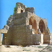
Source: http://www.iraqwho.com/Tourism_North_Historical.asp
Más sobre Qara Sarai Palace
457: al-Nabi Yonus Mosque
On one of the two most prominent mounds (the Al-Tawba mound) of Nineveh ruins, rises the Mosque of Prophet Younis "Biblical Jonah", the son of Amittai, from the 8th century B.C. The mosque was previously an Nestorian-Assyrian church. This location is believed to be the burial place of Jonah, and where King Esarhaddon had once built a palace.
This is a very, very famous mosque (arguably the most famous site in all of Mosul next to Nineveh itself) that many Muslims, Christians, and Assyrians visited and still visit today. A whale's tooth, appropriate to Jonah's well-known adventure at sea, is said to be preserved there. Apart from providing spiritual value to many, it also offers a stunningly beautiful view of Mosul from its top balcony. It's exterior lights provide a nice decorative flair to the uniquely designed mosque, particularly at night.

Source: Wikipedia
Más sobre al-Nabi Yonus Mosque
458: The Great (Nuriddin) Mosque [aka al-Nuri Mosque]
This was built by Nuriddin Zanki in 1172 A.D. and sits right next door to the Umayyad Mosque. Ibn Battuta found a marble fountain there and a mihrab with a Kufic inscription.
Note: It seems most sources agree that the minaret is, indeed, the only remains from the Umayyad Mosque from 640 and not part of this Nuriddin Mosque. But, strangely enough, some sources say that the minaret is part of the Nuriddin Mosque.
Here is an example of the confusion between sources (Quoted from http://www.arab.net/iraq/iq_mosul.htm) :
"The Great Nuriddine Mosque, built in 1172, has a famously crooked minaret standing 52 metres high. It is built of very elaborate brickwork and is named after its builder, Nuriddin Zanqi."
Definitive Answer:(see: http://archnet.org/library/sites/one-site.tcl?site_id=7739):
The minaret IS actually part of the al-Nuri mosque. This type of minaret construction and decoration with a square base is considered to be a typical feature of the later Abbasid minaret constructions, which provides pretty conclusive evidence that this wasn't a part of the early Umayyad mosque remains.
But this leaves open the question: Where are the remains of the Umayyad mosque, then? My best guess is that this minaret was, at one time, part of the original Umayyad mosque, and that al-Nuri's mosque simply built around it and incorporated it into the layout. The area was most likely rebuilt entirely during this mosque's construction, complete with the traditional Abbasid-style minaret.


Source:http://www.atlastours.net/iraq/mosul.html
Más sobre The Great (Nuriddin) Mosque [aka al-Nuri Mosque]
459: The Umayyad Mosque
The first mosque ever in the city, built in 640 A.D. by Utba bin Farqad Al-Salami after he conquered Mosul in the reign of Caliph Omar ibn Al-Khattab.
NOTE: This directly contradicts many other sources that I used in writing my paper that put Mosul's establishment (as a misr even) at 641 A.D. Looking at sources now, it seems the majority of them say that Utba bin Farqad Al-Salami conquered Mosul in 637 A.D. Regardless, it seems that this was certainly the first mosque in the region, and it must have been built soon after the misr had been established and the Kufans settled. The date of the building of this mosque seems appropriate: around 640/41 A.D.
The only part still extant is the remarkably elaborate brickwork 52 m high minaret that leans like the Tower of Pisa, called Al-Hadba (The Humped). The original mosque was most likely used primarily for Friday prayer services by the settled Kufans. SEE NOTE BELOW!
(Note: This seems to be incorrect information regarding the location of the remains of this mosque. Where the remains actually are is still up in the air, but I've found a definitive source that contradicts this assertion. Bottom line is that this humped minaret is NOT part of the Umayyad Mosque from 640 A.D. See the placemarker for al-Nuri Mosque).

Source: http://www.atlastours.net/iraq/mosul.html
Más sobre The Umayyad Mosque
460: Nabi Jirjis (Prophet George) Mosque
[Finding the right area for this was nearly impossible with the scant amount of information available to me. There were no pictures online at all. This represents my best guess at where the mosque and complex would most likely be. I've scoured every inch of every cemetary in Mosul, and this seems the most correct and likely of places. Measurements on the shrine itself reveal a perfect match to my source, so this is the mosque I'm looking for.]
This is the mosque commissioned by Timur to be built near the Nabi Jirjis shrine/complex. The shrine itself (marked in the middle of the cemetary) is a Timurid-style complex, dating to 1393, that remains very damaged.
This mosque, also built in 1393, should be recognizable from the outside for its high circular dome and minaret with a pointed top (in the Turkish style). It supposedly houses the minbar and the main mihrab that were transplanted from the Nabi Jirjis tomb chamber at the time of construction. In 1910, after a major earthquake, the Timurid dome collapsed and was re-built with stone following Mosul building techniques.
Source: http://archnet.org/library/sites/one-site.tcl?site_id=7828
Más sobre Nabi Jirjis (Prophet George) Mosque
461: Nabi Jirjis Complex/Shrine
This seems to be the Timurid complex, dating to 1393, that includes a small shrine dedicated to Nabi Jerjis (the saint/prophet George). (Indeed, this measures out to be 4.7 m x 4.7 m, exactly the measurements listed in my source, so this is IT! I've been looking hard for this!)
This tomb chamber is small, measuring 4.7 on each side and topped with a dome with ribs visible from the outside. The interior surfaces are severely damaged. Its walls are covered with green and yellow glazed brick tiles to the height of two meters and are surmounted by a Quranic inscription band.
Source: http://archnet.org/library/sites/one-site.tcl?site_id=7828
Más sobre Nabi Jirjis Complex/Shrine
462: Bash Tapia Castle
Part of Mosul's old walls which have all but disappeared, with the exception of these imposing ruins rising high over Tigris. These are the only remains of the original circuit walls built by MarwÄn sometime around 750 A.D.

Sources: http://www.atlastours.net/iraq/mosul.html (and my paper)
Más sobre Bash Tapia Castle
463: Mashhad of Imam Yahya ibn al-Qasim
Shrine for Mashhad of Imam Yahya ibn al-Qasim. Built in 1229 A.D. by Badr al-Din Lu'lu', then ruler of Mosul. The Mausoleum is located on the Tigris riverbank. The mihrab is situated at the southwest corner of the tomb because the building is not oriented towards Mecca.
Note: I wasn't able to find out any info about Imam Yahya ibn al-Qasim himself, just about the shrine.


Más sobre Mashhad of Imam Yahya ibn al-Qasim
464: Mosul Museum
From http://home.tiscali.dk/8x036176/atournor1.htm:
"The Museum is now in a new building, constructed after 1970, near Liberty Bridge. It has on diplay a large collection of finds that represent the successive civilizations of Iraq, from the Paleolithic Age up to later Arab Islamic times, with emphasis on archaeological finds discovered in Nineveh Governorate."
The museum was looted and ransacked on April 11, 2003 by the citizens of Mosul. This chaos in Mosul came a couple days before April 12, the official day that the Coalition troops "liberated" the city. Unfortunately, the troops were nowhere to be seen the days before and during the liberation, and this propelled Mosul into a frenzy of looting.
In less than 10 minutes, looters had walked off with several million dollars worth of Parthian sculpture. Various displays of ancient artifacts were broken as the looters made their escape.
Although American forces eventually set up defenses against further destruction and looting, this is just an example of unforeseen consequences of the occupation. The world is losing more than it had anticipated.

Source: http://arts.guardian.co.uk/news/story/0,11711,935267,00.html
Más sobre Mosul Museum
465: Church of Al-Tahira
Church of Al-Tahira "The Immaculate":Chaldean Catholic Church of Al-Tahira was built as a monastery in 300 A.D. and became a church in 1600, when various additions were built. Reconstructed last in 1743.
Note the shadow of the cross on the roof of the building. Cool!
Sources: http://www.globalheritagefund.org/where/nineveh.html
http://home.tiscali.dk/8x036176/atournor1.htm
Más sobre Church of Al-Tahira
466: Nineveh Gate/Walls
Just another photo of the walls and gates surrounding the ancient Nineveh site:
Más sobre Nineveh Gate/Walls
467: Reconstructed City Walls
Major portions of the city walls and gates were reconstructed using material found around the collapsed walls themselves. This adds to their authenticity and historical testimony. The walls and gates around the ruins are in various stages of preservation, and some gates (there were 15 in the Assyrian period) have been entirely restored.

Source: http://www.globalheritagefund.org/where/nineveh.html
Más sobre Reconstructed City Walls
468: Nineveh Ruins
The Ruins of Nineveh:
Nineveh is a contained archaeological site. The significance of the site of Nineveh is seen through the role that it has played historically as a key capital city of the Assyrian Empire. The long sequence of occupation at the site attests to its importance throughout antiquity. Furthermore, the previous exploration at the site has revealed incredibly important information, specifically texts, seals, prisms and other texts in libraries and caches attesting in vast ways to the language, economy, religion, and culture of the time period. Secondly, although half of the site is obscured by modern construction, the other half is untouched and its potential preservation may yield a vast amount of archaeological information.
Nineveh has long been a favored tourist destination, with visible walls and gates, as well as the throne room of Sennacherib's palace, which was roofed in the 1970s. (See separate placemark for more info on this)
Note: This has been partially copied from http://www.globalheritagefund.org/where/nineveh.html
Más sobre Nineveh Ruins

470: Sennacherib Palace Site
One of only two preserved Assyrian palaces in the world. This palace and throne-room suite was built for Sennacherib, who ruled Nineveh around 700 B.C. This particular structure survived Nineveh's sacking in 612 B.C. as well as more recent vandalism in the early 1990s. The Iraqi government roofed the site in the 1970s and protected it as the "Sennacheribe Palace Site Museum", where tourists and visitors could view the many slabs and structures of Biblical and historical importance.
Sources:
http://www.archaeology.org/online/features/nineveh/
http://www.crystalinks.com/nineveh.html
http://www.globalheritagefund.org/where/nineveh.html
Más sobre Sennacherib Palace Site
471: Dayr Mar Mikhail Monastary
Assyrian monastery with interesting history. It was established in the mid-fourth century A.D. by Mar Mikhael.
Several remaining manuscripts and evidence show that the monastery remained an active school of thought and spiritual source until its whole or partial destruction by Nader-Shah in 1743 A.D.
Inscriptions on the East walls of the monastery today show that it was re-built, or renovated, in 1867, under the care of Father Romanos Al-alqushy. It was further renovated in 1956 under the guidance of Father Afram Rassam.
Source:http://www.aina.org/aol/syriac.htm
Más sobre Dayr Mar Mikhail Monastary
472: Saddam's Palace/FOP Freedom
This compound was a summer retreat for Saddam. He spent several months here prior to the invasion planning his and the military's next move. The compound was captured by US-led special forces with little resistence.
During Operation Iraqi Freedom this was the Home of the 101st Airborne Division's main command post called "FOP Freedom".

Más sobre Saddam's Palace/FOP Freedom
473: Sawas Monument
There is no information on what this says, represents, or looks like anywhere that I could find. Too bad, looks interesting.
Más sobre Sawas Monument
474: Al-Rahman Mosque (Grand Mosque)
Originally modeled after the "Grand Saddam Mosque" under construction in Baghdad (now called the Al-Rahman [The Merciful] Mosque). Saddam went on a Mosque building spree after the Gulf War. He wanted a grand mosque named after him in every one of the provinces. The Grand Mosque in Baghdad was, at the time of its construction, to be the biggest mosque in the world.
This is, presumably, modeled similarly to Baghdad's Grand Mosque and served the same service of positive propaganda for Saddam. It is the biggest mosque in Mosul. Still under construction. (Who knows when/if it'll ever get done...I think a new contractor has taken the project back up under the "al-Rahman" designation).

Source: http://phlebotomus.blogspot.com/2004_11_01_phlebotomus_archive.html
Más sobre Al-Rahman Mosque (Grand Mosque)
475: The Roman Catholic Church
Built by the Dominican Fathers in Nineveh street in 1893.
Source: http://home.tiscali.dk/8x036176/atournor1.htm
Más sobre The Roman Catholic Church
485: Camp Marez [FOB Glory / Fire Base Glory]
US Army Forward Operating Base Marez (formerly known as FOB Glory / Fire Base Glory)
In early 2004 FOB Glory / Fire Base Glory was renamed Camp Marez.
Home to the 101st Airborne Division rear command post and various other units.
Source: http://www.globalsecurity.org/military/world/iraq/mosul-airbase.htm
Más sobre Camp Marez [FOB Glory / Fire Base Glory]
486: Saddam's Palace/FOP Freedom
This compound was a summer retreat for Saddam. He spent several months here prior to the invasion planning his and the military's next move. The compound was captured by US-led special forces with little resistence.
During Operation Iraqi Freedom this was the Home of the 101st Airborne Division's main command post called "FOP Freedom".
Más sobre Saddam's Palace/FOP Freedom