Lugares de interés (POIs) del Mapa
2: Untitled
LOCATION #1: 0123 UTC
9 m waves (possible 20m ?)
12m Water height measurement/observation
Second wave arrived at 0153 UTC, and the most powerful Third wave arrived at 0215 UTC
0842 local time. Coastline buildings were swept away.
Debris carried up to 4km inland. Approximately 70,000 deaths from this area alone.
Note: The satellite image for this area appears to have been taken soon after the tsunami.

Photo courtesy of the U.S. Geological Survey
.Más sobre Untitled
3: Untitled

Aerial and Satellite images courtesy of GlobeXplorer and DigitalGlobe. Retrieved from http://www.nzaid.govt.nz
Más sobre Untitled
4: Untitled
Wave heights 25 m
35.7m Water height measurement/observation
The satellite image appears to have been taken soon after the tsunami.

U.S. Navy photo by Photographer's Mate 3rd Class Jacob J. Kirk
Más sobre Untitled
5: Untitled
90m coal barge with tugboat attached washed 160m inland.
34m Water height measurement/observation
.Más sobre Untitled
7: Untitled
50m Water height measurement/ observation is the highest recorded for this tsunami.

U.S. Navy photo by Photographer's Mate 3rd Class Tyler J. Clements
Más sobre Untitled
8: Untitled
| 21m Water height measurement/observation Complete obliteration of this town. Less than 1,000 survivors out of an estimated population of 10,000. The satellite image appears to have been taken soon after the tsunami. |  |
Más sobre Untitled
9: Untitled
| 15m Water height measurement/observation Water reached 5km inland. Indonesia's Death Toll: |  |
Más sobre Untitled
10: Untitled
LOCATION #2: 0300 UTC
5-10 m waves
5.4m Water height measurement/observation
This is one of the popular tourist locations that was hit by the tsunami waves. It is estimated that 9,000 tourists perished in the tsunami at locations like this. Phuket Island was at high tide when the tsunami hit.

AP Photo/Karim Khamzin. Retrieved from http://drakulits.blogspot.com/2004_12_01_archive.html
Más sobre Untitled
11: Untitled
| 0300 UTC 2 hours after the earthquake, an orbiting satellite measures a tsunami height of 60cm in the open ocean. Tsunami waves aren't easily detected in the open ocean without intruments. The wave shape depends on the bathymetry(depths) of the ocean bottom. Thus in the open ocean, the wave may only seem to be a slight bump. The wavelength (crest to crest) however, can be as much as 100miles long. |  |
Más sobre Untitled
12: Untitled
LOCATION #3: 0310 UTC
10m wave reported
7m Water height measurement/observation

Photo courtesy of U.S. Geological Service. Photo credit:Phillip Liu, Cornell University
Más sobre Untitled
13: Untitled
LOCATION #4: 0316 UTC
0.21m Tide gauge measurement
This is one of many locations across the Indian Ocean that has instruments that records ocean data.
GFDL Image by David.Monniaux. Retrieved from http://en.wikipedia.org/wiki/Tide_gauge
Más sobre Untitled
14: Untitled
LOCATION #5: 0322 UTC
Sri Lanka's Death Toll:
30,900 dead/ 5,400 missing

Photo courtesy of NGDC. Photo Provided By: Chris Chapman, Schlumberger Cambridge Research, Cambridge, U.K
Más sobre Untitled
15: Untitled
LOCATION #6: 0325 UTC
11.6m wave
10m Water height measurement/observation
Another popular tourist location with dozens of hotels and ocean front bungalows. Eyewitnesses report the ocean receded for 20 minutes prior to the tsunami. Many did not realize that this was a signal of what to come. Many foreign tourists were on the beach as the waves hit midmorning.
3950 deaths at this location.

Photo credit: John and Jackie Knill. Retrieved from http://www.andaman.org/BOOK/denis_pics/denis.htm
Más sobre Untitled
16: Untitled
LOCATION #7: 0334 UTC
6.5m Water height measurement/observation
120 deaths

Retrieved from http://mutiny.in/author/angel/page/2/
Más sobre Untitled
17: Untitled
0334 UTC
9.6m Water height measurement/observation
200 deaths

Photo courtesy of NGDC. Image Credit: Joseph Trainor,University of Delaware, Disaster Relief Center
Más sobre Untitled
18: Untitled
| 0335 UTC 5.8 m Water height measurement/observation 6000 people perished at Nagapattinum making it one of the hardest hit in India. India's Death Toll: |  |
Más sobre Untitled
19: Untitled
0345 UTC
13m Water height measurement/observation
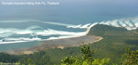
Photo courtesy of NOAA. Photo credit: Andrew Grawin
Más sobre Untitled
20: Untitled
0336 UTC
10.9m Water height measurement/observation
Western coastlines of India and Sri Lanka were not spared from the tsunami. At this location a 9-car train was engulfed by waves and 1,500 passengers perished.

Photo courtesy of Shahidul Alam / DRIK. Retrieved from http://www.andaman.org/BOOK/denis_pics/denis.htm
Más sobre Untitled
21: Untitled
0400 UTC
19.57 Water height measurement/ observation
Thailand's Death Toll:
5,300 dead/ 3,100 missing

Photo courtesy of HoboTraveler.com. Retrieved from http://www.hobotraveler.com/169kohphiphithailandtsunami_02.shtml
Más sobre Untitled
22: Untitled
LOCATION #8: 0406 UTC
1-4m waves
3m Water height measurement/observation
Some islands were completely submerged as the ocean rushed across them.
2000 homes destroyed
Maldive's Death Toll:
82 dead/ 26 missing

Retrieved from http://clin.lsi.uniovi.es/wod/
Más sobre Untitled
23: Untitled
0415 UTC
3hours and 15minutes after the earthquake, an orbiting satellite measures a tsunami height of 40cm in the open ocean.

Image courtesy of NOAA
Más sobre Untitled

25: Untitled
0430 UTC
2.9 Water height measurement/observation.
Myanmar's Death Toll:
90 dead/ 10 missing

Photo courtesy of UNICEF. Retrieved from http://fieldnotes.unicefusa.org/mt/mt-search.cgi?tag=UNICEF&blog_id=1.
Más sobre Untitled
26: Untitled
LOCATION #9: 0500 UTC
2m Water height measurement/observation
130 huts were washed away and 17 deaths were recorded at this location.
Despite its proximity to the area that generated the tsunami, Myanmar did not experience the waves until after India and Sri Lanka. This is partly due to the bathymetry, or shape, of the ocean bottom. It is also due to its northerly location; the wave energy was directed east and westward. Had the tsunami been directed toward Myanmar's low delta coastline, the country's death toll would have been far greater as it was with the tropical cyclone of 2008.

Photo courtesy of United Nations Development Programme. Retrieved from http://www.undp.org/cpr/disred/english/news/archives/2005/August.htm.
Más sobre Untitled
27: Untitled
LOCATION #10: 0500 UTC
3m waves
Malaysia's Death Toll:
68 dead/ 6 missing

Photo credit: Eric Skitzi. Retrieved from http://www.newsday.com/news/nationworld/ny-woquak1229,0,7192932.story
Más sobre Untitled
28: Untitled
LOCATION #11: 0639 UTC
Tide gauge detected tsunami.
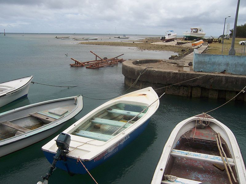
GFDL Image by B.navez. Retrieved from http://en.wikipedia.org/wiki/Rodrigues_Island
Más sobre Untitled
31: Untitled
LOCATION #14: 0800 UTC
9.5M Water height measurement/observation
The waves struck low lying fishing villages. Like other locations around the Indian Ocean, these villages were crowded and located very close to the shore. The tsunami took place at the peak of the fishing season in Somalia.
289 deaths recorded
.

Photo courtesy of World Health Organization: http://www.who.int
Más sobre Untitled
35: Untitled
LOCATION #18: 1339 UTC
0.87m Tide gauge measurement

Image retrieved from http://ivs.nict.go.jp/mirror/publications/ar1999/nssyow/
Más sobre Untitled
36: Credits
The Indian Ocean Tsunami of 2004 has been studied by a large number of countries and scientific organizations. The chronology and statistics of this event can vary and includes numerous approximations. An exhaustive attempt was taken by the author to be as accurate as possible.
Information courtesy of:
BBC webpage on the event.
http://news.bbc.co.uk/2/hi/in_depth/4136289.stm
Japanese Research Team from Kyoto University
http://www.tsunami.civil.tohoku.ac.jp/sumatra2004/report.html
National Geophysical Data Center (NGDC)
http://www.ngdc.noaa.gov/hazard/tsu.shtml
http://www.ngdc.noaa.gov/hazard/hazards.shtml
NOAA / PMEL / Center for Tsunami Research.
http://nctr.pmel.noaa.gov/
Spiritus Temporis.com History Web Ring
http://www.spiritus-temporis.com/2004-indian-ocean-earthquake
U.S. Geological Survey (USGS)
http://walrus.wr.usgs.gov/tsunami/
Wikipedia
http://en.wikipedia.org/wiki/Indian_Ocean_Tsunami
.
Más sobre Credits
37: Links to Images
Image links
Tsunami Model animation:
http://nctr.pmel.noaa.gov/Mov/TITOV-INDO2004.mov
Global Model animation:
http://nctr.pmel.noaa.gov/Mov/indo_gl2.mov
Before and After Photos
http://homepage.mac.com/demark/tsunami/11.html
Videos
http://asiantsunamivideos.com/
.
Más sobre Links to Images
38: Earthquake Epicenter
9.2 magnitude quake at 0058 UTC triggers a chain reaction 15m fault slip for 994 miles
Más sobre Earthquake Epicenter