Lugares de interés (POIs) del Mapa
0: Tenino Meeker Marker
 | |
Meeker Marker - Tenino, Washington2/21/1906 | |
 | |
| It is located on the main road through town (Old Highway 99), also called Sussex Ave. E. at the corner of Sheridan St. N. | |
Learn More | |
| OCTA | NPS |
$[geDirections] | |
| ©2010 Ron Hall | |
Más sobre Tenino Meeker Marker
1: Dalles Meeker Marker
| | |
Meeker Marker - Dalles3/12/1906 | |
 | |
| It is located in a city park at 6th and Union Streets | |
Learn More | |
| OCTA | NPS |
$[geDirections] | |
| ©2010 Ron Hall | |
Más sobre Dalles Meeker Marker
2: Pendleton Meeker Marker
| | |
Meeker Marker - Pendleton3/31/1906 | |
 | |
| It is located at the entrance to the Eastern Oregon Correctional Institution. This is on the west side of the town on U.S. Highway 30. It sits to the right of the Correctional Institution sign at the main entrance. | |
Learn More | |
| OCTA | NPS |
$[geDirections] | |
| ©2010 Ron Hall | |
Más sobre Pendleton Meeker Marker
3: Meachem Meeker Marker
| | |
Meeker Marker - Meachem4/6/1906 | |
 | |
| It is located at the entrance to Emigrant Springs State Park. It sits to the left of the entrance in a little hollow about 20 feet off the road, by a little seep that is all that is left of the original springs, | |
Learn More | |
| OCTA | NPS |
$[geDirections] | |
| ©2010 Ron Hall | |
Más sobre Meachem Meeker Marker
4: Lagrande Meeker Marker
| | |
Meeker Marker - Lagrande4/10/1906 | |
 | |
| It is located on the corner of B and Walnut Streets, in the front yard of the private residence there. | |
Learn More | |
| OCTA | NPS |
$[geDirections] | |
| ©2010 Ron Hall | |
Más sobre Lagrande Meeker Marker
5: Lower Ladd's Canyon Meeker Marker
| | |
Meeker Marker - Lower Ladd's Canyon4/11/1906 | |
 | |
| Missing today It was located about .25 miles east of Pierce Road on Hot Lake Lane. Look for a pile of rocks in some brush on the north side of the road. It stood there. | |
Learn More | |
| OCTA | NPS |
$[geDirections] | |
| ©2010 Ron Hall | |
Más sobre Lower Ladd's Canyon Meeker Marker
6: Baker City Meeker Marker
| | |
Meeker Marker - Baker City4/19/1906 | |
 | |
| It is located in the city park across the street from the Oregon Trail Regional Museum. | |
Learn More | |
| OCTA | NPS |
$[geDirections] | |
| ©2010 Ron Hall | |
Más sobre Baker City Meeker Marker
7: Flagstaff Hill Meeker Marker
| | |
Meeker Marker - Flaggstaff Hill4/19/1906 | |
 | |
| It is located on the grounds of the Oregon Trail Interpretive Center. From the Center a trail leads down the hill to the marker. A covered wagon exhibit is nearby. | |
Learn More | |
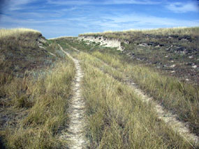
| OCTA | NPS |
$[geDirections] | |
| ©2010 Ron Hall | |
Más sobre Flagstaff Hill Meeker Marker
8: Straw Creek Ranch Meeker Marker
| | |
Meeker Marker - Strew Creek Ranch4/21/1906 | |
 | |
| Going eastbound on I-84 take the Mt. Pleasant exit and follow Old Highway 30 several miles until it crosses under the freeway to the west side. Old Highway 30 now parallels I-84. Look for a tunnel going east under I-84 providing access to the privately owned Straw Creek Ranch. Go through the tunnel. This is a county road. The marker is in front of the farm house. | |
Learn More | |
| OCTA | NPS |
$[geDirections] | |
| ©2010 Ron Hall | |
Más sobre Straw Creek Ranch Meeker Marker
9: Jett Farm Meeker Marker
| | |
Meeker Marker - Jett Farm4/25/1906 | |
 | |
| Missing today Take exit 340 eastbound off I-84 in Lime, Oregon. Follow the unpaved county road that parallels the Burnt River going north to the private farm at the end of the road. Somewhere along this gravel road Ezra set the marker. | |
Learn More | |
| OCTA | NPS |
$[geDirections] | |
| ©2010 Ron Hall | |
Más sobre Jett Farm Meeker Marker
10: Huntington Meeker Marker
| | |
Meeker Marker - Huntington4/26/1906 | |
 | |
| It is located in a tiny city park at the corner of 3rd St. W. and W. Washington. Need to be on Washington Street to find - back side of park. | |
Learn More | |
| OCTA | NPS |
$[geDirections] | |
| ©2010 Ron Hall | |
Más sobre Huntington Meeker Marker
11: Vale Meeker Marker
| | |
Meeker Marker - Vale4/30/1906 | |
 | |
| It is located in front of the County Courthouse in Vale. | |
Learn More | |
| OCTA | NPS |
$[geDirections] | |
| ©2010 Ron Hall | |
Más sobre Vale Meeker Marker
12: Boise Meeker Marker
| | |
Meeker Marker - Boise5/9/1906 | |
 | |
| It is located on the State Capitol grounds. The shaft is 10-12 feet tall. | |
Learn More | |
| OCTA | NPS |
$[geDirections] | |
| ©2010 Ron Hall | |
Más sobre Boise Meeker Marker
13: South Pass Meeker Marker
| | |
Meeker Marker - South Pass6/24/1906 | |
 | |
| On Highway 28 find the rest area by the Sweetwater Bridge. Go south up the hill .7 miles and turn left onto Oregon Buttes Road. Drive about 3 miles to an intersection with a rutted dirt road. This is the Oregon Trail. Go about 1 mile on the rutted road to the marker. | |
Learn More | |
| OCTA | NPS |
$[geDirections] | |
| ©2010 Ron Hall | |
Más sobre South Pass Meeker Marker
14: Independence Rock
| | |
Independence Rock7/3/1906 | |
 | |
| It is a marker in its own right. Ezra chiseled his logo on it on July 3, 1906. There is an interpretive panel directly in front of the chiseled inscription. | |
Learn More | |
| OCTA | NPS |
$[geDirections] | |
| ©2010 Ron Hall | |
Más sobre Independence Rock
15: Upper Ladd’s Canyon - Ordered Marker
| | |
Ordered Meeker Marker - Upper Ladd's Canyon4/12/1906 | |
 | |
| Missing today About 5 miles up the freeway toward Baker City from the rest area at the I-84 and Foothill Road intersection at the mouth of the canyon look for a frontage road on your right. The marker was placed where the freeway makes a bend by the frontage road. | |
Learn More | |
| OCTA | NPS |
$[geDirections] | |
| ©2010 Ron Hall | |
Más sobre Upper Ladd’s Canyon - Ordered Marker
16: Durkee - Ordered Marker
| | |
Ordered Meeker Marker - Durkee5/1/1906 | |
 | |
| It is located on old Highway 30 in Durkee next to a power pole a short way west of the old school. There are plans to move it to the school yard to the south. | |
Learn More | |
| OCTA | NPS |
$[geDirections] | |
| ©2010 Ron Hall | |
Más sobre Durkee - Ordered Marker
17: South Boise - Ordered Marker
| | |
Ordered Marker - South Boise5/9/1906 | |
 | |
| It is located on the corner of Broadway and Boise Avenues. There is a small mini-park on the NW corner of the intersection diagonally across from the school. | |
Learn More | |
| OCTA | NPS |
$[geDirections] | |
| ©2010 Ron Hall | |
Más sobre South Boise - Ordered Marker
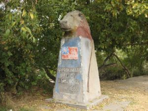
18: Old Ft Boise - Ordered Marker
| | |
Ordered Marker - Old Fort Boise7/17/1906 | |
 | |
| Follow Highway 201 five miles south of the town of Nyssa, Oregon. An interpretive kiosk describes the Snake River Crossing. The stone stands by the kiosk. | |
Learn More | |
| OCTA | NPS |
$[geDirections] | |
| ©2010 Ron Hall | |
Más sobre Old Ft Boise - Ordered Marker
19: Twin Falls - Ordered Marker
| | |
Ordered Marker - Twin FAlls7/17/1906 | |
 | |
| erected in 1910) It stands at the entrance to Rock Creek Park which is about a mile west of downtown Twin Falls off U.S. Highway 30/93, West Addison Ave. | |
Learn More | |
| OCTA | NPS |
$[geDirections] | |
| ©2010 Ron Hall | |
Más sobre Twin Falls - Ordered Marker
20: Cokeville - Ordered Marker
| | |
Ordered Marker - Cokeville1906 | |
 | |
| It is located on the southeast corner of U.S. Highway 30 and State Route 232 in Cokeville. | |
Learn More | |
| OCTA | NPS |
$[geDirections] | |
| ©2010 Ron Hall | |
Más sobre Cokeville - Ordered Marker
21: Parma - Trip Related
| | |
Trip Related Marker - ParmaMay 5, 1906 | |
 | |
| Probably replaced with current stone at a later time. It is located on the grounds of the replica of Old Fort Boise in Parma. This is on U.S. Highway 26/30 just east of town. | |
Learn More | |
| OCTA | NPS |
$[geDirections] | |
| ©2010 Ron Hall | |
Más sobre Parma - Trip Related
22: Pocatello - Trip Related
| | |
Trip Related Marker - PocotellaJune 1907 | |
 | |
| It is located inside the gate of the Fort Hall Replica in Pocatello. | |
Learn More | |
| OCTA | NPS |
$[geDirections] | |
| ©2010 Ron Hall | |
Más sobre Pocatello - Trip Related
23: Fort Hall - Trip Related
| | |
Trip Related - Fort HallJune 1907) | |
 | |
| Visitors must make arrangements with the Fort Hall Reservation Tribal Council to visit the site. It is closed to the general public. | |
Learn More | |
| OCTA | NPS |
$[geDirections] | |
| ©2010 Ron Hall | |
Más sobre Fort Hall - Trip Related
24: Montpelier - Trip Related
| | |
Trip Related - Montpelier7/24/1907 | |
 | |
| It is located at the front entrance of the National Oregon/California Trail Center. | |
Learn More | |
| OCTA | NPS |
$[geDirections] | |
| ©2010 Ron Hall | |
Más sobre Montpelier - Trip Related
25: Casper - Trip Related
| | |
Trip Related - CasperFebruary 1911 | |
 | |
| It is located on the east side of North Center Street just south of East B Street. It is across the street from the Casper City and County Building. | |
Learn More | |
| OCTA | NPS |
$[geDirections] | |
| ©2010 Ron Hall | |
Más sobre Casper - Trip Related
26: American Falls - Trip Rekated
| | |
TripRelated - American Falls1915 | |
 | |
| It is located on the corner of Falls Avenue and Bridge Street, sitting in a desolate gravel lot overlooking the dam and the Snake River. | |
Learn More | |
| OCTA | NPS |
$[geDirections] | |
| ©2010 Ron Hall | |
Más sobre American Falls - Trip Rekated
27: Kearney, Nebraska -Cememorative
| | |
Commemorative - Kearney, Nebraska2/14/1910 | |
 | |
| DAR It is at the intersection of Central Avenue and North Railroad Street. | |
Learn More | |
| OCTA | NPS |
$[geDirections] | |
| ©2010 Ron Hall | |
Más sobre Kearney, Nebraska -Cememorative
28: Gothenberg, Nebraska - Commemorative
| | |
Commemorative - Gothenberg, Nebraska1912) | |
 | |
| State of Nebraska To find it drive south from town on State Highway 47. Cross the Platte River and continue south about 1 mile from the river. The marker is located on the west side of the road about 100 yards north of Road 763 & the 96 Ranches sign. | |
Learn More | |
| OCTA | NPS |
$[geDirections] | |
| ©2010 Ron Hall | |
Más sobre Gothenberg, Nebraska - Commemorative
29: Douglas, Wyoming
| | |
Commemorative - Douglas, Wyoming9/20/1913 | |
 | |
| State of Wyoming and Citizens of Converse County It is located south of Douglas on the south side of State Route 91, 3.8 miles south of State Route 96 | |
Learn More | |
| OCTA | NPS |
$[geDirections] | |
| ©2010 Ron Hall | |
Más sobre Douglas, Wyoming
30: Glen Rock, Wyoming - #1
| | |
Commemorative - Glenrock, WY1913 | |
 | |
| located near milepost 171 on the old “Glenrock Highway” (U.S. 26). This is 4.7 miles from the west edge of Glenrock or 2.7 miles west of the Ringo-Parker grave site. Turn north on a gravel road. In 0.1 mile, turn west. The marker is about 100 yards down this road. It is next to the grave of the child, Ada McGill, and a pony express marker. It is a reddish colored stone about 3 feet tall. The grave is enclosed by a fence. The Oregon Trail is about fifty feet south of this spot. | |
Learn More | |
| OCTA | NPS |
$[geDirections] | |
| ©2010 Ron Hall | |
Más sobre Glen Rock, Wyoming - #1
31: Glenrock, WY #2
| | |
Commemorative - Glenrock, WY1913 | |
 | |
| located south of the Dave Johnson Power Plant at a small turnout near the A.H. Unthank grave marker just east of Glenrock on a spur road off of U.S. Highway 26 near the power plant. | |
Learn More | |
| OCTA | NPS |
$[geDirections] | |
| ©2010 Ron Hall | |
Más sobre Glenrock, WY #2
32: Glenrock, Wy - #3
| | |
Commemorative - Glenrock, WY1913 | |
 | |
| on the east side of State Route 94 (Esterbrook Road) about 10 miles south of Riverbend Road Streetview | |
Learn More | |
| OCTA | NPS |
$[geDirections] | |
| ©2010 Ron Hall | |
Más sobre Glenrock, Wy - #3
33: Glenrock, WY #4
| | |
Commemorative - Glenrock, WY1913 | |
 | |
| Approximated by RHall - The fourth marker is about 10.6 miles south of Riverbend Drive on State Route 94 (Esterbrook Road). Turn east and follow a dirt road 1.9 miles until reaching old LaBonte Stage Station and stream crossing. The marker is 6 miles further. The marker is on private land. Permission is required to visit. | |
Learn More | |
| OCTA | NPS |
$[geDirections] | |
| ©2010 Ron Hall | |
Más sobre Glenrock, WY #4
34: Glenrock, WY #5
| | |
Commemorative - Glenrock, WY1913 | |
 | |
| The fifth marker is between Glenrock and Douglas on the east side of the Natural Bridge Road 2.6 miles south of I-25. This is where the Oregon Trail crosses the Natural Bridge Road. Streetview | |
Learn More | |
| OCTA | NPS |
$[geDirections] | |
| ©2010 Ron Hall | |
Más sobre Glenrock, WY #5
35: North Platte, Nebraska
| | |
Commemorative - North Platte, Neb.1914 | |
 | |
| located south of North Platte. At the I-80 and Highway 83 intersection, head about 1 mile south to State Farm Road. Take a right turn, go one block, and the marker is in the southwest corner of the W. State Farm Road and S. Willow Street intersection. Streetview | |
Learn More | |
| OCTA | NPS |
$[geDirections] | |
| ©2010 Ron Hall | |
Más sobre North Platte, Nebraska
36: Omaha, Nebraska #1
| | |
Commemorative - Omaha, Nebraska #11914 | |
 | |
| Located in Riverside park is a stone monument marking the beginning of the “California” Trail. | |
Learn More | |
| OCTA | NPS |
$[geDirections] | |
| ©2010 Ron Hall | |
Más sobre Omaha, Nebraska #1
37: Omaha, Nebraska #2
| | |
Commemorative - Omaha, Nebraska #21914 | |
 | |
| A DAR “California” Trail monument is located in Bemis Park. | |
Learn More | |
| OCTA | NPS |
$[geDirections] | |
| ©2010 Ron Hall | |
Más sobre Omaha, Nebraska #2
38: Tumwater, Washington
| | |
Commemorative - Tumwater, Washington8/15/1916 | |
 | |
| DAR/SAR It is located on the corner of Boston St. SW and Deschutes Way SW, at the west end of the Deschutes River Bridge about 200 feet from the Tumwater Falls Park Streetview | |
Learn More | |
| OCTA | NPS |
$[geDirections] | |
| ©2010 Ron Hall | |
Más sobre Tumwater, Washington
39: Bush Prairie, Washington
| | |
Commemorative - Bush Prairie, Washington9/6/1916 | |
 | |
| It is located at 8820 Capitol Blvd. (Old Highway 99), east of the Olympia Municipal Airport, on the east side of the road near the intersection with 88th Ave. SE. Streetview | |
Learn More | |
| OCTA | NPS |
$[geDirections] | |
| ©2010 Ron Hall | |
Más sobre Bush Prairie, Washington
40: Centralia, WA
| | |
Commemorative - Centralia, WA10/12/1916 | |
 | |
| DAR/SAR It is located in Fort Borst Park in front of the Joseph Borst family home. | |
Learn More | |
| OCTA | NPS |
$[geDirections] | |
| ©2010 Ron Hall | |
Más sobre Centralia, WA
41: Grand Mound, Washington
| | |
Commemorative - Grand Mound, Washington10/12/1916 | |
 | |
| DAR/SAR It is located on the corner of Highway 2 and Grand Mound Way. It is on the west side of the road in a small landscaped area next to the Suburban Propane store. Streetview | |
Learn More | |
| OCTA | NPS |
$[geDirections] | |
| ©2010 Ron Hall | |
Más sobre Grand Mound, Washington
42: Jackson’s Prairie, Washington
| | |
Commemorative - Jackson’s Prairie, Washington10/21/1916 | |
 | |
| DAR/SAR It is located in front of the Matilda N. Jackson State Park. This is just north of the historic 1847 Jackson Courthouse and home. It is on the west side of the Jackson Highway (Old 99), 1/8 mile north of U.S. Highway 12. Streetview | |
Learn More | |
| OCTA | NPS |
$[geDirections] | |
| ©2010 Ron Hall | |
Más sobre Jackson’s Prairie, Washington
43: Toledo, Washington
| | |
Commemorative - Toledo, Washington10/21/1916 | |
 | |
| DAR/SAR It is located on the corner of N. Fifth and St. Helens and the Jackson Highway (Old 99). It is just before the “Welcome to Toledo” sign. It is on a little grass island where all three streets merge. Streetview | |
Learn More | |
| OCTA | NPS |
$[geDirections] | |
| ©2010 Ron Hall | |
Más sobre Toledo, Washington
44: Grand Island, Nebraska #1
| | |
Commemorative - Grand Island, Nebraska #17/4/1924 | |
 | |
| Hall County Historical Society, At the Platte Valley Academy campus at the extreme west edge of Hall County at 19338 W. Campus Drive Shelton, Nebraska. The academy is just east of Shelton off U.S. 30. Drive into the campus and it is at the corner of PVA Drive and West Campus Drive. Next to it is a sign that reads, “1923 Stone Trail Marker Wood River Valley Historical Society.” | |
Learn More | |
| OCTA | NPS |
$[geDirections] | |
| ©2010 Ron Hall | |
Más sobre Grand Island, Nebraska #1
45: Wood River, Nebraska
| | |
Commemorative - Wood River, Nebraska7/4/1924 | |
 | |
| On the west side of Highway 11 just north of the Wood River city limits. It is just before the school at the corner of Greenstreet Road and Highway 11. Highway 11 goes both north and south of Highway 30 at Wood River. Take the route that goes north. Next to it is a sign that reads, “1923 Stone Trail Marker Wood River Valley Historical Society.” | |
Learn More | |
| OCTA | NPS |
$[geDirections] | |
| ©2010 Ron Hall | |
Más sobre Wood River, Nebraska
46: Ada, Nebraska
| | |
Commemorative - Ada, Nebraska7/4/1924 | |
 | |
| On the west side of Alda Road, 1 mile south of Alda--ruts may be seen behind the sign. Streetview | |
Learn More | |
| OCTA | NPS |
$[geDirections] | |
| ©2010 Ron Hall | |
Más sobre Ada, Nebraska
47: Stuhr Museum, Grand Island NB
| | |
Commemorative - Stuhr Museum, Grand Island NB7/4/1924 | |
 | |
| At the Stuhr Museum east of Fonner Pavilion. Take exit 312 off I-80. Go 4 miles north to the intersection of Highway 281 & Highway 34. The marker is near the Indian earth lodge exhibit and the tee pee. | |
Learn More | |
| OCTA | NPS |
$[geDirections] | |
| ©2010 Ron Hall | |
Más sobre Stuhr Museum, Grand Island NB
48: Grand Island, Nebraska
| | |
Commemorative - Grand Island, Nebraska7/4/1924 | |
 | |
| At the corner of Riverside Drive and Stagecoach Road in a residential neighborhood north of Riverside Golf Course Streetview | |
Learn More | |
| OCTA | NPS |
$[geDirections] | |
| ©2010 Ron Hall | |
Más sobre Grand Island, Nebraska
49: Grand Island, Neb
| | |
Commemorative - Grand Island, Neb7/4/1924 | |
 | |
| At the corner of Seedling Mile Road and Gunbarrel Road Streetview | |
Learn More | |
| OCTA | NPS |
$[geDirections] | |
| ©2010 Ron Hall | |
Más sobre Grand Island, Neb
50: Chehalis, WA
| | |
Commemorative - Chehalis, WA | |
 | |
| located on Market Street, at the foot of the hill below City Hall, the site Ezra originally suggested Streetview | |
Learn More | |
| OCTA | NPS |
$[geDirections] | |
| ©2010 Ron Hall | |
Más sobre Chehalis, WA
51: Claquato, WA
| | |
Commemorative - Claquato, WA | |
 | |
| located in front of the Claquato Church. | |
Learn More | |
| OCTA | NPS |
$[geDirections] | |
| ©2010 Ron Hall | |
Más sobre Claquato, WA
52: Soda Springs, Idaho
| | |
Commemorative - Soda Springs, Idaho | |
 | |
| Located on north side of Main Street/Rt 30 - center of town on the edge of the park. Streetview | |
Learn More | |
| OCTA | NPS |
$[geDirections] | |
| ©2010 Ron Hall | |
Más sobre Soda Springs, Idaho
53: Oregon Trail Interpretive Center
| | |
Oregon Trail Interpretive Center | |
 | |
| The Center offers living history demonstrations, interpretive programs, exhibits, multi-media presentations, special events, and more than four miles of interpretive trails. | |
Ezra Meeker's Story | |
| Website | OCTA |
$[geDirections] | |
| ©2010 Ron Hall | |
Más sobre Oregon Trail Interpretive Center
54: End of the Trail Interpretive Center
| | |
End of the Trail Interpretive Center | |
 | |
| The Visitor Center also features changing displays on Oregon's heritage and local artifacts. The End of the Oregon Trail grounds are open for self-guided tours outside and is a great place for a family picnic. | |
Ezra Meeker's Story | |
| Website | OCTA |
$[geDirections] | |
| ©2010 Ron Hall | |
Más sobre End of the Trail Interpretive Center
55: National Oregon/California Trail Center
| | |
National Oregon/California Trail Center | |
 | |
| The Trail Center was built to preserve, perpetuate and promote the pioneer history and heritage of the Oregon/California Trail and the Bear Lake Valley. The interpretation of this epoch migration is told using live actors within historically accurate interpretive areas located in the center. Vistitors join a simulated wagon train headed west and experience what it was like to prepare for the journey. | |
Ezra Meeker's Story | |
| Website | OCTA |
$[geDirections] | |
| ©2010 Ron Hall | |
Más sobre National Oregon/California Trail Center
56: National Frontier Trails Museum
| | |
National Frontier Trails Museum | |
 | |
| The National Frontier Trails Museum is a museum, interpretive center, and research library dedicated to telling the rich history of America’s principle western trails. | |
Ezra Meeker's Story | |
| Website | OCTA |
$[geDirections] | |
| ©2010 Ron Hall | |
Más sobre National Frontier Trails Museum
57: National Historic Trails Center
| | |
National Historic Trails Center | |
 | |
| The National Historic Trails Interpretive Center is a cooperative partnership between BLM, the National Historic Trails Center Foundation and the City of Casper. The Trails Center interprets the significant role of the area’s historic trails in the history of the United States, and seeks to promote public understanding of both America’s western Native Cultures and historic westward expansion while highlighting BLM's role as active stewards of public lands. | |
Ezra Meeker's Story | |
| Website | OCTA |
$[geDirections] | |
| ©2010 Ron Hall | |
Más sobre National Historic Trails Center
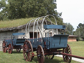
58: Ezra Meeker Mansion
| | |
Ezra Meeker Mansion | |
 | |
| Meeker Mansion is a 17 room Italianate Victorian Mansion - listed on the National Historic Register The remarkable owner was a pioneer and leading citizen of Puyallup; first mayor, one-time Hop King, author...Ezra Meeker became the self-appointed champion of the Oregon Trail in 1906, when at the age of 76, accompanied by two oxen, a wagon, a driver and a dog, he made his way from his front yard to Washington D.C., by way of New York City. His purpose was to preserve and re-mark the Oregon Trail, which was being obliterated by civilization. He thought he could make his tripe once before he died, but this remarkable man lived to 98 and made this journey by ox team once more, then by automobile in 1915, and by airplane in 1924. The fact that you can see actual traces of the Oregon Trail is due almost entirely to Ezra Meeker. | |
Ezra Meeker's Story | |
| Website | OCTA |
$[geDirections] | |
| ©2010 Ron Hall | |
Más sobre Ezra Meeker Mansion
59: Baker Heritage Museum
| | |
Baker Heritage Museum | |
 | |
| Housed in the historic 1920 Natatorium the Baker Heritage Museum, formerly Oregon Trail Regional Museum, displays and interprets the rich history of the region. Permanent and changing exhibits of mining, timber, ranching, agriculture, early Baker City life, Chinese culture and wildlife fill the 33,000 square foot building. | |
Ezra Meeker's Story | |
| Website | OCTA |
$[geDirections] | |
| ©2010 Ron Hall | |
Más sobre Baker Heritage Museum
60: Stuhr Museum
| | |
Stuhr Museum | |
 | |
| The mission of Stuhr Museum of the Prairie Pioneer is to preserve and portray the inspiring era of the pioneer town builders who created the first communities in Nebraska. Described as a "crossroads in time," Stuhr Museum preserves and portrays the inspiring story of the pioneer town builders who created the first communities in Nebraska. The pioneers who challenged the land did not think their story remarkable, but visitors and students are amazed at the spirit and accomplishments of common people who shared a vision for the future and built satisfying and productive lives on the prairie. | |
Ezra Meeker's Story | |
| Website | OCTA |
$[geDirections] | |
| ©2010 Ron Hall | |
Más sobre Stuhr Museum
61: Whitman Mission National Historic Site
| | |
Whitman Mission National Historic Site | |
 | |
| Established as a unit of the National Park Service in 1936. Today, over 60,00 people visit the site annually. The park is at the cutting edge of "green" practices and is an important haven for birds and other wildlife. | |
Ezra Meeker's Story | |
| Website | OCTA |
$[geDirections] | |
| ©2010 Ron Hall | |
Más sobre Whitman Mission National Historic Site
62: Independence Rock
| | |
Independence Rock | |
 | |
| It was the names carved in stone here that caused Father Peter J. DeSmet to appropriately name this place "The Register of the Desert" in 1840. Register Cliff and Names Hill also contain names left by the pioneers. | |
Ezra Meeker's Story | |
| Website | OCTA |
$[geDirections] | |
| ©2010 Ron Hall | |
Más sobre Independence Rock
63: Philip Foster Farm
| | |
Philip Foster Farm | |
 | |
| Philip Foster's 1847 farm was the first real civilization the pioneers encountered after their 2,000 mile trek west. Located on the Barlow Road, the Foster Farm hosted an estimated 10,000 exhausted pioneers. Visitors can explore the house, barn, store, blacksmith shop and participate in daily chores and activities that were a part of early pioneer life. The garden is home to the oldest lilac in Oregon, carried by Mrs. Foster on the sea voyage from Maine around Cape Horn. | |
Ezra Meeker's Story | |
| Website | OCTA |
$[geDirections] | |
| ©2010 Ron Hall | |
Más sobre Philip Foster Farm
64: Ash Hollow State Historical Park
| | |
Ash Hollow State Historical ParkWindlass Hill | |
 | |
| Ash Hollow. Here was fresh, clean water--a luxury the emigrants had not tasted for weeks. But getting to Ash Hollow was tricky. The pioneers had to negotiate a very steep hill. Sometimes they would let the wagons down with ropes--or get a dozen men to hold on as "human brakes." Occasionally, the brakesmen would lose control of a wagon and a severe crash would result. | |
Ezra Meeker's Story | |
| Website | OCTA |
$[geDirections] | |
| ©2010 Ron Hall | |
Más sobre Ash Hollow State Historical Park
65: Chimney Rock National Historic Site
| | |
Chimney Rock National Historic Site | |
 | |
| The site is adminstered by the Nebraska State Historical Society which operates the Ethel and Christopher J. Abbot Visitor Center at the Chimney Rock National Historic Site. The Visitor Center features museum exhibits explaining the westward migration of the nineteenth century and the significant role Chimney Rock had in the memories of those who traveled the trails west | |
Ezra Meeker's Story | |
| Website | OCTA |
$[geDirections] | |
| ©2010 Ron Hall | |
Más sobre Chimney Rock National Historic Site
66: Courthouse Rock
| | |
Courthouse Rock | |
 | |
| Courthouse and Jail Rocks, which rise 400 feet (121 m) above the North Platte Valley, are composed of Brule clay, Gering sandstone and volcanic ash. The rock formations are listed in the National Register of Historic Places and in the Nebraska Natural Areas Register. | |
Ezra Meeker's Story | |
| Website | OCTA |
$[geDirections] | |
| ©2010 Ron Hall | |
Más sobre Courthouse Rock
67: Scotts Bluff National Monument
| | |
Scotts Bluff National Monument | |
 | |
| Visitors can hike the Saddle Rock Trail, drive to the summit, visit the Oregon Trail Museum and Visitor Center, and even relive life on the Oregon Trail during the special Living History program on weekends during the summer. | |
Ezra Meeker's Story | |
| Website | OCTA |
$[geDirections] | |
| ©2010 Ron Hall | |
Más sobre Scotts Bluff National Monument
68: Three Island Crossing State Park
| | |
Three Island Crossing State Park | |
 | |
| The Oregon Trail History and Education Center Oregon Trail pioneers knew this spot well. It was one of the most famous river crossings on the historic trail. | |
Ezra Meeker's Story | |
| Website | OCTA |
$[geDirections] | |
| ©2010 Ron Hall | |
Más sobre Three Island Crossing State Park
69: Shoshone Falls
| | |
Shoshone Falls | |
 | |
| A park overlooking the waterfall is owned and operated by the City of Twin Falls. Shoshone Falls is best viewed in the spring as diversion of the Snake River for irrigation often significantly diminishes water levels in the summer and fall. Not all the emigrants had the opportunity to visit Shoshone Falls, but those who took the short side trip were in for a remarkable experience. The falls offered a fantastic view unlike any other in the US. Those who had been to Niagra noted the similarity, but Shoshone Falls is higher and has a greater volume of water than its New York cousin. | |
Ezra Meeker's Story | |
| Website | OCTA |
$[geDirections] | |
| ©2010 Ron Hall | |
Más sobre Shoshone Falls
70: Rock Creek Station
| | |
Rock Creek Station | |
 | |
| Rock Creek Station was built primarily to serve the stagecoach and Pony Express. But the Oregon-bound emigrants did stop here to purchase supplies or camp. | |
Ezra Meeker's Story | |
| Website | OCTA |
$[geDirections] | |
| ©2010 Ron Hall | |
Más sobre Rock Creek Station
71: Western Historic Trails Center
| | |
Western Historic Trails Center | |
 | |
| This visitor center is located at the gathering and jumping off point for the largest overland migration in history. The stories are told from the points of view of the Euro-Americans, many of whom kept extensive diaries, and from the points of view of the American Indians, whose lives were indelibly changed by this westward expansion. | |
Ezra Meeker's Story | |
| Website | OCTA |
$[geDirections] | |
| ©2010 Ron Hall | |
Más sobre Western Historic Trails Center
72: Craters of the Moon
| | |
Craters of the Moon | |
 | |
| Craters of the Moon (a named used only since the early 1900s) was an amazing site for the pioneers. The treeless, moonlike landscape was unlike anything they had ever seen. Unfortunately, the rocky lava flows slowed the pioneer's progress. Tim Goodale leads 1,095 emigrants and 338 wagons across a cutoff of the Oregon Trail that came to bear his name. | |
Ezra Meeker's Story | |
| Website | OCTA |
$[geDirections] | |
| ©2010 Ron Hall | |
Más sobre Craters of the Moon
73: Shawnee Mission
| | |
Shawnee Mission | |
 | |
| For many pioneers who left from Independence, Missouri,ºthe first night's camp would be at the Shawnee Mission. This Methodist outpost was built in 1839 for the purpose of teaching English and agriculture to the children of the Shawnee tribe. Here, the Oregon-bound emigrants might encounter a Native American for the first time. | |
Ezra Meeker's Story | |
| Website | OCTA |
$[geDirections] | |
| ©2010 Ron Hall | |
Más sobre Shawnee Mission
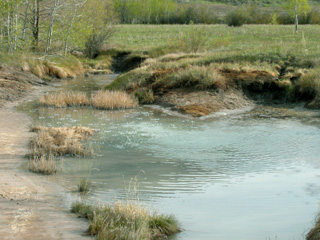
74: Alcove Spring
| | |
Alcove Spring | |
 | |
| This popular campsite was mentioned in many emigrant journals, noting the cold, clear rushing water, tall native grasses, and beautiful wildflowers blooming in profusion near the spring. | |
Ezra Meeker's Story | |
| Website | OCTA |
$[geDirections] | |
| ©2010 Ron Hall | |
Más sobre Alcove Spring
75: Independence Square
| | |
Independence Square | |
 | |
| The location of frenzied outfitting activity throughout the 1840s and early 1850s, Independence was the jumping-off point for the Santa Fe and Oregon trails. The town includes several historic buildings, monuments and Independence Spring. | |
Ezra Meeker's Story | |
| Website | OCTA |
$[geDirections] | |
| ©2010 Ron Hall | |
Más sobre Independence Square
76: Minor Park/Red Bridge Crossing
| | |
Minor Park/Red Bridge Crossing | |
 | |
| Emigrants heading west from Independence encountered their first river crossing at this site, a preview of the many rivers and streams to be negotiated on their long journey. This 27-acre park in a beautiful setting and landscape has both recreational and historic overtones. Its prominent feature is a gentle swale that cuts across the park, obviously created by wet wagon wheels and teams pulling up the hill after crossing the Big Blue River. | |
Ezra Meeker's Story | |
| Website | OCTA |
$[geDirections] | |
| ©2010 Ron Hall | |
Más sobre Minor Park/Red Bridge Crossing
77: California Hill
| | |
California Hill | |
 | |
| The Nebraska State Historical Society, who owns the resource, invites you to get out of your car and walk in the footsteps of the pioneers. The panoramic views back toward California Crossing are spectacular. Visit a marker on Highway 30, about 4.5 miles west of Brule. | |
Ezra Meeker's Story | |
| Website | OCTA |
$[geDirections] | |
| ©2010 Ron Hall | |
Más sobre California Hill
78: Guernsey Ruts (Deep Rut Hill)
| | |
Guernsey Ruts (Deep Rut Hill) | |
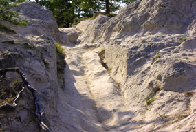 | |
| At this site, where the trail was forced away from the river and crossed a ridge of soft sandstone, the track is worn to a depth of five feet, creating some of the most spectacular ruts remaining along the entire length of the Oregon-California Trail. | |
Ezra Meeker's Story | |
| Website | OCTA |
$[geDirections] | |
| ©2010 Ron Hall | |
Más sobre Guernsey Ruts (Deep Rut Hill)
79: Soda Springs
| | |
Soda Springs | |
 | |
| The natural fountains at "Beer Springs" were rightfully considered to be one of the marvels of the overland trails. The development of the town and the building of Alexander Reservoir has destroyed or covered many of these historic springs. Steamboat Spring, Wagonbox Grave, Hooper Spring, Octagon Spring, and two short traces of ruts can still be seen in the area. | |
Ezra Meeker's Story | |
| Website | OCTA |
$[geDirections] | |
| ©2010 Ron Hall | |
Más sobre Soda Springs
80: Fort Kearny Historical Park
| | |
Fort Kearny Historical Park | |
 | |
| Archeological exploration by the Nebraska State Historical Society to locate building sites and other features has helped the Commission develop the park to give visitors an insight into the conditions and events contemporary with the settlement of the American West. | |
About Ezra Meeker | |
| Website | OCTA |
$[geDirections] | |
| ©2010 Ron Hall | |
Más sobre Fort Kearny Historical Park
81: Fort Hall
| | |
Fort Hall | |
 | |
| A visit to the Fort Hall Replica is to enter the 19th Century world of explorers, trappers, fur traders, Native Americans, pioneers, Gold seekers, historic figures, and common folk; all of whom visited the place called Fort Hall on the banks of the Snake River in what is now Southeast Idaho. The roads to the Replica follow close to the Oregon and California Trails and other famous roads and byways. | |
About Ezra Meeker | |
| Website | OCTA |
$[geDirections] | |
| ©2010 Ron Hall | |
Más sobre Fort Hall
82: Fort Boise (Marker)
| | |
Fort Boise (Marker) | |
 | |
| Originally built as fur trading post in 1834 by Thomas McKay as a private venture with an understanding of support from the Hudson's Bay Company (HBC). It became an HBC post by 1836. The decline of the fur trade caused the post to turn to the salmon fishery as a primary income producer. When the Oregon trail opened in 1841, the post was a major stop for the wagon trains crossing the Snake River into Oregon. The hospitality of the post's managers to the Oregon Trail travelers was legendary. | |
About Ezra Meeker | |
| Website | OCTA |
$[geDirections] | |
| ©2010 Ron Hall | |
Más sobre Fort Boise (Marker)
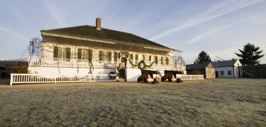
83: Fort Boise (Replica)
| | |
Fort Boise (Replica) | |
 | |
| A replica of Fort Boise is located in Fort Boise Park in Parma, Idaho, about five miles southeast of the original location. | |
About Ezra Meeker | |
| Website | OCTA |
$[geDirections] | |
| ©2010 Ron Hall | |
Más sobre Fort Boise (Replica)
84: Fort Vancouver
| | |
Fort Vancouver | |
 | |
| It was a British establishment, but the primary languages were Canadian French and Chinook Jargon. It represented British territorial interests, yet made American settlement in the Pacific Northwest possible. Even those who wished it gone praised the hospitality and assistance they found there. | |
About Ezra Meeker | |
| Website | OCTA |
$[geDirections] | |
| ©2010 Ron Hall | |
Más sobre Fort Vancouver
85: Fort Laramie
| | |
Fort Laramie | |
 | |
| Ft. Laramie marked the gateway to the Rocky Mountains. The emigrants were now one-third of the way to the Willamette. Here, they rested and regrouped. Some would give up the dream, turn around and go home. But most made the decision to push ahead. | |
About Ezra Meeker | |
| Website | OCTA |
$[geDirections] | |
| ©2010 Ron Hall | |
Más sobre Fort Laramie
86: Fort Caspar
| | |
Fort Caspar | |
 | |
| Fort Caspar was partially reconstructed in 1936 using sketches made by Lieutenant Collins in 1863. The fort itself underwent a lot of changes during its occupation, and the current recreation reflects the post in 1863-1865. The City of Casper now operates a museum at the site, which features reconstructed log buildings, including a wooden stockade. | |
About Ezra Meeker | |
| Website | OCTA |
$[geDirections] | |
| ©2010 Ron Hall | |
Más sobre Fort Caspar
87: Fort Bridger
| | |
Fort Bridger | |
 | |
| In 1928, Fort Bridger was sold to the Wyoming Historic Landmark Commission for preservation as a historic monument, now designated as Fort Bridger State Historic Site. Several original buildings remain and have been restored. The 1888 stone barracks contains a museum with artifacts from different time periods in the fort history. Visitors can also tour a reconstructed trading post and an interpretive archaeological site. | |
About Ezra Meeker | |
| Website | OCTA |
$[geDirections] | |
| ©2010 Ron Hall | |
Más sobre Fort Bridger