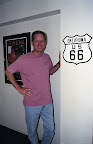
Lugares de interés (POIs) del Mapa
0: Interview: Angel Delgadillo
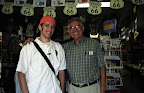 Angel called the 1987 meeting that would lead to the formation of the Historic Route 66 Association of Arizona. This group successfully lobbied to have 66 designated "historic" - as a result, signs now lead travelers off of the Interstate to stretches of road that were part of Route 66 in Arizona. |
Más sobre Interview: Angel Delgadillo
1: Interview: David Knudson
 David Knudson serves as executive director of the National Historical Route 66 Federation, which works to preserve and promote the road. He founded the Federation in 1994 after completing a trip across the country, when he was unable to locate old sections of Route 66 that he remembered traveling in college. |
Más sobre Interview: David Knudson
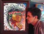
2: Interview: Michael Wallis
 | Michael Wallis was born and raised on Route 66 and has lived andtraveled along it ever since. He has authored 11 best-selling books,including "Route 66: The Mother Road" (1990), which is a main sourceof information for Route 66 enthusiasts. |
Más sobre Interview: Michael Wallis
3: Interview: Bob Waldmire
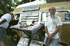 If you find yourself behind a yellow VW Bus going twenty miles per hour below the speed limit on a stretch of I-40 that has replaced Route 66, you've probably found Bob Waldmire. Bob, who is best known for his hand-drawn maps and postcards of Route 66, likes to drive slowly so that butterflies are blown over his car rather than into the windshield. |
Más sobre Interview: Bob Waldmire
4: Interview: Jerry McClanahan
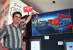  Jerry has worked full-time as a Route 66 artist for more than 10 years now. He collaborated with Jim Ross to create the "Here it Is" Route 66 map series, and has done numerous paintings and postcards that focus on the road. We caught up with Jerry at the Route 66 Museum in Clinton, OK where he was exhibiting some of his work. |
Más sobre Interview: Jerry McClanahan
5: Interview: Ken Turmel
Ken Turmel - known by many along Route 66
as the Land Runner - spent two years traveling
the road to collect post office stamps for his
Route 66 map.
Interview questions
Más sobre Interview: Ken Turmel
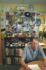
6: Interview: Mike Callens
 | Mike runs the Teepee Curio Shop in Tucumcari, New Mexico. |
Más sobre Interview: Mike Callens
7: Interview: Jim Ross
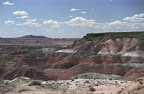
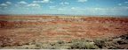
 | Jim, who worked with Jerry McClanahan to publish the "Here It Is" Route 66 Map Series in 1994, lives in a house built to resemble an old Phillips 66 gas station. His writing credits include a number of articles for the Route 66 magazine, as well as two books on Route 66, the most recent of which is titled "Oklahoma Route 66". |
Más sobre Interview: Jim Ross
8: Interview: Bill Gilmore
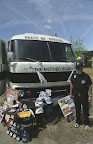 | Bill, a Route 66 fan, collects memorabilia relating to the road and displays it in his RV, the "Route 66 Special". |
Más sobre Interview: Bill Gilmore
9: Interview: Pat Evans
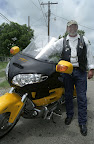 | Pat led the 8th annual Mother Road Ride and Rally, a motorcycle tour along Route 66. His group of cyclists passed through Stroud, OK as we were conducting interviews at the Rock Cafe. |
Más sobre Interview: Pat Evans
10: Interview: Wayne Marshall
 | Wayne is the principal of Route 66 Elementary School in Edgewood, NM. As far as Wayne knows, his school is the only one named after the road. |
Más sobre Interview: Wayne Marshall
11: Interview: Bob Audette
Bob is a true "Mr. Sixty-Six", born the
same year as the road itself.
Interview questions
Más sobre Interview: Bob Audette
12: Interview: Becky Ransom
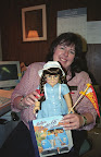 | Becky is Human Resources manager at the Big Texan Steak Ranch in Amarillo, Texas, where they'll give you a free 72oz steak, as long as you can eat it all in an hour. |
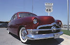
Más sobre Interview: Becky Ransom
13: Interview: Sid Melton
 | Sid lives on Route 66 in Joplin, MO, where the city has re-routed the road through commercial areas in order to take advantage of the recent renewed tourist interest in 66. |
Más sobre Interview: Sid Melton
14: Photo: Abandoned Car
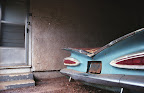 Abandoned car at the ruins of the West Winds Motel. These Erick, OK ruins have run-down classic cars parked in most of the carports. |
Más sobre Photo: Abandoned Car
15: Photo: Cold Beer
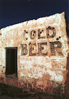 Advertisement painted on wall of ruins along Route 66. With fewer travelers passing by to buy food, drinks and souveneirs, shops::text like this one failed quickly after the interstate was built. (Location approximate.) |
Más sobre Photo: Cold Beer
16: Photo: Painted Route 66 Shield
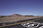 A few places on Route 66 have the highway shields painted directly on the road. One possible reason: it's much harder to steal these than the metal signs, which tend to disappear. |
Más sobre Photo: Painted Route 66 Shield
17: Photo: "Dr. Seuss Plants"
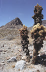 On the old, winding road to Oatman, AZ, these desert shrubs reminiscent of something out of a Dr. Seuss book abound. |
Más sobre Photo: "Dr. Seuss Plants"
18: Photo: The Teepees
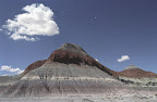 A cloud floats lazily past one of "The Teepees" in the Petrified Forest National Park, one of the natural wonders that can be seen along the route. |
Más sobre Photo: The Teepees
19: Photo: Midpoint Cafe
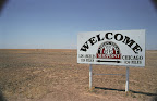 A sign across the road from the Midpoint Cafe tells you that you're roughly midway on the route between Chicago and Los Angeles, at the center of the old road. |
Más sobre Photo: Midpoint Cafe
20: Photo: Population 20
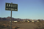 Once an important fueling stop for motorists travelling through the California desert, Amboy is typical of many bypassed towns on the old road - small (population 20) and forgotten. Just west of town is the Amboy Crater and surrounding lava fields. |
Más sobre Photo: Population 20
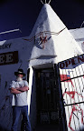
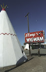
21: Photo: Sleep in a Wigwam (CA)
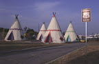 California's Wigwam Motel, one of a few places along the old road that offers the chance to "sleep in a wigwam". |
Más sobre Photo: Sleep in a Wigwam (CA)
22: Photo: U Drop Inn
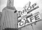 The sign of the "U-Drop-Inn Cafe" on Route 66 in Shamrock, TX. |
Más sobre Photo: U Drop Inn
23: Photo: Original Route 66
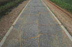 One of the original sections of Route 66 roadway, between Afton, OK and Miami (My-am-uh), OK. This eight-foot section is wide enough for only a single car and is poorly paved... it gives a little glimpse of what driving was::text like in the days of the early automobile. |
Más sobre Photo: Original Route 66
24: Photo: Oatman
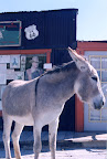 Walk into Oatman and step back in time to the Wild West. You'll even find donkeys wandering the streets. |
Más sobre Photo: Oatman
25: Photo: Twin Arrows
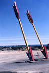 These two large arrows beckoned visitors to the Twin Arrows Trading Post.::text Like many other Route 66 landmarks, the trading post and restaurant are now abandoned. (More recent photos show that the arrows themselves have fallen into disrepair as well.) |
Más sobre Photo: Twin Arrows
26: Photo: Sleep in a Wigwam (AZ)
 Arizona's Wigwam Motel (Holbrook), one of a few places along the old road that offers the chance to "sleep in a wigwam". |
Más sobre Photo: Sleep in a Wigwam (AZ)
27: Photo: Painted Desert
  Overlooking the Painted Desert in the Petrified Forest National Park. |
Más sobre Photo: Painted Desert
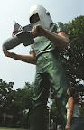
28: Photo: Gemini Giant
 This huge statue at the Launching Pad Drive-In in Wilmington, IL was named to honor the US space program. |
Más sobre Photo: Gemini Giant
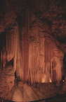
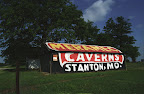
29: Photo: Meramec Caverns
 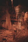 The stalactites and stalagmites are the main attractions at Stanton, MO's Meramec Caverns, which is also famed for being the outlaw Jesse James' hideout. Advertisements painted on barns draw visitors from hundreds of miles away. |
Más sobre Photo: Meramec Caverns
30: Photo: Chain of Rocks Bridge
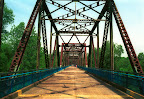 This decommissioned bridge on Old Route 66 now serves as a pedestrian walkway and trail. |
Más sobre Photo: Chain of Rocks Bridge
31: Photo: Lincoln Home
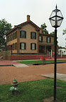 Abraham Lincoln's home, in Springfield, IL, is one of the historic sites just a few blocks off of Route 66. |
Más sobre Photo: Lincoln Home
32: Photo: Rainbow Bridge
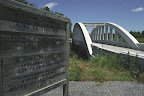 This bridge near RIverton, KS has been bypassed by a wider concrete bridge on the new road adjacent to it. The bridge is a favorite target of local high-schoolers, who often paint or graffiti it as a end-of-year prank. |
Más sobre Photo: Rainbow Bridge
33: Photo: Big Blue Whale
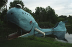 The Blue Whale near Catoosa, OK was a favorite swimming hole of local youths until it closed in the late 80s. There's no swimming today, and ruins of one of the boats that visitors could paddle now float just next to the whale. |
Más sobre Photo: Big Blue Whale
34: Photo: Painted Barn Advertisement
 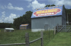 Meramec Caverns has painted advertisements on barns::text like this one near Warwick, OK for hundreds of miles in either direction along Route 66, enticing travelers to visit the attraction. |
Más sobre Photo: Painted Barn Advertisement
35: Photo: Round Barn
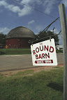 The historic round barn in Arcadia, OK. Barns were built this way so that they would be more resistant to high winds. |
Más sobre Photo: Round Barn
36: Photo: Junkyard Art
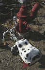 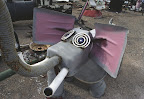 Junkyard art on Route 66 near Edgewood, NM. All of the creations are made with junk recovered from alongside Route 66. |
Más sobre Photo: Junkyard Art
37: Photo: Cadillac Ranch
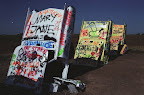 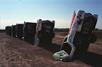 Ever wondered what you'd do if you were a millionaire? Stanley Marsh buried ten cadillacs face-down in a field just west of Amarillo, TX. Visitors add their own graffitied messages to the cars. |
Más sobre Photo: Cadillac Ranch
38: Photo: Big Texas Weather
| Lightning storm west of Amarillo, TX. Some of the sights on Route 66 can't be found on a map or schedule.
|
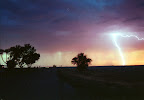
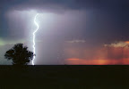
Más sobre Photo: Big Texas Weather
39: Photo: Restored Phillips Station
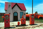 This restored gas station in McLean, TX attempts to show what stations were::text like in the heyday of Route 66. |
Más sobre Photo: Restored Phillips Station
40: Photo: Leaning Tower of Texas
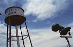 "The Leaning Tower of Texas" - erected in hopes of drawing curious passers-by on Route 66 to the stores of Groom, TX. |
Más sobre Photo: Leaning Tower of Texas

42: Photo: Route 66 times 3
 With all the back-and-forth we did on Route 66, we had driven more than three times the length of the old road by the time we reached Litchfield, IL (we drove west-to-east). |
Más sobre Photo: Route 66 times 3
43: Photo: Route 66 Auto Museum
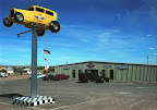  "Bozo" Cordova hoisted this classic car atop a pole to advertise for his Route 66 Auto Museum in Santa Rosa, NM, where he displays cars::text like the one on the right. |
Más sobre Photo: Route 66 Auto Museum
44: Photo: Roy's
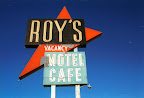 Sign outside Roy's Motel and Cafe in Amboy, CA. Even in 2002, when gas prices were around $1 per gallon, those caught in the middle of the desert would have to pay three times that. A stranded traveler we met decided to wait for AAA to bring gas from elsewhere rather than pay Roy's prices. |
Más sobre Photo: Roy's
45: Photo: Nostalgia
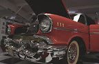
 Classic car outside of Oklahoma Route 66 Museum, Clinton, OK. Multiple times during the day when we were interviewing at the museum, people would rush outside to see classic cars that had arrived, such as this one with Texas "nostalgia" plates. |
Más sobre Photo: Nostalgia
46: Photo: To Infinity and Beyond...
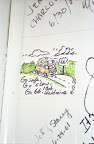 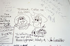 Writing on the wall in the bathroom at the Rock Cafe in Stroud, OK. About a year before our research project on Route 66, John Lasseter and the Pixar crew followed the same route to do research for the movie Cars. Elsewhere on the wall, a message from Bob Waldmire, who we interviewed in Chandler. |
Más sobre Photo: To Infinity and Beyond...