Mapping the way - WaterAid (sitios de interés)
Descripción del sitio
 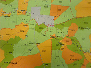 WaterAid | Vinny Casey WaterAid | Mapping the way In the past there was no data showing where water and sanitation facilities were located in Malawi, and so access to safe water was inequitable with some communities having many water points, while others had none. In response to the problem WaterAid initiated a water point mapping project to determine the location and functionality of water services in rural communities. The whole of the country has now been mapped and the research shows that only 57% of the population have access to safe water - considerably lower than the 73% quoted as the official figure. These maps can now be used to plan and coordinate future work to ensure it reaches those who need water the most. Find out more about WaterAid in Malawi.(c) WaterAid 2008 |